ATL: MATTHEW - Ex-Tropical Storm - Discussion
Moderator: S2k Moderators

Re: ATL: MATTHEW - Tropical Storm - Discussion
Current shear analysis from CIMSS is 16 knots and from SHIPS is 13 knots.
0 likes

Re: ATL: MATTHEW - Tropical Storm - Discussion
31kt at a buoy about 100 miles north...29.75"
http://www.ndbc.noaa.gov/station_page.php?station=42057
Recon on the way in...about halfway there....interesting little 180 degree windshift just south of the DR (baby nicole? grin)
Shows how humbling nature can be...had a C130, global hawk, and couple jets in the area with a good initial fix and high altitude sampling and the models are still blowing up.
0 likes
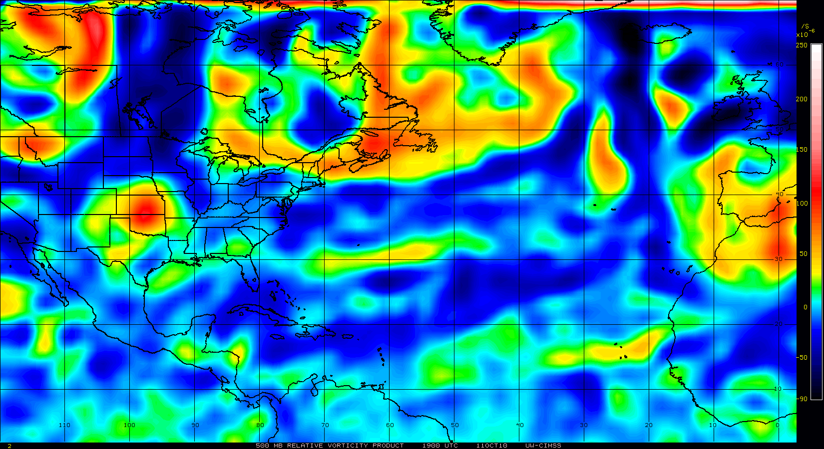
Re: ATL: MATTHEW - Tropical Storm - Discussion
For just a TS, very strong vorticity at 500mb.
0 likes
-
Evil Jeremy

- S2K Supporter

- Posts: 5463
- Age: 32
- Joined: Mon Apr 10, 2006 2:10 pm
- Location: Los Angeles, CA
Re: ATL: MATTHEW - Tropical Storm - Discussion
AFTER THAT TIME...THERE IS SERIOUS
DIVERGENCE IN THE GUIDANCE. THE OPERATIONAL GLOBAL MODELS AGREE
THAT MATTHEW SHOULD CONTINUE WEST-NORTHWESTWARD ACROSS THE SOUTHERN
YUCATAN PENINSULA AND/OR GUATEMALA...WITH THE UKMET SHOWING THE
CENTER REACHING THE BAY OF CAMPECHE. ON THE OTHER HAND...THE
GFDL..HWRF...AND GFS ENSEMBLE MEAN FORECAST MATTHEW TO REACH THE
EAST COAST OF YUCATAN AND THEN TURN NORTHEASTWARD. THE DIFFERENCES
APPEAR TO STEM FROM THE INTERACTION OF MATTHEW WITH A DEVELOPING
MONSOON LOW PRESSURE AREA OVER CENTRAL AMERICA AND THE ADJACENT
WATERS...AND TO A LESSER EXTENT ON THE DEVELOPMENT OF A DEEP-LAYER
TROUGH OVER THE CENTRAL AND EASTERN UNITED STATES. FOR NOW...THE
TRACK FORECAST WILL COMPROMISE BETWEEN THESE EXTREMES AND CALL FOR
A SLOW NORTHWARD MOTION OVER THE YUCATAN PENINSULA TO KEEP
CONTINUITY FROM THE PREVIOUS FORECAST. HOWEVER...THIS IS A
LOW-CONFIDENCE FORECAST...AND SIGNIFICANT CHANGES MAY BE REQUIRED
LATER TODAY.
Does not sound like the NHC is confident that Matt will stay inland Yucatan. Going by their wording in the last several discussions, I think they think that Matt will not stay inland and will indeed continue N and then NE, but they can't just go against the computer models, as misguided as they may be.
0 likes
Frances 04 / Jeanne 04 / Katrina 05 / Wilma 05 / Fay 08 / Debby 12 / Andrea 13 / Colin 16 / Hermine 16 / Matthew 16 / Irma 17

Re: ATL: MATTHEW - Tropical Storm - Discussion
I myself was wondering how a meteorologist could say such a thing! Perhaps he needs to have a detailed look at this archive or something.wxman57 wrote:otowntiger wrote:I heard a local met here in Orlando just a little earlier this evening actually say that 'we are getting close to that time of the season where rapid intensification is much less likely.' I'm not sure that's a correct statement. I've seen numerous storms over the years in late Sept/early Oct. really ramp up in a hurry. Did the guy 'mispeak' or am I crazy?
Ask him if he ever heard of Wilma (mid October) or Mitch (late October) or Opal (early October), or a bunch of other rapid intensifiers in the Caribbean late in the season. This is a prime region for rapid intensification, particularly this time of year.

0 likes
Re: ATL: MATTHEW - Tropical Storm - Discussion
Latest SREF has the cutoff low forming over IL Sunday 12Z.
Will be over north MS Monday 18Z


Will be over north MS Monday 18Z
0 likes


Well looks like it'll make landfall in the next 12hrs south of the NHC track I'd imagine, looks like that means the chances of Matthew surviving are greatly reduced and therefore we need to start looking much more closely at the mess that is left behind which would probably become Otto.
0 likes
Personal Forecast Disclaimer:
The posts in this forum are NOT official forecast and should not be used as such. They are just the opinion of the poster and may or may not be backed by sound meteorological data. They are NOT endorsed by any professional institution or storm2k.org. For official information, please refer to the NHC and NWS products
The posts in this forum are NOT official forecast and should not be used as such. They are just the opinion of the poster and may or may not be backed by sound meteorological data. They are NOT endorsed by any professional institution or storm2k.org. For official information, please refer to the NHC and NWS products
Re: ATL: MATTHEW - Tropical Storm - Discussion
The 6z GFS still supports landfall at the Nic/Hond border and then grazing the coast. I think once we can get a VDM or two we will be able to tell a lot better.
0 likes
Re:
HURAKAN wrote::uarrow: Where's Nicole?
Well thats the toughie there Hurakan, it effectivly comes from Matthew in the end, or at least the energy rotates around as Matthew dies off...its pretty much the case that if Matthew survives in any decent form, there will be no Nicole from this....if Matthew dies, then I'd say just about certain another TC forms givcen the broad low pressure region already in place that develops....but I don't think there can be both at the same time...at least not with any decent strength.
0 likes
Personal Forecast Disclaimer:
The posts in this forum are NOT official forecast and should not be used as such. They are just the opinion of the poster and may or may not be backed by sound meteorological data. They are NOT endorsed by any professional institution or storm2k.org. For official information, please refer to the NHC and NWS products
The posts in this forum are NOT official forecast and should not be used as such. They are just the opinion of the poster and may or may not be backed by sound meteorological data. They are NOT endorsed by any professional institution or storm2k.org. For official information, please refer to the NHC and NWS products
-
HURAKAN

- Professional-Met

- Posts: 46084
- Age: 39
- Joined: Thu May 20, 2004 4:34 pm
- Location: Key West, FL
- Contact:
Re: Re:
KWT wrote:HURAKAN wrote::uarrow: Where's Nicole?
Well thats the toughie there Hurakan, it effectivly comes from Matthew in the end, or at least the energy rotates around as Matthew dies off...its pretty much the case that if Matthew survives in any decent form, there will be no Nicole from this....if Matthew dies, then I'd say just about certain another TC forms givcen the broad low pressure region already in place that develops....but I don't think there can be both at the same time...at least not with any decent strength.
I just asked that bc you said that Otto forms.
0 likes
-
gatorcane

- S2K Supporter
- Posts: 23708
- Age: 48
- Joined: Sun Mar 13, 2005 3:54 pm
- Location: Boca Raton, FL
Wow that nhc disco is interesting. That is telling me theY may start to show the nw turn with the track shifted more to the east and a stronger system as a result.
I have grown more concerned for Florida with the trends I am seeing in the models. Gfs and euro keep showing ane turn into sw or south Florida.
It's somewat Wilma-esque with what the gfs and euro are showing
I have grown more concerned for Florida with the trends I am seeing in the models. Gfs and euro keep showing ane turn into sw or south Florida.
It's somewat Wilma-esque with what the gfs and euro are showing
Last edited by gatorcane on Fri Sep 24, 2010 6:38 am, edited 1 time in total.
0 likes
-
HURAKAN
- Professional-Met
- Posts: 46084
- Age: 39
- Joined: Thu May 20, 2004 4:34 pm
- Location: Key West, FL
- Contact:
Computer models are making it more complicated than it has to be, that's my opinion. Matthew probably will move over northern Nicaragua and Honduras and by tomorrow or Sunday, as the trough weakens the ridge, it will begin to slowdown and turn move northwest. It may emerge or not over the Gulf of Honduras. Then, early next week, the trough makes it turn north and northeast. It could be a hurricane, tropical storm, depression or remnants, I don't know. But the idea of another cyclone forming next to it or from its remnants in the next few days sounds more crazy. It's very complex due to land interaction. I personally wouldn't want to bet on anything right now!!
Code: Select all
Personal Forecast Disclaimer:
The posts in this forum are NOT official forecast and should not be used as such. They are just the opinion of the poster and may or may not be backed by sound meteorological data. They are NOT endorsed by any professional institution or storm2k.org. For official information, please refer to the NHC and NWS products.
0 likes
-
HURRICANELONNY
- Category 5

- Posts: 1392
- Joined: Wed May 07, 2003 6:48 am
- Location: HOLLYWOOD.FL
Re: ATL: MATTHEW - Tropical Storm - Discussion
I wouldn't put much emphasis in the models right now. Just a wait and see down here. Always should be prepared. I'll probably fill my tank just for the heck of it. I'll use it anyways.
0 likes
hurricanelonny

Re:
HURAKAN wrote:Computer models are making it more complicated than it has to be, that's my opinion. Matthew probably will move over northern Nicaragua and Honduras and by tomorrow or Sunday, as the trough weakens the ridge, it will begin to slowdown and turn move northwest. It may emerge or not over the Gulf of Honduras. Then, early next week, the trough makes it turn north and northeast. It could be a hurricane, tropical storm, depression or remnants, I don't know. But the idea of another cyclone forming next to it or from its remnants in the next few days sounds more crazy. It's very complex due to land interaction. I personally wouldn't want to bet on anything right now!!Code: Select all
Personal Forecast Disclaimer:
The posts in this forum are NOT official forecast and should not be used as such. They are just the opinion of the poster and may or may not be backed by sound meteorological data. They are NOT endorsed by any professional institution or storm2k.org. For official information, please refer to the NHC and NWS products.
It sounds complex but actually its no different to many examples of early season storms that we see in the CAribbean which form from an EPAC storm then the energy transfers NE into the CAribbean. The only difference with it is instead of an EPAC storm you have an Atlantic storm instead buit the processes are the same.
Of course that is not to say that the idea of another system taking is more likely but its IMO every bit as likely as any other solution we have out there at the moment to be honest!
Models will be all over the place for a while yet but so far looks like the ECM is on track and that model kills off Matthew (actually it gets into the EPAC as a vort feature...) then relocates the energy eastwards by 72hrs and something new forms from the leftover energy and lower pressures.
0 likes
Personal Forecast Disclaimer:
The posts in this forum are NOT official forecast and should not be used as such. They are just the opinion of the poster and may or may not be backed by sound meteorological data. They are NOT endorsed by any professional institution or storm2k.org. For official information, please refer to the NHC and NWS products
The posts in this forum are NOT official forecast and should not be used as such. They are just the opinion of the poster and may or may not be backed by sound meteorological data. They are NOT endorsed by any professional institution or storm2k.org. For official information, please refer to the NHC and NWS products

Quite a decent convective ball there Hurakan, wonder where the LLC is in relation to that convective mass...either way the weather is heading close to land now thats for sure, going to be a rough day.
0 likes
Personal Forecast Disclaimer:
The posts in this forum are NOT official forecast and should not be used as such. They are just the opinion of the poster and may or may not be backed by sound meteorological data. They are NOT endorsed by any professional institution or storm2k.org. For official information, please refer to the NHC and NWS products
The posts in this forum are NOT official forecast and should not be used as such. They are just the opinion of the poster and may or may not be backed by sound meteorological data. They are NOT endorsed by any professional institution or storm2k.org. For official information, please refer to the NHC and NWS products
-
wxman57

- Moderator-Pro Met

- Posts: 23175
- Age: 68
- Joined: Sat Jun 21, 2003 8:06 pm
- Location: Houston, TX (southwest)
Re: ATL: MATTHEW - Tropical Storm - Discussion
Note that the 12Z NHC position is on the northeast edge of the convection. Track needs to be adjusted south. Matthew is already 30 miles south of the 9Z track. It may be over Nicaragua and Honduras for quite a while, only briefly emerging over water before moving into Belize.
0 likes
Who is online
Users browsing this forum: No registered users and 116 guests