Here is the radar from Bermuda. It is starting to show bands of rain to the south.
http://www.weather.bm/radarLarge.asp
ATL: IGOR - Ex Hurricane - Discussion
Moderator: S2k Moderators
-
cycloneye

- Admin

- Posts: 149721
- Age: 69
- Joined: Thu Oct 10, 2002 10:54 am
- Location: San Juan, Puerto Rico
Re: ATL: IGOR - Hurricane - Discussion
0 likes
Visit the Caribbean-Central America Weather Thread where you can find at first post web cams,radars
and observations from Caribbean basin members Click Here
and observations from Caribbean basin members Click Here

-
plasticup
Re:
yzerfan wrote:Headlines from the Royal Gazette
http://www.royalgazette.com/rg/Article/ ... ctionId=60
http://www.royalgazette.com/rg/Article/ ... ctionId=60
Thankfully, they're shutting down the Causeway early this time. IIRC, that's where the Fabian deaths occurred.
Yep, someone tried to cross in the height of the storm and got stuck. The police went out to save them, and all were washed away. I don't think anyone ever figured out why there were crossing in the first place, but the rumor was that they were trying to get to the hospital. After that, the government set up very strict criteria for closing the causeway during high winds/seas.
0 likes
-
cycloneye
- Admin
- Posts: 149721
- Age: 69
- Joined: Thu Oct 10, 2002 10:54 am
- Location: San Juan, Puerto Rico
Re: ATL: IGOR - Hurricane - Discussion
As of the 11 AM Advisory,the forecast track has it only 3.7 miles.
Results for Bermuda (32.37N, 64.68W):
The approximate Closest Point of Approach (CPA) is located near 32.4N, 64.7W or about 3.7 miles (6.0 km) from your location. The estimated time of when the center of the storm will be at that location is in about 41.5 hours (Monday, September 20 at 4:30AM AST).
http://stormcarib.com/closest1.htm
0 likes
Visit the Caribbean-Central America Weather Thread where you can find at first post web cams,radars
and observations from Caribbean basin members Click Here
and observations from Caribbean basin members Click Here
-
bvigal

- S2K Supporter

- Posts: 2276
- Joined: Sun Jul 24, 2005 8:49 am
- Location: British Virgin Islands
- Contact:
Re: Re:
plasticup wrote:yzerfan wrote:Headlines from the Royal Gazette
http://www.royalgazette.com/rg/Article/ ... ctionId=60
http://www.royalgazette.com/rg/Article/ ... ctionId=60
Thankfully, they're shutting down the Causeway early this time. IIRC, that's where the Fabian deaths occurred.
Yep, someone tried to cross in the height of the storm and got stuck. The police went out to save them, and all were washed away. I don't think anyone ever figured out why there were crossing in the first place, but the rumor was that they were trying to get to the hospital. After that, the government set up very strict criteria for closing the causeway during high winds/seas.
I remember well when this happened. Igor is like Katrina or Ike. It may be "only" a Category 2, but the surge will be far worse and come sooner than the winds. They should close the causeway sooner, it has nothing to do with winds, but swell. One should also not tell the public it's a 2 not a 3 when it's 95kt, because 96kt is a 3!
0 likes
-
somethingfunny

- ChatStaff

- Posts: 3926
- Age: 37
- Joined: Thu May 31, 2007 10:30 pm
- Location: McKinney, Texas
Re: ATL: IGOR - Hurricane - Discussion
My goodness, a Category Two hurricane with a 939mb central pressure. This takes the cake from other famously powerful Category Two hurricanes doesn't it?
Steady-state, highly spread out hurricanes with Cat4 pressures and Cat2 winds almost seem to be a completely separate breed of hurricane, like they ought to have their own classification. Ike@TX, Frances@FL, Alex of 2010, Gustav@LA, Georges@FL/MS.... There's lots of famous names in this group, but Igor is the king of them all!
My prayers go out to Bermuda that everyone remains safe and their building codes handle this test well. I think the long duration of winds will make Igor more damaging than Fabian. Just like in 2004 (in Florida), Frances caused nearly twice as much property damage as Jeanne did - lower maximum winds, but longer duration caused much more damage.
0 likes
I am not a meteorologist, and any posts made by me are not official forecasts or to be interpreted as being intelligent. These posts are just my opinions and are probably silly opinions.
-
bvigal
- S2K Supporter
- Posts: 2276
- Joined: Sun Jul 24, 2005 8:49 am
- Location: British Virgin Islands
- Contact:
Re: ATL: IGOR - Hurricane - Discussion
hurricaneCW wrote:I think some people have explained this before but the hurricane is not going to go directly from one point to the other. Igor will most likely approach the point past Bermuda while it's gradually curving from the N to the NNE and NE. This means that Igor could curve right on top of Bermuda and even just to the west of it.
abajan wrote:That’s actually incorrect because storms don’t move in straight lines from point to point as illustrated on the chart. If the track line were smoothed out, the eye would indeed go directly over Bermuda. That’s why I think the line should not be included on the charts. But you are certainly correct in stating that Igor (more precisely, its center) could do anything (go anywhere) within the error cone.Blown Away wrote:Igor could do anything within the error cone but for now the NHC has Igor passing just east of Bermuda. It only takes a 75-100 mile east shift to keep the core hurricane winds just offshore.
The preceding post is NOT an official forecast and should not be used as such. It is just the opinion of the poster and may or may not be backed by sound meteorological data. It is NOT endorsed by any professional institution including storm2k.org. For Official Information please refer to the NHC and NWS products.
weatherguy2 wrote:Yep, I agree, 100%, The western Eye wall will pretty much pass right over Bermuda if the NHC Advisory #39 forecast track is right.
Hurricanes in the large scale have smooth track lines not jagged. The NHC lines are not for a real track, they only connect the forecasted points. The best of the early cycle 18z models also follow the spline line on my map below.
here is a map I made to explain to people that are confused:
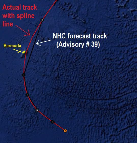
This illustration of the curved track of hurricanes is so important, it cannot be stressed enough. This is the same reason why I don't use those "closest point" calculators. They can be very accurate, or way off, depending upon the fix points available from the current advisory, and how far in between them lies the point you are checking. Because they calculate a straight line between points, then calculate the distance of your point from that line. It's good for general interest, but not accurate enough to differentiate between a few miles of a hurricane eyewall or not.
0 likes
Re:
CrazyC83 wrote:Based on current data, this has to be the most intense Cat 1 ever...the RMW is ENORMOUS as well...
Correction: based on latest FL winds, I would blend out to 85 kt (even though that supports 100 kt).
I know, it's so strong it even has category 2 force winds.
0 likes
-
bvigal
- S2K Supporter
- Posts: 2276
- Joined: Sun Jul 24, 2005 8:49 am
- Location: British Virgin Islands
- Contact:
Re: ATL: IGOR - Hurricane - Discussion
Is recon finding only a Cat 1?  Is that estimated, or actual from dropsondes?
 Wow, Cat 1 will be an even more dangerous thing to tell the public! I can hear it now... "We thought we were only getting hit with a Cat 1! How come the winds/seas did so much damage?"
0 likes
-
bvigal
- S2K Supporter
- Posts: 2276
- Joined: Sun Jul 24, 2005 8:49 am
- Location: British Virgin Islands
- Contact:
Re: ATL: IGOR - Hurricane - Discussion
Is recon finding only a Cat 1? Is that estimated, or actual from dropsondes?
Wow, Cat 1 will be an even more dangerous thing to tell the public! I can hear it now... "We thought we were only getting hit with a Cat 1! How come the winds/seas did so much damage?"
0 likes
-
plasticup
Re: ATL: IGOR - Hurricane - Discussion
bvigal wrote:Is recon finding only a Cat 1?
Naw, people in Bermuda are really tense for this one. The regiment has been called up, grocery stores are empty, business are closed next Monday and maybe Tuesday. With the building codes as strong as they are folks always fear the surge more than the wind.
0 likes
-
bvigal
- S2K Supporter
- Posts: 2276
- Joined: Sun Jul 24, 2005 8:49 am
- Location: British Virgin Islands
- Contact:
Re: ATL: IGOR - Hurricane - Discussion
Thanks for that! Did you say you were in Florida, with family in Bermuda? (your profile doesn't list a locationplasticup wrote:bvigal wrote:Is recon finding only a Cat 1?
Naw, people in Bermuda are really tense for this one. The regiment has been called up, grocery stores are empty, business are closed next Monday and maybe Tuesday. With the building codes as strong as they are folks always fear the surge more than the wind.
0 likes
-
CrazyC83
- Professional-Met

- Posts: 34316
- Joined: Tue Mar 07, 2006 11:57 pm
- Location: Deep South, for the first time!
Also Recon found an 80 mile wide eye - I can't remember there ever being such a mammoth eye. The EYE could probably fit in the entire circulation of Charley (2004) for comparison...
Last edited by CrazyC83 on Sat Sep 18, 2010 11:29 am, edited 1 time in total.
0 likes

-
plasticup
Re: ATL: IGOR - Hurricane - Discussion
bvigal wrote:Thanks for that! Did you say you were in Florida, with family in Bermuda? (your profile doesn't list a location)
I'm in North Carolina now, but I lived in Bermuda through Fabian. My family is still there, and I'm sure I will be again one day.
shah8 wrote:Surge will mostly go around Bermuda. It's the waves on top of the surge that's dangerous.
Plus lengthy hurricane conditions. There is just going to be a ton of water and wind. Fabian was a smaller system.
Fabian was pretty big. When it crossed Bermuda, hurricane force winds had a diameter of approximately 135 miles and a TS diameter of 400 miles. That's more or less the same as Igor.
0 likes
-
bvigal
- S2K Supporter
- Posts: 2276
- Joined: Sun Jul 24, 2005 8:49 am
- Location: British Virgin Islands
- Contact:
Re:
In Hurricane Mitch, they found winds less at flight level than on the surface. Some storms just don't follow the rules!CrazyC83 wrote:FL winds support Cat 3, but SFMR only supports Cat 1 - clearly the 90% rule does not apply here. I'd go with 85 kt as a blend of the data leaning towards the SFMR.
Source: The Ship and the Storm by Jim Carrier, (a friend, so don't worry about the quote). p159, pp6, about recon flight:
At 10,000 feet, the airplane measured 125 knots of wind. Using the standard 15 percent reduction to calculate sea-level sppeds, (James) Franklin expected speeds below to be in the 100- to 110-knot range, a Category 3 hurricane. But Franklin's dropsondes showed the wind speeds increasing the closer it got to the ocean. "They just kept going up and up and up." Actual speeds of 115 knots were found at or near the water, but readings of 150,165, and 180 knots also were found in places in the eye wall. Several dropsondes stopped working in the turbulence."
It's a wonderful book, by the way!
0 likes
-
lostinthetriangle
- Tropical Low

- Posts: 25
- Joined: Wed Sep 15, 2010 5:10 pm
- Location: Bermuda
Re: Re:
bvigal wrote:plasticup wrote:yzerfan wrote:Headlines from the Royal Gazette
http://www.royalgazette.com/rg/Article/ ... ctionId=60
http://www.royalgazette.com/rg/Article/ ... ctionId=60
Thankfully, they're shutting down the Causeway early this time. IIRC, that's where the Fabian deaths occurred.
Yep, someone tried to cross in the height of the storm and got stuck. The police went out to save them, and all were washed away. I don't think anyone ever figured out why there were crossing in the first place, but the rumor was that they were trying to get to the hospital. After that, the government set up very strict criteria for closing the causeway during high winds/seas.
I remember well when this happened. Igor is like Katrina or Ike. It may be "only" a Category 2, but the surge will be far worse and come sooner than the winds. They should close the causeway sooner, it has nothing to do with winds, but swell. One should also not tell the public it's a 2 not a 3 when it's 95kt, because 96kt is a 3!
Just came back from a drive looking at the Airport and St. Davids, winds are picking up and the waves are getting bigger. The airport is shutting down around 1700 will remain shut until Monday................at the earliest (I think later). The storm surge from Fabian took a heavy toll on the departure area.
The latest from the NHC suggests closest point early hours Monday. That is a lot of wind for a long period of time, most people here are taking Igor very serious.
0 likes
Who is online
Users browsing this forum: No registered users and 55 guests