

ATL: IGOR - Ex Hurricane - Discussion
Moderator: S2k Moderators
-
weatherSnoop

- S2K Supporter

- Posts: 702
- Age: 63
- Joined: Wed Oct 09, 2002 10:06 pm
- Location: Tampa, FL
- Contact:
-
Florida1118
Re:
weatherSnoop wrote:"THE BUOY HAS NOW REPORTED TROPICAL STORM FORCE
WINDS FOR 21 CONSECUTIVE HOURS." from NHC
Buoy is smaller than Bermuda...I hope for a miss and fast movement, as the alternative makes for a verrrrry long day/night
Just listening to a video in hurricane Wilma (Cat. 3), It sounded like a women screaming non-stop. I couldnt listen to that for more than 3min. Hearing that sound for 10+ hours...Id go Insane.
0 likes
-
ozonepete
- Professional-Met

- Posts: 4743
- Joined: Mon Sep 07, 2009 3:23 pm
- Location: From Ozone Park, NYC / Now in Brooklyn, NY
Re: ATL: IGOR - Hurricane - Discussion
Hey Hurakan, how far apart are Igor and Julia now? I have 1,000 miles.
0 likes

Re:
RL3AO wrote:Heres what Igor would look like in the GOM for size comparisons.
http://i54.tinypic.com/2edr57a.jpg
And yes those are the Antillies in the BOC. I didn't want to take that long making the image.
Wow, thanks for the image! This thing is so huge. Surely the biggest storm (in the Atlantic) of my lifetime.
Reading about Ike, a CNN article lists his diameter as 900 miles. Maybe from cloud edge to cloud edge, but not windfield. There is no real data to support that. In fact, I should go fix the wikipedia article. Igor is larger than Ike ever was.
0 likes

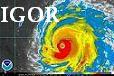
Hurricane Igor is the largest hurricane I believe I have ever seen. To think Igor can get even larger in the future blows my mind and reminds me of Super Typhoon Tip. How does it rank for largest Atlantic hurricanes? I would have thought someone would have the answer by now.
The other point I was going to make is this is the prime spot I think in the Atlantic to produce the largest hurricane possible because there isn't much landmass in the way and there is enough heat content to support it in Igor's current position. I had the idea this was where it might happen and funny enough it's coming true!
The other point I was going to make is this is the prime spot I think in the Atlantic to produce the largest hurricane possible because there isn't much landmass in the way and there is enough heat content to support it in Igor's current position. I had the idea this was where it might happen and funny enough it's coming true!
0 likes

Ya like I said, I believe hurricane Carla that hit Texas was bigger, but I don't know what other one you are referring to that would also go ahead of Igor
0 likes
2010 Archive: HURRICANE ALEX, TD TWO, TS BONNIE, TS COLIN, TD FIVE, HURRICANE DANIELLE, HURRICANE EARL, TS FIONA, TS GASTON, TS HERMINE, HURRICANE IGOR, HURRICANE JULIA, HURRICANE KARL, HURRICANE LISA, TS MATTHEW, TS NICOLE, HURRICANE OTTO, HURRICANE PAULA (Active)
-
Category 5

- Category 5

- Posts: 10074
- Age: 36
- Joined: Sun Feb 11, 2007 10:00 pm
- Location: New Brunswick, NJ
- Contact:
Re: ATL: IGOR - Hurricane - Discussion
The size of the storms CDO (not just the wind field) is just incredible for an Atlantic Hurricane.

0 likes

"GAME SET MATCH GIANTS WILL WIN THE NFC EAST and have a FIRST ROUND BYE with a win next week!!!" - StormingB81, the Giants lost, and did not win the NFC east.
-
Aric Dunn
- Category 5
- Posts: 21238
- Age: 43
- Joined: Sun Sep 19, 2004 9:58 pm
- Location: Ready for the Chase.
- Contact:
ok I have to say it.. its clearly moving W to wnw Right now.. and not just wobbling eye....
0 likes
Note: If I make a post that is brief. Please refer back to previous posts for the analysis or reasoning. I do not re-write/qoute what my initial post said each time.
If there is nothing before... then just ask
Space & Atmospheric Physicist, Embry-Riddle Aeronautical University,
I believe the sky is falling...
If there is nothing before... then just ask
Space & Atmospheric Physicist, Embry-Riddle Aeronautical University,
I believe the sky is falling...
I disagree Aric.. I think it is infact the "eye" bouncing around playing tricks on you.. If you look at the full view you can really tell.. http://www.ssd.noaa.gov/goes/east/tatl/flash-avn.html
0 likes
2010 Archive: HURRICANE ALEX, TD TWO, TS BONNIE, TS COLIN, TD FIVE, HURRICANE DANIELLE, HURRICANE EARL, TS FIONA, TS GASTON, TS HERMINE, HURRICANE IGOR, HURRICANE JULIA, HURRICANE KARL, HURRICANE LISA, TS MATTHEW, TS NICOLE, HURRICANE OTTO, HURRICANE PAULA (Active)
-
Aric Dunn
- Category 5
- Posts: 21238
- Age: 43
- Joined: Sun Sep 19, 2004 9:58 pm
- Location: Ready for the Chase.
- Contact:
Re:
canes101 wrote:I disagree Aric.. I think it is infact the "eye" bouncing around playing tricks on you.. If you look at the full view you can really tell.. http://www.ssd.noaa.gov/goes/east/tatl/flash-avn.html
well its clearly not 310 for the last few hours more 290.. 6 hour average has been NW... but not the last few hours..
0 likes
Note: If I make a post that is brief. Please refer back to previous posts for the analysis or reasoning. I do not re-write/qoute what my initial post said each time.
If there is nothing before... then just ask
Space & Atmospheric Physicist, Embry-Riddle Aeronautical University,
I believe the sky is falling...
If there is nothing before... then just ask
Space & Atmospheric Physicist, Embry-Riddle Aeronautical University,
I believe the sky is falling...
-
AussieMark

- Category 5
- Posts: 5857
- Joined: Tue Sep 02, 2003 6:36 pm
- Location: near Sydney, Australia
Re: Re:
Aric Dunn wrote:canes101 wrote:I disagree Aric.. I think it is infact the "eye" bouncing around playing tricks on you.. If you look at the full view you can really tell.. http://www.ssd.noaa.gov/goes/east/tatl/flash-avn.html
well its clearly not 310 for the last few hours more 290.. 6 hour average has been NW... but not the last few hours..
you saying it will miss Bermuda?
0 likes
No Aussie he isnt saying that. In fact more westward movements would be even worst for Bermuda
0 likes
2010 Archive: HURRICANE ALEX, TD TWO, TS BONNIE, TS COLIN, TD FIVE, HURRICANE DANIELLE, HURRICANE EARL, TS FIONA, TS GASTON, TS HERMINE, HURRICANE IGOR, HURRICANE JULIA, HURRICANE KARL, HURRICANE LISA, TS MATTHEW, TS NICOLE, HURRICANE OTTO, HURRICANE PAULA (Active)
-
Crostorm

- Category 5
- Posts: 2060
- Age: 51
- Joined: Mon Dec 25, 2006 3:51 pm
- Location: Croatia-Europe
- Contact:
000
WTNT31 KNHC 170833
TCPAT1
BULLETIN
HURRICANE IGOR ADVISORY NUMBER 37
NWS TPC/NATIONAL HURRICANE CENTER MIAMI FL AL112010
500 AM AST FRI SEP 17 2010
...DANGEROUS IGOR EXPECTED TO REMAIN A MAJOR HURRICANE FOR A COUPLE
MORE DAYS...
SUMMARY OF 500 AM AST...0900 UTC...INFORMATION
----------------------------------------------
LOCATION...22.4N 59.4W
ABOUT 760 MI...1225 KM SSE OF BERMUDA
ABOUT 375 MI...605 KM NE OF THE NORTHERN LEEWARD ISLANDS
MAXIMUM SUSTAINED WINDS...125 MPH...205 KM/HR
PRESENT MOVEMENT...NW OR 305 DEGREES AT 9 MPH...15 KM/HR
MINIMUM CENTRAL PRESSURE...935 MB...27.61 INCHES
WATCHES AND WARNINGS
--------------------
CHANGES WITH THIS ADVISORY...
NONE.
SUMMARY OF WATCHES AND WARNINGS IN EFFECT...
A HURRICANE WATCH IS IN EFFECT FOR...
* BERMUDA
A HURRICANE WATCH MEANS THAT HURRICANE CONDITIONS ARE POSSIBLE
WITHIN THE WATCH AREA. A WATCH IS TYPICALLY ISSUED 48 HOURS
BEFORE THE ANTICIPATED FIRST OCCURRENCE OF TROPICAL-STORM-FORCE
WINDS...CONDITIONS THAT MAKE OUTSIDE PREPARATIONS DIFFICULT OR
DANGEROUS.
FOR STORM INFORMATION SPECIFIC TO YOUR AREA...PLEASE MONITOR
PRODUCTS ISSUED BY YOUR NATIONAL METEOROLOGICAL SERVICE.
0 likes
Re: ATL: IGOR - Hurricane - Discussion
Zoomed in look at the track to see just what Bermuda is up against with Igor staying on its current track..

0 likes
2010 Archive: HURRICANE ALEX, TD TWO, TS BONNIE, TS COLIN, TD FIVE, HURRICANE DANIELLE, HURRICANE EARL, TS FIONA, TS GASTON, TS HERMINE, HURRICANE IGOR, HURRICANE JULIA, HURRICANE KARL, HURRICANE LISA, TS MATTHEW, TS NICOLE, HURRICANE OTTO, HURRICANE PAULA (Active)
-
lostinthetriangle
- Tropical Low

- Posts: 25
- Joined: Wed Sep 15, 2010 5:10 pm
- Location: Bermuda
Re: ATL: IGOR - Hurricane - Discussion
canes101 wrote:Zoomed in look at the track to see just what Bermuda is up against with Igor staying on its current track..
Good morning all, that not at all what I wanted to see this morning! wonder what surprises Igor will have for us today?
0 likes
Re:
bob rulz wrote:It looks like Mother Nature has literally taken a hammer to Igor on the IR...
Yes she is looking a little sickly this morning....

Unless he is trying to tell us something?? Does the number 6 mean anything to anyone? lol
.
.
0 likes
2010 Archive: HURRICANE ALEX, TD TWO, TS BONNIE, TS COLIN, TD FIVE, HURRICANE DANIELLE, HURRICANE EARL, TS FIONA, TS GASTON, TS HERMINE, HURRICANE IGOR, HURRICANE JULIA, HURRICANE KARL, HURRICANE LISA, TS MATTHEW, TS NICOLE, HURRICANE OTTO, HURRICANE PAULA (Active)
Who is online
Users browsing this forum: No registered users and 34 guests