Look at the graph though! Amazing what a hurricane can do when it passes directly over a weather station.
ATL: IGOR - Ex Hurricane - Discussion
Moderator: S2k Moderators
-
brunota2003

- S2K Supporter

- Posts: 9476
- Age: 35
- Joined: Sat Jul 30, 2005 9:56 pm
- Location: Stanton, KY...formerly Havelock, NC
- Contact:

Re: ATL: IGOR - Hurricane - Discussion
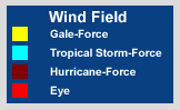
Just look how Igor's wind-field continues to grow.. Just amazing.
ONE:

TWO:

THREE:

KEY:
ONE:
TWO:
THREE:
KEY:
0 likes
2010 Archive: HURRICANE ALEX, TD TWO, TS BONNIE, TS COLIN, TD FIVE, HURRICANE DANIELLE, HURRICANE EARL, TS FIONA, TS GASTON, TS HERMINE, HURRICANE IGOR, HURRICANE JULIA, HURRICANE KARL, HURRICANE LISA, TS MATTHEW, TS NICOLE, HURRICANE OTTO, HURRICANE PAULA (Active)

-
dexterlabio
- Category 5

- Posts: 3517
- Joined: Sat Oct 24, 2009 11:50 pm
Re: ATL: IGOR - Hurricane - Discussion
How does Igor's eye look right now? I was expecting a large eye after the EWRC but the latest satpics I've seen show a small eye.
0 likes
Personal Forecast Disclaimer:
The posts in this forum are NOT official forecast and should not be used as such. They are just the opinion of the poster and may or may not be backed by sound meteorological data. They are NOT endorsed by any professional institution or storm2k.org. For official information, please refer to the NHC and NWS products.
The posts in this forum are NOT official forecast and should not be used as such. They are just the opinion of the poster and may or may not be backed by sound meteorological data. They are NOT endorsed by any professional institution or storm2k.org. For official information, please refer to the NHC and NWS products.
-
SouthFloridawx

- S2K Supporter
- Posts: 8346
- Age: 47
- Joined: Tue Jul 26, 2005 1:16 am
- Location: Sarasota, FL
- Contact:

-
cycloneye

- Admin

- Posts: 149727
- Age: 69
- Joined: Thu Oct 10, 2002 10:54 am
- Location: San Juan, Puerto Rico
Re: ATL: IGOR - Hurricane - Discussion
Hurricane Watch issued for Bermuda
SUMMARY OF 1100 PM AST...0300 UTC...INFORMATION
-----------------------------------------------
LOCATION...22.0N 58.7W
ABOUT 390 MI...625 KM NE OF THE NORTHERN LEEWARD ISLANDS
ABOUT 805 MI...1295 KM SSE OF BERMUDA
MAXIMUM SUSTAINED WINDS...125 MPH...205 KM/HR
PRESENT MOVEMENT...NW OR 310 DEGREES AT 9 MPH...15 KM/HR
MINIMUM CENTRAL PRESSURE...935 MB...27.61 INCHES
WATCHES AND WARNINGS
--------------------
CHANGES WITH THIS ADVISORY...
THE WEATHER SERVICE OF BERMUDA HAS ISSUED A HURRICANE WATCH FOR
BERMUDA.
SUMMARY OF WATCHES AND WARNINGS IN EFFECT...
A HURRICANE WATCH IS IN EFFECT FOR...
* BERMUDA
A HURRICANE WATCH MEANS THAT HURRICANE CONDITIONS ARE POSSIBLE
WITHIN THE WATCH AREA. A WATCH IS TYPICALLY ISSUED 48 HOURS
BEFORE THE ANTICIPATED FIRST OCCURRENCE OF TROPICAL-STORM-FORCE
WINDS...CONDITIONS THAT MAKE OUTSIDE PREPARATIONS DIFFICULT OR
DANGEROUS.
FOR STORM INFORMATION SPECIFIC TO YOUR AREA...PLEASE MONITOR
PRODUCTS ISSUED BY YOUR NATIONAL METEOROLOGICAL SERVICE.
0 likes
Visit the Caribbean-Central America Weather Thread where you can find at first post web cams,radars
and observations from Caribbean basin members Click Here
and observations from Caribbean basin members Click Here
-
brunota2003
- S2K Supporter
- Posts: 9476
- Age: 35
- Joined: Sat Jul 30, 2005 9:56 pm
- Location: Stanton, KY...formerly Havelock, NC
- Contact:
Re: ATL: IGOR - Hurricane - Discussion
I'm surprised no one mentioned the NHC's shout out to NOAA Buoy 41044:
...IGOR PASSES OVER NOAA BUOY...GOOD DATA COLLECTED...
HURRICANE FORCE WINDS EXTEND OUTWARD UP TO 105 MILES...165 KM...FROM
THE CENTER...AND TROPICAL STORM FORCE WINDS EXTEND OUTWARD UP TO 290
MILES...465 KM. IGOR PASSED NEAR NOAA BUOY 41044 AND REPORTED
SUSTAINED WINDS OF 79 MPH...128 KM/HR....WITH GUSTS TO 105 MPH...
169 KM/HR DURING THE PAST COUPLE OF HOURS.
THE MINIMUM CENTRAL PRESSURE ESTIMATED FROM DATA FROM THE NOAA BUOY
IS 935 MB...27.61 INCHES.
THE CLOUD PATTERN OF IGOR HAS CHANGED LITTLE THIS EVENING. DVORAK
CURRENT INTENSITY NUMBERS FROM SAB AND TAFB ARE 5.5 AND 6.0...
RESPECTIVELY. THIS SUPPORTS MAINTAINING AN INITIAL INTENSITY OF
110 KT. THE EYE OF IGOR IS PASSING VERY NEAR NOAA BUOY 41044.
THROUGH 0200 UTC...THE 5-METER HIGH ANEMOMETER ON THE BUOY HAS
REPORTED PEAK 1-MINUTE SUSTAINED WINDS OF 69 KT WITH A GUST TO 91
KT. A MINIMUM PRESSURE OF 940.3 MB WAS RECORDED AT 0050 UTC WITH
WINDS AROUND 60 KT. THIS SUGGESTS THAT THE MINIMUM PRESSURE IS
AROUND 935 MB. DUE TO THE LARGE SIZE AND RELATIVELY SLOW MOTION OF
THE HURRICANE...THE BUOY HAS NOW REPORTED TROPICAL STORM FORCE
WINDS FOR 21 CONSECUTIVE HOURS.
...IGOR PASSES OVER NOAA BUOY...GOOD DATA COLLECTED...
HURRICANE FORCE WINDS EXTEND OUTWARD UP TO 105 MILES...165 KM...FROM
THE CENTER...AND TROPICAL STORM FORCE WINDS EXTEND OUTWARD UP TO 290
MILES...465 KM. IGOR PASSED NEAR NOAA BUOY 41044 AND REPORTED
SUSTAINED WINDS OF 79 MPH...128 KM/HR....WITH GUSTS TO 105 MPH...
169 KM/HR DURING THE PAST COUPLE OF HOURS.
THE MINIMUM CENTRAL PRESSURE ESTIMATED FROM DATA FROM THE NOAA BUOY
IS 935 MB...27.61 INCHES.
0 likes

310 degrees they must be averaging over 6 hours? Those last couple of frames must have been a west wobble maybe Igor is getting ready for an EWRC or something.
Last edited by Nimbus on Thu Sep 16, 2010 10:12 pm, edited 1 time in total.
0 likes
-
SouthFloridawx
- S2K Supporter
- Posts: 8346
- Age: 47
- Joined: Tue Jul 26, 2005 1:16 am
- Location: Sarasota, FL
- Contact:

-
hurricaneCW
- Category 5
- Posts: 1799
- Joined: Wed Mar 03, 2010 6:20 am
- Location: Toms River, NJ
Re: ATL: IGOR - Hurricane - Discussion
Igor looks like he could eat both Karl and Julia at the same time. I mean the comparison, size wise, is insane.
0 likes
-
Windtalker1

- S2K Supporter
- Posts: 523
- Age: 37
- Joined: Sun Jul 31, 2005 11:00 am
- Location: Mesa, Arizona
Re: ATL: IGOR - Hurricane - Discussion
Looks like the last 6 frames of this loop is due west. What a wobble.
http://www.ssd.noaa.gov/goes/flt/t1/loop-ft.html
http://www.ssd.noaa.gov/goes/flt/t1/loop-ft.html
0 likes
Re: ATL: IGOR - Hurricane - Discussion
I figured it out Igor and Julia the raging russian couple.......
0 likes

Re: ATL: IGOR - Hurricane - Discussion
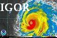
Igor must be one of the largest hurricanes ever in terms of TS force winds area and the size of the cloud field as well, what an interesting hurricane looks more like a WPAC typhoon.
0 likes

-
brunota2003
- S2K Supporter
- Posts: 9476
- Age: 35
- Joined: Sat Jul 30, 2005 9:56 pm
- Location: Stanton, KY...formerly Havelock, NC
- Contact:
I cannot believe the buoy is still transmitting! Pressures are on the rise now, with it bottoming out at 942 millibars (possibly lower, the NHC said 940.3, but there is data missing on the website). This buoy should be retired and replaced with a new one for doing it's job so well! It has survived, thus far, an incredible beating and keeps on ticking.
0 likes
Re: ATL: IGOR - Hurricane - Discussion
Macrocane wrote:Igor must be one of the largest hurricanes ever in terms of TS force winds area and the size of the cloud field as well, what an interesting hurricane looks more like a WPAC typhoon.
I'm not sure where Igor would rank but I would tend to agree with you that Igor must be up near the top somewheres... I have posted this wind-field image a few times today because it just blows my mind how much it has expanded..

I know as far as Typhoons go, Typhoon Tip was the Largest ever.. It had a diameter of 2,220 km (1,380 mi) Thats NUTS. Not only was it the Largest cyclone ever it was also the most powerful. I believe it had max sustained winds of 190mph and a Pressure of 870
Another Huge hurricane was hurricane Carla that hit the Texas coast in 1961.
Last edited by canes101 on Thu Sep 16, 2010 10:33 pm, edited 1 time in total.
0 likes
2010 Archive: HURRICANE ALEX, TD TWO, TS BONNIE, TS COLIN, TD FIVE, HURRICANE DANIELLE, HURRICANE EARL, TS FIONA, TS GASTON, TS HERMINE, HURRICANE IGOR, HURRICANE JULIA, HURRICANE KARL, HURRICANE LISA, TS MATTHEW, TS NICOLE, HURRICANE OTTO, HURRICANE PAULA (Active)

Re:
NHC wrote:THE BUOY HAS NOW REPORTED TROPICAL STORM FORCE
WINDS FOR 21 CONSECUTIVE HOURS.
Just crazy and its only just now starting to ramp down correct? So many more hours to come I believe.
0 likes
2010 Archive: HURRICANE ALEX, TD TWO, TS BONNIE, TS COLIN, TD FIVE, HURRICANE DANIELLE, HURRICANE EARL, TS FIONA, TS GASTON, TS HERMINE, HURRICANE IGOR, HURRICANE JULIA, HURRICANE KARL, HURRICANE LISA, TS MATTHEW, TS NICOLE, HURRICANE OTTO, HURRICANE PAULA (Active)
Re:
RL3AO wrote:Heres what Igor would look like in the GOM for size comparisons.Code: Select all
[img]http://i54.tinypic.com/2edr57a.jpg[/img]
And yes those are the Antillies in the BOC. I didn't want to take that long making the image.
LOL
0 likes
2010 Archive: HURRICANE ALEX, TD TWO, TS BONNIE, TS COLIN, TD FIVE, HURRICANE DANIELLE, HURRICANE EARL, TS FIONA, TS GASTON, TS HERMINE, HURRICANE IGOR, HURRICANE JULIA, HURRICANE KARL, HURRICANE LISA, TS MATTHEW, TS NICOLE, HURRICANE OTTO, HURRICANE PAULA (Active)
Who is online
Users browsing this forum: No registered users and 35 guests