ATL: IGOR - Ex Hurricane - Discussion
Moderator: S2k Moderators
-
hurricaneCW
- Category 5

- Posts: 1799
- Joined: Wed Mar 03, 2010 6:20 am
- Location: Toms River, NJ
Re: ATL: Tropical Storm IGOR - Discussion
Igor has a very large circulation which means that it will likely be a huge system. It will be interesting to see how large and strong it gets.
0 likes
-
Dean4Storms
- S2K Supporter

- Posts: 6358
- Age: 63
- Joined: Sun Aug 31, 2003 1:01 pm
- Location: Miramar Bch. FL
Re: ATL: Tropical Storm IGOR - Discussion
wxman57 wrote:In all of recorded history (since 1851), no storm passing within 115 miles north or south of Igor's current position has ever come within even 150 miles of the NE Caribbean. Luis (1995) was way down by 14N at 38W. Odds of a NE Caribbean hit are low. Not impossible, of course. I'd pay attention if I was living in the NE Caribbean. Kind of like standing on train tracks just beyond the switching point with a big train coming. Yeah, you know the switch will probably be thrown to turn the train away, but do you just stand there looking?
Good comparison! LOL!
0 likes
-
cycloneye

- Admin

- Posts: 149735
- Age: 69
- Joined: Thu Oct 10, 2002 10:54 am
- Location: San Juan, Puerto Rico
Re: ATL: Tropical Storm IGOR - Discussion

0 likes
Visit the Caribbean-Central America Weather Thread where you can find at first post web cams,radars
and observations from Caribbean basin members Click Here
and observations from Caribbean basin members Click Here
-
cycloneye
- Admin
- Posts: 149735
- Age: 69
- Joined: Thu Oct 10, 2002 10:54 am
- Location: San Juan, Puerto Rico
Re: ATL: Tropical Storm IGOR - Discussion
The latest at 15:15z.

0 likes
Visit the Caribbean-Central America Weather Thread where you can find at first post web cams,radars
and observations from Caribbean basin members Click Here
and observations from Caribbean basin members Click Here
-
gatorcane

- S2K Supporter
- Posts: 23708
- Age: 48
- Joined: Sun Mar 13, 2005 3:54 pm
- Location: Boca Raton, FL
Re: ATL: Tropical Storm IGOR - Discussion
Dean4Storms wrote:wxman57 wrote:In all of recorded history (since 1851), no storm passing within 115 miles north or south of Igor's current position has ever come within even 150 miles of the NE Caribbean. Luis (1995) was way down by 14N at 38W. Odds of a NE Caribbean hit are low. Not impossible, of course. I'd pay attention if I was living in the NE Caribbean. Kind of like standing on train tracks just beyond the switching point with a big train coming. Yeah, you know the switch will probably be thrown to turn the train away, but do you just stand there looking?
Good comparison! LOL!
Models are shifting to the east. Looks like the nhc track may need an eastward adjustment at 5pm. The gfdl and hwrf will determine if the shift happens.
0 likes


Re: ATL: Tropical Storm IGOR - Discussion
gatorcane wrote:
Models are shifting to the east. Looks like the nhc track may need an eastward adjustment at 5pm. The gfdl and hwrf will determine if the shift happens.
Which ones? The 12Z GFS is marginally to the west of the 6Z, the 12Z nogaps looks about the same as the 6Z, and the CMC hardly looks shifted to the east, maybe west.
0 likes


-
neospaceblue
- Tropical Storm

- Posts: 112
- Age: 32
- Joined: Fri Aug 10, 2007 3:17 pm
- Location: Newport News, VA
Re:
Shuriken wrote:Here's hoping for a big, photogenic annular 'cane with eye votices.
Especially one that stays out to sea. I mean, we haven't had a Category 5 fish storm in about 5 decades, and it would be nice to have a satellite view of one.
0 likes
-
cycloneye
- Admin
- Posts: 149735
- Age: 69
- Joined: Thu Oct 10, 2002 10:54 am
- Location: San Juan, Puerto Rico
Re: ATL: Tropical Storm IGOR - Discussion
18z Best Track
AL, 11, 2010091118, , BEST, 0, 174N, 404W, 60, 995, TS
ftp://ftp.tpc.ncep.noaa.gov/atcf/tcweb/ ... 010.invest
Not a hurricane yet.
AL, 11, 2010091118, , BEST, 0, 174N, 404W, 60, 995, TS
ftp://ftp.tpc.ncep.noaa.gov/atcf/tcweb/ ... 010.invest
Not a hurricane yet.
0 likes
Visit the Caribbean-Central America Weather Thread where you can find at first post web cams,radars
and observations from Caribbean basin members Click Here
and observations from Caribbean basin members Click Here

Re: ATL: Tropical Storm IGOR - Discussion
The tropical update on the TWC says Igor will follow a similar path as Earl and will probably have an impact on Canada.
0 likes
-
bvigal

- S2K Supporter
- Posts: 2276
- Joined: Sun Jul 24, 2005 8:49 am
- Location: British Virgin Islands
- Contact:
Re: ATL: Tropical Storm IGOR - Discussion
wxman57 wrote:In all of recorded history (since 1851), no storm passing within 115 miles north or south of Igor's current position has ever come within even 150 miles of the NE Caribbean. Luis (1995) was way down by 14N at 38W. Odds of a NE Caribbean hit are low. Not impossible, of course. I'd pay attention if I was living in the NE Caribbean. Kind of like standing on train tracks just beyond the switching point with a big train coming. Yeah, you know the switch will probably be thrown to turn the train away, but do you just stand there looking?
I LOVE your analogy wxman57, it's simply brilliant!!! If Igor becomes the size and intensity current knowledge tends to indicate, it would be foolish to ignore him assuming that turn will happen in time! If it takes 2 days to get ready and by two days out the turn isn't evident, then it would make sense to "get off the tracks," LOL!
0 likes

Re: ATL: Tropical Storm IGOR - Discussion
TWC has such bad comedy when Norcross is not there....God Bless John Hope...Miss that gentleman 
0 likes
-
Aquawind

- Category 5
- Posts: 6714
- Age: 62
- Joined: Mon Jun 16, 2003 10:41 pm
- Location: Salisbury, NC
- Contact:
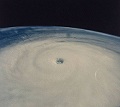
Now that's some good convection firing over the center..healthy looking core as well.
http://www.ssd.noaa.gov/goes/flt/t1/flash-bd.html
http://www.ssd.noaa.gov/goes/flt/t1/flash-bd.html
0 likes
-
cycloneye
- Admin
- Posts: 149735
- Age: 69
- Joined: Thu Oct 10, 2002 10:54 am
- Location: San Juan, Puerto Rico
Re: ATL: Tropical Storm IGOR - Discussion
5 PM Forecast track.

0 likes
Visit the Caribbean-Central America Weather Thread where you can find at first post web cams,radars
and observations from Caribbean basin members Click Here
and observations from Caribbean basin members Click Here


>>The tropical update on the TWC says Igor will follow a similar path as Earl and will probably have an impact on Canada.
I like that idea but maybe a hair east? SW Atlantic is supplying the juice this year for the big dog storms. Too early to guess how close it comes to the NC coast. It looks like the model consensus (minus a couple of BAM's and the UKMET) want to bring it up around 65W. They did that with Earl as well. The difference between Igor and Earl is that the weakness is transient for Igor. If he catches it, he's probably out to sea quickly. If not, the high coming off the SE Coast is progged a little quicker in relation to the storm than Earl. It is my personal guess that he'll have enough latitude to not really bother the east coast (rip tides, surf and gradient wind excluded) but there is a reasonable chance he could get west of 70 and scare some people. I'd put it at about 30% that he makes 70W. And if he gets there, there is a slight chance for the trap or a temporary stall depending. I think the following high will be a little stronger as you can see some of the pressure rising up in Northern Canada with shots coming through the Northern Plains and down off the Mid-Atlantic Coast (weaker, but 2005esque for the first time this season).
(i.e. 12z GFS http://moe.met.fsu.edu/cgi-bin/gfstc2.c ... =Animation )
^^^^^^^^^^^
Personal Forecast Disclaimer: What you read are some ramblings of the poster only and not to be considered anything else.
0 likes
-
hurricaneCW
- Category 5
- Posts: 1799
- Joined: Wed Mar 03, 2010 6:20 am
- Location: Toms River, NJ
Re: ATL: Tropical Storm IGOR - Discussion
Interestingly enough, the NAO is heading more positive right now and it should be on the positive side by either Sunday or Monday. The NAO was quite negative with Earl but the more positive NAO definitely means less troughiness. It also appears that the NAO could stay more on the positive side throughout the 2nd half of September meaning more western Atlantic ridging. So instead of the typical late September, October increased troughiness, we're likely to see more ridging than we have seen for over a month. This will increase the chance of future Cape Verde storms coming closer to the U.S. The current one off the coast of Africa is going to be playing in completely different dynamics.
It's sort of like the whole Earl and Fiona situation, Igor will be the larger and stronger of the two, it will help create a weakness, a more sheared environment so the storm after Igor will obviously head more north and east of Igor. The Cape Verde storms after 93L are going to be the ones to watch after Igor is done with his trip across the Atlantic. I'm very confident that Igor curves out between 60-70W, he's too far north right now, there is still a lot of western Atlantic troughiness and the ridge coming off the U.S. will probably not come out in time to block the northward turn.
It's sort of like the whole Earl and Fiona situation, Igor will be the larger and stronger of the two, it will help create a weakness, a more sheared environment so the storm after Igor will obviously head more north and east of Igor. The Cape Verde storms after 93L are going to be the ones to watch after Igor is done with his trip across the Atlantic. I'm very confident that Igor curves out between 60-70W, he's too far north right now, there is still a lot of western Atlantic troughiness and the ridge coming off the U.S. will probably not come out in time to block the northward turn.
0 likes
Who is online
Users browsing this forum: No registered users and 52 guests