ATL: Ex-Tropical Storm HERMINE - Discussion
Moderator: S2k Moderators
-
cwachal
-
PauleinHouston
- Tropical Storm

- Posts: 102
- Joined: Mon Aug 13, 2007 10:23 am
- Location: League City, TX
- Contact:
Re: ATL: Tropical Storm HERMINE - Discussion
wxman57 wrote:I think Hurricane Hermine will move ashore just north of Brownsville tomorrow morning. Fairly confident landfall won't be north of Corpus.
Agreed on that one. You see an upgrade coming at next update or an interim? Recon should be there in what, about an hour?
0 likes
The posts in this forum are NOT official forecasts and should not be used as such. They are just the opinion of this amateur poster and may or may not be backed by sound meteorological data. They are NOT endorsed by any professional institution or storm2k.org. For official information, please refer to NWS products.
-
CrazyC83
- Professional-Met

- Posts: 34316
- Joined: Tue Mar 07, 2006 11:57 pm
- Location: Deep South, for the first time!
Personal Forecast Disclaimer:
The posts in this forum are NOT official forecast and should not be used as such. They are just the opinion of the poster and may or may not be backed by sound meteorological data. They are NOT endorsed by any professional institution or storm2k.org. For official information, please refer to the NHC and NWS products.
Depending on what Recon finds, I would seriously look at a Hurricane Watch or Warning for the area around the Rio Grande.
0 likes

Re: ATL: Tropical Storm HERMINE - Discussion
CrazyC83 wrote:Personal Forecast Disclaimer:
The posts in this forum are NOT official forecast and should not be used as such. They are just the opinion of the poster and may or may not be backed by sound meteorological data. They are NOT endorsed by any professional institution or storm2k.org. For official information, please refer to the NHC and NWS products.
Depending on what Recon finds, I would seriously look at a Hurricane Watch or Warning for the area around the Rio Grande.
Given the landfall timeframe, wouldn't a warning be more appropriate, if there was a solid chance that it would attain hurricane intensity?
In any case, people along the valley and need to be preparing, and those on South Padre probably want to make their way to the mainland.
0 likes

-
CrazyC83
- Professional-Met
- Posts: 34316
- Joined: Tue Mar 07, 2006 11:57 pm
- Location: Deep South, for the first time!
Re: ATL: Tropical Storm HERMINE - Discussion
BigA wrote:CrazyC83 wrote:Personal Forecast Disclaimer:
The posts in this forum are NOT official forecast and should not be used as such. They are just the opinion of the poster and may or may not be backed by sound meteorological data. They are NOT endorsed by any professional institution or storm2k.org. For official information, please refer to the NHC and NWS products.
Depending on what Recon finds, I would seriously look at a Hurricane Watch or Warning for the area around the Rio Grande.
Given the landfall timeframe, wouldn't a warning be more appropriate, if there was a solid chance that it would attain hurricane intensity?
In any case, people along the valley and need to be preparing, and those on South Padre probably want to make their way to the mainland.
Watch would be if the forecast is under hurricane intensity but with a chance of reaching it (alongside the TS Warning). Warning would be if the forecast is for 65 kt or greater.
0 likes

Re:
New advisory in less than 40 minutes....i would expect we will be seeing a very proactive NHC with the new advisory...
RL3AO wrote:I wish the NHC would be a little more proactive in these situations and issue a hurricane watch.
0 likes
-
srainhoutx

- S2K Supporter

- Posts: 6919
- Age: 68
- Joined: Sun Jan 14, 2007 11:34 am
- Location: Haywood County, NC
- Contact:
Re: ATL: Tropical Storm HERMINE - Discussion
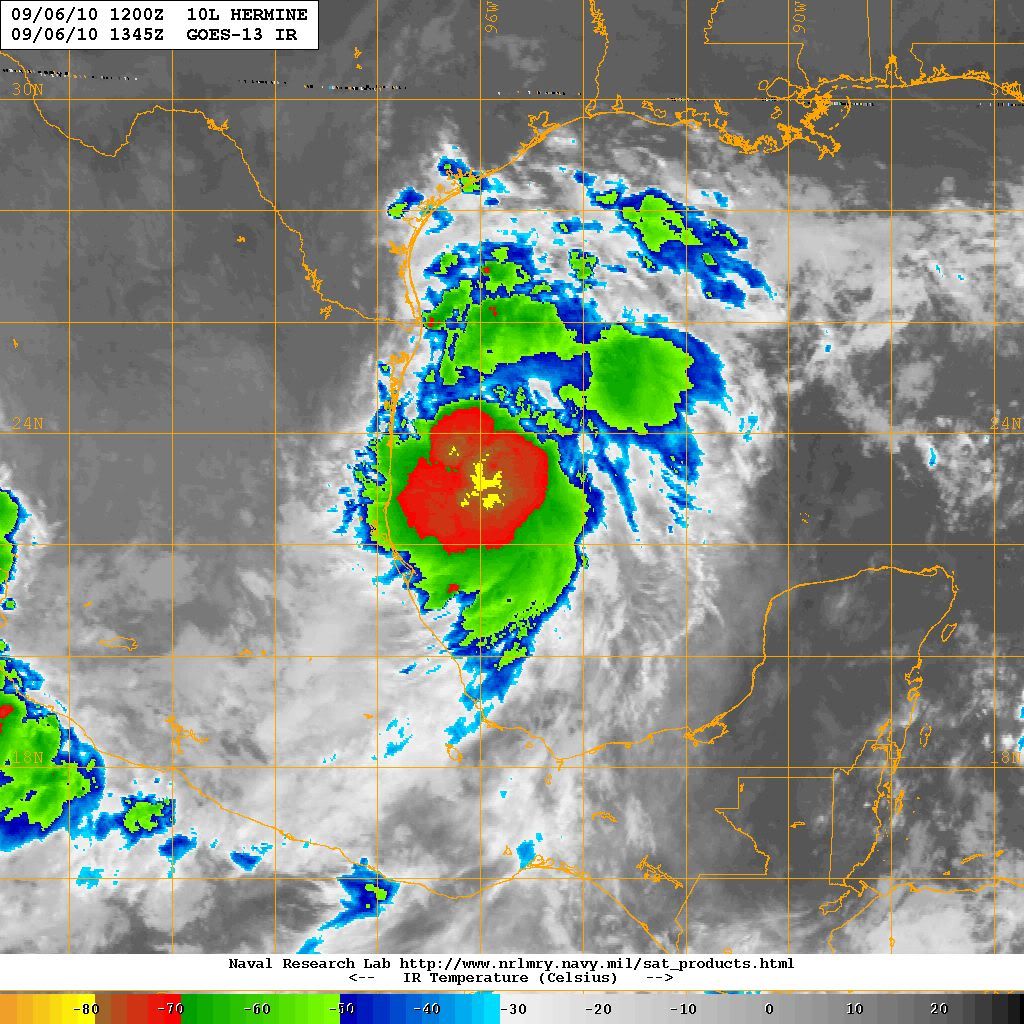
Some mighty cold cloud tops S of the center...
0 likes
Carla/Alicia/Jerry(In The Eye)/Michelle/Charley/Ivan/Dennis/Katrina/Rita/Wilma/Ike/Harvey
Member: National Weather Association
Wx Infinity Forums
http://wxinfinity.com/index.php
Facebook.com/WeatherInfinity
Twitter @WeatherInfinity
Member: National Weather Association
Wx Infinity Forums
http://wxinfinity.com/index.php
Facebook.com/WeatherInfinity
Twitter @WeatherInfinity
-
PauleinHouston
- Tropical Storm
- Posts: 102
- Joined: Mon Aug 13, 2007 10:23 am
- Location: League City, TX
- Contact:
Re: ATL: Tropical Storm HERMINE - Discussion
I know it's a long shot, but anyone want to chime in on whether or not BRO radar is seeing the center of circ?
http://radar.weather.gov/radar.php?rid=BRO&product=N0Z&overlay=11101111&loop=yes
http://radar.weather.gov/radar.php?rid=BRO&product=N0Z&overlay=11101111&loop=yes
Last edited by PauleinHouston on Mon Sep 06, 2010 9:28 am, edited 1 time in total.
0 likes
The posts in this forum are NOT official forecasts and should not be used as such. They are just the opinion of this amateur poster and may or may not be backed by sound meteorological data. They are NOT endorsed by any professional institution or storm2k.org. For official information, please refer to NWS products.

Re: ATL: Tropical Storm HERMINE - Discussion
wxman57 wrote:I think Hurricane Hermine will move ashore just north of Brownsville tomorrow morning. Fairly confident landfall won't be north of Corpus.
Well, if we are going to have a US landfall, that's the place to do it...Kenedy County...population 388.
Last edited by HurrMark on Mon Sep 06, 2010 9:28 am, edited 1 time in total.
0 likes


Re: ATL: Tropical Storm HERMINE - Discussion
srainhoutx wrote:Some mighty cold cloud tops S of the center...
strainhoutx does Hermine bring back memories of Bret, if memory serves me right he was forecasted to make a turn much sooner than he actually did.
0 likes
-
srainhoutx
- S2K Supporter
- Posts: 6919
- Age: 68
- Joined: Sun Jan 14, 2007 11:34 am
- Location: Haywood County, NC
- Contact:
Re: ATL: Tropical Storm HERMINE - Discussion
perk wrote:srainhoutx wrote:Some mighty cold cloud tops S of the center...
strainhoutx does Hermine bring back memories of Bret, if memory serves me right he was forecasted to make a turn much sooner than he actually did.
It certainly does perk. I don't think Hermine will get that strong, but with what we are seeing this morning, it does raise an eyebrow.
0 likes
Carla/Alicia/Jerry(In The Eye)/Michelle/Charley/Ivan/Dennis/Katrina/Rita/Wilma/Ike/Harvey
Member: National Weather Association
Wx Infinity Forums
http://wxinfinity.com/index.php
Facebook.com/WeatherInfinity
Twitter @WeatherInfinity
Member: National Weather Association
Wx Infinity Forums
http://wxinfinity.com/index.php
Facebook.com/WeatherInfinity
Twitter @WeatherInfinity
-
redfish1
- Tropical Storm
- Posts: 125
- Age: 45
- Joined: Thu Jun 17, 2010 9:24 pm
- Location: Port Arthur, Tx
Re: ATL: Tropical Storm HERMINE - Discussion
is it possible it stays on a northerly track rather than turning towards the west?
0 likes
Re: ATL: Tropical Storm HERMINE - Discussion
TROPICAL STORM HERMINE FORECAST/ADVISORY NUMBER 3
NWS TPC/NATIONAL HURRICANE CENTER MIAMI FL AL102010
1500 UTC MON SEP 06 2010
CHANGES IN WATCHES AND WARNINGS WITH THIS ADVISORY...
THE GOVERNMENT OF MEXICO HAS ISSUED A HURRICANE WATCH FROM RIO SAN
FERNANDO NORTHWARD TO THE MOUTH OF THE RIO GRANDE...AND A HURRICANE
WATCH HAS BEEN ISSUED FROM THE MOUTH OF THE RIO GRANDE NORTHWARD TO
BAFFIN BAY TEXAS.
THE TROPICAL STORM WARNING HAS BEEN EXTENDED NORTHWARD TO PORT
OCONNOR.
THE GOVERNMENT OF MEXICO HAS DISCONTINUED THE TROPICAL STORM WARNING
SOUTH OF LA CRUZ.
SUMMARY OF WATCHES AND WARNINGS IN EFFECT...
A HURRICANE WATCH IS IN EFFECT FOR...
* RIO SAN FERNANDO MEXICO NORTHWARD TO BAFFIN BAY TEXAS
A TROPICAL STORM WARNING IS IN EFFECT FOR...
* LA CRUZ MEXICO NORTHWARD TO PORT OCONNOR TEXAS
A HURRICANE WATCH MEANS THAT HURRICANE CONDITIONS ARE POSSIBLE
WITHIN THE WATCH AREA...IN THIS CASE WITHIN ABOUT 24 HOURS.
A TROPICAL STORM WARNING MEANS THAT TROPICAL STORM CONDITIONS ARE
EXPECTED SOMEWHERE WITHIN THE WARNING AREA...IN THIS CASE WITHIN
ABOUT 24 HOURS.
TROPICAL STORM CENTER LOCATED NEAR 23.4N 95.8W AT 06/1500Z
POSITION ACCURATE WITHIN 30 NM
PRESENT MOVEMENT TOWARD THE NORTH-NORTHWEST OR 340 DEGREES AT 11 KT
ESTIMATED MINIMUM CENTRAL PRESSURE 998 MB
MAX SUSTAINED WINDS 45 KT WITH GUSTS TO 55 KT.
34 KT....... 90NE 90SE 0SW 30NW.
12 FT SEAS..150NE 60SE 0SW 30NW.
WINDS AND SEAS VARY GREATLY IN EACH QUADRANT. RADII IN NAUTICAL
MILES ARE THE LARGEST RADII EXPECTED ANYWHERE IN THAT QUADRANT.
0 likes

Somewhere close to the border sounds a good call tomorrow night and as Wxman57 said probably a hurricane as well...that area doesn't need even a TS yet alone a hurricane!
Recon probably going to find a strengthening system...looking very impressive now and hurricane warnings are almost certainly needed IMO.
Recon probably going to find a strengthening system...looking very impressive now and hurricane warnings are almost certainly needed IMO.
0 likes
Personal Forecast Disclaimer:
The posts in this forum are NOT official forecast and should not be used as such. They are just the opinion of the poster and may or may not be backed by sound meteorological data. They are NOT endorsed by any professional institution or storm2k.org. For official information, please refer to the NHC and NWS products
The posts in this forum are NOT official forecast and should not be used as such. They are just the opinion of the poster and may or may not be backed by sound meteorological data. They are NOT endorsed by any professional institution or storm2k.org. For official information, please refer to the NHC and NWS products
-
cycloneye

- Admin

- Posts: 149727
- Age: 69
- Joined: Thu Oct 10, 2002 10:54 am
- Location: San Juan, Puerto Rico
Re: ATL: Tropical Storm HERMINE - Discussion

0 likes
Visit the Caribbean-Central America Weather Thread where you can find at first post web cams,radars
and observations from Caribbean basin members Click Here
and observations from Caribbean basin members Click Here

Re: ATL: Tropical Storm HERMINE - Discussion
HurrMark wrote:wxman57 wrote:I think Hurricane Hermine will move ashore just north of Brownsville tomorrow morning. Fairly confident landfall won't be north of Corpus.
Well, if we are going to have a US landfall, that's the place to do it...Kenedy County...population 388.
Wow! I think most of us here were looking thousands of miles away in the Atlantic, checking out SAL and anything else, every once in while one of the models would show something in the western gulf but we'd say what is that and ignore it, but lo and behold something forms out of nowhere right under our noses, crazy
0 likes
Who is online
Users browsing this forum: No registered users and 34 guests