ATL: FIONA - Models

Moderator: S2k Moderators

Message
Author
jaxfladude
Category 5
Category 5
Posts: 1249
Joined: Wed Aug 24, 2005 9:36 pm
Location: Jacksonville, Fla

Re: ATL: 97L - Models

#301 Postby jaxfladude » Sat Aug 28, 2010 3:58 pm

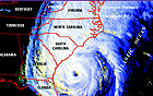
wxman57 wrote:European doesn't like Charleston:
http://raleighwx.easternuswx.com/models ... _loop.html


Even my area may feel some nasty direct effects if that verifies, huge system!
0 likes   
Stay safe y'all

Ikester
Professional-Met
Professional-Met
Posts: 361
Age: 39
Joined: Mon Jun 21, 2010 5:00 pm
Location: Jacksonville, FL

Re: ATL: 97L - Models

#302 Postby Ikester » Sat Aug 28, 2010 4:01 pm

If it hit Jacksonville, that would be a horrifying scenario. Jacksonville is one of the few cities along hurricane prone US coastline that has NOT been hit by a hurricane in a VERY long time. Tampa being the other. I think the damage would be magnified in those areas and evacuations would be a nightmare.
0 likes   

User avatar
KWT
Category 5
Category 5
Posts: 31415
Joined: Tue Aug 17, 2004 11:02 am
Location: UK!!!

#303 Postby KWT » Sat Aug 28, 2010 4:06 pm

Going to be real tough to call this one because so much is going to hinge on how rapidly Earl can withdraw out of the way...the fact the NHC is going with a more westerly solution will give 97L more time to withdraw and recurve...but the models are suggesting an upper pattern that could threaten the east coast.

I've been quite concerned about this one in the last 24-36hrs and the ECM shows why...with Earl and future Fiona we may have several close calls!
0 likes   
Personal Forecast Disclaimer:
The posts in this forum are NOT official forecast and should not be used as such. They are just the opinion of the poster and may or may not be backed by sound meteorological data. They are NOT endorsed by any professional institution or storm2k.org. For official information, please refer to the NHC and NWS products

User avatar
ronjon
Category 5
Category 5
Posts: 4822
Joined: Fri Aug 19, 2005 5:17 pm
Location: Hernando Beach, FL

Re: ATL: 97L - Models

#304 Postby ronjon » Sat Aug 28, 2010 4:24 pm

12z ECM ensemble run at 240 hrs - quite a spread from the eastern GOM, FL peninsula, or SE coast.

Image
0 likes   

jaxfladude
Category 5
Category 5
Posts: 1249
Joined: Wed Aug 24, 2005 9:36 pm
Location: Jacksonville, Fla

Re: ATL: 97L - Models

#305 Postby jaxfladude » Sat Aug 28, 2010 4:26 pm

Ikester wrote:If it hit Jacksonville, that would be a horrifying scenario. Jacksonville is one of the few cities along hurricane prone US coastline that has NOT been hit by a hurricane in a VERY long time. Tampa being the other. I think the damage would be magnified in those areas and evacuations would be a nightmare.


1999's Floyd was an evacuation nightmare for sure The Fla to N.C. evacuations and the actual landfall well north of Florida, my area's coastline got brushed very good, the Pier at Jax Beach was damaged. Not to mention the horrible flooding that occurred in North Carolina
0 likes   
Stay safe y'all

User avatar
KWT
Category 5
Category 5
Posts: 31415
Joined: Tue Aug 17, 2004 11:02 am
Location: UK!!!

#306 Postby KWT » Sat Aug 28, 2010 4:27 pm

The thing that we can gleam from the ensembles though is there is very good support within the ECM own members of a large threat to the E.Coast somewhere...
0 likes   
Personal Forecast Disclaimer:
The posts in this forum are NOT official forecast and should not be used as such. They are just the opinion of the poster and may or may not be backed by sound meteorological data. They are NOT endorsed by any professional institution or storm2k.org. For official information, please refer to the NHC and NWS products

emeraldislencguy
S2K Supporter
S2K Supporter
Posts: 207
Joined: Sun Aug 27, 2006 4:35 pm
Location: emerald isle nc
Contact:

Re: ATL: 97L - Models

#307 Postby emeraldislencguy » Sat Aug 28, 2010 4:31 pm

a good time to review evacuation plans and to go over things you will need if a hurricane threatens your area. I know I am paying close attention to each and every advisory and model. Thanks to everyone who makes this site so relevant. I live about 75 yards from the ocean so I am really start to pay attention. :flag:
0 likes   

User avatar
ronjon
Category 5
Category 5
Posts: 4822
Joined: Fri Aug 19, 2005 5:17 pm
Location: Hernando Beach, FL

Re:

#308 Postby ronjon » Sat Aug 28, 2010 4:31 pm

KWT wrote:The thing that we can gleam from the ensembles though is there is very good support within the ECM own members of a large threat to the E.Coast somewhere...


Based on the ensemble run, KWT, I think it is entirely plausible for the system to even move west into FL or through the straits. Way out there but the trend appears to be more ridging so we'll see.
0 likes   

Danny MD
Tropical Low
Tropical Low
Posts: 19
Joined: Sat Aug 28, 2010 2:52 pm

Re: ATL: 97L - Models

#309 Postby Danny MD » Sat Aug 28, 2010 4:50 pm

Could this be like a hurricane isabel? Should the residents in the mid atlantic area be monitering this?


I mean this in regards to its effects(83 MPH gust in silver spring md, power out for a week+, sustained 45+ mph for hours..) to maryland around the Washington DC area.
0 likes   

User avatar
Vortex
S2K Supporter
S2K Supporter
Posts: 4644
Age: 53
Joined: Fri Aug 01, 2003 9:34 pm
Location: Hilton Head, SC

Re: ATL: 97L - Models

#310 Postby Vortex » Sat Aug 28, 2010 4:51 pm

A trend I've noticed is the Nogaps/CMC/GFS all indicate a wsw/sw movement of future fiona during the next few days..I've noticed this afternoon that the overall motion does appear to be 265-270...
0 likes   

User avatar
ROCK
Category 5
Category 5
Posts: 9484
Age: 54
Joined: Tue Aug 17, 2004 7:30 am
Location: Kemah, Texas

Re: Re:

#311 Postby ROCK » Sat Aug 28, 2010 4:52 pm

ronjon wrote:
KWT wrote:The thing that we can gleam from the ensembles though is there is very good support within the ECM own members of a large threat to the E.Coast somewhere...


Based on the ensemble run, KWT, I think it is entirely plausible for the system to even move west into FL or through the straits. Way out there but the trend appears to be more ridging so we'll see.


I agree...FL should be paying attention....
0 likes   

JPmia
S2K Supporter
S2K Supporter
Posts: 1070
Joined: Thu Jun 03, 2004 11:01 pm
Location: Fort Lauderdale, FL

Re: Re:

#312 Postby JPmia » Sat Aug 28, 2010 4:58 pm

ronjon wrote:
KWT wrote:The thing that we can gleam from the ensembles though is there is very good support within the ECM own members of a large threat to the E.Coast somewhere...


Based on the ensemble run, KWT, I think it is entirely plausible for the system to even move west into FL or through the straits. Way out there but the trend appears to be more ridging so we'll see.


Could one of you explain this ensemble? It shows multiple lows in the SW Atlantic. I don't understand that and the other models showing a specific storm.
0 likes   

User avatar
stormchazer
Category 5
Category 5
Posts: 2461
Joined: Fri Aug 29, 2003 12:00 pm
Location: Lakeland, Florida
Contact:

Re: ATL: 97L - Models

#313 Postby stormchazer » Sat Aug 28, 2010 5:01 pm

Danny MD wrote:Could this be like a hurricane isabel? Should the residents in the mid atlantic area be monitering this?


I mean this in regards to its effects(83 MPH gust in silver spring md, power out for a week+, sustained 45+ mph for hours..) to maryland around the Washington DC area.


Yes and yes. The Mid-Atlantic does need to pay attention. There is time and we do not even have an actual system yet but we have been in a "recurve" pattern. If we are seeing a pattern flip, and the NAO modeling has been hinting at this, then a recurve could occur much closer to the coast and in those cases, the outer banks and Mid-Atlantic are always at risk. People along the SE and Mid-Atl should all keep an eye.
0 likes   
The posts or stuff said are NOT an official forecast and my opinion alone. Please look to the NHC and NWS for official forecasts and products.

Model Runs Cheat Sheet:
GFS (5:30 AM/PM, 11:30 AM/PM)
HWRF, GFDL, UKMET, NAVGEM (6:30-8:00 AM/PM, 12:30-2:00 AM/PM)
ECMWF (1:45 AM/PM)
TCVN is a weighted averaged

Opinions my own.

User avatar
ROCK
Category 5
Category 5
Posts: 9484
Age: 54
Joined: Tue Aug 17, 2004 7:30 am
Location: Kemah, Texas

Re: ATL: 97L - Models

#314 Postby ROCK » Sat Aug 28, 2010 5:02 pm

Vortex wrote:A trend I've noticed is the Nogaps/CMC/GFS all indicate a wsw/sw movement of future fiona during the next few days..I've noticed this afternoon that the overall motion does appear to be 265-270...


http://cimss.ssec.wisc.edu/tropic/real- ... 8dlm1.html

yep...should be moving that way...for now
0 likes   

User avatar
KWT
Category 5
Category 5
Posts: 31415
Joined: Tue Aug 17, 2004 11:02 am
Location: UK!!!

Re: ATL: 97L - Models

#315 Postby KWT » Sat Aug 28, 2010 5:02 pm

Vortex wrote:A trend I've noticed is the Nogaps/CMC/GFS all indicate a wsw/sw movement of future fiona during the next few days..I've noticed this afternoon that the overall motion does appear to be 265-270...


Yeah thats something I've notcied, but I think the CMC and possibly the Nogaps goes a little too far to the WSW and thus start this one up too far south...still I believe that idea above the GFS solution of it being absorbed by Earl to be honest.
0 likes   
Personal Forecast Disclaimer:
The posts in this forum are NOT official forecast and should not be used as such. They are just the opinion of the poster and may or may not be backed by sound meteorological data. They are NOT endorsed by any professional institution or storm2k.org. For official information, please refer to the NHC and NWS products

JPmia
S2K Supporter
S2K Supporter
Posts: 1070
Joined: Thu Jun 03, 2004 11:01 pm
Location: Fort Lauderdale, FL

Re: ATL: 97L - Models

#316 Postby JPmia » Sat Aug 28, 2010 5:03 pm

jlauderdal wrote:
PTrackerLA wrote:Wow the path Is strikingly similar to Hugo! Future model runs will certainly be interesting.


it is similar and if this system makes landfall within 200 miles either side of Charleston i will be absolutely shocked, there is just way too much error this far out, its fun to discuss of course but lets see how these models start tending over th enxt 72 hours especially as they get a handle on how far west earl the pearl makes it because at this rate its going to make it to 75W


yeah i agree as some have said above..the 'trend' is not looking good for the SE US Coast and/or maybe Florida at the moment especially with that high building in...will be more concerned if I start seeing these types of runs in the medium range of course
0 likes   

User avatar
KWT
Category 5
Category 5
Posts: 31415
Joined: Tue Aug 17, 2004 11:02 am
Location: UK!!!

#317 Postby KWT » Sat Aug 28, 2010 5:10 pm

GFS has this at 57W in just 3 days time...looks too quick but then again who knows....

Doesn't look like strengthening at all on the GFS, I think once again the GFS is just a nonsense for Fiona, it just can't get a hold of the actual system at all the whole way through...

Until other models show this solution I'm just going to write this off as the GFS not handling a system at all well...
0 likes   
Personal Forecast Disclaimer:
The posts in this forum are NOT official forecast and should not be used as such. They are just the opinion of the poster and may or may not be backed by sound meteorological data. They are NOT endorsed by any professional institution or storm2k.org. For official information, please refer to the NHC and NWS products

Dean4Storms
S2K Supporter
S2K Supporter
Posts: 6358
Age: 62
Joined: Sun Aug 31, 2003 1:01 pm
Location: Miramar Bch. FL

Re: Re:

#318 Postby Dean4Storms » Sat Aug 28, 2010 5:12 pm

JPmia wrote:
ronjon wrote:
KWT wrote:The thing that we can gleam from the ensembles though is there is very good support within the ECM own members of a large threat to the E.Coast somewhere...


Based on the ensemble run, KWT, I think it is entirely plausible for the system to even move west into FL or through the straits. Way out there but the trend appears to be more ridging so we'll see.


Could one of you explain this ensemble? It shows multiple lows in the SW Atlantic. I don't understand that and the other models showing a specific storm.


That just shows each Ensemble Members location of the low of Fiona at the end of the run.
0 likes   

User avatar
webke
S2K Supporter
S2K Supporter
Posts: 290
Age: 69
Joined: Sun Sep 05, 2004 12:39 pm
Location: North Myrtle Beach SC

Re: ATL: 97L - Models

#319 Postby webke » Sat Aug 28, 2010 5:13 pm

JPmia wrote:
jlauderdal wrote:
PTrackerLA wrote:Wow the path Is strikingly similar to Hugo! Future model runs will certainly be interesting.


it is similar and if this system makes landfall within 200 miles either side of Charleston i will be absolutely shocked, there is just way too much error this far out, its fun to discuss of course but lets see how these models start tending over th enxt 72 hours especially as they get a handle on how far west earl the pearl makes it because at this rate its going to make it to 75W


yeah i agree as some have said above..the 'trend' is not looking good for the SE US Coast and/or maybe Florida at the moment especially with that high building in...will be more concerned if I start seeing these types of runs in the medium range of course


ALL I know is that every year when the models put us in the cone the models start to shift to the west as each day passes, so I would wait to see if they continue the westward trend before bringing up Hugo. I realize that the models may not change and people need to be prepared, but I wouldn't putting the cart before the horse at ten days out.
Last edited by webke on Sat Aug 28, 2010 5:15 pm, edited 1 time in total.
0 likes   

BigB0882
S2K Supporter
S2K Supporter
Posts: 2284
Joined: Thu Jul 03, 2003 12:08 am
Location: Baton Rouge, LA
Contact:

Re:

#320 Postby BigB0882 » Sat Aug 28, 2010 5:15 pm

KWT wrote:GFS has this at 57W in just 3 days time...looks too quick but then again who knows....

Doesn't look like strengthening at all on the GFS, I think once again the GFS is just a nonsense for Fiona, it just can't get a hold of the actual system at all the whole way through...

Until other models show this solution I'm just going to write this off as the GFS not handling a system at all well...


I'm confused, KWT. 6 minutes before this post you remarked how you believed the GFS idea of Earl absorbing Fiona. Why the sudden change of heart?

I think EVERYONE needs to closely watch this because of the trends. With it being so far out and unformed, it could end up anywhere. If the trends continue to go south and west, who knows, this could end up a bomb in the GoM before all is said and done.
0 likes   


Return to “2010”

Who is online

Users browsing this forum: No registered users and 4 guests