ATL: Ex Tropical Storm EARL - Discussion
Moderator: S2k Moderators
-
ColinDelia

- S2K Supporter

- Posts: 918
- Joined: Mon Aug 29, 2005 5:52 am
- Location: The Beach, FL

Re: ATL: Tropical Storm EARL - Discussion
It won't be long before hurricane watches (perhaps a hurricane watch and tropical storm warning for the current islands under tropical storm watches) need to be considered, esp. with the accelerated speed earl has moved with today. We are getting close to 36 hours or so to closest approach to the islands.
Last edited by jinftl on Sat Aug 28, 2010 3:21 pm, edited 1 time in total.
0 likes
-
Gustywind

- Category 5

- Posts: 12334
- Joined: Mon Sep 03, 2007 7:29 am
- Location: Baie-Mahault, GUADELOUPE
Here is a few webcam of the BVI:
 http://www.nannycay.com/webcams/
http://leverickbay.org/webcam.htm
Anguilla webcam:
http://www.mycaribbean.com/panos/webcam_bg.html
Anguilla webcam:
0 likes
-
cycloneye

- Admin

- Posts: 149744
- Age: 69
- Joined: Thu Oct 10, 2002 10:54 am
- Location: San Juan, Puerto Rico
Re: ATL: Tropical Storm EARL - Discussion
From 5 PM Advisory,more watches and warnings for more islands
SUMMARY OF WATCHES AND WARNINGS IN EFFECT...
A TROPICAL STORM WARNING IS IN EFFECT FOR...
* ANTIGUA...BARBUDA...MONTSERRAT...ST. KITTS...NEVIS...AND ANGUILLA
* ST. MAARTEN...SABA...AND ST. EUSTATIUS
A TROPICAL STORM WATCH IS IN EFFECT FOR...
* SAINT MARTIN AND SAINT BARTHELEMY
* BRITISH VIRGIN ISLANDS
* U.S. VIRGIN ISLANDS AND FOR THE ISLANDS OF CULEBRA AND VIEQUES
0 likes
Visit the Caribbean-Central America Weather Thread where you can find at first post web cams,radars
and observations from Caribbean basin members Click Here
and observations from Caribbean basin members Click Here
-
ConvergenceZone
.gif)
- Category 5
- Posts: 5241
- Joined: Fri Jul 29, 2005 1:40 am
- Location: Northern California
-
Typhoon_Willie

- Category 5
- Posts: 1042
- Joined: Mon Jun 09, 2003 3:19 pm
- Location: Greenacres City, Florida
Re: ATL: Tropical Storm EARL - Discussion
Looks like convection is getting back over the center of Earl again.
0 likes
-
Aric Dunn
- Category 5
- Posts: 21238
- Age: 43
- Joined: Sun Sep 19, 2004 9:58 pm
- Location: Ready for the Chase.
- Contact:
The data from the p-3 is going to be very important in the 00z models.. it will provide a precise analysis of the strength of the ridge to the north which is likely slightly stronger than what the models have previously been initialized at. this seems likely due to its fast pace and continuously being left of the guidance. each run calls for a wnw turn nearly right away and still has not happened. so the NE islands will likely take a hit. and the models may shift even farther west.
Last edited by Aric Dunn on Sat Aug 28, 2010 3:53 pm, edited 1 time in total.
0 likes
Note: If I make a post that is brief. Please refer back to previous posts for the analysis or reasoning. I do not re-write/qoute what my initial post said each time.
If there is nothing before... then just ask
Space & Atmospheric Physicist, Embry-Riddle Aeronautical University,
I believe the sky is falling...
If there is nothing before... then just ask
Space & Atmospheric Physicist, Embry-Riddle Aeronautical University,
I believe the sky is falling...

Re: ATL: Tropical Storm EARL - Discussion
I am not really sure why there isn't Hurricane Watches up right now. Maybe they will at 8 or 11
0 likes
-
Gustywind
- Category 5
- Posts: 12334
- Joined: Mon Sep 03, 2007 7:29 am
- Location: Baie-Mahault, GUADELOUPE
000
WTNT32 KNHC 282041
TCPAT2
BULLETIN
TROPICAL STORM EARL ADVISORY NUMBER 14
NWS TPC/NATIONAL HURRICANE CENTER MIAMI FL AL072010
500 PM AST SAT AUG 28 2010
...EARL HEADING TOWARD THE LEEWARD ISLANDS IN A HURRY...
SUMMARY OF 500 PM AST...2100 UTC...INFORMATION
----------------------------------------------
LOCATION...16.5N 54.2W
ABOUT 600 MI...965 KM E OF THE NORTHERN LEEWARD ISLANDS
MAXIMUM SUSTAINED WINDS...60 MPH...95 KM/HR
PRESENT MOVEMENT...W OR 280 DEGREES AT 23 MPH...37 KM/HR
MINIMUM CENTRAL PRESSURE...999 MB...29.50 INCHES
$$
FORECASTER AVILA
0 likes
-
AdamFirst

- S2K Supporter
- Posts: 2490
- Age: 36
- Joined: Thu Aug 14, 2008 10:54 am
- Location: Port Saint Lucie, FL
Wouldn't be surprised if those tropical storm watches for the virgin islands turned into hurricane warnings...its almost right on top of them in about a day and a half according to that track
0 likes
Dolphins Marlins Canes Golden Panthers HEAT
Andrew 1992 - Irene 1999 - Frances 2004 - Jeanne 2004 - Wilma 2005 - Fay 2008 - Isaac 2012 - Matthew 2016 - Irma 2017 - Dorian 2019 - Ian 2022 - Nicole 2022 - Milton 2024
Andrew 1992 - Irene 1999 - Frances 2004 - Jeanne 2004 - Wilma 2005 - Fay 2008 - Isaac 2012 - Matthew 2016 - Irma 2017 - Dorian 2019 - Ian 2022 - Nicole 2022 - Milton 2024
-
TheDreamTraveler

- Category 2

- Posts: 645
- Joined: Sun Aug 22, 2010 3:10 am
- Location: PA
Re:
ConvergenceZone wrote:Puerto Rico seems appears to be inching slowly into the cone compared to earlier this morning....
Nah, they're already 90% in the cone.

0 likes
-
Squarethecircle
- Category 5
- Posts: 2165
- Joined: Fri Oct 19, 2007 4:00 pm
- Location: Fairfax, VA


Re:
Aric Dunn wrote:The data from the p-3 is going to be very important in the 00z models.. it will provide a precise analysis of the strength of the ridge to the north which is likely slightly stronger than what the models have previously been initialized at. this seems likely due to its fast pace and continuously being left of the guidance. each run calls for a wnw turn nearly right away and still has not happened. so the NE islands will likely take a hit. and the models may shift even farther west.
Yeah I was thinking that, the fact the lower level flow is pretty rapid at the moment suggests the subtropical high is pretty strong, though its getting close to the point now where it will reach the weakness and slow down...
NE Caribbean looks like they are going to get a direct hit looking at the NHC track which at this point shouldn't be to ofar out...
Also suspect we will have to deal with a hurricane tomorrow...
0 likes
Personal Forecast Disclaimer:
The posts in this forum are NOT official forecast and should not be used as such. They are just the opinion of the poster and may or may not be backed by sound meteorological data. They are NOT endorsed by any professional institution or storm2k.org. For official information, please refer to the NHC and NWS products
The posts in this forum are NOT official forecast and should not be used as such. They are just the opinion of the poster and may or may not be backed by sound meteorological data. They are NOT endorsed by any professional institution or storm2k.org. For official information, please refer to the NHC and NWS products
Re: ATL: Tropical Storm EARL - Discussion
Is it time to start taking earl as a serious threat to the OBX and then north to the midatlantic states? The models continue to be trending west.
Or is Fiona the one out here in Maryland we should be more worried about?
Or is Fiona the one out here in Maryland we should be more worried about?
0 likes
-
Aric Dunn
- Category 5
- Posts: 21238
- Age: 43
- Joined: Sun Sep 19, 2004 9:58 pm
- Location: Ready for the Chase.
- Contact:
Re: Re:
KWT wrote:Aric Dunn wrote:The data from the p-3 is going to be very important in the 00z models.. it will provide a precise analysis of the strength of the ridge to the north which is likely slightly stronger than what the models have previously been initialized at. this seems likely due to its fast pace and continuously being left of the guidance. each run calls for a wnw turn nearly right away and still has not happened. so the NE islands will likely take a hit. and the models may shift even farther west.
Yeah I was thinking that, the fact the lower level flow is pretty rapid at the moment suggests the subtropical high is pretty strong, though its getting close to the point now where it will reach the weakness and slow down...
NE Caribbean looks like they are going to get a direct hit looking at the NHC track which at this point shouldn't be to ofar out...
Also suspect we will have to deal with a hurricane tomorrow...
well the suspected weakness may have filled in somewhat as danielle has moved out faster than thought ...so will see what happens in the 00z runs
0 likes

Re: ATL: Tropical Storm EARL - Discussion
2PM vs 5PM we have a West shift in the 5 Day. No surprise here since guidance has been moving west. It gets a lot closer to the islands and at the end moves a few degrees to the West.
2PM
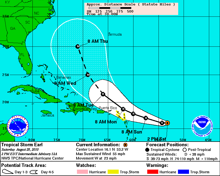
5PM
2PM
5PM
0 likes
-
cycloneye
- Admin
- Posts: 149744
- Age: 69
- Joined: Thu Oct 10, 2002 10:54 am
- Location: San Juan, Puerto Rico
Re: ATL: Tropical Storm EARL - Discussion
For the Caribbean folks,select island where you are to see how close the center of Earl will pass as of the 5 PM advisory. In my case 116 miles from San Juan. 
http://stormcarib.com/closest2.htm
http://stormcarib.com/closest2.htm
0 likes
Visit the Caribbean-Central America Weather Thread where you can find at first post web cams,radars
and observations from Caribbean basin members Click Here
and observations from Caribbean basin members Click Here
Re: ATL: Tropical Storm EARL - Discussion
Agree...
the 36 hour forecast position of 18.3N 61.8W is very close to the extreme n.e. islands:
Results for Barbuda (17.63N, 61.78W):
The eye of the storm is about 46 miles (74 km) away.
Results for Anguilla (18.2N, 63.08W):
The eye of the storm is about 84 miles (136 km) away
Results for St.Maarten/St.Martin (18.05N, 63.12W):
The eye of the storm is about 88 miles (142 km) away.
Migle wrote:I am not really sure why there isn't Hurricane Watches up right now. Maybe they will at 8 or 11
0 likes
Who is online
Users browsing this forum: No registered users and 64 guests