
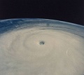
Upto 90kts there, its getting the more classic look now for sure though the eye doesn't look all that well defined right now.
On its way to being a major some point in the next 24hrs I'd have thought!
ATL: Ex-Hurricane DANIELLE - Discussion
Moderator: S2k Moderators
0 likes
Personal Forecast Disclaimer:
The posts in this forum are NOT official forecast and should not be used as such. They are just the opinion of the poster and may or may not be backed by sound meteorological data. They are NOT endorsed by any professional institution or storm2k.org. For official information, please refer to the NHC and NWS products
The posts in this forum are NOT official forecast and should not be used as such. They are just the opinion of the poster and may or may not be backed by sound meteorological data. They are NOT endorsed by any professional institution or storm2k.org. For official information, please refer to the NHC and NWS products


Re: ATL: Hurricane DANIELLE - Discussion
Going to be over its highest OHC water in the next 24 hrs.

0 likes


-
Cryomaniac
- Category 5

- Posts: 1289
- Joined: Tue Aug 15, 2006 2:26 pm
- Location: Newark, Nottinghamshire, UK
- Contact:
Still no closed eyewall though there Hurakan so probably only steady strengthening is likely. The eye looks more defined now though compared to before!
0 likes
Personal Forecast Disclaimer:
The posts in this forum are NOT official forecast and should not be used as such. They are just the opinion of the poster and may or may not be backed by sound meteorological data. They are NOT endorsed by any professional institution or storm2k.org. For official information, please refer to the NHC and NWS products
The posts in this forum are NOT official forecast and should not be used as such. They are just the opinion of the poster and may or may not be backed by sound meteorological data. They are NOT endorsed by any professional institution or storm2k.org. For official information, please refer to the NHC and NWS products

Re:
CrazyC83 wrote:I'd bump it to 95 kt for the advisory. Eye looks clear but the eyewall is not yet closed.
Yeah the eyewall has been a bit ragged ever since that intial influx of dry air, seems to have not really recovered from that despite the current presentation being real neat. Still doesn't look too far away from being a major to me.
0 likes
Personal Forecast Disclaimer:
The posts in this forum are NOT official forecast and should not be used as such. They are just the opinion of the poster and may or may not be backed by sound meteorological data. They are NOT endorsed by any professional institution or storm2k.org. For official information, please refer to the NHC and NWS products
The posts in this forum are NOT official forecast and should not be used as such. They are just the opinion of the poster and may or may not be backed by sound meteorological data. They are NOT endorsed by any professional institution or storm2k.org. For official information, please refer to the NHC and NWS products
-
Cryomaniac
- Category 5
- Posts: 1289
- Joined: Tue Aug 15, 2006 2:26 pm
- Location: Newark, Nottinghamshire, UK
- Contact:
Re: Re:
HURAKAN wrote:Cryomaniac wrote:In before someone says it looks annular...
180º from annular
That was my point. It has a large eye, so someone will say it looks annular.
0 likes
-
neospaceblue
- Tropical Storm

- Posts: 112
- Age: 32
- Joined: Fri Aug 10, 2007 3:17 pm
- Location: Newport News, VA
Re: Re:
Cryomaniac wrote:HURAKAN wrote:Cryomaniac wrote:In before someone says it looks annular...
180º from annular
That was my point. It has a large eye, so someone will say it looks annular.
If they said that, they would be wrong, as a large eye does not define a storm as annular. Characteristics of an annular hurricane from Knaff et al, "Annular hurricanes," Weather and Forecasting, 2003:
When annular hurricanes are compared with the greater population of tropical cyclones, as observed in an infrared (IR) data archive of tropical cyclones, they appear distinctly symmetric about their center. Their appearance in IR imagery is characterized by large circular eye features surrounded by a nearly uniform ring of deep convection and a distinct lack of deep convective features (i.e., spiral bands) outside this ring.
When you compare the examples of annular hurricanes (Luis and Edouard) cited in the paper

to Danielle,

it is easy to see that Danielle does not meet these criteria. In fact, when you look at the SHIPS output, the annular hurricane index is 0 (100 being perfect):
## ANNULAR HURRICANE INDEX (AHI) AL062010 DANIELLE 08/26/10 12 UTC ##
## STORM NOT ANNULAR, SCREENING STEP FAILED, NPASS=5 NFAIL=2 ##
## AHI= 0 (AHI OF 100 IS BEST FIT TO ANN. STRUC., 1 IS MARGINAL, 0 IS NOT ANNULAR) ##
## ANNULAR INDEX RAN NORMALLY
0 likes
Re:
neospaceblue wrote:I would personally estimate 95-100 knots right now based on satellite presentation. I think we might see our first major at 5 PM.
I'd say this is at 95kts right now myself but I wouldn't go to major status just yet simply because I'd like to see the eyewall actually close and convection to be a little bit deeper then it is right now.
0 likes
Personal Forecast Disclaimer:
The posts in this forum are NOT official forecast and should not be used as such. They are just the opinion of the poster and may or may not be backed by sound meteorological data. They are NOT endorsed by any professional institution or storm2k.org. For official information, please refer to the NHC and NWS products
The posts in this forum are NOT official forecast and should not be used as such. They are just the opinion of the poster and may or may not be backed by sound meteorological data. They are NOT endorsed by any professional institution or storm2k.org. For official information, please refer to the NHC and NWS products
-
plasticup
Re: ATL: Hurricane DANIELLE - Discussion
The two recon's scheduled for tomorrow ought to catch this storm near its peak, but I'd like one now to see how that ragged but clear eyewall is doing.
0 likes
Yeah thats the good thing about recon going in tomorrow, we are going to get a good indication as to exactly what the strength of Danielle is...
I do love a good bit of recon to be honest!
I do love a good bit of recon to be honest!
0 likes
Personal Forecast Disclaimer:
The posts in this forum are NOT official forecast and should not be used as such. They are just the opinion of the poster and may or may not be backed by sound meteorological data. They are NOT endorsed by any professional institution or storm2k.org. For official information, please refer to the NHC and NWS products
The posts in this forum are NOT official forecast and should not be used as such. They are just the opinion of the poster and may or may not be backed by sound meteorological data. They are NOT endorsed by any professional institution or storm2k.org. For official information, please refer to the NHC and NWS products
-
plasticup
Re: ATL: Hurricane DANIELLE - Discussion
It's a shame that it takes a threat to land to justify the flights, but I suppose they can't run them daily just for our benefit.
0 likes

-
CrazyC83
- Professional-Met

- Posts: 34316
- Joined: Tue Mar 07, 2006 11:57 pm
- Location: Deep South, for the first time!
Re: ATL: Hurricane DANIELLE - Discussion
plasticup wrote:It's a shame that it takes a threat to land to justify the flights, but I suppose they can't run them daily just for our benefit.
Unless money grew on trees or we funded it ourselves, that is unfortunately correct.
0 likes
Who is online
Users browsing this forum: No registered users and 226 guests