ATL: EX-Tropical Depression FIVE - Discussion
Moderator: S2k Moderators


Re: Models Develop Gulf System - EX-TD5 Thread
The circulation look like its about into the Florida panhandle. Or am I mistaken? Is the convection in the gulf likely to enhance or hinder TD5?
0 likes
-
Stormcenter
- S2K Supporter

- Posts: 6689
- Joined: Wed Sep 03, 2003 11:27 am
- Location: Houston, TX
Re: Models Develop Gulf System - EX-TD5 Thread
Well it looks like some sort of circulation is headed to the FL. panhandle. If this is the case then things may get cooking a lot early
then anyone anticipated. Honestly I don't like what I'm seeing this morning.
then anyone anticipated. Honestly I don't like what I'm seeing this morning.
HeeBGBz wrote:The circulation look like its about into the Florida panhandle. Or am I mistaken? Is the convection in the gulf likely to enhance or hinder TD5?
0 likes
-
Aric Dunn
- Category 5

- Posts: 21238
- Age: 43
- Joined: Sun Sep 19, 2004 9:58 pm
- Location: Ready for the Chase.
- Contact:
Re: Models Develop Gulf System - EX-TD5 Thread
Stormcenter wrote:Well it looks like some sort of circulation is headed to the FL. panhandle. If this is the case then things may get cooking a lot early
then anyone anticipated. Honestly I don't like what I'm seeing this morning.HeeBGBz wrote:The circulation look like its about into the Florida panhandle. Or am I mistaken? Is the convection in the gulf likely to enhance or hinder TD5?
there is a good chance that if the convection off the coast becomes more organized and maintains then any circulation would likely redevelop off the coast since the circulation over land is broad.
0 likes
Note: If I make a post that is brief. Please refer back to previous posts for the analysis or reasoning. I do not re-write/qoute what my initial post said each time.
If there is nothing before... then just ask
Space & Atmospheric Physicist, Embry-Riddle Aeronautical University,
I believe the sky is falling...
If there is nothing before... then just ask
Space & Atmospheric Physicist, Embry-Riddle Aeronautical University,
I believe the sky is falling...
-
PTrackerLA

- Category 5
- Posts: 5281
- Age: 42
- Joined: Thu Oct 10, 2002 8:40 pm
- Location: Lafayette, LA
Re: Models Develop Gulf System - EX-TD5 Thread
Looks like the circulation in south Alabama is quickly dropping south now towards the Florida panhandle and then offshore. It's almost as if the convection firing up in the gulf is pulling it now. This will be very interesting to watch unfold and could be quite a trouble maker rainfall wise if the GFS verifies. Homegrown on the way!
0 likes

Re: Models Develop Gulf System - EX-TD5 Thread
that didnt take long....I wonder how long that convection can maintain today or does it poof tonight....that MLC is moving down pretty quick now and should be off the FL panhandle later tonight.....IMO
0 likes
-
LSU2001
- S2K Supporter
- Posts: 1711
- Age: 58
- Joined: Sat Sep 11, 2004 11:01 pm
- Location: Cut Off, Louisiana
Re: Models Develop Gulf System - EX-TD5 Thread
Yeah, right about the GA.FLA.Alabama corner it appears that there is some type of circulation. may be mid level but what I am seeing is not near columbus Ga. like some posters are pointing out. The center of the overall low may be further north but there is some definite spin almost to the panhandle.
tim
0 likes
Personal Forecast Disclaimer:
The posts in this forum are NOT official forecast and should not be used as such. They are NOT endorsed by any professional institution or storm2k.org. For official information, please refer to the NHC and NWS products.
The posts in this forum are NOT official forecast and should not be used as such. They are NOT endorsed by any professional institution or storm2k.org. For official information, please refer to the NHC and NWS products.
-
Portastorm

- Storm2k Moderator

- Posts: 9955
- Age: 63
- Joined: Fri Jul 11, 2003 9:16 am
- Location: Round Rock, TX
- Contact:
Re: Models Develop Gulf System - EX-TD5 Thread
Well, if the GFS verifies, you folks in SE Louisiana should feel free to send the rain about 500 miles to the west. SSTs are at all-time high levels in the pools of ROCK and srainhoutx as well as in my little fish pond in the backyard. 
0 likes
-
cycloneye

- Admin

- Posts: 149719
- Age: 69
- Joined: Thu Oct 10, 2002 10:54 am
- Location: San Juan, Puerto Rico
Re: Models Develop Gulf System - EX-TD5 Thread
Hey peeps, recon will be flying tommorow afternoon.
WEATHER RECONNAISSANCE FLIGHTS
CARCAH, NATIONAL HURRICANE CENTER, MIAMI, FL.
1130 AM EDT SUN 15 AUGUST 2010
SUBJECT: TROPICAL CYCLONE PLAN OF THE DAY (TCPOD)
VALID 16/1100Z TO 17/1100Z AUGUST 2010
TCPOD NUMBER.....10-076
I. ATLANTIC REQUIREMENTS
1. SUSPECT AREA GULF OF MEXICO - REMNENTS OF TD 05
FLIGHT ONE -- TEAL 70
A. 16/1800Z
B. AFXXX 0405A INVEST
C. 16/1700Z
D. 29.5N 86.0W
E. 16/1700-2200Z
F. SFC TO 10,000 FT
FLIGHT TWO -- TEAL 71
A. 17/0600Z- 1200Z
B. AFXXX 0505A CYCLONE
C. 17/0500Z
D. 29.5N 87.5W
E. 17/0500-1200Z
F. SFC TO 15,000 FT
2. OUTLOOK FOR SUCCEEDING DAY: CONTINUE 6 HRLY FIXES
IF SYSTEM DEVELOPS.
0 likes
Visit the Caribbean-Central America Weather Thread where you can find at first post web cams,radars
and observations from Caribbean basin members Click Here
and observations from Caribbean basin members Click Here
-
Pearl River

- S2K Supporter
- Posts: 825
- Age: 67
- Joined: Fri Dec 09, 2005 6:07 pm
- Location: SELa
Re: Models Develop Gulf System - EX-TD5 Thread
We've had enough here in Pearl River to last a couple of weeks. I can throw a line out my back door and haul in a few fish. The problem is, I'm about 3 miles from the river.
Last edited by Pearl River on Sun Aug 15, 2010 10:36 am, edited 1 time in total.
0 likes

Re: Models Develop Gulf System - EX-TD5 Thread
From looking at the satellite and radar loop the circulation looks to be over the FLA Panhandle however WXman57 surface obs show the low pressure center much further N. It will be interesting to see if the low center attempts to form more S later today.
0 likes
The following post is NOT an official forecast and should not be used as such. It is just the opinion of the poster and may or may not be backed by sound meteorological data. It is NOT endorsed by any professional institution including storm2k.org For Official Information please refer to the NHC and NWS products.
-
F-dubWxGuy
- Tropical Wave

- Posts: 5
- Age: 32
- Joined: Wed Jun 23, 2010 7:22 pm
- Location: Shalimar, FL (Okaloosa County)
Re: Models Develop Gulf System - EX-TD5 Thread
curtadams wrote:Looks like what would be a feeder band if this were out in the water. Since the center is on land it's producing most of the convection. I suppose a relocation is possible, but the models are predicting very heavy rain offshore without a relocation.LSU2001 wrote:What is that big burst of convection south east of La. off the Mississippi gulf coast? It that related to ex-td5 or is this burst simply daily thunderstorms? Also could we see the center relocate to an offshore position near the convection?
According to the NWS Mobile/Pensacola, the large area of convection is development ahead of a shortwave trough.
AREA FORECAST DISCUSSION
NATIONAL WEATHER SERVICE MOBILE AL
451 AM CDT SUN AUG 15 2010
.SHORT TERM...EARLY THIS MORNING WE NOTE A UPPER
LEVEL HIGH PARKED OVER LOUISIANA AND WESTERN MISSISSIPPI WITH A
SOUTHBOUND SHORTWAVE CARVING OUT A TROUGH ON THE EAST SIDE OF THIS
RIDGE OVER EASTERN MISSISSIPPI AND ALABAMA. SCATTERED THUNDERSTORMS
HAVE DEVELOPED INLAND AHEAD OF THE SHORTWAVE TROUGH MOVING SOUTHEAST
TOWARDS THE COAST...AND WE EXPECT TO SEE NUMEROUS THUNDERSTORMS
ACROSS THE FORECAST AREA TODAY AS THIS FORCING MECHANISM SLOWLY
MIGRATES SOUTHWARD ACROSS THE REGION. STORMS WILL MOVE GENERALLY
NORTHWEST TO SOUTHEAST TODAY...WITH SOME MOVING SLOW ENOUGH TO
PRODUCE LOCALIZED FLOODING OF POOR DRAINAGE AREAS.
0 likes
Hottest Temp (YTD): 100° (7/31)
Coldest Temp (YTD): 17° (1/11)
Coldest Temp (YTD): 17° (1/11)

-
Portastorm
- Storm2k Moderator
- Posts: 9955
- Age: 63
- Joined: Fri Jul 11, 2003 9:16 am
- Location: Round Rock, TX
- Contact:
Re: Models Develop Gulf System - EX-TD5 Thread
redfish1 wrote:is it expected to track towards SETX?
GFS says no, Euro says yes.
0 likes
-
srainhoutx

- S2K Supporter
- Posts: 6919
- Age: 68
- Joined: Sun Jan 14, 2007 11:34 am
- Location: Haywood County, NC
- Contact:
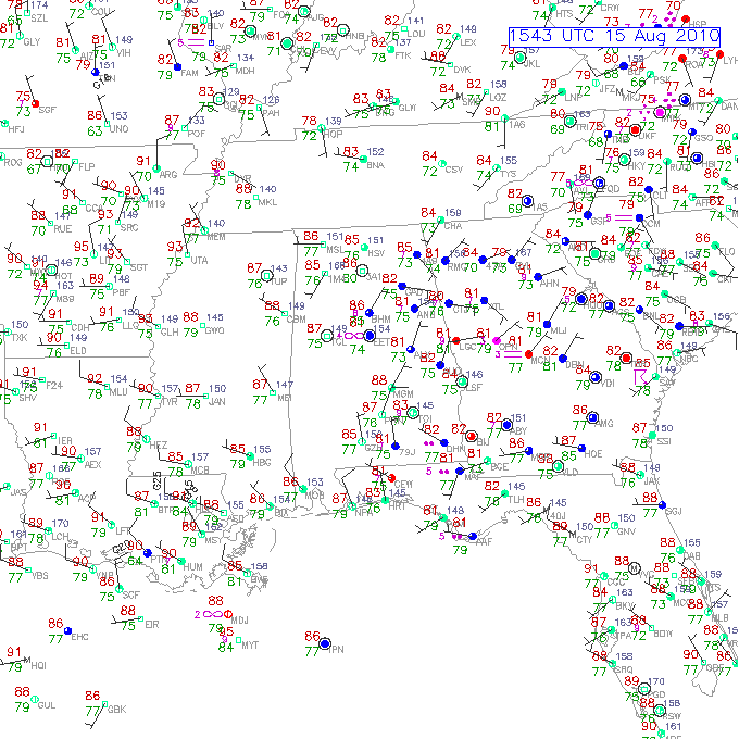
Re: Models Develop Gulf System - EX-TD5 Thread
Latest surface obs...
0 likes
Carla/Alicia/Jerry(In The Eye)/Michelle/Charley/Ivan/Dennis/Katrina/Rita/Wilma/Ike/Harvey
Member: National Weather Association
Wx Infinity Forums
http://wxinfinity.com/index.php
Facebook.com/WeatherInfinity
Twitter @WeatherInfinity
Member: National Weather Association
Wx Infinity Forums
http://wxinfinity.com/index.php
Facebook.com/WeatherInfinity
Twitter @WeatherInfinity
-
MiamiHurricanes10

- S2K Supporter
- Posts: 260
- Joined: Mon Jul 19, 2010 7:56 pm
- Location: Miami, Florida
Re: Models Develop Gulf System - EX-TD5 Thread
cycloneye wrote:Hey peeps, recon will be flying tommorow afternoon.
WEATHER RECONNAISSANCE FLIGHTS
CARCAH, NATIONAL HURRICANE CENTER, MIAMI, FL.
1130 AM EDT SUN 15 AUGUST 2010
SUBJECT: TROPICAL CYCLONE PLAN OF THE DAY (TCPOD)
VALID 16/1100Z TO 17/1100Z AUGUST 2010
TCPOD NUMBER.....10-076
I. ATLANTIC REQUIREMENTS
1. SUSPECT AREA GULF OF MEXICO - REMNENTS OF TD 05
FLIGHT ONE -- TEAL 70
A. 16/1800Z
B. AFXXX 0405A INVEST
C. 16/1700Z
D. 29.5N 86.0W
E. 16/1700-2200Z
F. SFC TO 10,000 FT
FLIGHT TWO -- TEAL 71
A. 17/0600Z- 1200Z
B. AFXXX 0505A CYCLONE
C. 17/0500Z
D. 29.5N 87.5W
E. 17/0500-1200Z
F. SFC TO 15,000 FT
2. OUTLOOK FOR SUCCEEDING DAY: CONTINUE 6 HRLY FIXES
IF SYSTEM DEVELOPS.
Fly? If it's on the Alabama coast, would they need to leave the runway in order to measure the pressure/wind?
0 likes
-
Stormcenter
- S2K Supporter
- Posts: 6689
- Joined: Wed Sep 03, 2003 11:27 am
- Location: Houston, TX
Re:
I think that's pretty obvious even on this IR loop. IMO
http://www.rap.ucar.edu/weather/satelli ... uration=12
http://www.rap.ucar.edu/weather/satelli ... uration=12
MiamiHurricanes10 wrote:GHCC satellite images suggest that whatever is left of the low/mid level circulation of ex-05L is currently placed over southeastern Alabama and moving slowly southeastward. Should emerge fully by tonight.
0 likes
Re: Models Develop Gulf System - EX-TD5 Thread
I wonder how far that shortwave trough will push the front?
The feature has obvious formation to it so once it hits water it should have an easy time redeveloping. That would be something if we got a second wave of rain from the same system.
The feature has obvious formation to it so once it hits water it should have an easy time redeveloping. That would be something if we got a second wave of rain from the same system.
0 likes
-
KFDM Meteorologist

- Professional-Met

- Posts: 1314
- Joined: Tue May 16, 2006 9:52 pm
- Location: Upper Texas Coast/Orange County
-
Dean4Storms
- S2K Supporter
- Posts: 6358
- Age: 63
- Joined: Sun Aug 31, 2003 1:01 pm
- Location: Miramar Bch. FL
Who is online
Users browsing this forum: No registered users and 40 guests