ATL: EX-Tropical Depression FIVE - Discussion
Moderator: S2k Moderators


Re: Models Develop Gulf System - EX-TD5 Thread
Does this have to get back over water before it can be an invest again?
0 likes
-
cycloneye

- Admin

- Posts: 149719
- Age: 69
- Joined: Thu Oct 10, 2002 10:54 am
- Location: San Juan, Puerto Rico
Re:
StormingB81 wrote:Ok question....has a storm system ever gone onto land. stop back strack back into the ocean and became a storm or will this be a first IF it does at all happen?
Ivan in 2004.

0 likes
Visit the Caribbean-Central America Weather Thread where you can find at first post web cams,radars
and observations from Caribbean basin members Click Here
and observations from Caribbean basin members Click Here
-
wxman57

- Moderator-Pro Met

- Posts: 23175
- Age: 68
- Joined: Sat Jun 21, 2003 8:06 pm
- Location: Houston, TX (southwest)
Re: Models Develop Gulf System - EX-TD5 Thread
Surface obs indicate the very weak low center (1013mb and 5-10 kt wind) is located over western Georgia, about 200 miles from the Gulf northeast of Columbus. You can keep track of it with surface obs here:
http://www.rap.ucar.edu/weather/surface/
Most likely, it'll move south near the coast and drift westward on Monday/Tuesday, enhancing rain across southern AL/MS/LA before turning back northward. Might be able to reach SE TX before it turns back north and gets picked up by the approaching trof/front. Development chances appear to be low, mostly because it probably won't be offshore enough.
0 likes
-
StormingB81

- S2K Supporter

- Posts: 5676
- Age: 44
- Joined: Thu Aug 27, 2009 1:45 am
- Location: Rockledge, Florida
Re: Re:
cycloneye wrote:StormingB81 wrote:Ok question....has a storm system ever gone onto land. stop back strack back into the ocean and became a storm or will this be a first IF it does at all happen?
Ivan in 2004.
http://weather.unisys.com/hurricane/atl ... /track.gif
Thank you! I thought it was odd if it where to go inland then back over waters then back onto land..yes I know it has happend before like if it where to go through florida then into the gulf..I am talking about like this one headed into the coast and backing up..thanks again for the answer
Edited to remove [IMG] tags.. wxman57
0 likes
-
CYCLONE MIKE
- Category 5

- Posts: 2183
- Joined: Tue Aug 31, 2004 6:04 pm
- Location: Gonzales, LA
Re: Models Develop Gulf System - EX-TD5 Thread
[quote="Frank P"]Interesting how the northern GOM convection has been on the increase all morning...[/quote
Frank,
What I find really interesting about that is last night on our local weather the ocm ran their in house model(Titan model?) that showed the convection developing first thing this morning. More importantly also showed a low developing in the gulf south of Tallahassee and really spinning up as it moved slowly across the northern gulf. Said it depicted a strong tropical storm that had a good 24 hrs over water to get cranking. Just something to watch for.
0 likes
-
cycloneye
- Admin
- Posts: 149719
- Age: 69
- Joined: Thu Oct 10, 2002 10:54 am
- Location: San Juan, Puerto Rico
Re: Models Develop Gulf System - EX-TD5 Thread
12z Best Track
AL, 05, 2010081512, , BEST, 0, 318N, 849W, 20, 1013, LO
ftp://ftp.tpc.ncep.noaa.gov/atcf/tcweb/ ... 010.invest
AL, 05, 2010081512, , BEST, 0, 318N, 849W, 20, 1013, LO
ftp://ftp.tpc.ncep.noaa.gov/atcf/tcweb/ ... 010.invest
0 likes
Visit the Caribbean-Central America Weather Thread where you can find at first post web cams,radars
and observations from Caribbean basin members Click Here
and observations from Caribbean basin members Click Here
Look what models are running again!
6z GFDL:
http://moe.met.fsu.edu/cgi-bin/gfdltc2. ... =Animation
6z HWRF:
http://moe.met.fsu.edu/cgi-bin/hwrftc2. ... =Animation

6z GFDL:
http://moe.met.fsu.edu/cgi-bin/gfdltc2. ... =Animation
6z HWRF:
http://moe.met.fsu.edu/cgi-bin/hwrftc2. ... =Animation
0 likes
Re: Models Develop Gulf System - EX-TD5 Thread
Updated New Orleans AfD around 530 says low around Montgomery, slightly north of where models indicate. They expect 20% chances to rise due to very favorable environment (minus body of water). Don't seem to favor GFS or Euro solution. Concern is heavy rain with the saturated grounds we already have.
0 likes
-
lostsole
- Tropical Depression

- Posts: 55
- Age: 56
- Joined: Thu Aug 13, 2009 3:31 pm
- Location: Pensacola, FL
- Contact:
Re: Models Develop Gulf System - EX-TD5 Thread
Do those models have it looping again at the end back to the Gulf?
0 likes
-
srainhoutx

- S2K Supporter
- Posts: 6919
- Age: 68
- Joined: Sun Jan 14, 2007 11:34 am
- Location: Haywood County, NC
- Contact:
Re: Models Develop Gulf System - EX-TD5 Thread
Correct me if I'm wrong, but it looks like the models are too far S with this disturbance already.
0 likes
Carla/Alicia/Jerry(In The Eye)/Michelle/Charley/Ivan/Dennis/Katrina/Rita/Wilma/Ike/Harvey
Member: National Weather Association
Wx Infinity Forums
http://wxinfinity.com/index.php
Facebook.com/WeatherInfinity
Twitter @WeatherInfinity
Member: National Weather Association
Wx Infinity Forums
http://wxinfinity.com/index.php
Facebook.com/WeatherInfinity
Twitter @WeatherInfinity

Re: Models Develop Gulf System - EX-TD5 Thread
Is there any chance that the High pressure over the TX coast will move and allow some of that rain to come here? My ground is cracked!
0 likes
Alicia, Rita, Ike, Harvey and Beryl...moved to Splendora lol
-
dixiebreeze
- S2K Supporter
- Posts: 5140
- Joined: Wed Sep 03, 2003 5:07 pm
- Location: crystal river, fla.
-
wxman57
- Moderator-Pro Met
- Posts: 23175
- Age: 68
- Joined: Sat Jun 21, 2003 8:06 pm
- Location: Houston, TX (southwest)
Re: Models Develop Gulf System - EX-TD5 Thread
srainhoutx wrote:Correct me if I'm wrong, but it looks like the models are too far S with this disturbance already.
Obs showed the weak low NE of Columbus, GA at 12Z, well north of where the models initialized.
0 likes
-
wxman57
- Moderator-Pro Met
- Posts: 23175
- Age: 68
- Joined: Sat Jun 21, 2003 8:06 pm
- Location: Houston, TX (southwest)
Re: Models Develop Gulf System - EX-TD5 Thread
dixiebreeze wrote:This isn't ex-TD5 anymore, it's TD5 per NHC
No, it's not. They haven't reclassified it over Georgia. No advisories are being written.
0 likes
-
dixiebreeze
- S2K Supporter
- Posts: 5140
- Joined: Wed Sep 03, 2003 5:07 pm
- Location: crystal river, fla.
Re: Models Develop Gulf System - EX-TD5 Thread
Sorry, going by the new IR Floater designation: http://www.ssd.noaa.gov/PS/TROP/float1.html
0 likes
-
srainhoutx
- S2K Supporter
- Posts: 6919
- Age: 68
- Joined: Sun Jan 14, 2007 11:34 am
- Location: Haywood County, NC
- Contact:
Re: Models Develop Gulf System - EX-TD5 Thread
Thanks wxman57. Just making sure I'm awake. Latest from the main Navy page...
0 likes
Carla/Alicia/Jerry(In The Eye)/Michelle/Charley/Ivan/Dennis/Katrina/Rita/Wilma/Ike/Harvey
Member: National Weather Association
Wx Infinity Forums
http://wxinfinity.com/index.php
Facebook.com/WeatherInfinity
Twitter @WeatherInfinity
Member: National Weather Association
Wx Infinity Forums
http://wxinfinity.com/index.php
Facebook.com/WeatherInfinity
Twitter @WeatherInfinity
-
cycloneye
- Admin
- Posts: 149719
- Age: 69
- Joined: Thu Oct 10, 2002 10:54 am
- Location: San Juan, Puerto Rico
Re: Models Develop Gulf System - EX-TD5 Thread
Until advisories are written again if they do so, is then official and this thread goes back to Active Storms/invests Forum.
0 likes
Visit the Caribbean-Central America Weather Thread where you can find at first post web cams,radars
and observations from Caribbean basin members Click Here
and observations from Caribbean basin members Click Here

Re: Models Develop Gulf System - EX-TD5 Thread
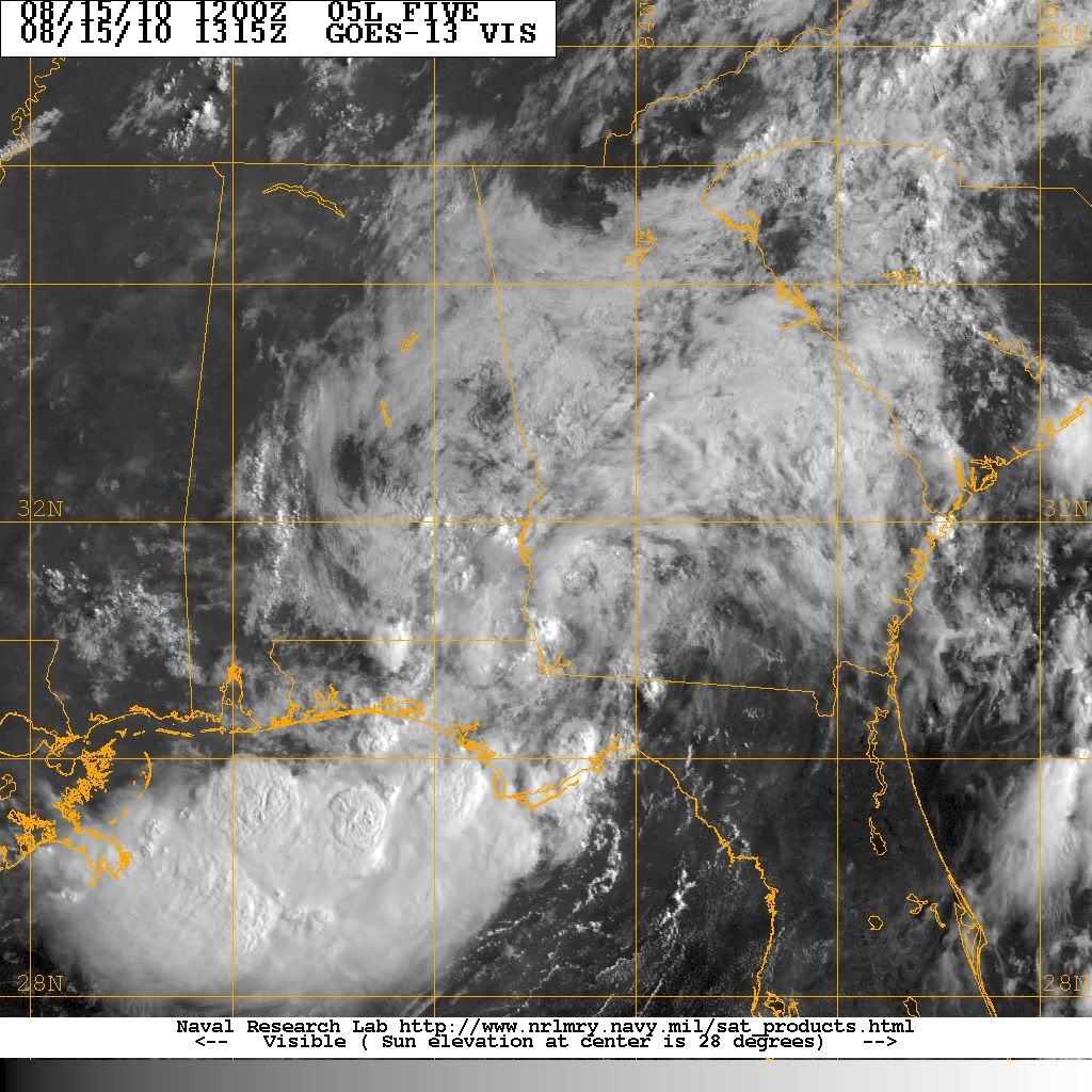
Broad cyclonic turning is evident over the SE Alabama near the tri-state location - this is well south of the reported surface low. I believe this is the area to watch for development as it slowly slides off to the S or S-SE.
http://weather.cod.edu/analysis/loops/satmaster.pl?Alabama
http://weather.cod.edu/analysis/loops/satmaster.pl?Alabama
0 likes
-
srainhoutx
- S2K Supporter
- Posts: 6919
- Age: 68
- Joined: Sun Jan 14, 2007 11:34 am
- Location: Haywood County, NC
- Contact:
Re: Models Develop Gulf System - EX-TD5 Thread
HPC: Update...
MEANWHILE...CONFIDENCE REMAINS LOW WITH OUR DEPICTION OF THE
REMAINS OF TD FIVE FORECAST NEAR THE GULF COAST DURING THE SHORT
RANGE BEFORE WEAKENING OVER THE LOWER MS VALLEY DURING THE FIRST
HALF OF THE MEDIUM RANGE. THIS SYSTEM HAS POTENTIAL TO FOCUS SOME
HEAVY DOWNPOURS LOCALLY...BUT OUR COMPROMISE GUIDANCE TRACK
REMAINS AT ODDS WITH THE 00 UTC GFS THAT BRINGS THE SYSTEM MUCH
FARTHER NEWD AND THE 00 UTC ECMWF/06 UTC DGEX ARE MUCH FARTHER
SWWD INTO TX.
0 likes
Carla/Alicia/Jerry(In The Eye)/Michelle/Charley/Ivan/Dennis/Katrina/Rita/Wilma/Ike/Harvey
Member: National Weather Association
Wx Infinity Forums
http://wxinfinity.com/index.php
Facebook.com/WeatherInfinity
Twitter @WeatherInfinity
Member: National Weather Association
Wx Infinity Forums
http://wxinfinity.com/index.php
Facebook.com/WeatherInfinity
Twitter @WeatherInfinity
Who is online
Users browsing this forum: No registered users and 46 guests