ATL: EX-Tropical Depression FIVE - Discussion

Moderator: S2k Moderators

Message
Author
User avatar
southerngale
Retired Staff
Retired Staff
Posts: 27418
Joined: Thu Oct 10, 2002 1:27 am
Location: Southeast Texas (Beaumont area)

Re: Models Develop Gulf System - EX-TD5 Thread

#1601 Postby southerngale » Sat Aug 14, 2010 5:32 pm

hurrican19 wrote:Send it to Central TX.. We need some rain again, bad! Would love to turn my sprinkler system off!

Your profile says Orange County.... you moved?

Edit: Nevermind... I think I remember now.
0 likes   
Please support Storm2k by making a donation today. It is greatly appreciated! Click here: Image

Image my Cowboys Image my RocketsImage my Astros

Wx_Warrior
Category 5
Category 5
Posts: 2718
Joined: Thu Aug 03, 2006 3:58 pm
Location: Beaumont, TX

Re: Models Develop Gulf System - EX-TD5 Thread

#1602 Postby Wx_Warrior » Sat Aug 14, 2010 5:35 pm

That's my brother! (KFDM_MET) LOL

Glad its bone dry here....or we would really need scuba gear.
0 likes   

User avatar
KFDM Meteorologist
Professional-Met
Professional-Met
Posts: 1314
Joined: Tue May 16, 2006 9:52 pm
Location: Upper Texas Coast/Orange County

#1603 Postby KFDM Meteorologist » Sat Aug 14, 2010 5:45 pm

We'll see some rain and certainly areas east of SE TX (on the wet side of the system) in LA will see even more if this pans out. I want to see how far west this actually makes it.
0 likes   

Dean4Storms
S2K Supporter
S2K Supporter
Posts: 6358
Age: 62
Joined: Sun Aug 31, 2003 1:01 pm
Location: Miramar Bch. FL

#1604 Postby Dean4Storms » Sat Aug 14, 2010 5:58 pm

Looks to me on radar that our MLC is dropping southward hugging the east central AL/ GA Border line!!
0 likes   

Stormcenter
S2K Supporter
S2K Supporter
Posts: 6684
Joined: Wed Sep 03, 2003 11:27 am
Location: Houston, TX

Re:

#1605 Postby Stormcenter » Sat Aug 14, 2010 5:59 pm

Can you post the link?

Thanks!


Dean4Storms wrote:Looks to me on radar that our MLC is dropping southward hugging the east central AL/ GA Border line!!
0 likes   

User avatar
Pearl River
S2K Supporter
S2K Supporter
Posts: 825
Age: 66
Joined: Fri Dec 09, 2005 6:07 pm
Location: SELa

Re: Models Develop Gulf System - EX-TD5 Thread

#1606 Postby Pearl River » Sat Aug 14, 2010 6:03 pm

0 likes   

User avatar
Ivanhater
Storm2k Moderator
Storm2k Moderator
Posts: 11161
Age: 38
Joined: Fri Jul 01, 2005 8:25 am
Location: Pensacola

Re: Models Develop Gulf System - EX-TD5 Thread

#1607 Postby Ivanhater » Sat Aug 14, 2010 6:06 pm

Should drop down to Apalachicola and ride the coast along the Florida Panhandle westward. I suspect a lot of Flood watches to be posted soon all across the northern Gulf.
0 likes   
Michael

User avatar
srainhoutx
S2K Supporter
S2K Supporter
Posts: 6919
Age: 67
Joined: Sun Jan 14, 2007 11:34 am
Location: Haywood County, NC
Contact:

Re: Models Develop Gulf System - EX-TD5 Thread

#1608 Postby srainhoutx » Sat Aug 14, 2010 6:11 pm

Sunset...

Image
0 likes   
Carla/Alicia/Jerry(In The Eye)/Michelle/Charley/Ivan/Dennis/Katrina/Rita/Wilma/Ike/Harvey

Member: National Weather Association
Wx Infinity Forums
http://wxinfinity.com/index.php

Facebook.com/WeatherInfinity
Twitter @WeatherInfinity

User avatar
Ivanhater
Storm2k Moderator
Storm2k Moderator
Posts: 11161
Age: 38
Joined: Fri Jul 01, 2005 8:25 am
Location: Pensacola

Re: Models Develop Gulf System - EX-TD5 Thread

#1609 Postby Ivanhater » Sat Aug 14, 2010 6:19 pm

Nogaps starts winding it up South of Pensacola

Image

Image

18z Canadan has some intense rainfall

Image

Image

Image
0 likes   
Michael

User avatar
micktooth
S2K Supporter
S2K Supporter
Posts: 391
Joined: Mon Jul 11, 2005 3:47 pm
Location: PreK:New Orleans,PostK:Colorado

Re: Models Develop Gulf System - EX-TD5 Thread

#1610 Postby micktooth » Sat Aug 14, 2010 6:37 pm

Any word on possible rainfall totals in the New Orleans area? Brings back nasty memories of my old house flooding from training thunderstorms in 1995 and Allison in 2001.
0 likes   

StormClouds63
Category 2
Category 2
Posts: 583
Age: 62
Joined: Tue May 13, 2008 11:56 am
Location: Southwest Louisiana

#1611 Postby StormClouds63 » Sat Aug 14, 2010 6:58 pm

Lake Charles NWS:

INTERESTING FEATURE HEADING OUR WAY BY EARLY TO MID OF NEXT WEEK. AN AREA OF LOW PRESSURE OVER ALABAMA WHICH IS THE REMNANTS OF T.D.
5 APPEARS THAT IT WILL MOVE BACK TOWARDS THE SOUTHWEST INTO THE NORTH GULF COAST REGION THE NEXT COUPLE OF DAYS. ALL MODELS SUGGEST
THIS LOW PRESSURE WILL TRACK ACROSS SOUTHERN LOUISIANA TUESDAY AND
WEDNESDAY BEFORE MOVING BACK NORTHWARD. THE GFS IS A LITTLE FASTER AND MORE AGGRESSIVE WITH THIS LOW THAN THE ECMWF AND NAM. THIS SLOW MOVING FEATURE COULD HAVE THE POTENTIAL TO PRODUCE HEAVY
RAINFALL OVER THE AREA ESPECIALLY THE EASTERN AND SOUTHERN CWA. HPC FOUR TO FIVE QPF OUTLOOK SUGGEST TOTALS EXCEEDING 5 INCHES IN SOME AREAS. NEEDLESS TO SAY THIS IS A FEATURE COULD BRING THE AREA A HEAVY RAINFALL AND FLOODING THREAT. STAY TUNED.
0 likes   

User avatar
Steve
S2K Supporter
S2K Supporter
Posts: 9621
Joined: Sat Apr 05, 2003 11:41 pm
Location: Not a state-caster

#1612 Postby Steve » Sat Aug 14, 2010 6:59 pm

On the larger, regional radar, it looks like the southward descent still has an eastward component (SSE?). You can see that the front north of there is pressuring the system back down south.

http://radar.weather.gov/Conus/southmissvly_loop.php
0 likes   

User avatar
MississippiWx
S2K Supporter
S2K Supporter
Posts: 1699
Joined: Sat Aug 14, 2010 1:44 pm
Location: Hattiesburg, Mississippi

Re:

#1613 Postby MississippiWx » Sat Aug 14, 2010 7:16 pm

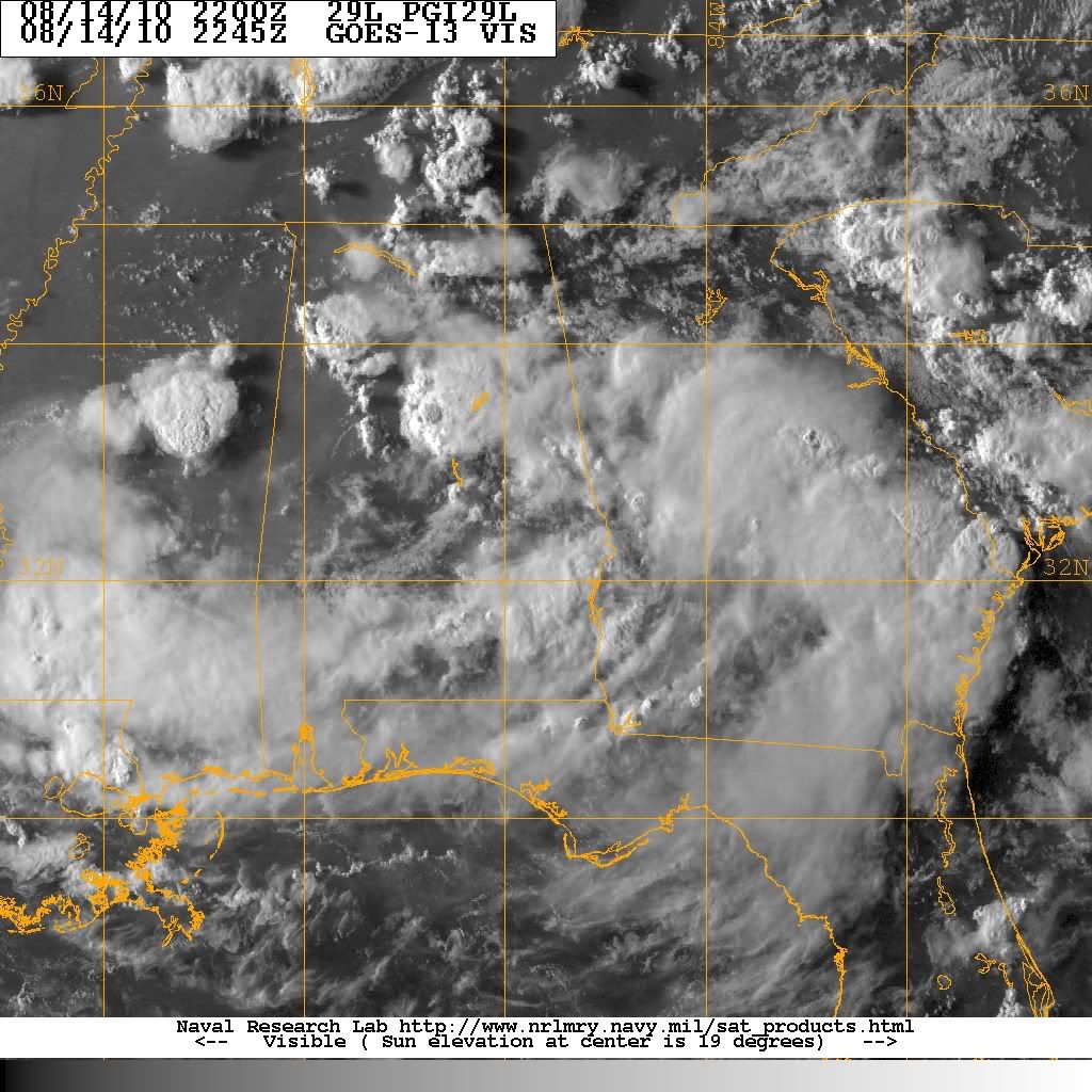
Steve wrote:On the larger, regional radar, it looks like the southward descent still has an eastward component (SSE?). You can see that the front north of there is pressuring the system back down south.

http://radar.weather.gov/Conus/southmissvly_loop.php


Yeah, it should move SSE for several hours before commencing a more true southward motion. How long it stays on that southward motion in the key. The circulation is maintaining itself very well over land and it actually looks tropical at the moment. That will only help its chances once/if it emerges over water.
0 likes   
This post is not an official forecast and should not be used as such. It is just the opinion of MississippiWx and may or may not be backed by sound meteorological data. It is not endorsed by any professional institution including storm2k.org. For Official Information please refer to the NHC and NWS products.

User avatar
Steve
S2K Supporter
S2K Supporter
Posts: 9621
Joined: Sat Apr 05, 2003 11:41 pm
Location: Not a state-caster

#1614 Postby Steve » Sat Aug 14, 2010 7:20 pm

>>Yeah, it should move SSE for several hours before commencing a more true southward motion. How long it stays on that southward motion in the key. The circulation is maintaining itself very well over land and it actually looks tropical at the moment. That will only help its chances once/if it emerges over water.

Yeah, I'm certainly interested in how far east it gets throwing in the assumption that potentially the more time over water, the more chance of regeneration into something material.
0 likes   

User avatar
MississippiWx
S2K Supporter
S2K Supporter
Posts: 1699
Joined: Sat Aug 14, 2010 1:44 pm
Location: Hattiesburg, Mississippi

#1615 Postby MississippiWx » Sat Aug 14, 2010 7:39 pm

Just studied the steering currents that are forecast out to 72 hours. By the looks of things, ex-TD5 should begin emerging out over the Gulf by 00z Monday (this time tomorrow) and should be south of Pensacola by Monday evening. By Tuesday afternoon, steering currents should become weaker and slow the pace of the system. Late Tuesday night into early Wednesday, the system should be making landfall around the mouth of the Mississippi River in Louisiana. Looking at the shear forecast, upper level conditions should be favorable to very favorable for tropical development. Going by the current steering forecast, I have to believe it will emerge over water. Just how far it emerges over water will determine the strength. If the center is able to move 50 miles or more off the coast, I like the chances of it becoming a minimal to moderate strength tropical storm. All of this is subject to change if the steering currents change between now and then.
0 likes   
This post is not an official forecast and should not be used as such. It is just the opinion of MississippiWx and may or may not be backed by sound meteorological data. It is not endorsed by any professional institution including storm2k.org. For Official Information please refer to the NHC and NWS products.

Dean4Storms
S2K Supporter
S2K Supporter
Posts: 6358
Age: 62
Joined: Sun Aug 31, 2003 1:01 pm
Location: Miramar Bch. FL

#1616 Postby Dean4Storms » Sat Aug 14, 2010 7:42 pm

Well looking at the current situation compared to what each model was portraying it looks like the EURO and CMC could be correct it bringing it down near Appalachicola. If that occurs it will have more time over water. The GFS has it moving more SW toward P'Cola, don't see that happening at all.
0 likes   

User avatar
MississippiWx
S2K Supporter
S2K Supporter
Posts: 1699
Joined: Sat Aug 14, 2010 1:44 pm
Location: Hattiesburg, Mississippi

Re:

#1617 Postby MississippiWx » Sat Aug 14, 2010 7:46 pm

Dean4Storms wrote:Well looking at the current situation compared to what each model was portraying it looks like the EURO and CMC could be correct it bringing it down near Appalachicola. If that occurs it will have more time over water. The GFS has it moving more SW toward P'Cola, don't see that happening at all.


Yeah, the steering currents I used were from the GFS. So if the steering currents from the GFS are incorrect, then so am I! LOL. If it emerges closer to the Big Bend, then we are going to have a bigger problem on our hands...
0 likes   
This post is not an official forecast and should not be used as such. It is just the opinion of MississippiWx and may or may not be backed by sound meteorological data. It is not endorsed by any professional institution including storm2k.org. For Official Information please refer to the NHC and NWS products.

User avatar
KWT
Category 5
Category 5
Posts: 31415
Joined: Tue Aug 17, 2004 11:02 am
Location: UK!!!

Re:

#1618 Postby KWT » Sat Aug 14, 2010 7:47 pm

Dean4Storms wrote:Well looking at the current situation compared to what each model was portraying it looks like the EURO and CMC could be correct it bringing it down near Appalachicola. If that occurs it will have more time over water. The GFS has it moving more SW toward P'Cola, don't see that happening at all.


If it does get over water like those models are suggesting, then no reason why this one doesn't have a shot at redeveloping, its as simple as that really, conditions look good for possibly redevelopment.
0 likes   
Personal Forecast Disclaimer:
The posts in this forum are NOT official forecast and should not be used as such. They are just the opinion of the poster and may or may not be backed by sound meteorological data. They are NOT endorsed by any professional institution or storm2k.org. For official information, please refer to the NHC and NWS products

User avatar
Steve
S2K Supporter
S2K Supporter
Posts: 9621
Joined: Sat Apr 05, 2003 11:41 pm
Location: Not a state-caster

#1619 Postby Steve » Sat Aug 14, 2010 7:53 pm

Dean,

Was that the 18z or the general consensus of today's runs?

>>Just how far it emerges over water will determine the strength. If the center is able to move 50 miles or more off the coast, I like the chances of it becoming a minimal to moderate strength tropical storm. All of this is subject to change if the steering currents change between now and then.

I'd have to agree with you. What I'm not sure of anymore is weaker systems close to land because it seems that earlier in the season the heat coming off the land helps circulation either with landfalling or paralleling systems. I've got some ideas, but I just don't understand the phenomena well enough right now. But more and more we've been seeing some tightening probably either due to frictional effects or heat exchange. But this should give us some opportunity to watch the evolution of a coast hugging storm and to see if there's anything unexpected with tightening or loosening of the center and how and when it reaches its strongest pulse. Will be an interesting 3-4 days while we wait for the meat of the season.
Last edited by Steve on Sat Aug 14, 2010 7:54 pm, edited 1 time in total.
0 likes   

User avatar
cycloneye
Admin
Admin
Posts: 145330
Age: 68
Joined: Thu Oct 10, 2002 10:54 am
Location: San Juan, Puerto Rico

Re: Models Develop Gulf System - EX-TD5 Thread

#1620 Postby cycloneye » Sat Aug 14, 2010 7:53 pm

Here are the last two positions by Best Track. Is not climbing in latitude anymore.

AL, 05, 2010081418, , BEST, 0, 330N, 855W, 20, 1013, LO, 0, , 0, 0, 0, 0,
AL, 05, 2010081500, , BEST, 0, 329N, 854W, 20, 1012, LO

ftp://ftp.tpc.ncep.noaa.gov/atcf/tcweb/ ... 010.invest
0 likes   
Visit the Caribbean-Central America Weather Thread where you can find at first post web cams,radars
and observations from Caribbean basin members Click Here


Return to “2010”

Who is online

Users browsing this forum: No registered users and 5 guests