ATL: EX-Tropical Depression FIVE - Discussion

Moderator: S2k Moderators

Message
Author
User avatar
srainhoutx
S2K Supporter
S2K Supporter
Posts: 6919
Age: 67
Joined: Sun Jan 14, 2007 11:34 am
Location: Haywood County, NC
Contact:

Re: ATL: INVEST 94L - Discussion

#481 Postby srainhoutx » Tue Aug 10, 2010 11:56 am

cperez1594 wrote:BP has suspended all operations in the GOM now back to 94L :)


Link please.
0 likes   
Carla/Alicia/Jerry(In The Eye)/Michelle/Charley/Ivan/Dennis/Katrina/Rita/Wilma/Ike/Harvey

Member: National Weather Association
Wx Infinity Forums
http://wxinfinity.com/index.php

Facebook.com/WeatherInfinity
Twitter @WeatherInfinity

User avatar
MGC
S2K Supporter
S2K Supporter
Posts: 5899
Joined: Sun Mar 23, 2003 9:05 pm
Location: Pass Christian MS, or what is left.

Re: ATL: INVEST 94L - Discussion

#482 Postby MGC » Tue Aug 10, 2010 11:57 am

I think recon will only find a broad area of low pressure...no TD yet......MGC
0 likes   

supercane
S2K Supporter
S2K Supporter
Posts: 2858
Joined: Wed Sep 16, 2009 8:27 pm

Re: ATL: INVEST 94L - Discussion

#483 Postby supercane » Tue Aug 10, 2010 11:58 am

Florida1118 wrote:What does everyone think on Subtropical or tropical? I personally think Tropical...


94L likely will be designated tropical. The PSU cyclone phase diagrams show it to be warm core, albeit shallow in some of the models. The strongest winds and deepest convection are also sufficiently close as to dispense with the subtropical classification.
0 likes   

User avatar
JSDS
S2K Supporter
S2K Supporter
Posts: 89
Joined: Wed Jul 25, 2007 5:38 pm
Location: Denham Springs, LA

Re: ATL: INVEST 94L - Discussion

#484 Postby JSDS » Tue Aug 10, 2010 12:00 pm

0 likes   

User avatar
srainhoutx
S2K Supporter
S2K Supporter
Posts: 6919
Age: 67
Joined: Sun Jan 14, 2007 11:34 am
Location: Haywood County, NC
Contact:

Re: ATL: INVEST 94L - Discussion

#485 Postby srainhoutx » Tue Aug 10, 2010 12:04 pm

0 likes   
Carla/Alicia/Jerry(In The Eye)/Michelle/Charley/Ivan/Dennis/Katrina/Rita/Wilma/Ike/Harvey

Member: National Weather Association
Wx Infinity Forums
http://wxinfinity.com/index.php

Facebook.com/WeatherInfinity
Twitter @WeatherInfinity

User avatar
cperez1594
Tropical Depression
Tropical Depression
Posts: 67
Age: 38
Joined: Sun Dec 20, 2009 11:11 am
Location: Harlingen, TX

Re: ATL: INVEST 94L - Discussion

#486 Postby cperez1594 » Tue Aug 10, 2010 12:05 pm

srainhoutx wrote:


Thank you!


Thanks partner.
0 likes   
HAM Radio Operator KF5HFA
Deep South Texas- Rio Grande Valley

Ikester
Professional-Met
Professional-Met
Posts: 361
Age: 39
Joined: Mon Jun 21, 2010 5:00 pm
Location: Jacksonville, FL

Re: ATL: INVEST 94L - Discussion

#487 Postby Ikester » Tue Aug 10, 2010 12:05 pm

Some mets in Houston have already written this off to Louisiana...
0 likes   

User avatar
jasons2k
Storm2k Executive
Storm2k Executive
Posts: 8245
Age: 51
Joined: Wed Jul 06, 2005 12:32 pm
Location: The Woodlands, TX

#488 Postby jasons2k » Tue Aug 10, 2010 12:06 pm

It's a big system, which is not surprising given its frontal origins.

Still, the banding features now present on satellite indicate to me this is now trying to wrap-up. I would expect a TD designation later today or tonight and Danielle tomorrow.

After that, it's still an open book IMO. There is a lot of uncertainty...well I will just quote what I sent out in an email:

Many questions remain about 1) track and influence of the upper low (ULL) and 2) strength of the ridge over the SE US 3) how much further SW will it meander before turning WNW 4) how much dry air will remain over the Gulf, inhibiting development

So the two biggest questions:
1) will it develop?
2) where will it go?

...are still unknowns at this time.

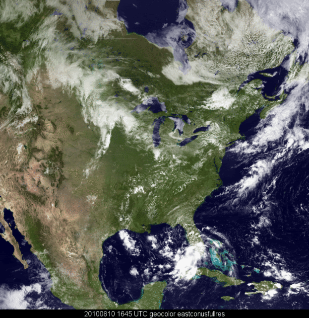
It is looking much better today on satellite with banding now evident in all quadrants. I do expect this to be designated a TD later tonight and probably Danielle tomorrow.

How strong and where are just big IFs right now.........Matagorda to Pensacola should pay close attention...


Personal Forecast Disclaimer:
The posts in this forum are NOT official forecast and should not be used as such. They are just the opinion of the poster and may or may not be backed by sound meteorological data. They are NOT endorsed by any professional institution or storm2k.org. For official information, please refer to the NHC and NWS products.
0 likes   

User avatar
ronjon
Category 5
Category 5
Posts: 4822
Joined: Fri Aug 19, 2005 5:17 pm
Location: Hernando Beach, FL

Re: ATL: INVEST 94L - Discussion

#489 Postby ronjon » Tue Aug 10, 2010 12:13 pm

Definitely wrapping up now with a nice convective burst over the center. Overall convective mass drifting north over the LLC. Dry air is starting to retreat with the ULL juicing up the atmosphere to the north of the center. All systems go. Awaiting the pressure falls and winds ramping up to classify as a TD, probably by tonight.

http://www.rap.ucar.edu/weather/satellite/displaySat.php?region=TPA&itype=vis&size=large&endDate=20100716&endTime=-1&duration=3
0 likes   

User avatar
MiamiHurricanes10
S2K Supporter
S2K Supporter
Posts: 260
Joined: Mon Jul 19, 2010 7:56 pm
Location: Miami, Florida

Re: ATL: INVEST 94L - Discussion

#490 Postby MiamiHurricanes10 » Tue Aug 10, 2010 12:14 pm

Spiral bands developing with 94L.

Image
0 likes   

User avatar
dixiebreeze
S2K Supporter
S2K Supporter
Posts: 5140
Joined: Wed Sep 03, 2003 5:07 pm
Location: crystal river, fla.

Re: ATL: INVEST 94L - Discussion

#491 Postby dixiebreeze » Tue Aug 10, 2010 12:17 pm

I'm a bit concerned about a possible 1985 Elena scenario, when she sat just off shore of the fla. Big Bend area and spun for a whole weekend, giving us the dirty side of the wind and surge.
Last edited by dixiebreeze on Tue Aug 10, 2010 12:23 pm, edited 1 time in total.
0 likes   

User avatar
DTWright
Tropical Low
Tropical Low
Posts: 37
Age: 65
Joined: Sun Jun 27, 2010 4:48 pm
Location: ( AKA Sabanic ) Mobile, AL
Contact:

Re: ATL: INVEST 94L - Discussion

#492 Postby DTWright » Tue Aug 10, 2010 12:19 pm

Definitely looks as though it is beginning to wrap up . .
0 likes   

tolakram
Admin
Admin
Posts: 20009
Age: 62
Joined: Sun Aug 27, 2006 8:23 pm
Location: Florence, KY (name is Mark)

Re: ATL: INVEST 94L - Discussion

#493 Postby tolakram » Tue Aug 10, 2010 12:22 pm

Loop: http://wwwghcc.msfc.nasa.gov/cgi-bin/ge ... mframes=15

Speed that up and you can clearly see the sloppy LLC moving SW toward the convection.
0 likes   
M a r k
- - - - -
Join us in chat: Storm2K Chatroom Invite. Android and IOS apps also available.

The posts in this forum are NOT official forecasts and should not be used as such. Posts are NOT endorsed by any professional institution or STORM2K.org. For official information and forecasts, please refer to NHC and NWS products.

Sanibel
Category 5
Category 5
Posts: 10375
Joined: Mon Aug 30, 2004 11:06 pm
Location: Offshore SW Florida

Re: ATL: INVEST 94L - Discussion

#494 Postby Sanibel » Tue Aug 10, 2010 12:26 pm

Winds picked up to near TS force here in heavy downpours.
0 likes   

User avatar
HURAKAN
Professional-Met
Professional-Met
Posts: 46086
Age: 38
Joined: Thu May 20, 2004 4:34 pm
Location: Key West, FL
Contact:

#495 Postby HURAKAN » Tue Aug 10, 2010 12:27 pm

Image

Latest
0 likes   

Sanibel
Category 5
Category 5
Posts: 10375
Joined: Mon Aug 30, 2004 11:06 pm
Location: Offshore SW Florida

Re: ATL: INVEST 94L - Discussion

#496 Postby Sanibel » Tue Aug 10, 2010 12:35 pm

Rain burst brought the winds down to the surface. Now we are back to 10-15Kts in steady wind-blown rain.
0 likes   

User avatar
AdamFirst
S2K Supporter
S2K Supporter
Posts: 2491
Age: 36
Joined: Thu Aug 14, 2008 10:54 am
Location: Port Saint Lucie, FL

#497 Postby AdamFirst » Tue Aug 10, 2010 12:40 pm

Rain bands beginning to build to the south with more frequency, heading this way. Overall structure beginning to look very good at least on radar.
0 likes   
Dolphins Marlins Canes Golden Panthers HEAT
Andrew 1992 - Irene 1999 - Frances 2004 - Jeanne 2004 - Wilma 2005 - Fay 2008 - Isaac 2012 - Matthew 2016 - Irma 2017 - Dorian 2019 - Ian 2022 - Nicole 2022 - Milton 2024

Ikester
Professional-Met
Professional-Met
Posts: 361
Age: 39
Joined: Mon Jun 21, 2010 5:00 pm
Location: Jacksonville, FL

Re: ATL: INVEST 94L - Discussion

#498 Postby Ikester » Tue Aug 10, 2010 12:41 pm

The system to me seems to have halted the southwest movement and if anything is due west or a hair north of due west. Anybody?
0 likes   

Sanibel
Category 5
Category 5
Posts: 10375
Joined: Mon Aug 30, 2004 11:06 pm
Location: Offshore SW Florida

Re: ATL: INVEST 94L - Discussion

#499 Postby Sanibel » Tue Aug 10, 2010 12:43 pm

Creeping a hair north of west in my opinion.


Look at this heavy band forming over the Keys:


http://radar.weather.gov/ridge/radar.php?rid=BYX&product=NCR&overlay=11101111&loop=yes


.
0 likes   

User avatar
ROCK
Category 5
Category 5
Posts: 9484
Age: 54
Joined: Tue Aug 17, 2004 7:30 am
Location: Kemah, Texas

Re: ATL: INVEST 94L - Discussion

#500 Postby ROCK » Tue Aug 10, 2010 12:43 pm

tolakram wrote:Loop: http://wwwghcc.msfc.nasa.gov/cgi-bin/ge ... mframes=15

Speed that up and you can clearly see the sloppy LLC moving SW toward the convection.


yep...needs to stack with its MLC, once it does then it should really get going...
0 likes   


Return to “2010”

Who is online

Users browsing this forum: Google Adsense [Bot] and 3 guests