I'm about to go into hybernation until something real develops
ATL: Ex INVEST 93L - Discussion
Moderator: S2k Moderators
- HURAKAN
- Professional-Met
- Posts: 46086
- Age: 38
- Joined: Thu May 20, 2004 4:34 pm
- Location: Key West, FL
- Contact:
Re: ATL: INVEST 93L - Discussion
I'm about to go into hybernation until something real develops
0 likes
- MiamiHurricanes10
- S2K Supporter
- Posts: 260
- Joined: Mon Jul 19, 2010 7:56 pm
- Location: Miami, Florida
Re: ATL: INVEST 93L - Discussion
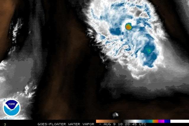
wxman57 wrote:Convection is dying out and shear seems to be on the increase. Looks like it's already past its peak as far as intensity.
Shear is conducive for development. Upper level winds are currently just 10 knots. Plus it has an anticyclone. This is in between two upper level lows which would suggest that upper level ridging should balloon in between. This by no means has gone "poof" just because convection waned slightly.
A little too quick to forget for my liking, there is still a high chance that this will become a tropical cyclone, all it needs in reality is a decent convective burst to get classified, the circulation remains in tact, closed, and well-defined.
0 likes
-
- Category 5
- Posts: 1794
- Joined: Wed Mar 03, 2010 6:20 am
- Location: Toms River, NJ
Re: ATL: INVEST 93L - Discussion
I had a feeling this one wouldn't develop and I was right. Danielle is not going to be some weak TS in the open Atlantic.
0 likes
- MiamiHurricanes10
- S2K Supporter
- Posts: 260
- Joined: Mon Jul 19, 2010 7:56 pm
- Location: Miami, Florida
Re: ATL: INVEST 93L - Discussion
hurricaneCW wrote:I had a feeling this one wouldn't develop and I was right. Danielle is not going to be some weak TS in the open Atlantic.
You're writing this off way too quickly. If it wasn't going to develop the NHC would not have a red circle around it.
0 likes
-
- Category 5
- Posts: 1794
- Joined: Wed Mar 03, 2010 6:20 am
- Location: Toms River, NJ
Re: ATL: INVEST 93L - Discussion
MiamiHurricanes10 wrote:hurricaneCW wrote:I had a feeling this one wouldn't develop and I was right. Danielle is not going to be some weak TS in the open Atlantic.
You're writing this off way too quickly. If it wasn't going to develop the NHC would not have a red circle around it.
They have a red circle because there is a well defined LLC with some convection. The problem is that the environment does not appear to be conducive for any organization. If it was, we would have had a TS by now. The shear and dry air are not going to allow anything to form. I think this one is history. 94L is the only game in town, but even that one looks very uncertain.
0 likes
I doubt its shear thats the problem right now, though its increasing, I can only imagine the set-up around it is rather stable at the moment, not dry per say but stable.
0 likes
Personal Forecast Disclaimer:
The posts in this forum are NOT official forecast and should not be used as such. They are just the opinion of the poster and may or may not be backed by sound meteorological data. They are NOT endorsed by any professional institution or storm2k.org. For official information, please refer to the NHC and NWS products
- MiamiHurricanes10
- S2K Supporter
- Posts: 260
- Joined: Mon Jul 19, 2010 7:56 pm
- Location: Miami, Florida
Re: ATL: INVEST 93L - Discussion
hurricaneCW wrote:MiamiHurricanes10 wrote:hurricaneCW wrote:I had a feeling this one wouldn't develop and I was right. Danielle is not going to be some weak TS in the open Atlantic.
You're writing this off way too quickly. If it wasn't going to develop the NHC would not have a red circle around it.
They have a red circle because there is a well defined LLC with some convection. The problem is that the environment does not appear to be conducive for any organization. If it was, we would have had a TS by now. The shear and dry air are not going to allow anything to form. I think this one is history. 94L is the only game in town, but even that one looks very uncertain.
Shear is not a problem, only about 10 knots. The only problem is the dry stable air it is surrounded by. And if the environment "does not appear conducive" please explain this from the 2:05 PM EDT TWD:
"ENVIRONMENTAL CONDITIONS APPEAR FAVORABLE FOR THIS SYSTEM TO BECOME A TROPICAL CYCLONE DURING THE NEXT COUPLE OF DAYS".
I do admit, this currently is not a tropical cyclone due to the lack of convection, but all these write-offs are very premature.
0 likes
Re: ATL: INVEST 93L - Discussion
hurricaneCW wrote:I had a feeling this one wouldn't develop and I was right. Danielle is not going to be some weak TS in the open Atlantic.
You really cant say that a name will be or wont b a major. It just depends. Is it possible you just think this one wont develop because you want your major D name? Im still hopeful this is our 4th NS. Just a little pop of good convection and it should be ready. I agree with Miamihurricanes, we just need some patience. Ill right it off when the NHC does.
0 likes
Looks like this one is gonna struggle now, can't rule out development as it starts to move away to the north again as systems like this seem to do better when they move northwards I've noticed.
0 likes
Personal Forecast Disclaimer:
The posts in this forum are NOT official forecast and should not be used as such. They are just the opinion of the poster and may or may not be backed by sound meteorological data. They are NOT endorsed by any professional institution or storm2k.org. For official information, please refer to the NHC and NWS products
- StormTracker
- S2K Supporter
- Posts: 2903
- Age: 59
- Joined: Thu Jun 29, 2006 6:06 am
- Location: Quail Heights(Redlands), FL.
Re: ATL: INVEST 93L - Discussion
Doesn't it have a better chance of moving further west now before heading north now that it's so weak, or are the steering currents that strong that it doesn't matter?
0 likes
Something's wrong when you regret, things that haven't happened yet!
- brunota2003
- S2K Supporter
- Posts: 9476
- Age: 34
- Joined: Sat Jul 30, 2005 9:56 pm
- Location: Stanton, KY...formerly Havelock, NC
- Contact:
- MiamiHurricanes10
- S2K Supporter
- Posts: 260
- Joined: Mon Jul 19, 2010 7:56 pm
- Location: Miami, Florida
Re: ATL: INVEST 93L - Discussion
StormTracker wrote:Doesn't it have a better chance of moving further west now before heading north now that it's so weak, or are the steering currents that strong that it doesn't matter?
Not in this case. A strong shortwave trough behind the one that produced 94L will be causing 93L to recurve.
Last edited by MiamiHurricanes10 on Mon Aug 09, 2010 6:46 pm, edited 1 time in total.
0 likes
- cycloneye
- Admin
- Posts: 145286
- Age: 68
- Joined: Thu Oct 10, 2002 10:54 am
- Location: San Juan, Puerto Rico
Re: ATL: INVEST 93L - Discussion
8 PM EDT TWO stays at 70%
SHOWER AND THUNDERSTORM ACTIVITY ASSOCIATED WITH A LOW PRESSURE AREA
LOCATED ABOUT 875 MILES EAST-NORTHEAST OF THE LEEWARDS ISLANDS
REMAINS LIMITED AND DISORGANIZED. ENVIRONMENTAL CONDITIONS ARE
EXPECTED TO BE MARGINALLY CONDUCIVE FOR DEVELOPMENT OF THIS
DISTURBANCE...AND ANY SIGNIFICANT ORGANIZATION OF THE THUNDERSTORMS
COULD RESULT IN THE FORMATION OF A TROPICAL CYCLONE. THE LOW IS
MOVING WEST-NORTHWESTWARD AT 10 TO 15 MPH AND IS EXPECTED TO TURN
NORTHWESTWARD AND NORTHWARD DURING THE NEXT COUPLE OF DAYS. THERE
IS A HIGH CHANCE...70 PERCENT...OF THIS SYSTEM BECOMING A TROPICAL
CYCLONE DURING THE NEXT 48 HOURS.
0 likes
Visit the Caribbean-Central America Weather Thread where you can find at first post web cams,radars
and observations from Caribbean basin members Click Here
I'm just a touch surprised they've kept it at 70%, I know the models do still suggest some sort of development and whilst that may yet happen perhaps the best chance may have already gone by....probably will have another shot when its on the recurve pattern...but I'd put the chances probably down at 30% now.
Clearly something isn't right with this, looks like another good call from the models which didn't do alot with this one.
0 likes
Personal Forecast Disclaimer:
The posts in this forum are NOT official forecast and should not be used as such. They are just the opinion of the poster and may or may not be backed by sound meteorological data. They are NOT endorsed by any professional institution or storm2k.org. For official information, please refer to the NHC and NWS products
- cycloneye
- Admin
- Posts: 145286
- Age: 68
- Joined: Thu Oct 10, 2002 10:54 am
- Location: San Juan, Puerto Rico
Re: ATL: INVEST 93L - Discussion
I was also surprised by the % staying the same. Maybe they see something favorable in the next couple of days that we are not seeing now.
0 likes
Visit the Caribbean-Central America Weather Thread where you can find at first post web cams,radars
and observations from Caribbean basin members Click Here
Who is online
Users browsing this forum: No registered users and 3 guests