

Well it has decreased, you're right, Aric, and its shifting but it's still around 20-25kts over the frontal boundary, which is probably down from 25-30kts, not a huge difference, granted it has really dropped away further north.
Frank, I'd not look for development of the ULL, its the low just to the W of SW Florida is the one to watch, but its a messy set-up.
ATL: EX-Tropical Depression FIVE - Discussion
Moderator: S2k Moderators
0 likes
Personal Forecast Disclaimer:
The posts in this forum are NOT official forecast and should not be used as such. They are just the opinion of the poster and may or may not be backed by sound meteorological data. They are NOT endorsed by any professional institution or storm2k.org. For official information, please refer to the NHC and NWS products
The posts in this forum are NOT official forecast and should not be used as such. They are just the opinion of the poster and may or may not be backed by sound meteorological data. They are NOT endorsed by any professional institution or storm2k.org. For official information, please refer to the NHC and NWS products
Re: ATL: INVEST 94L - Discussion
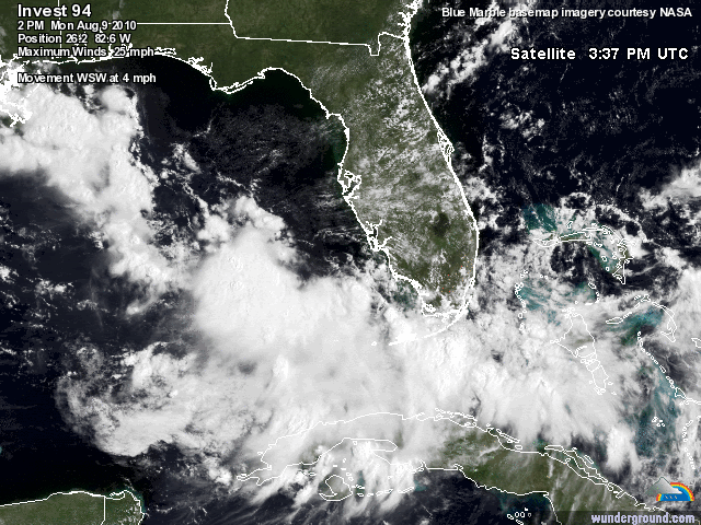
There's no question of a circulation center at the surface. Numerous observations in the eastern Gulf and Florida confirm this. But the LLC is broad and lacking convection so far. Good chance it becomes a TD or weak TS before landfall in SE LA on Thursday morning.
Thanks for the update, wxman57 (I've not had the chance to check things today), though as KWT said it's a messy situation, though that feeder band/frontal trough is extensive and in fact extends all the way to AR and beyond...
As the system crossed this area yesterday we did get pounded - at least I did, driving back from the Wal Mart (lol)...
Not much wind, but did it rain (about 3-5 inches in my area)...
The entire area is moving west so as you said perhaps something before it reaches TX...
Frank
0 likes
-
Dean4Storms
- S2K Supporter

- Posts: 6358
- Age: 63
- Joined: Sun Aug 31, 2003 1:01 pm
- Location: Miramar Bch. FL
-
petit_bois

- Tropical Storm

- Posts: 227
- Joined: Tue Jun 22, 2010 12:04 pm
- Location: Petit Bois Island Mississippi
Bacause of the proximity to land, fact that surface low is established and shear is expected to relax.. I would have to say 50% or higher on next TWO...maybe higher. I beleive it's going to be TD buy tomprrow night so I guess that means I'm at 100% but what do I know?
Lots of hot water.. slow forward speed... relaxing shear... mid August... hmmm
Lots of hot water.. slow forward speed... relaxing shear... mid August... hmmm
0 likes
Resident of the Atlantic Basin's Major Hurricane Hit Capital!
Camille (200+winds), Frederic, Goerges, Katrina... and many many more.
Disclaimer: I'm likely the smartest guy here... but I have no idea where a tropical cyclone will go. I suggest you take my opinion as a grain of salt. I suggest you look to the National Hurricane Center for accurate info.
Camille (200+winds), Frederic, Goerges, Katrina... and many many more.
Disclaimer: I'm likely the smartest guy here... but I have no idea where a tropical cyclone will go. I suggest you take my opinion as a grain of salt. I suggest you look to the National Hurricane Center for accurate info.


-
Stormcenter
- S2K Supporter
- Posts: 6689
- Joined: Wed Sep 03, 2003 11:27 am
- Location: Houston, TX


-
bamajammer4eva
- Category 4

- Posts: 907
- Joined: Sun Apr 18, 2010 3:21 am
- Location: Ozark, AL
Re: ATL: INVEST 94L - Discussion
Comanche wrote:TCHP not all that much to write home about either-
Not bad according to this image

0 likes
-
Weatherfreak000
Re: ATL: INVEST 94L - Discussion

The environment is about to become conducive. I would up the percentages maybe at 8. The ULL looks to be in perfect position to flare convection for this. I'm feeling much better on development chances....given the ULL doesn't bully.
0 likes


Its slowly getting better organised but it still looks very frontal to me...
Funnily enough it looks like the formative phase of Dianmu in the WPAC which formed in a very similar set-up with it seemingly stemming from a ULL.
Funnily enough it looks like the formative phase of Dianmu in the WPAC which formed in a very similar set-up with it seemingly stemming from a ULL.
0 likes
Personal Forecast Disclaimer:
The posts in this forum are NOT official forecast and should not be used as such. They are just the opinion of the poster and may or may not be backed by sound meteorological data. They are NOT endorsed by any professional institution or storm2k.org. For official information, please refer to the NHC and NWS products
The posts in this forum are NOT official forecast and should not be used as such. They are just the opinion of the poster and may or may not be backed by sound meteorological data. They are NOT endorsed by any professional institution or storm2k.org. For official information, please refer to the NHC and NWS products


Re: ATL: INVEST 94L - Discussion
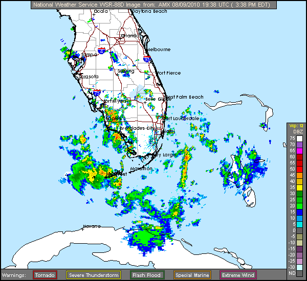
Lowest land based air pressure at Ft Myers at 4 PM. Sarasota was at 29.86.
FT MYERS LGT RAIN 84 77 79 S6 29.85F
FT MYERS LGT RAIN 84 77 79 S6 29.85F
0 likes
Fair enough Hurakan, probably just the old remains in that case, I still think it needs to seperate somewhat from that old frontal boundary, esp given its still quite strong right now and producing widespread convection...however I have seen such development occur, and given its in the Gulf the NHC will be far more keen to upgrade a marginal system.
0 likes
Personal Forecast Disclaimer:
The posts in this forum are NOT official forecast and should not be used as such. They are just the opinion of the poster and may or may not be backed by sound meteorological data. They are NOT endorsed by any professional institution or storm2k.org. For official information, please refer to the NHC and NWS products
The posts in this forum are NOT official forecast and should not be used as such. They are just the opinion of the poster and may or may not be backed by sound meteorological data. They are NOT endorsed by any professional institution or storm2k.org. For official information, please refer to the NHC and NWS products

Its part of the same old frontal boundary, so whilst its not from 94L its from the same system is somewhat helping to spark 94L off.
0 likes
Personal Forecast Disclaimer:
The posts in this forum are NOT official forecast and should not be used as such. They are just the opinion of the poster and may or may not be backed by sound meteorological data. They are NOT endorsed by any professional institution or storm2k.org. For official information, please refer to the NHC and NWS products
The posts in this forum are NOT official forecast and should not be used as such. They are just the opinion of the poster and may or may not be backed by sound meteorological data. They are NOT endorsed by any professional institution or storm2k.org. For official information, please refer to the NHC and NWS products

Who is online
Users browsing this forum: No registered users and 110 guests