ATL: Ex COLIN - Discussion
Moderator: S2k Moderators
-
hurricaneCW
- Category 5

- Posts: 1799
- Joined: Wed Mar 03, 2010 6:20 am
- Location: Toms River, NJ
Re: ATL : Tropical Storm Colin - DISCUSSION
It's seems to be moving very slowly right now. Is it possible that it could remain moving very slowly and possible miss the weakness that it won't recurve so quickly.
0 likes
-
srainhoutx

- S2K Supporter

- Posts: 6919
- Age: 68
- Joined: Sun Jan 14, 2007 11:34 am
- Location: Haywood County, NC
- Contact:
Re: ATL : Tropical Storm Colin - DISCUSSION
If I recall correctly, the NHC mentioned in the Advisories that a slow down was expected as this feature neared the Leewards.
0 likes
Carla/Alicia/Jerry(In The Eye)/Michelle/Charley/Ivan/Dennis/Katrina/Rita/Wilma/Ike/Harvey
Member: National Weather Association
Wx Infinity Forums
http://wxinfinity.com/index.php
Facebook.com/WeatherInfinity
Twitter @WeatherInfinity
Member: National Weather Association
Wx Infinity Forums
http://wxinfinity.com/index.php
Facebook.com/WeatherInfinity
Twitter @WeatherInfinity


Re: ATL : Tropical Storm Colin - DISCUSSION
hurricaneCW wrote:It's seems to be moving very slowly right now. Is it possible that it could remain moving very slowly and possible miss the weakness that it won't recurve so quickly.
Nah its pretty much certain this will scoop up, what your seeing is partly the fact its finally escaping the strong low level surge and also the fact that the westerly shear is constantly trying to blow the convection away...
No doubt its slowed though, probably will move increasingly northwards from now on.
Redevelopment is looking increasingly likely as well now, esp once it starts to lift up to the north, going to be interesting to see how strong it gets...I'll go for 55kts right now.
0 likes
Personal Forecast Disclaimer:
The posts in this forum are NOT official forecast and should not be used as such. They are just the opinion of the poster and may or may not be backed by sound meteorological data. They are NOT endorsed by any professional institution or storm2k.org. For official information, please refer to the NHC and NWS products
The posts in this forum are NOT official forecast and should not be used as such. They are just the opinion of the poster and may or may not be backed by sound meteorological data. They are NOT endorsed by any professional institution or storm2k.org. For official information, please refer to the NHC and NWS products
-
hurricaneCW
- Category 5
- Posts: 1799
- Joined: Wed Mar 03, 2010 6:20 am
- Location: Toms River, NJ
Re: ATL : Tropical Storm Colin - DISCUSSION
Ok no problem, let's just see what Colin will do while at sea, it might even affect Bermuda. It's only August 4. I'm hoping for a tropical storm up here this season either from a weakening hurricane or from a near impact. Probably have to wait until September for a chance to see something like that.
0 likes
-
Dean4Storms
- S2K Supporter
- Posts: 6358
- Age: 63
- Joined: Sun Aug 31, 2003 1:01 pm
- Location: Miramar Bch. FL
-
srainhoutx
- S2K Supporter
- Posts: 6919
- Age: 68
- Joined: Sun Jan 14, 2007 11:34 am
- Location: Haywood County, NC
- Contact:
Re: ATL : Tropical Storm Colin - DISCUSSION
0 likes
Carla/Alicia/Jerry(In The Eye)/Michelle/Charley/Ivan/Dennis/Katrina/Rita/Wilma/Ike/Harvey
Member: National Weather Association
Wx Infinity Forums
http://wxinfinity.com/index.php
Facebook.com/WeatherInfinity
Twitter @WeatherInfinity
Member: National Weather Association
Wx Infinity Forums
http://wxinfinity.com/index.php
Facebook.com/WeatherInfinity
Twitter @WeatherInfinity
-
ozonepete
- Professional-Met

- Posts: 4743
- Joined: Mon Sep 07, 2009 3:23 pm
- Location: From Ozone Park, NYC / Now in Brooklyn, NY
Re: ATL : Tropical Storm Colin - DISCUSSION
wxman57 wrote:Looks like we'll have a real TS Colin by this time tomorrow or more likely on Friday. Could even be a hurricane over the weekend. Good news is that it looks like it'll pass between Bermuda and the East U.S. Coast.
I agree. It's really starting to wind up because it's losing the SE to NW elongation and starting to get symmetry.
0 likes
-
ozonepete
- Professional-Met
- Posts: 4743
- Joined: Mon Sep 07, 2009 3:23 pm
- Location: From Ozone Park, NYC / Now in Brooklyn, NY
Re: ATL : Tropical Storm Colin - DISCUSSION
srainhoutx wrote:If I recall correctly, the NHC mentioned in the Advisories that a slow down was expected as this feature neared the Leewards.
A slowdown almost always occurs as a TC enters a recurve. Due to conservation of angular momentum, it slows down going into a curve and accelerates out of it. So yeah, it should be slowing down if it hasn't already.
0 likes
-
TwisterFanatic

- Category 5
- Posts: 1041
- Joined: Mon Jun 28, 2010 12:43 pm
- Location: Sallisaw, Oklahoma
Re: ATL : Tropical Storm Colin - DISCUSSION

0 likes
Personal Forecast Disclaimer:
The posts in this forum are NOT official forecast and should not be used as such. They are just the opinion of the poster and may or may not be backed by sound meteorological data. They are NOT endorsed by any professional institution or storm2k.org. For official information, please refer to the NHC and NWS products.
The posts in this forum are NOT official forecast and should not be used as such. They are just the opinion of the poster and may or may not be backed by sound meteorological data. They are NOT endorsed by any professional institution or storm2k.org. For official information, please refer to the NHC and NWS products.
Oh this will probably be a Code red soon I'd imagine, its looking very good and I suspect we may have not just TD Colin but TS Colin in the next 12-18hrs...unless the shear hits it harder again.
Models doing a good job with this one it has to be said!
Models doing a good job with this one it has to be said!
0 likes
Personal Forecast Disclaimer:
The posts in this forum are NOT official forecast and should not be used as such. They are just the opinion of the poster and may or may not be backed by sound meteorological data. They are NOT endorsed by any professional institution or storm2k.org. For official information, please refer to the NHC and NWS products
The posts in this forum are NOT official forecast and should not be used as such. They are just the opinion of the poster and may or may not be backed by sound meteorological data. They are NOT endorsed by any professional institution or storm2k.org. For official information, please refer to the NHC and NWS products

Re:
KWT wrote:Oh this will probably be a Code red soon I'd imagine, its looking very good and I suspect we may have not just TD Colin but TS Colin in the next 12-18hrs...unless the shear hits it harder again.
Models doing a good job with this one it has to be said!
seems recon is on their way, just found obs4 for this flight. Can you double check it for me?
0 likes
-
cycloneye

- Admin

- Posts: 149686
- Age: 69
- Joined: Thu Oct 10, 2002 10:54 am
- Location: San Juan, Puerto Rico
Re: ATL : Tropical Storm Colin - DISCUSSION
Up to 40%
ABNT20 KNHC 042338
TWOAT
TROPICAL WEATHER OUTLOOK
NWS TPC/NATIONAL HURRICANE CENTER MIAMI FL
800 PM EDT WED AUG 4 2010
FOR THE NORTH ATLANTIC...CARIBBEAN SEA AND THE GULF OF MEXICO...
SATELLITE IMAGES INDICATE THAT THE CLOUD PATTERN ASSOCIATED WITH THE
REMNANTS OF TROPICAL STORM COLIN IS GRADUALLY BECOMING BETTER
ORGANIZED BUT THE SYSTEM LACKS A WELL-DEFINED CENTER. TROPICAL
STORM FORCE WINDS ARE ALREADY OCCURRING OVER WATER WELL TO THE
NORTHEAST OF THE LEEWARD ISLANDS AND ALTHOUGH UPPER LEVEL WINDS ARE
NOT FAVORABLE FOR SIGNIFICANT DEVELOPMENT...THE SYSTEM HAS THE
POTENTIAL TO REGAIN TROPICAL STORM STATUS ON THURSDAY AS IT MOVES
TOWARD THE WEST-NORTHWEST OR NORTHWEST AT 20 TO 25 MPH. THERE IS A
MEDIUM CHANCE...40 PERCENT...OF THIS SYSTEM BECOMING A TROPICAL
CYCLONE DURING THE NEXT 48 HOURS.
A TROPICAL WAVE IS PRODUCING CLOUDINESS AND THUNDERSTORMS BETWEEN
COLOMBIA AND JAMAICA. ALTHOUGH THIS ACTIVITY HAS NOT BECOME ANY
BETTER ORGANIZED DURING THE PAST SEVERAL HOURS...SOME DEVELOPMENT
IS POSSIBLE DURING THE NEXT DAY OR TWO BEFORE THE WAVE BEGINS TO
INTERACT WITH CENTRAL AMERICA. THERE IS A LOW CHANCE...20
PERCENT...OF THIS SYSTEM BECOMING A TROPICAL CYCLONE DURING THE
NEXT 48 HOURS.
ELSEWHERE...TROPICAL CYCLONE FORMATION IS NOT EXPECTED DURING THE
NEXT 48 HOURS.
$$
FORECASTER AVILA
0 likes
Visit the Caribbean-Central America Weather Thread where you can find at first post web cams,radars
and observations from Caribbean basin members Click Here
and observations from Caribbean basin members Click Here
-
thetruesms

- Professional-Met
- Posts: 844
- Age: 42
- Joined: Thu Aug 16, 2007 1:14 pm
- Location: Tallahasee, FL
- Contact:
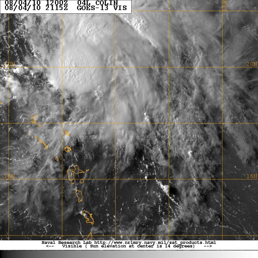
Well, what a difference a good convective blowup makes, amirite? Through the last visible, it looked pretty clearly to still be a sharp wave axis, but it's made some good progress today. I don't know that the next recon flight will find something interesting, but I think we've got at least a decent shot tomorrow afternoon.
0 likes

Re: ATL : Tropical Storm Colin - DISCUSSION
How high is the belief that this "storm" will go between Bermuda and the East coast? Is there no likelihood that it will go toward S Fl? (friends are there now)
0 likes
-
SootyTern
- S2K Supporter
- Posts: 316
- Age: 57
- Joined: Sun Sep 05, 2004 5:09 pm
- Location: NYC (formerly Homestead, FL)
Seems like the ULL is retreating to the north a bit and is no longer directly in the path of the storm.
http://www.ssd.noaa.gov/goes/east/tatl/flash-wv.html
http://www.ssd.noaa.gov/goes/east/tatl/flash-wv.html
0 likes
-
AJC3

- Admin
- Posts: 4156
- Age: 62
- Joined: Tue Aug 31, 2004 7:04 pm
- Location: Ballston Spa, New York
- Contact:
Re: ATL : Tropical Storm Colin - DISCUSSION
sunnyday wrote:How high is the belief that this "storm" will go between Bermuda and the East coast? Is there no likelihood that it will go toward S Fl? (friends are there now)
There just won't be any sort of ridging to drive it that far westward. A pretty large col (breach) in between the SE CONUS and Bermuda ridges has been consistently forecast to develop and widen to between about 65/70W and 80W. Whatever Colin becomes should continue to turn northward around the west side of the Bermuda ridge.
0 likes
-
Ivanhater

- Storm2k Moderator

- Posts: 11222
- Age: 39
- Joined: Fri Jul 01, 2005 8:25 am
- Location: Pensacola
Re: ATL : Tropical Storm Colin - DISCUSSION
This looks to have a good shot at becoming a hurricane. Model guidance is in really good agreement in strengthening Colin...
0 likes
Michael
-
cycloneye
- Admin
- Posts: 149686
- Age: 69
- Joined: Thu Oct 10, 2002 10:54 am
- Location: San Juan, Puerto Rico
Re: ATL : Tropical Storm Colin - DISCUSSION
Hmmm, the wind directions here in San Juan have been all over the place since this afternoon, the latest from the NW.
http://weather.noaa.gov/weather/current/TJSJ.html
2010.08.04 2356 UTC
Wind from the NW (320 degrees) at 6 MPH (5 KT)
Visibility 10 mile(s)
Sky conditions partly cloudy
Temperature 84.0 F (28.9 C)
Dew Point 75.9 F (24.4 C)
Relative Humidity 76%
Pressure (altimeter) 29.89 in. Hg (1012 hPa)
Pressure tendency 0.03 inches (1.1 hPa) higher than three hours ago
0 likes
Visit the Caribbean-Central America Weather Thread where you can find at first post web cams,radars
and observations from Caribbean basin members Click Here
and observations from Caribbean basin members Click Here
Who is online
Users browsing this forum: No registered users and 296 guests