ATL: Ex COLIN - Discussion
Moderator: S2k Moderators
- Texas Snowman
- Storm2k Moderator

- Posts: 6197
- Joined: Fri Jan 25, 2008 11:29 am
- Location: Denison, Texas
Re: ATL : INVEST 91L - DISCUSSION
Days and days to go, IMO a myriad of outcomes are possible out of this one...
Not buying nothing yet.
Not buying nothing yet.
0 likes
The above post and any post by Texas Snowman is NOT an official forecast and should not be used as such. It is just the opinion of the poster and may or may not be backed by sound meteorological data. It is NOT endorsed by any professional institution including storm2k.org. For official information, please refer to NWS products.
- gatorcane
- S2K Supporter

- Posts: 23708
- Age: 48
- Joined: Sun Mar 13, 2005 3:54 pm
- Location: Boca Raton, FL
Re: ATL : INVEST 91L - DISCUSSION
Texas Snowman wrote:Days and days to go, IMO a myriad of outcomes are possible out of this one...
Not buying nothing yet.
I'm also biased towards it become a fish as I am heading to the FL Keys this weekend....
If this were to make a run at the Fl Keys, though it would impact them around the Mon.-Tues. timeframe it would put a damper in the weekend nonetheless...
0 likes
- Texas Snowman
- Storm2k Moderator

- Posts: 6197
- Joined: Fri Jan 25, 2008 11:29 am
- Location: Denison, Texas
Re: ATL : INVEST 91L - DISCUSSION
gatorcane wrote:Texas Snowman wrote:Days and days to go, IMO a myriad of outcomes are possible out of this one...
Not buying nothing yet.
I'm also biased towards it become a fish as I am heading to the FL Keys this weekend....
Gatorcane, you know that a trip to the Keys in August can be dicey!
Hopefully, this will be a fish storm.
0 likes
The above post and any post by Texas Snowman is NOT an official forecast and should not be used as such. It is just the opinion of the poster and may or may not be backed by sound meteorological data. It is NOT endorsed by any professional institution including storm2k.org. For official information, please refer to NWS products.
-
Weatherfreak000
At this point when they pull the trigger is just semantics. Later on in post season they can always modify that sort of thing. We know this is going to likely develop.
My question to YOU, Airforcemet, is what if the system is going to run into an inevitable shear zone, but is at least as good looking as 91L now....or perhaps 92L earlier in the season is a good parallel because it was likely developed but was inevitably going to be hit with the shear. Doesn't that make them as an Organization liable for mistakes? I mean...there is a reason we care what the NHC does after all, me saying it's a TD means nothing.
My question to YOU, Airforcemet, is what if the system is going to run into an inevitable shear zone, but is at least as good looking as 91L now....or perhaps 92L earlier in the season is a good parallel because it was likely developed but was inevitably going to be hit with the shear. Doesn't that make them as an Organization liable for mistakes? I mean...there is a reason we care what the NHC does after all, me saying it's a TD means nothing.
Last edited by Weatherfreak000 on Sun Aug 01, 2010 10:32 pm, edited 1 time in total.
0 likes
- thetruesms
- Professional-Met

- Posts: 844
- Age: 42
- Joined: Thu Aug 16, 2007 1:14 pm
- Location: Tallahasee, FL
- Contact:
Re: ATL : INVEST 91L - DISCUSSION
Wow, an ASCAT pass that didn't completely whiff!Ivanhater wrote:ASCAT suggests further north
[img]http://www.knmi.nl/scatterometer/ascat_ear_25_prod/products/20100801_23_5.gif[img]
0 likes
-
Air Force Met
- Military Met

- Posts: 4372
- Age: 57
- Joined: Tue Jul 08, 2003 9:30 am
- Location: Roan Mountain, TN
Re:
Weatherfreak000 wrote:At this point when they pull the trigger is just semantics. Later on in post season they can always modify that sort of thing. We know this is going to likely develop.
My question to YOU, Airforcemet, is what if the system is going to run into an inevitable shear zone, but is at least as good looking as 91L now....or perhaps 92L earlier in the season is a good parallel. Doesn't that make them as an Organization liable for mistakes? I mean...there is a reason we care what the NHC does after all, me saying it's a TD means nothing.
Not sure exactly what your question is.
0 likes
- gatorcane
- S2K Supporter

- Posts: 23708
- Age: 48
- Joined: Sun Mar 13, 2005 3:54 pm
- Location: Boca Raton, FL
Re: ATL : INVEST 91L - DISCUSSION
Texas Snowman wrote:gatorcane wrote:Texas Snowman wrote:Days and days to go, IMO a myriad of outcomes are possible out of this one...
Not buying nothing yet.
I'm also biased towards it become a fish as I am heading to the FL Keys this weekend....
Gatorcane, you know that a trip to the Keys in August can be dicey!
Hopefully, this will be a fish storm.
Yeah, I'm about 80% confident I will be OKAY in the keys at this point, but will watch this in case models do change.
0 likes
- cycloneye
- Admin

- Posts: 149730
- Age: 69
- Joined: Thu Oct 10, 2002 10:54 am
- Location: San Juan, Puerto Rico
Re: ATL : INVEST 91L - DISCUSSION
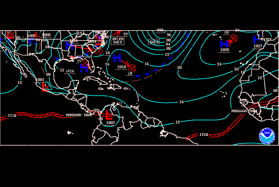
00z Surface analysis. Low is still partially in the ITCZ but eventually, it will get out of the convergence zone.


0 likes
Visit the Caribbean-Central America Weather Thread where you can find at first post web cams,radars
and observations from Caribbean basin members Click Here
and observations from Caribbean basin members Click Here
- SouthFloridawx
- S2K Supporter

- Posts: 8346
- Age: 47
- Joined: Tue Jul 26, 2005 1:16 am
- Location: Sarasota, FL
- Contact:
Re: ATL : INVEST 91L - DISCUSSION
We'll have to wait for the model run... after it's official for the models to get a better handle on this anyway. I wouldn't set anything in stone at this point. Who knows what that Shortwave trough will do later on in the week. So many if's at this point, I would set anything into stone.
0 likes
Re: ATL : INVEST 91L - DISCUSSION
Yesterday the models had 91L moving west towards Florida. Today towards Bermuda.tomorrow who knows. This system has to develop first.That ULL NNE of Puerto Rico will play havac on 91L thats for sure.
0 likes
Re: ATL : INVEST 91L - DISCUSSION
the nice convection earlier tops have warmed.....some new cold top forming to the west but not a potent as before. I would say about a 2/3rds out of the ITCZ...still drawing some moisture from the south...TD tomorrow for sure....IMO its not going to ramp up as quickly as some of the models are predicting however I will withhold judegment until the EURO tonight....still has some work to do...
0 likes
- gatorcane
- S2K Supporter

- Posts: 23708
- Age: 48
- Joined: Sun Mar 13, 2005 3:54 pm
- Location: Boca Raton, FL
Re: ATL : INVEST 91L - DISCUSSION
ROCK wrote:the nice convection earlier tops have warmed.....some new cold top forming to the west but not a potent as before. I would say about a 2/3rds out of the ITCZ...still drawing some moisture from the south...TD tomorrow for sure....IMO its not going to ramp up as quickly as some of the models are predicting however I will withhold judegment until the EURO tonight....still has some work to do...
The 00Z GFS has backed WAAYYY off on development within the next 12 hours....
0 likes
- Gustywind
- Category 5

- Posts: 12334
- Joined: Mon Sep 03, 2007 7:29 am
- Location: Baie-Mahault, GUADELOUPE
I don't know how people are saying Fish (or not) while we have not at least a TD in our hands??? We should focus in my humble opinion first on the intensity much more than the track! We have enough time to confirmed that or not.
Regardless, us in the islands should be on our guard during the next couple of days with this developping system 91L. I advice you to be vigilant all islanders of the Lesser Antilles, be aware.
Gustywind
Regardless, us in the islands should be on our guard during the next couple of days with this developping system 91L. I advice you to be vigilant all islanders of the Lesser Antilles, be aware.
Gustywind
0 likes
- cycloneye
- Admin

- Posts: 149730
- Age: 69
- Joined: Thu Oct 10, 2002 10:54 am
- Location: San Juan, Puerto Rico
Re:
Gustywind wrote:I don't know how people are saying Fish (or not) while we have not at least a TD in our hands??? We should focus in my humble opinion first on the intensity much more than the track! We have enough time to confirmed that or not.
Regardless, us in the islands should be on our guard during the next couple of days with this developping system 91L. I advice you to be vigilant all islanders of the Lesser Antilles, be aware.
Gustywind
You are right 100%.
0 likes
Visit the Caribbean-Central America Weather Thread where you can find at first post web cams,radars
and observations from Caribbean basin members Click Here
and observations from Caribbean basin members Click Here
Re: ATL : INVEST 91L - DISCUSSION
gatorcane wrote:
Sometimes I wonder, what if the Leewards were located farther NE. It almost seems like where they are located right now, they usually miss most systems as they pass to the east.
You might find this site interesting in reference to how often throughout recorded hurricane history these tiny land masses in the Leewards have gotten hit (a map of the islands making up the Leewards is included) - http://www.hurricanecity.com/cities.htm
Last edited by caribepr on Sun Aug 01, 2010 10:47 pm, edited 1 time in total.
0 likes
- Gustywind
- Category 5

- Posts: 12334
- Joined: Mon Sep 03, 2007 7:29 am
- Location: Baie-Mahault, GUADELOUPE
Re: Re:
cycloneye wrote:Gustywind wrote:I don't know how people are saying Fish (or not) while we have not at least a TD in our hands??? We should focus in my humble opinion first on the intensity much more than the track! We have enough time to confirmed that or not.
Regardless, us in the islands should be on our guard during the next couple of days with this developping system 91L. I advice you to be vigilant all islanders of the Lesser Antilles, be aware.
Gustywind
You are right 100%.
Thanks my friend
Gustywind
0 likes
Re: ATL : INVEST 91L - DISCUSSION
gatorcane wrote:ROCK wrote:the nice convection earlier tops have warmed.....some new cold top forming to the west but not a potent as before. I would say about a 2/3rds out of the ITCZ...still drawing some moisture from the south...TD tomorrow for sure....IMO its not going to ramp up as quickly as some of the models are predicting however I will withhold judegment until the EURO tonight....still has some work to do...
The 00Z GFS has backed WAAYYY off on development within the next 12 hours....
well there you have it....I giant wrench in the equation....
0 likes
Re: ATL : INVEST 91L - DISCUSSION
This thing disappeared and then re-appeared with black IR. We'll see if it re-appears again. It looks like it is curving up and getting moving WNW but now has little convection.
Real spin evident on Shortwave:
http://www.ssd.noaa.gov/goes/flt/t1/flash-ir2.html
Real spin evident on Shortwave:
http://www.ssd.noaa.gov/goes/flt/t1/flash-ir2.html
0 likes
Who is online
Users browsing this forum: No registered users and 46 guests


