ATL: Ex COLIN - Discussion
Moderator: S2k Moderators
-
ConvergenceZone
.gif)
- Category 5

- Posts: 5241
- Joined: Fri Jul 29, 2005 1:40 am
- Location: Northern California

Probably very close already CZ I'd imagine, note the large convective shield has really reduced and the convection is now more concentrated close to where any center would likely be.
0 likes
Personal Forecast Disclaimer:
The posts in this forum are NOT official forecast and should not be used as such. They are just the opinion of the poster and may or may not be backed by sound meteorological data. They are NOT endorsed by any professional institution or storm2k.org. For official information, please refer to the NHC and NWS products
The posts in this forum are NOT official forecast and should not be used as such. They are just the opinion of the poster and may or may not be backed by sound meteorological data. They are NOT endorsed by any professional institution or storm2k.org. For official information, please refer to the NHC and NWS products
-
Extremeweatherguy

- Category 5
- Posts: 11095
- Joined: Mon Oct 10, 2005 8:13 pm
- Location: Florida
Re:
KWT wrote:Looks pretty much ready to upgrade right now IMO, nice blow-up right over the center...
As for the past historical map, I wonder if there are any more fishes/recurvers if you raise the location upto 11N instead of 9.8...but possibly not I suppose.
Given we have a likely upper trough I do slightly have to favour the storms that hit Newfoundland...so even they weren't total fishes really!
To see what would happen, I moved the position to 11.0N, 36.3W and narrowed the search to the month of August only within 65nm of the point. This was the result:
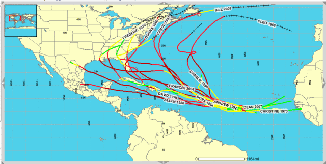
Looks fairly similar to the other graphic. It appears to be weighted more towards landfall than recurve when moving through 11.0N, 36.3W at this time of year. Only two of the storms on the list make a true recurve, while the rest go on to impact land at some point along their journey.
Last edited by Extremeweatherguy on Sun Aug 01, 2010 7:09 pm, edited 3 times in total.
0 likes
-
Ivanhater

- Storm2k Moderator

- Posts: 11222
- Age: 39
- Joined: Fri Jul 01, 2005 8:25 am
- Location: Pensacola
Re: ATL : INVEST 91L - DISCUSSION
I think the eastern wave is swinging to its north and the center will develop further north. That may be why some of the models are swinging further north
0 likes
Michael
-
dolebot_Broward_NW
- Category 2

- Posts: 529
- Joined: Fri Sep 10, 2004 6:38 am
Re: ATL : INVEST 91L - DISCUSSION
This could end up being one of the storms that initiates a massive evac from southern Florida where people get stuck in traffic for hours and hours and run out of gas
Taccido,
Such a thing doesn't happen here. We are well weathered in the art of Hurricane and realize that the only people who need to evac are those on the coast and in trailers. Since most of the trailers have been destroyed in past hurricanes, or the land sold out from under them - there are very few of them left.
Our homes are strong, our wills are iron, and our beaches are mostly oil-free.
Seriously: http://www.fema.gov/news/newsrelease.fema?id=8389 The last big evac was Floyd and thats what started the idea of "inland evac".
When a big storm threatens, we just go inland to survive the surge.
0 likes

Re: ATL : INVEST 91L - DISCUSSION
I have been out all day and just jumped on and I am very impressed with the system. I was curious if the convection east of the low around 33 or 34 W was the old mid level circ from the nice wave that came off Africa. It almost looks like it has been racing to catch up with the low.
http://www.ssd.noaa.gov/goes/flt/t1/flash-rb.html
http://www.ssd.noaa.gov/goes/flt/t1/flash-rb.html
0 likes
Re: ATL : INVEST 91L - DISCUSSION
Ivanhater wrote:I think the eastern wave is swinging to its north and the center will develop further north. That may be why some of the models are swinging further north
Its an interesting idea, certainly one to keep an eye on. That being said I think the region with 91L near 11N and tucked nicely within the deep convection looks in a good position to strengthen further.
The thing is with IR its impossible to have any idea where any center is due to the large convective shield.
0 likes
Personal Forecast Disclaimer:
The posts in this forum are NOT official forecast and should not be used as such. They are just the opinion of the poster and may or may not be backed by sound meteorological data. They are NOT endorsed by any professional institution or storm2k.org. For official information, please refer to the NHC and NWS products
The posts in this forum are NOT official forecast and should not be used as such. They are just the opinion of the poster and may or may not be backed by sound meteorological data. They are NOT endorsed by any professional institution or storm2k.org. For official information, please refer to the NHC and NWS products
-
HURAKAN

- Professional-Met

- Posts: 46084
- Age: 39
- Joined: Thu May 20, 2004 4:34 pm
- Location: Key West, FL
- Contact:

It should be TD #4 tomorrow morning and likely, Colin, later in the day.
Personal Forecast Disclaimer:
The posts in this forum are NOT official forecast and should not be used as such. They are just the opinion of the poster and may or may not be backed by sound meteorological data. They are NOT endorsed by any professional institution or storm2k.org. For official information, please refer to the NHC and NWS products.
0 likes
-
brunota2003

- S2K Supporter

- Posts: 9476
- Age: 35
- Joined: Sat Jul 30, 2005 9:56 pm
- Location: Stanton, KY...formerly Havelock, NC
- Contact:
-
Miami Storm Tracker

- Category 4

- Posts: 916
- Age: 68
- Joined: Sun Jun 13, 2010 10:12 pm
- Location: Key Largo, Fla.
- Contact:
Re: ATL : INVEST 91L - DISCUSSION
blp wrote:I have been out all day and just jumped on and I am very impressed with the system. I was curious if the convection east of the low around 33 or 34 W was the old mid level circ from the nice wave that came off Africa. It almost looks like it has been racing to catch up with the low.
http://www.ssd.noaa.gov/goes/flt/t1/flash-rb.html
Evening Brian,
very potent system in the works, As in most cases a 50 / 50 shot at where it will go.
0 likes
Re:
You can definitely tell that the convection is not competing with the ITCZ energy anymore.
brunota2003 wrote:Just a couple of observations...the first is that I notice the deep convection is back (very similar to last night). The second is that tonight's convection looks a LOT more consolidated than it did last night, or even earlier today.
0 likes
Re: ATL : INVEST 91L - DISCUSSION
Yep, I see nothing to stop this from ramping up. As most have said today it should be easily classified tomorrow when the first visible comes up. I don't think the NHC will pull the trigger tonight being so far away.
Miami Storm Tracker wrote:blp wrote:I have been out all day and just jumped on and I am very impressed with the system. I was curious if the convection east of the low around 33 or 34 W was the old mid level circ from the nice wave that came off Africa. It almost looks like it has been racing to catch up with the low.
http://www.ssd.noaa.gov/goes/flt/t1/flash-rb.html
Evening Brian,
very potent system in the works, As in most cases a 50 / 50 shot at where it will go.
0 likes
Re:
brunota2003 wrote:Just a couple of observations...the first is that I notice the deep convection is back (very similar to last night). The second is that tonight's convection looks a LOT more consolidated than it did last night, or even earlier today.
I think thats the key point there, it does look a lot more consolidated then last night when it was clearly drawing lots of energy from the ITCZ, but that presentation looks so good now the NHC may not even bother to wait for the Vis imagery and upgrade it next time round.
0 likes
Personal Forecast Disclaimer:
The posts in this forum are NOT official forecast and should not be used as such. They are just the opinion of the poster and may or may not be backed by sound meteorological data. They are NOT endorsed by any professional institution or storm2k.org. For official information, please refer to the NHC and NWS products
The posts in this forum are NOT official forecast and should not be used as such. They are just the opinion of the poster and may or may not be backed by sound meteorological data. They are NOT endorsed by any professional institution or storm2k.org. For official information, please refer to the NHC and NWS products
-
SFLcane

- S2K Supporter
- Posts: 10281
- Age: 48
- Joined: Sat Jun 05, 2010 1:44 pm
- Location: Lake Worth Florida
Re: ATL : INVEST 91L - DISCUSSION
If it ramps up pretty quickly i think recurve is probably inevitable.
0 likes
-
Miami Storm Tracker
- Category 4
- Posts: 916
- Age: 68
- Joined: Sun Jun 13, 2010 10:12 pm
- Location: Key Largo, Fla.
- Contact:
Might just be interesting to see how the track ends up evolving compared to what we saw with Bill, esp as both developed in a very similar location indeed, though as others have said in the model thread, we knew before it recurved what was going to happen.
0 likes
Personal Forecast Disclaimer:
The posts in this forum are NOT official forecast and should not be used as such. They are just the opinion of the poster and may or may not be backed by sound meteorological data. They are NOT endorsed by any professional institution or storm2k.org. For official information, please refer to the NHC and NWS products
The posts in this forum are NOT official forecast and should not be used as such. They are just the opinion of the poster and may or may not be backed by sound meteorological data. They are NOT endorsed by any professional institution or storm2k.org. For official information, please refer to the NHC and NWS products
-
Hurricane Andrew

- S2K Supporter
- Posts: 1891
- Age: 27
- Joined: Sun May 23, 2010 2:53 pm
- Location: KS
Re:
Miami Storm Tracker wrote:So what camp are you siding with, the recurve or the more west to wnw direction. I know it's way out but if it does get pulled north but misses the trough it just might do like a storm we know from 1992.
RIght now, I don't know. I have not anilized the models and stuff yet.
0 likes
The Enthusiast
NREMT-AEMT, WX nerd
Irene '11, Sandy '12, Irma '17 (SAR)
"Hard to think we were born to live this way..." -Wage War
-
Ivanhater
- Storm2k Moderator
- Posts: 11222
- Age: 39
- Joined: Fri Jul 01, 2005 8:25 am
- Location: Pensacola
Re: ATL : INVEST 91L - DISCUSSION
ASCAT...looks like the center is in between the 2 blobs that are merging around 11.5N 35.5w

0 likes
Michael

Re: ATL : INVEST 91L - DISCUSSION
I dunno about all this rapidly developing stuff - I know its hard to tell on IR but there is some sort of turning west of the main blow up of convection near 10.5N-38.5W which would put the main convection east of the center if indeed that is the LLC. If not, then we have a MLC separated from a developing LLC, not a good sign for quick development.
http://www.ssd.noaa.gov/goes/east/catl/loop-avn.html
http://www.ssd.noaa.gov/goes/east/catl/loop-avn.html
Last edited by ronjon on Sun Aug 01, 2010 7:32 pm, edited 1 time in total.
0 likes
Re: ATL : INVEST 91L - DISCUSSION
Couple of hours ago. I think Ivan you might be correct on something between the two blobs.

0 likes
Who is online
Users browsing this forum: No registered users and 50 guests