ATL: Ex COLIN - Models

Moderator: S2k Moderators

Message
Author
sjmballer
Tropical Low
Tropical Low
Posts: 13
Joined: Sun Sep 07, 2008 6:48 pm

Re: ATL: INVEST 91L - MODELS

#321 Postby sjmballer » Sun Aug 01, 2010 6:10 pm

redfish1 wrote:if i remember right didnt all the IKE models show him being a fish also??

you are right IKE was suppose to get picked up and follow HANNAH
0 likes   

CYCLONE MIKE
Category 5
Category 5
Posts: 2183
Joined: Tue Aug 31, 2004 6:04 pm
Location: Gonzales, LA

Re: ATL: INVEST 91L - MODELS

#322 Postby CYCLONE MIKE » Sun Aug 01, 2010 6:13 pm

Extremeweatherguy wrote:
redfish1 wrote:if i remember right didnt all the IKE models show him being a fish also??


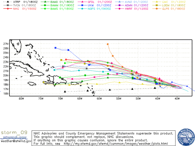
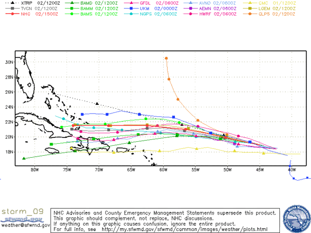
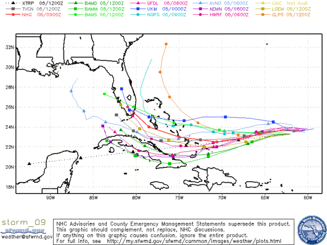
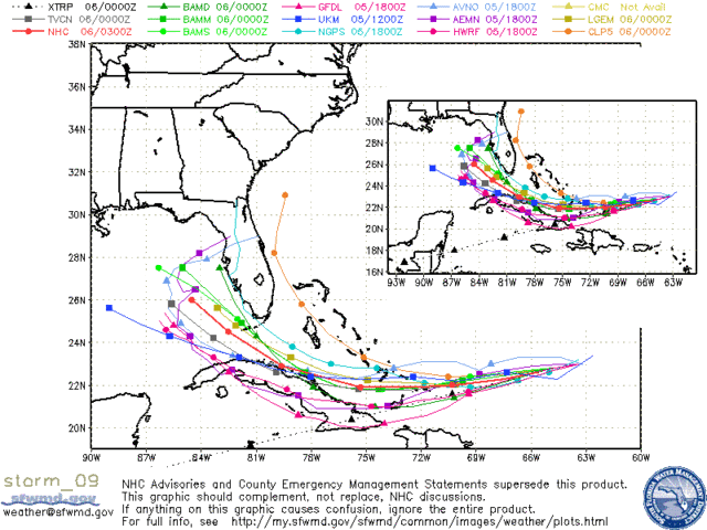
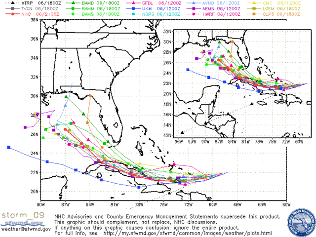
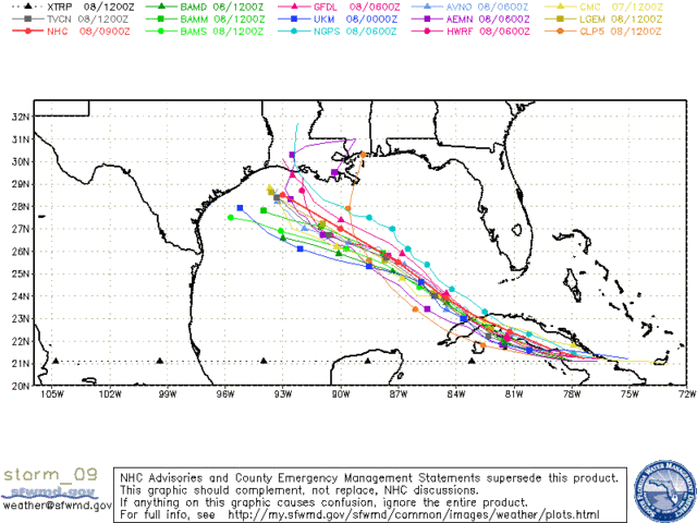
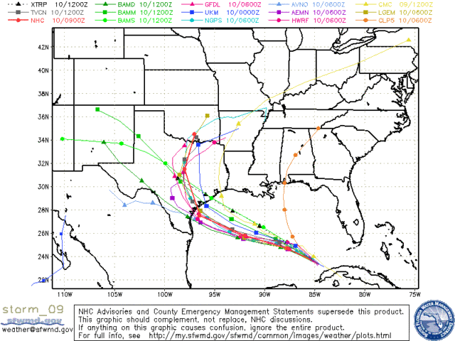
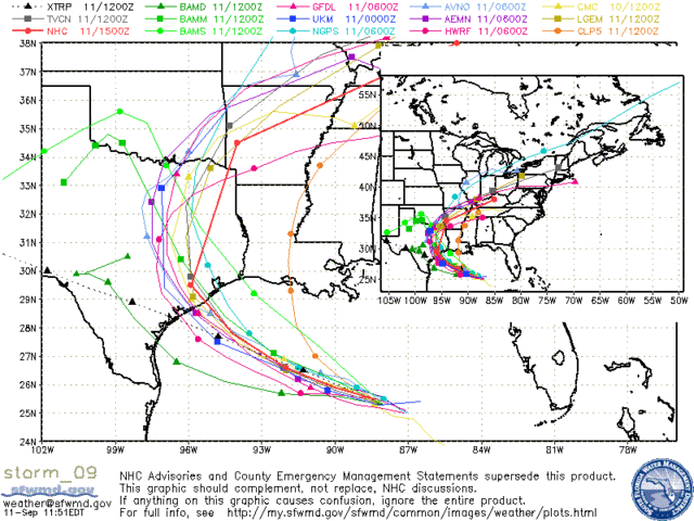
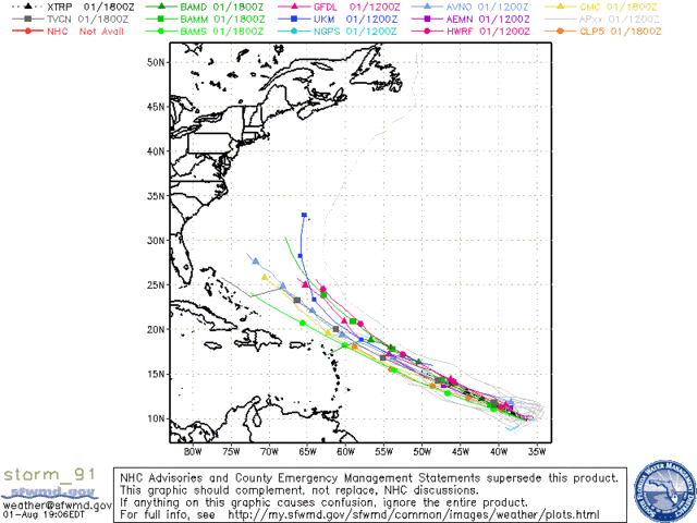
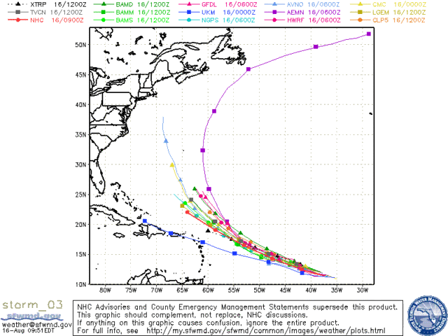
Here are a few saved images I have from Hurricane Ike showing model plots from various points of the storm's life:

http://i43.photobucket.com/albums/e371/ ... orm_09.gif
http://i43.photobucket.com/albums/e371/ ... m_09_3.gif
http://i43.photobucket.com/albums/e371/ ... m_09_5.gif
http://i43.photobucket.com/albums/e371/ ... m_09_6.gif
http://i43.photobucket.com/albums/e371/ ... m_09_7.gif
http://i43.photobucket.com/albums/e371/ ... m_09_9.gif
http://i43.photobucket.com/albums/e371/ ... _09_13.gif
http://i43.photobucket.com/albums/e371/ ... _09_18.gif
http://i43.photobucket.com/albums/e371/ ... _09_22.gif

At no time did it really look like IKE would be a "fish" (except for a few stray individual model runs), but it did look like the storm might try and turn northward well to the east of where it actually did (into FL instead of TX).


Never showed it being a true fish, but did keep showing a curve to the north at the end of every run all the time he just kept tracking west. Guess they eventually got it right though. :lol:
0 likes   

User avatar
AJC3
Admin
Admin
Posts: 3999
Age: 61
Joined: Tue Aug 31, 2004 7:04 pm
Location: Ballston Spa, New York
Contact:

Re: ATL: INVEST 91L - MODELS

#323 Postby AJC3 » Sun Aug 01, 2010 6:13 pm

sjmballer wrote:
redfish1 wrote:if i remember right didnt all the IKE models show him being a fish also??

you are right IKE was suppose to get picked up and follow HANNAH


As has already been pointed out...this is COMPLETELY untrue.

http://www.nhc.noaa.gov/archive/2008/gr ... p_5W.shtml
0 likes   

User avatar
Ivanhater
Storm2k Moderator
Storm2k Moderator
Posts: 11161
Age: 38
Joined: Fri Jul 01, 2005 8:25 am
Location: Pensacola

Re: ATL: INVEST 91L - MODELS

#324 Postby Ivanhater » Sun Aug 01, 2010 6:17 pm

18z HWRF

Image
0 likes   
Michael

User avatar
ronjon
Category 5
Category 5
Posts: 4822
Joined: Fri Aug 19, 2005 5:17 pm
Location: Hernando Beach, FL

Re: ATL: INVEST 91L - MODELS

#325 Postby ronjon » Sun Aug 01, 2010 6:18 pm

The GFS may be exhibiting its bias of deepening troughs too much but we'll see over the next few days with the mid-level steering. So far this year, the southern US 500 mb ridge has held strong and built back longer than the GFS wants to show with the European model having a much better grasp on the strength of upper level ridging. This may turn out to be a classic GFS vs Euro showdown again. Or the GFS is on to a major pattern change. Or out to lunch.
0 likes   

User avatar
KWT
Category 5
Category 5
Posts: 31415
Joined: Tue Aug 17, 2004 11:02 am
Location: UK!!!

#326 Postby KWT » Sun Aug 01, 2010 6:18 pm

I wonder what that same animation would look like with Dean...

Anyway the models are in fair agreement not on a recurve, the ECM doesn't but that not because it shows different synoptics, indeed its very close to 18z indeed, but because its just very weak with this system.
0 likes   
Personal Forecast Disclaimer:
The posts in this forum are NOT official forecast and should not be used as such. They are just the opinion of the poster and may or may not be backed by sound meteorological data. They are NOT endorsed by any professional institution or storm2k.org. For official information, please refer to the NHC and NWS products

User avatar
SFLcane
S2K Supporter
S2K Supporter
Posts: 10163
Age: 47
Joined: Sat Jun 05, 2010 1:44 pm
Location: Lake Worth Florida

Re:

#327 Postby SFLcane » Sun Aug 01, 2010 6:21 pm

KWT wrote:I wonder what that same animation would look like with Dean...

Anyway the models are in fair agreement not on a recurve, the ECM doesn't but that not because it shows different synoptics, indeed its very close to 18z indeed, but because its just very weak with this system.


http://www.nhc.noaa.gov/archive/2007/DEAN_graphics.shtml
0 likes   

User avatar
KWT
Category 5
Category 5
Posts: 31415
Joined: Tue Aug 17, 2004 11:02 am
Location: UK!!!

Re: ATL: INVEST 91L - MODELS

#328 Postby KWT » Sun Aug 01, 2010 6:21 pm

ronjon wrote:The GFS may be exhibiting its bias of deepening troughs too much but we'll see over the next few days with the mid-level steering. So far this year, the southern US 500 mb ridge has held strong and built back longer than the GFS wants to show with the European model having a much better grasp on the strength of upper level ridging. This may turn out to be a classic GFS vs Euro showdown again. Or the GFS is on to a major pattern change. Or out to lunch.


Interesting point, but my feeling is the fact the UKMO is also on the right hand side is very telling, its usually the one that overdoes ridging, plus the ECM really is as I said very close synoptically to the GFS, just alot weaker in terms of strength.

Ivanhater, look how strong it starts this system off at, no wonder the model jumps NNW pretty much from the get-go...looks a good deal too far east to me!
0 likes   
Personal Forecast Disclaimer:
The posts in this forum are NOT official forecast and should not be used as such. They are just the opinion of the poster and may or may not be backed by sound meteorological data. They are NOT endorsed by any professional institution or storm2k.org. For official information, please refer to the NHC and NWS products

User avatar
ronjon
Category 5
Category 5
Posts: 4822
Joined: Fri Aug 19, 2005 5:17 pm
Location: Hernando Beach, FL

Re:

#329 Postby ronjon » Sun Aug 01, 2010 6:22 pm

KWT wrote:I wonder what that same animation would look like with Dean...

Anyway the models are in fair agreement not on a recurve, the ECM doesn't but that not because it shows different synoptics, indeed its very close to 18z indeed, but because its just very weak with this system.


Have to disagreed with you on that one KWT - I don't think the Euro diggs the trough nearly is far south as the GFS nor lingers it as long as the GFS.
0 likes   

User avatar
cheezyWXguy
Category 5
Category 5
Posts: 6108
Joined: Mon Feb 13, 2006 12:29 am
Location: Dallas, TX

Re: ATL: INVEST 91L - MODELS

#330 Postby cheezyWXguy » Sun Aug 01, 2010 6:22 pm


once again, way too much initial northward motion, likely because it develops this thing way too fast. These models are programmed to assume this is already a tropical cyclone, right? If so, that would explain it...

EDIT: Another note, it looks like it starts it out alright, but then magically displaces it back to the northeast. Is this another vorticity center or is it an error...can someone explain this to me?
Last edited by cheezyWXguy on Sun Aug 01, 2010 6:25 pm, edited 1 time in total.
0 likes   

User avatar
Ivanhater
Storm2k Moderator
Storm2k Moderator
Posts: 11161
Age: 38
Joined: Fri Jul 01, 2005 8:25 am
Location: Pensacola

Re: ATL: INVEST 91L - MODELS

#331 Postby Ivanhater » Sun Aug 01, 2010 6:24 pm

Yep..HWRF and GFDL are far more reliable when a storm has developed..
0 likes   
Michael

User avatar
Extremeweatherguy
Category 5
Category 5
Posts: 11095
Joined: Mon Oct 10, 2005 8:13 pm
Location: Florida

#332 Postby Extremeweatherguy » Sun Aug 01, 2010 6:25 pm

For those comparing 91L to last year's Bill, here is a quick look at the model plots of both systems while they were in the same general starting vicinity..

91L: http://i43.photobucket.com/albums/e371/ ... orm_91.gif

Bill: http://i43.photobucket.com/albums/e371/ ... orm_03.gif

The future track of 91L appears much hazier than with Bill, IMO. While located in the same general location as 91L is currently, Bill was clearly much more of a re-curve candidate.
0 likes   

User avatar
Macrocane
Category 5
Category 5
Posts: 4218
Age: 36
Joined: Sun May 24, 2009 5:35 pm
Location: El Salvador

Re: ATL: INVEST 91L - MODELS

#333 Postby Macrocane » Sun Aug 01, 2010 6:29 pm

If it ends up being a fish I think that we will have to give merit to the Canadian.
0 likes   

User avatar
KWT
Category 5
Category 5
Posts: 31415
Joined: Tue Aug 17, 2004 11:02 am
Location: UK!!!

Re: Re:

#334 Postby KWT » Sun Aug 01, 2010 6:29 pm

ronjon wrote:
Have to disagreed with you on that one KWT - I don't think the Euro diggs the trough nearly is far south as the GFS nor lingers it as long as the GFS.


Yeah thats fair enough, the thing that makes me a little more comfortable with the GFS solution is the fact the UKMO model does what it does...notice on the Bill track how it was left of the rest of the models, the UKMO usually handles upper highs great but isn't nearly as good with upper troughs, so whilst it maybe too agressive, the fact it doesn't get that far west with the upper high gives some credit...

Then again the 12z UKMO moves at 30mph tomorrow...so yeah... :roll:
0 likes   
Personal Forecast Disclaimer:
The posts in this forum are NOT official forecast and should not be used as such. They are just the opinion of the poster and may or may not be backed by sound meteorological data. They are NOT endorsed by any professional institution or storm2k.org. For official information, please refer to the NHC and NWS products

User avatar
ronjon
Category 5
Category 5
Posts: 4822
Joined: Fri Aug 19, 2005 5:17 pm
Location: Hernando Beach, FL

Re: Re:

#335 Postby ronjon » Sun Aug 01, 2010 6:35 pm

KWT wrote:
ronjon wrote:
Have to disagreed with you on that one KWT - I don't think the Euro diggs the trough nearly is far south as the GFS nor lingers it as long as the GFS.


Yeah thats fair enough, the thing that makes me a little more comfortable with the GFS solution is the fact the UKMO model does what it does...notice on the Bill track how it was left of the rest of the models, the UKMO usually handles upper highs great but isn't nearly as good with upper troughs, so whilst it maybe too agressive, the fact it doesn't get that far west with the upper high gives some credit...

Then again the 12z UKMO moves at 30mph tomorrow...so yeah... :roll:


Actually, KWT, I went back to the 00Z and the 12Z 500 mb charts for todays Euro and they are nearly exactly the same at 168 and 192 hours with the only difference the strength of 91L. I understand your point about the UKM but didn't that model have one of the poorest track records at the 5 day time frame. I'm starting to think 91L won't develop nearly as quickly as it looked maybe 12 hours ago since its so large. That may cause an adjustment down the road on the tracks.
0 likes   

User avatar
Blown Away
S2K Supporter
S2K Supporter
Posts: 10145
Joined: Wed May 26, 2004 6:17 am

Re: ATL: INVEST 91L - MODELS

#336 Postby Blown Away » Sun Aug 01, 2010 6:36 pm

Ivanhater wrote:Yep, gets picked up

156 HOUR LOCATION:
Image
288 HOUR LOCATION:
Image


Gonna take 6 days to go from the 156 hour location to the 288 hour location, ummm very unlikely IMO.
0 likes   
Hurricane Eye Experience: David 79, Irene 99, Frances 04, Jeanne 04, Wilma 05... EYE COMING MY WAY IN 2024…
Hurricane Brush Experience: Andrew 92, Erin 95, Floyd 99, Matthew 16, Irma 17, Ian 22, Nicole 22…

CYCLONE MIKE
Category 5
Category 5
Posts: 2183
Joined: Tue Aug 31, 2004 6:04 pm
Location: Gonzales, LA

Re: ATL: INVEST 91L - MODELS

#337 Postby CYCLONE MIKE » Sun Aug 01, 2010 6:39 pm

Then again the 12z UKMO moves at 30mph tomorrow...so yeah...

Besides thinking the models are overplaying the trough, the above statement statement by KWT is another huge player. Most models are showing 91L moving wnw almost immediately and then accelerating to 25 mph or so for a couple of days. don't think it will happen tomorrow or at all.
0 likes   

User avatar
AtlanticWind
S2K Supporter
S2K Supporter
Posts: 1888
Age: 66
Joined: Sun Aug 08, 2004 9:57 pm
Location: Plantation,Fla

Re: ATL: INVEST 91L - MODELS

#338 Postby AtlanticWind » Sun Aug 01, 2010 6:43 pm

If models could predict tracks 7 to 10 days out preparing for storms would be much easier, but storms rarely hit the center of a 5 day cone.
long range forecasts should be taken as a best Guess only.
0 likes   

User avatar
Ivanhater
Storm2k Moderator
Storm2k Moderator
Posts: 11161
Age: 38
Joined: Fri Jul 01, 2005 8:25 am
Location: Pensacola

Re: ATL: INVEST 91L - MODELS

#339 Postby Ivanhater » Sun Aug 01, 2010 6:48 pm

GFDL: FAIL

Image
0 likes   
Michael

User avatar
TwisterFanatic
Category 5
Category 5
Posts: 1041
Joined: Mon Jun 28, 2010 12:43 pm
Location: Sallisaw, Oklahoma

#340 Postby TwisterFanatic » Sun Aug 01, 2010 6:51 pm

LMAO :ggreen:
0 likes   
Personal Forecast Disclaimer:
The posts in this forum are NOT official forecast and should not be used as such. They are just the opinion of the poster and may or may not be backed by sound meteorological data. They are NOT endorsed by any professional institution or storm2k.org. For official information, please refer to the NHC and NWS products.


Return to “2010”

Who is online

Users browsing this forum: No registered users and 1 guest