
ATL: Ex COLIN - Models
Moderator: S2k Moderators
-
SFLcane

- S2K Supporter

- Posts: 10281
- Age: 48
- Joined: Sat Jun 05, 2010 1:44 pm
- Location: Lake Worth Florida
Re: ATL: INVEST 91L - MODELS
The only reason the ECM takes this on a more southerly route is because it keeps it fairly weak.
0 likes
-
TwisterFanatic

- Category 5

- Posts: 1041
- Joined: Mon Jun 28, 2010 12:43 pm
- Location: Sallisaw, Oklahoma
Re: ATL: INVEST 91L - MODELS
SFLcane wrote:The only reason the ECM takes this on a more southerly route is because it keeps it fairly weak.
Last night wasn't it showing a strong hurricane on the southern route?
0 likes
Personal Forecast Disclaimer:
The posts in this forum are NOT official forecast and should not be used as such. They are just the opinion of the poster and may or may not be backed by sound meteorological data. They are NOT endorsed by any professional institution or storm2k.org. For official information, please refer to the NHC and NWS products.
The posts in this forum are NOT official forecast and should not be used as such. They are just the opinion of the poster and may or may not be backed by sound meteorological data. They are NOT endorsed by any professional institution or storm2k.org. For official information, please refer to the NHC and NWS products.
-
gatorcane

- S2K Supporter
- Posts: 23708
- Age: 48
- Joined: Sun Mar 13, 2005 3:54 pm
- Location: Boca Raton, FL
Re:
Dean4Storms wrote:At 180 that ridge is moving back to the west, notice the cyclone to its SE?
In this run, 91L/Colin goes fishing...and the systems behind it may go fishing as well perhaps in this run...
Now we just need to see the ECMWF show a Colin going fishing and I'd say we have some consensus! Though we had consensus between the GFS and ECMWF last night on a westrunner but looks like that consensus is gone now.
0 likes

This run shows though how close it could be, if for example 91L is down near 20N at 120hrs, then the risk to the EC goes up in a big way, really quite a tight situation, the upper trough is large but its not really that deep digging past say 96-144hrs, if the deed isn't done it'll probably slow right down as we on this 18z run.
The fact the upper trough doesn't do it first time is very interesting, I remember the models doing the same thing with Frances in 2004...
The fact the upper trough doesn't do it first time is very interesting, I remember the models doing the same thing with Frances in 2004...
0 likes
Personal Forecast Disclaimer:
The posts in this forum are NOT official forecast and should not be used as such. They are just the opinion of the poster and may or may not be backed by sound meteorological data. They are NOT endorsed by any professional institution or storm2k.org. For official information, please refer to the NHC and NWS products
The posts in this forum are NOT official forecast and should not be used as such. They are just the opinion of the poster and may or may not be backed by sound meteorological data. They are NOT endorsed by any professional institution or storm2k.org. For official information, please refer to the NHC and NWS products
-
CalmBeforeStorm

- Category 2

- Posts: 600
- Age: 72
- Joined: Tue Aug 10, 2004 7:55 pm
- Location: Stuart, Florida
Re: ATL: INVEST 91L - MODELS
Ivanhater wrote:Yep, gets picked up
On day eleven and after a close brush with the Carolinas. Hardly information to take to the bank.
0 likes
-
redfish1
- Tropical Storm

- Posts: 125
- Age: 45
- Joined: Thu Jun 17, 2010 9:24 pm
- Location: Port Arthur, Tx
Re: ATL: INVEST 91L - MODELS
if i remember right didnt all the IKE models show him being a fish also??
0 likes
-
Dean4Storms
- S2K Supporter
- Posts: 6358
- Age: 63
- Joined: Sun Aug 31, 2003 1:01 pm
- Location: Miramar Bch. FL
-
SFLcane
- S2K Supporter
- Posts: 10281
- Age: 48
- Joined: Sat Jun 05, 2010 1:44 pm
- Location: Lake Worth Florida
Re: ATL: INVEST 91L - MODELS
TwisterFanatic wrote:SFLcane wrote:The only reason the ECM takes this on a more southerly route is because it keeps it fairly weak.
Last night wasn't it showing a strong hurricane on the southern route?
Yep thats correct BUT the synoptic set-up has changed in the models. You have to get all your marbles in the correct slot for an eastcoast hit to take shape.
0 likes
-
Ivanhater

- Storm2k Moderator

- Posts: 11222
- Age: 39
- Joined: Fri Jul 01, 2005 8:25 am
- Location: Pensacola
Re: ATL: INVEST 91L - MODELS
Well the trend for today is for a more amplified trough off the east coast, including the Euro...Interesting to see if the 00z models continue the trend or back off on the trough
0 likes
Michael
-
CalmBeforeStorm
- Category 2
- Posts: 600
- Age: 72
- Joined: Tue Aug 10, 2004 7:55 pm
- Location: Stuart, Florida
My guess is they may well hold that solution now Ivanhater, however clearly if this one doesn't pick up as much latitude between 96-120hrs then things really become intresting.
Those slack currents aloft once the first upper trough moves away certainly suggest things could get interesting if it doesn't quite get as much latitude as expected.
Those slack currents aloft once the first upper trough moves away certainly suggest things could get interesting if it doesn't quite get as much latitude as expected.
0 likes
Personal Forecast Disclaimer:
The posts in this forum are NOT official forecast and should not be used as such. They are just the opinion of the poster and may or may not be backed by sound meteorological data. They are NOT endorsed by any professional institution or storm2k.org. For official information, please refer to the NHC and NWS products
The posts in this forum are NOT official forecast and should not be used as such. They are just the opinion of the poster and may or may not be backed by sound meteorological data. They are NOT endorsed by any professional institution or storm2k.org. For official information, please refer to the NHC and NWS products
-
hurricaneCW
- Category 5
- Posts: 1799
- Joined: Wed Mar 03, 2010 6:20 am
- Location: Toms River, NJ
Re: ATL: INVEST 91L - MODELS
Looks like a close call, kind of like last season's Bill, but it's still all speculation at this point.
0 likes
-
CYCLONE MIKE
- Category 5
- Posts: 2183
- Joined: Tue Aug 31, 2004 6:04 pm
- Location: Gonzales, LA
Re: ATL: INVEST 91L - MODELS
Ivanhater wrote:Well the trend for today is for a more amplified trough off the east coast, including the Euro...Interesting to see if the 00z models continue the trend or back off on the trough
Don't think they will back off much on the 00z runs, might even be a little more progressive with a recurve scenario. Do think in a day or two the models will probably start coming into more typical early august summertime terms and show a weaker/ weakening trough that will not have near the effect they are currently showing.
0 likes
-
hurricaneCW
- Category 5
- Posts: 1799
- Joined: Wed Mar 03, 2010 6:20 am
- Location: Toms River, NJ
Re: ATL: INVEST 91L - MODELS
The huge upper low pattern across the Western Atlantic does seem highly unusual for early August, and I have a feeling the trough will be weaker than models show right now. For some reason, I don't think it's going to go out to sea. Don't forget, any TUTT induced weakening would send it more on a westerly course.
0 likes
-
StormClouds63
- Category 2
- Posts: 583
- Age: 62
- Joined: Tue May 13, 2008 11:56 am
- Location: Southwest Louisiana
Re:
gatorcane wrote::uarrow:
Maybe but could be the fish train setting up if that trough lingers around the Central Atlantic....
Colin and Danielle might both go fishing looking at that last model run. In 2006, that east coast "trough" turned several systems into the open Atlantic grave yard.
Let's see if the models are consistent with this "fishing" scenario. 1969, 1995, and 2005 all had their fair share of these tracks.
0 likes
Yeah it does seem pretty potent, though its really only the 120-168hrs that the upper trough is strong, after that as we see the troughs are only strong enough to stall the system out or drift it northwards...
So if its a good deal further west or south then the 18z suggests before 120hrs, then once again things get interesting.
ps, the 18z GFS really isn't that far off a classic La Nina track FWIW...
So if its a good deal further west or south then the 18z suggests before 120hrs, then once again things get interesting.
ps, the 18z GFS really isn't that far off a classic La Nina track FWIW...
0 likes
Personal Forecast Disclaimer:
The posts in this forum are NOT official forecast and should not be used as such. They are just the opinion of the poster and may or may not be backed by sound meteorological data. They are NOT endorsed by any professional institution or storm2k.org. For official information, please refer to the NHC and NWS products
The posts in this forum are NOT official forecast and should not be used as such. They are just the opinion of the poster and may or may not be backed by sound meteorological data. They are NOT endorsed by any professional institution or storm2k.org. For official information, please refer to the NHC and NWS products
-
AtlanticWind

- S2K Supporter
- Posts: 1898
- Age: 67
- Joined: Sun Aug 08, 2004 9:57 pm
- Location: Plantation,Fla
Re: ATL: INVEST 91L - MODELS
Too early to call for The US. I think it could be a close call for the Islands.
0 likes
-
Extremeweatherguy

- Category 5
- Posts: 11095
- Joined: Mon Oct 10, 2005 8:13 pm
- Location: Florida
Re: ATL: INVEST 91L - MODELS
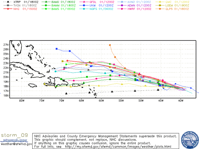
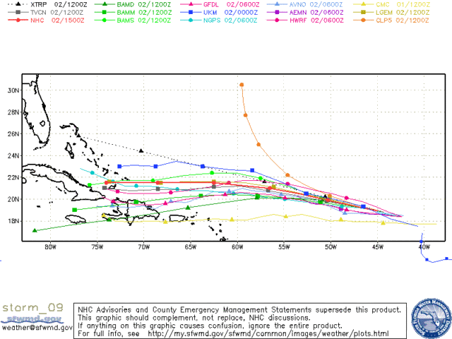
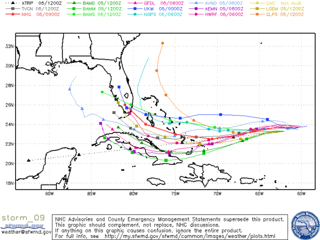
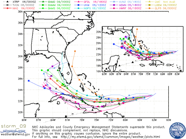
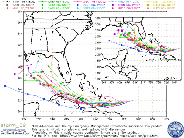
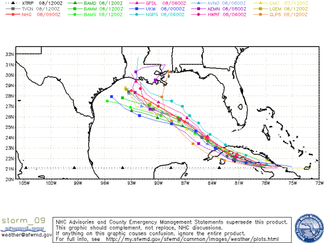
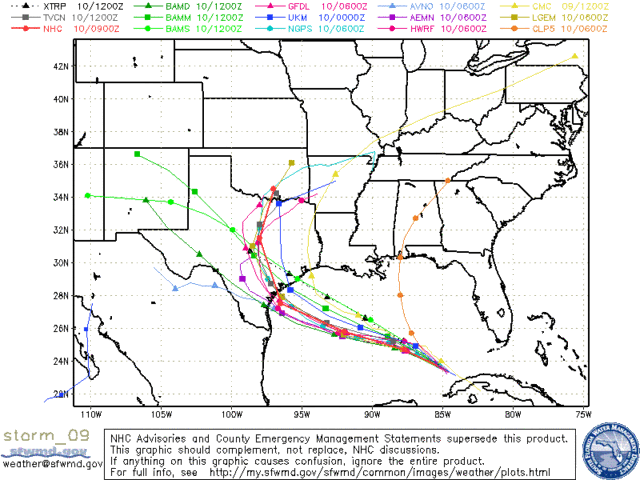
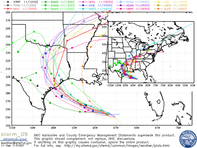
redfish1 wrote:if i remember right didnt all the IKE models show him being a fish also??
Here are a few saved images I have from Hurricane Ike showing model plots from various points of the storm's life:
http://i43.photobucket.com/albums/e371/ ... orm_09.gif
http://i43.photobucket.com/albums/e371/ ... m_09_3.gif
http://i43.photobucket.com/albums/e371/ ... m_09_5.gif
http://i43.photobucket.com/albums/e371/ ... m_09_6.gif
http://i43.photobucket.com/albums/e371/ ... m_09_7.gif
http://i43.photobucket.com/albums/e371/ ... m_09_9.gif
http://i43.photobucket.com/albums/e371/ ... _09_13.gif
http://i43.photobucket.com/albums/e371/ ... _09_18.gif
http://i43.photobucket.com/albums/e371/ ... _09_22.gif
At no time did it really look like IKE would be a "fish" (except for a few stray individual model runs), but it did look like the storm might try and turn northward well to the east of where it actually did (into FL instead of TX).
Last edited by Extremeweatherguy on Sun Aug 01, 2010 6:05 pm, edited 1 time in total.
0 likes
I do remember some models calling for Dean to be a fish though, I remember re-reading through it and quite a few people called for it to head into the NE Caribbean then either recurve or hit Florida...and that just kept on rolling westwards...
Not quite the same thing this year though, the 2007 High was an order above what we currently have, but I feel its going to be close enough to at least require serious watching.
Not quite the same thing this year though, the 2007 High was an order above what we currently have, but I feel its going to be close enough to at least require serious watching.
0 likes
Personal Forecast Disclaimer:
The posts in this forum are NOT official forecast and should not be used as such. They are just the opinion of the poster and may or may not be backed by sound meteorological data. They are NOT endorsed by any professional institution or storm2k.org. For official information, please refer to the NHC and NWS products
The posts in this forum are NOT official forecast and should not be used as such. They are just the opinion of the poster and may or may not be backed by sound meteorological data. They are NOT endorsed by any professional institution or storm2k.org. For official information, please refer to the NHC and NWS products
Who is online
Users browsing this forum: No registered users and 91 guests