ATL: TROPICAL DEPRESSION TWO - DISCUSSION
Moderator: S2k Moderators
-
Annie Oakley

- Category 5

- Posts: 1103
- Joined: Tue Jul 31, 2007 12:54 pm
- Location: Texas
-
HURAKAN

- Professional-Met

- Posts: 46084
- Age: 39
- Joined: Thu May 20, 2004 4:34 pm
- Location: Key West, FL
- Contact:
Re: ATL: INVEST 96L - DISCUSSION
07/2345 UTC 23.8N 93.6W T1.5/1.5 96L -- Atlantic
up from 1.0
up from 1.0
0 likes
-
ozonepete
- Professional-Met
- Posts: 4743
- Joined: Mon Sep 07, 2009 3:23 pm
- Location: From Ozone Park, NYC / Now in Brooklyn, NY
Re: ATL: INVEST 96L - DISCUSSION
AJC3 wrote:vbhoutex wrote: Please explain to me why there seems to be so much more convection over and near the Yucatan than near the "center" of a possibly organizing(not anymore imo)tropical system. Or am I reading this loop wrong? 96L has definitely perplexed me.
David, my guess would be either:
1) sea breeze thunderstorms, since we often see huge convective blowups over the Yucatan with or without a tropical disturbance nearby, or
2) enhanced convergence on the east side of the tropical disturbance creating a fairly stout convective band, or
3) some combination of 1 and 2.
YEs. That's fairly common to see when a tropical cyclone is to the west of the Yucatan. As the sea breeze thunderstorms converge over the mainland late in the day, they develop a thunderstorm cluster that can cover most of the Yucatan peninsula. The upper level NORTHWESTERLY flow from the outflow over the tropical cyclone adds divergence over the thunderstorm cluster that developed allowing it to become like a typical MCS (mesoscale Convective Complex). It usually gets elongated in the same direction as the anticyclonic outflow above the TS, if the TS has one.
Sorry! I fixed that big error. It's the northwesterly flow up at 250-200mb that causes divergence overhead if the cyclone is west of the Yucatan.
Last edited by ozonepete on Wed Jul 07, 2010 9:17 pm, edited 1 time in total.
0 likes


Re: ATL: INVEST 96L - DISCUSSION
HURAKAN wrote:07/2345 UTC 23.8N 93.6W T1.5/1.5 96L -- Atlantic
up from 1.0
That's just about where the plane found a center 23.7N 93.6W
0 likes
The following post is NOT an official forecast and should not be used as such. It is just the opinion of the poster and may or may not be backed by sound meteorological data. It is NOT endorsed by any professional institution including storm2k.org For Official Information please refer to the NHC and NWS products.

-
Annie Oakley
- Category 5
- Posts: 1103
- Joined: Tue Jul 31, 2007 12:54 pm
- Location: Texas
-
cycloneye

- Admin

- Posts: 149746
- Age: 69
- Joined: Thu Oct 10, 2002 10:54 am
- Location: San Juan, Puerto Rico
Re: ATL: INVEST 96L - DISCUSSION
Is tracking thru a cool pool of water caused by Alex.

0 likes
Visit the Caribbean-Central America Weather Thread where you can find at first post web cams,radars
and observations from Caribbean basin members Click Here
and observations from Caribbean basin members Click Here
-
Comanche

- Category 1

- Posts: 381
- Age: 54
- Joined: Wed Jul 06, 2005 9:33 am
- Location: Clear Lake City Texas
Re: ATL: INVEST 96L - DISCUSSION
OMG, are you guys lying to yourselves??? Seriously, look at an IR loop, hell look at any loop you want. This "thing" isn't even on life support anymore, no this is a case of not letting go, "keeping the corpse in the basement to collect the social security check".
Be honest with yourselves, this looks nothing less than AWFUL.
Truly, look at this loop- http://www.ssd.noaa.gov/goes/east/watl/flash-avn.html
Be honest with yourselves, this looks nothing less than AWFUL.
Truly, look at this loop- http://www.ssd.noaa.gov/goes/east/watl/flash-avn.html
0 likes
-
ozonepete
- Professional-Met
- Posts: 4743
- Joined: Mon Sep 07, 2009 3:23 pm
- Location: From Ozone Park, NYC / Now in Brooklyn, NY
Re: ATL: INVEST 96L - DISCUSSION
cycloneye wrote:Is tracking thru a cool pool of water caused by Alex.
Nice! We all forgot about that. Well, not all of us...
0 likes
-
wxman57

- Moderator-Pro Met

- Posts: 23175
- Age: 68
- Joined: Sat Jun 21, 2003 8:06 pm
- Location: Houston, TX (southwest)
Re: ATL: INVEST 96L - DISCUSSION
1 more hour of the loop added. Cloud tops still warming:
http://myweb.cableone.net/nolasue/gom.gif
http://myweb.cableone.net/nolasue/gom.gif
0 likes
-
ozonepete
- Professional-Met
- Posts: 4743
- Joined: Mon Sep 07, 2009 3:23 pm
- Location: From Ozone Park, NYC / Now in Brooklyn, NY
Re: ATL: INVEST 96L - DISCUSSION
Comanche wrote:OMG, are you guys lying to yourselves??? Seriously, look at an IR loop, hell look at any loop you want. This "thing" isn't even on life support anymore, no this is a case of not letting go, "keeping the corpse in the basement to collect the social security check".
Be honest with yourselves, this looks nothing less than AWFUL.
Truly, look at this loop- http://www.ssd.noaa.gov/goes/east/watl/flash-avn.html
It's not what you see on those loops that matters. It's what's going on in the atmosphere, and what will happen over the next 24 hours, that matters.
0 likes
-
wxman57
- Moderator-Pro Met
- Posts: 23175
- Age: 68
- Joined: Sat Jun 21, 2003 8:06 pm
- Location: Houston, TX (southwest)
Re: ATL: INVEST 96L - DISCUSSION
Organized convection is one criterion for upgrade. I don't think it could be argued that this disturbance has any organized convection.
0 likes
-
Comanche
- Category 1
- Posts: 381
- Age: 54
- Joined: Wed Jul 06, 2005 9:33 am
- Location: Clear Lake City Texas
Re: ATL: INVEST 96L - DISCUSSION
ozonepete wrote:Comanche wrote:OMG, are you guys lying to yourselves??? Seriously, look at an IR loop, hell look at any loop you want. This "thing" isn't even on life support anymore, no this is a case of not letting go, "keeping the corpse in the basement to collect the social security check".
Be honest with yourselves, this looks nothing less than AWFUL.
Truly, look at this loop- http://www.ssd.noaa.gov/goes/east/watl/flash-avn.html
It's not what you see on those loops that matters. It's what's going on in the atmosphere, and what will happen over the next 24 hours, that matters.
Like moving onshore???? That will be bullish for developement.
0 likes
-
cycloneye
- Admin
- Posts: 149746
- Age: 69
- Joined: Thu Oct 10, 2002 10:54 am
- Location: San Juan, Puerto Rico
Re: ATL: INVEST 96L - DISCUSSION
ozonepete wrote:cycloneye wrote:Is tracking thru a cool pool of water caused by Alex.
Nice! We all forgot about that. Well, not all of us...
Yes,I thought more members would be talking about this important factor.
0 likes
Visit the Caribbean-Central America Weather Thread where you can find at first post web cams,radars
and observations from Caribbean basin members Click Here
and observations from Caribbean basin members Click Here
-
Annie Oakley
- Category 5
- Posts: 1103
- Joined: Tue Jul 31, 2007 12:54 pm
- Location: Texas


Re: ATL: INVEST 96L - DISCUSSION
wxman57 wrote:Organized convection is one criterion for upgrade. I don't think it could be argued that this disturbance has any organized convection.
Seems like there has been convection circling around it since it left the Yucatan. Enough for a TD for sure.
0 likes
-
JonathanBelles
- Professional-Met
- Posts: 11430
- Age: 35
- Joined: Sat Dec 24, 2005 9:00 pm
- Location: School: Florida State University (Tallahassee, FL) Home: St. Petersburg, Florida
- Contact:
-
ozonepete
- Professional-Met
- Posts: 4743
- Joined: Mon Sep 07, 2009 3:23 pm
- Location: From Ozone Park, NYC / Now in Brooklyn, NY
Re: ATL: INVEST 96L - DISCUSSION
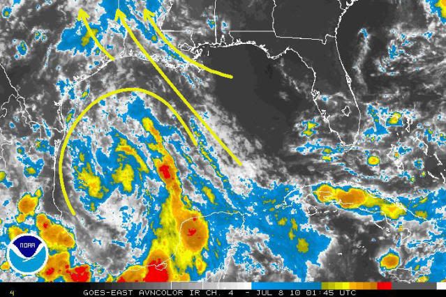
Look at this IR image. It reminds me of Alex, in that this system is beginning to get disconnected from the strong SE to NW flow around the western edge of the STR. Notice how its flow is becoming more circular and disengaged from the southeasterly flow it was embedded in for the last couple of days.
0 likes
-
cycloneye
- Admin
- Posts: 149746
- Age: 69
- Joined: Thu Oct 10, 2002 10:54 am
- Location: San Juan, Puerto Rico
Re: ATL: INVEST 96L - DISCUSSION
We have TD 2
invest_RENUMBER_al962010_al022010.ren
FSTDA
R
U
040
010
0000
201007080225
NONE
NOTIFY=ATRP
ftp://ftp.tpc.ncep.noaa.gov/atcf/tcweb/ ... 022010.ren
invest_RENUMBER_al962010_al022010.ren
FSTDA
R
U
040
010
0000
201007080225
NONE
NOTIFY=ATRP
ftp://ftp.tpc.ncep.noaa.gov/atcf/tcweb/ ... 022010.ren
0 likes
Visit the Caribbean-Central America Weather Thread where you can find at first post web cams,radars
and observations from Caribbean basin members Click Here
and observations from Caribbean basin members Click Here
Who is online
Users browsing this forum: No registered users and 79 guests