ATL: TROPICAL DEPRESSION ALEX - DISCUSSION
Moderator: S2k Moderators
-
ConvergenceZone
.gif)
- Category 5

- Posts: 5241
- Joined: Fri Jul 29, 2005 1:40 am
- Location: Northern California
-
HurricaneStriker
- Tropical Storm

- Posts: 195
- Joined: Fri Jun 25, 2010 7:23 pm
- Location: Austin, TX
-
MGC

- S2K Supporter

- Posts: 5941
- Joined: Sun Mar 23, 2003 9:05 pm
- Location: Pass Christian MS, or what is left.
Re: ATL: HURRICANE ALEX - DISCUSSION
Hard to believe that Alex is still a Cat-1. The hurricane has been bombing the last few hours. A eye has become visible and the CDO has a donut presentation. Radar eye is impressive despite the distance from the radar. Having a hard time beliving this is a 90mph Cat-1 hurricane......MGC
0 likes
-
Weatherfreak14

- Category 5
- Posts: 1381
- Joined: Sat Sep 24, 2005 3:40 pm
- Location: Beaufort, SC
- Contact:

-
HurricaneStriker
- Tropical Storm
- Posts: 195
- Joined: Fri Jun 25, 2010 7:23 pm
- Location: Austin, TX
6:00 advisory coming soon. 
EDIT: WOW!!!

EDIT:
Last edited by HurricaneStriker on Wed Jun 30, 2010 5:26 pm, edited 1 time in total.
0 likes
217 Miles from the Texas Shore


Re: ATL: HURRICANE ALEX - DISCUSSION
Forward motion seems to be slowing a bit, at least by looking at the Brownsville radar.
0 likes


Re: ATL: HURRICANE ALEX - DISCUSSION
Gulf Shot

--
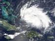
Northern Hemi Shot:
1- Alex is large
2- Big blob about to come off Africa


--
Northern Hemi Shot:
1- Alex is large
2- Big blob about to come off Africa

0 likes

If they don't find winds that justify category-2 in the NE quadrant or possibly even close in the NW qaudrant I'd be very surprised, presentation isn just about as good as your to get in a hurricane below major hurricane strength, I can't think of any category-2's that looked as good as this does to be honest of the top of my head...
0 likes
Personal Forecast Disclaimer:
The posts in this forum are NOT official forecast and should not be used as such. They are just the opinion of the poster and may or may not be backed by sound meteorological data. They are NOT endorsed by any professional institution or storm2k.org. For official information, please refer to the NHC and NWS products
The posts in this forum are NOT official forecast and should not be used as such. They are just the opinion of the poster and may or may not be backed by sound meteorological data. They are NOT endorsed by any professional institution or storm2k.org. For official information, please refer to the NHC and NWS products
-
HurricaneStriker
- Tropical Storm
- Posts: 195
- Joined: Fri Jun 25, 2010 7:23 pm
- Location: Austin, TX
-
HurricaneStriker
- Tropical Storm
- Posts: 195
- Joined: Fri Jun 25, 2010 7:23 pm
- Location: Austin, TX
-
Bocadude85

- Category 5
- Posts: 2991
- Age: 39
- Joined: Mon Apr 18, 2005 2:20 pm
- Location: Honolulu,Hi
Re:
KWT wrote:If they don't find winds that justify category-2 in the NE quadrant or possibly even close in the NW qaudrant I'd be very surprised, presentation isn just about as good as your to get in a hurricane below major hurricane strength, I can't think of any category-2's that looked as good as this does to be honest of the top of my head...
I agree.. Alex is looking great right now
0 likes

Re: Re:
ozonepete wrote:HurricaneStriker wrote:When I saw that pic, I couldn't believe this was still a Category 1.
It can't be a cat 1. There's no way. Just hope recon gets some good readings before it starts to weaken.
Wow!
It has been near Cat 2 for a few hours now, and it's probably at the Cat 1/2 border now. Whether it gains a few more kts to bump it up to Cat 2 is rather trivial, IMO, in the grand scheme of things. The difference in the damage potential between a 100 mph Cat 2 and a 95 mph Cat 1 isn't terribly significant. Sure, it's a pain since someone down the road might compare Alex to a 75 mph tiny hurricane, but that's why one should look at central pressure and max wind speed at land fall instead of just SS category.
Despite its appearance and low minimum central pressure, it's "only" a Cat 1 or weak Cat 2 right now largely because it has a huge wind field for a low-end hurricane. Heck, the hurricane force winds extend outward up to 70 miles from the center, and the tropical storm force winds extend up to 205 mi. That's a very large wind field for a strong Cat 1 or weak Cat 2. Such a large field of TS and Cat1 force winds requires that one have an anomalously low central pressure, otherwise you wouldn't be able to maintain the pressure gradient required for such a wind field. Wind speeds in such systems (well, at least in the mesoscale and larger) are proportional to the pressure gradient, or the change in pressure over some distance. So, if the distance is large (dr is big), and you maintain a TS/Cat1 strength pressure gradient (dp/dr), then the total change in pressure from the center to the background state (that is, dp) must be quite large.
0 likes
-
HurricaneStriker
- Tropical Storm
- Posts: 195
- Joined: Fri Jun 25, 2010 7:23 pm
- Location: Austin, TX
-
Bocadude85
- Category 5
- Posts: 2991
- Age: 39
- Joined: Mon Apr 18, 2005 2:20 pm
- Location: Honolulu,Hi
Looks like Alex is slowing down and taking a last minute wobble. Eye presentation also not looking as clear an as an hour ago on the radar and getting a little filled with weak precip.
Not surprising to hear of power cuts in SPI sadly.
Not surprising to hear of power cuts in SPI sadly.
0 likes
Personal Forecast Disclaimer:
The posts in this forum are NOT official forecast and should not be used as such. They are just the opinion of the poster and may or may not be backed by sound meteorological data. They are NOT endorsed by any professional institution or storm2k.org. For official information, please refer to the NHC and NWS products
The posts in this forum are NOT official forecast and should not be used as such. They are just the opinion of the poster and may or may not be backed by sound meteorological data. They are NOT endorsed by any professional institution or storm2k.org. For official information, please refer to the NHC and NWS products
-
lrak

- S2K Supporter
- Posts: 1770
- Age: 59
- Joined: Thu Jun 21, 2007 2:48 pm
- Location: Corpus Christi, TX
Re: ATL: HURRICANE ALEX - DISCUSSION
http://forecast.weather.gov/MapClick.ph ... tType=text
This is about my location, its rained all day and breezy.
This is about my location, its rained all day and breezy.
0 likes
AKA karl
Also
Personal Forecast Disclaimer:
My posts on this forum are NOT official forecast and should not be used as such. My posts are my basic observations and are definitely not backed by any "well some" meteorological knowledge. For official information, please refer to the NHC and NWS products.
Also
Personal Forecast Disclaimer:
My posts on this forum are NOT official forecast and should not be used as such. My posts are my basic observations and are definitely not backed by any "well some" meteorological knowledge. For official information, please refer to the NHC and NWS products.
-
HurricaneStriker
- Tropical Storm
- Posts: 195
- Joined: Fri Jun 25, 2010 7:23 pm
- Location: Austin, TX
98kts from recon in I believe the NW eyewall...to be honest thats high enough probably for the NHC to upgrade given it wouldn't take much for there to be another 5-6kts in the NE eyewall...and the pressure is super low now at 952mbs, sure is after Audrey isn't it.
Does look like its slowed down somewhat again. Eye really is looking a little rain filled now.
Does look like its slowed down somewhat again. Eye really is looking a little rain filled now.
0 likes
Personal Forecast Disclaimer:
The posts in this forum are NOT official forecast and should not be used as such. They are just the opinion of the poster and may or may not be backed by sound meteorological data. They are NOT endorsed by any professional institution or storm2k.org. For official information, please refer to the NHC and NWS products
The posts in this forum are NOT official forecast and should not be used as such. They are just the opinion of the poster and may or may not be backed by sound meteorological data. They are NOT endorsed by any professional institution or storm2k.org. For official information, please refer to the NHC and NWS products
Who is online
Users browsing this forum: No registered users and 49 guests