ATL: TROPICAL DEPRESSION ALEX - DISCUSSION
Moderator: S2k Moderators
-
Evil Jeremy

- S2K Supporter

- Posts: 5463
- Age: 32
- Joined: Mon Apr 10, 2006 2:10 pm
- Location: Los Angeles, CA
Re: Re:
KWT wrote:The next set from recon will show us whether we have a category-2 or not.
If you were talking about the set issued while or a minute after you were typing your post, no, we do not have a Cat 2 on our hands as of now.
Last edited by Evil Jeremy on Wed Jun 30, 2010 3:13 pm, edited 1 time in total.
0 likes
Frances 04 / Jeanne 04 / Katrina 05 / Wilma 05 / Fay 08 / Debby 12 / Andrea 13 / Colin 16 / Hermine 16 / Matthew 16 / Irma 17


-
cycloneye

- Admin

- Posts: 149736
- Age: 69
- Joined: Thu Oct 10, 2002 10:54 am
- Location: San Juan, Puerto Rico
Re: ATL: HURRICANE ALEX - DISCUSSION
Kudos to NHC for their track forecast and intensity one.
0 likes
Visit the Caribbean-Central America Weather Thread where you can find at first post web cams,radars
and observations from Caribbean basin members Click Here
and observations from Caribbean basin members Click Here
-
ConvergenceZone
.gif)
- Category 5

- Posts: 5241
- Joined: Fri Jul 29, 2005 1:40 am
- Location: Northern California
Re: ATL: HURRICANE ALEX - DISCUSSION
Since it's going to be landfalling in about 2 hours, if the next advisory doesn't show a cat 2, then it's probably as strong as it's going to get before landfall and will probably landfall as a cat 1
0 likes

Re: Re:
Evil Jeremy wrote:
If you were talking about the set issued while or a minute after you were typing your post, no, we do not have a Cat 2 on our hands as of now.
Indeed, winds found at 80kts at the surface which means no category-2 for Alex...but really at 80kts the impact will be similar to a category-2 anyway directly in the eyewall...
Going to be a tough call as to whether the band with hurricane force gusts will get into the Rio Grande region or stay just to the south, going to be a very close call!
0 likes
Personal Forecast Disclaimer:
The posts in this forum are NOT official forecast and should not be used as such. They are just the opinion of the poster and may or may not be backed by sound meteorological data. They are NOT endorsed by any professional institution or storm2k.org. For official information, please refer to the NHC and NWS products
The posts in this forum are NOT official forecast and should not be used as such. They are just the opinion of the poster and may or may not be backed by sound meteorological data. They are NOT endorsed by any professional institution or storm2k.org. For official information, please refer to the NHC and NWS products
-
HurricaneStriker
- Tropical Storm

- Posts: 195
- Joined: Fri Jun 25, 2010 7:23 pm
- Location: Austin, TX

Re: ATL: HURRICANE ALEX - DISCUSSION
TheBurn wrote:
Hard to believe a storm with pressure in the 960's and that type of IR appearance doesn't have cat-2 winds in there somewhere.
0 likes

-
HURAKAN

- Professional-Met

- Posts: 46084
- Age: 39
- Joined: Thu May 20, 2004 4:34 pm
- Location: Key West, FL
- Contact:
144
URNT12 KNHC 302013
VORTEX DATA MESSAGE AL012010
A. 30/19:54:00Z
B. 24 deg 24 min N
096 deg 42 min W
C. 850 mb 1090 m
D. 60 kt
E. 223 deg 10 nm
F. 330 deg 69 kt
G. 236 deg 51 nm
H. 959 mb
I. 15 C / 1523 m
J. 22 C / 1525 m
K. 20 C / NA
L. CLOSED
M. C12
N. 12345 / 8
O. 0.02 / 2 nm
P. AF304 1201A ALEX OB 14
MAX FL WIND 90 KT NE QUAD 19:59:00Z
MAX OUTBOUND FL WIND 90 KT NE QUAD 19:59:00Z
;
0 likes


-
HurricaneStriker
- Tropical Storm
- Posts: 195
- Joined: Fri Jun 25, 2010 7:23 pm
- Location: Austin, TX
Re:
HURAKAN wrote:
Latest radar loop
Seems like the eye's getting filled in with precipitation.
0 likes
217 Miles from the Texas Shore
That is what happens bahamaswx when the storm doesn't put all of its 'energy' into one eyewall and instead spread out between two wind Maxima's like Alex has.
Plenty of strong cells pushing into S.Texas, must be getting close to 12 inches of rain in the last 12hrs down there...W.eyewall not that far off from landfall now.
Plenty of strong cells pushing into S.Texas, must be getting close to 12 inches of rain in the last 12hrs down there...W.eyewall not that far off from landfall now.
0 likes
Personal Forecast Disclaimer:
The posts in this forum are NOT official forecast and should not be used as such. They are just the opinion of the poster and may or may not be backed by sound meteorological data. They are NOT endorsed by any professional institution or storm2k.org. For official information, please refer to the NHC and NWS products
The posts in this forum are NOT official forecast and should not be used as such. They are just the opinion of the poster and may or may not be backed by sound meteorological data. They are NOT endorsed by any professional institution or storm2k.org. For official information, please refer to the NHC and NWS products
Re: ATL: HURRICANE ALEX - DISCUSSION
We've got mammatus clouds compliments of Alex....sign of instability....HELLO ALEX!!!
0 likes
-
HurricaneStriker
- Tropical Storm
- Posts: 195
- Joined: Fri Jun 25, 2010 7:23 pm
- Location: Austin, TX


-
HurricaneStriker
- Tropical Storm
- Posts: 195
- Joined: Fri Jun 25, 2010 7:23 pm
- Location: Austin, TX
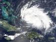
That IR presentation is pretty immense it has to be said!
Recon shows the system has moved more or less due west in the last hour or so.
Recon shows the system has moved more or less due west in the last hour or so.
0 likes
Personal Forecast Disclaimer:
The posts in this forum are NOT official forecast and should not be used as such. They are just the opinion of the poster and may or may not be backed by sound meteorological data. They are NOT endorsed by any professional institution or storm2k.org. For official information, please refer to the NHC and NWS products
The posts in this forum are NOT official forecast and should not be used as such. They are just the opinion of the poster and may or may not be backed by sound meteorological data. They are NOT endorsed by any professional institution or storm2k.org. For official information, please refer to the NHC and NWS products
-
HurricaneStriker
- Tropical Storm
- Posts: 195
- Joined: Fri Jun 25, 2010 7:23 pm
- Location: Austin, TX

Who is online
Users browsing this forum: No registered users and 56 guests