ATL: TROPICAL DEPRESSION ALEX - DISCUSSION

Moderator: S2k Moderators

Message
Author
User avatar
Chacor
Category 5
Category 5
Posts: 10229
Joined: Mon Oct 02, 2006 10:43 pm
Location: Singapore

Re:

#1181 Postby Chacor » Thu Jun 24, 2010 8:01 pm

KWT wrote:Will be good to finally see recon flying for the first time this season!


The Plan of the Day has called for recon three days in a row now. The last two days, it was cancelled.

And, sorry I'm plugging this here, for those who enjoy the sheer brilliance of hurricanes, have a look over at the EPac Hurricane Celia thread. It's nearly annular and almost a Cat 5.
0 likes   

Dean4Storms
S2K Supporter
S2K Supporter
Posts: 6358
Age: 62
Joined: Sun Aug 31, 2003 1:01 pm
Location: Miramar Bch. FL

#1182 Postby Dean4Storms » Thu Jun 24, 2010 8:04 pm

One thing for certain, there is a lot of moisture coming up with this system, I think everyone from Texas clear to FL Panhandle could see a good bit of rain from this especially if that trough sets up along the Gulf Coast.
0 likes   

User avatar
KWT
Category 5
Category 5
Posts: 31415
Joined: Tue Aug 17, 2004 11:02 am
Location: UK!!!

Re: Re:

#1183 Postby KWT » Thu Jun 24, 2010 8:06 pm

Chacor wrote:
KWT wrote:Will be good to finally see recon flying for the first time this season!


The Plan of the Day has called for recon three days in a row now. The last two days, it was cancelled.


True but this time I think we are at the point in the game where I think they will want to try and find a LLC, esp if the convection remains...
0 likes   
Personal Forecast Disclaimer:
The posts in this forum are NOT official forecast and should not be used as such. They are just the opinion of the poster and may or may not be backed by sound meteorological data. They are NOT endorsed by any professional institution or storm2k.org. For official information, please refer to the NHC and NWS products

User avatar
South Texas Storms
Professional-Met
Professional-Met
Posts: 4227
Joined: Thu Jun 24, 2010 12:28 am
Location: Houston, TX

Re: ATL: INVEST 93L - DISCUSSION

#1184 Postby South Texas Storms » Thu Jun 24, 2010 8:12 pm

does 93L remind yall of hurricane dolly a few years ago? it looks pretty similar to me.
0 likes   

Air Force Met
Military Met
Military Met
Posts: 4372
Age: 56
Joined: Tue Jul 08, 2003 9:30 am
Location: Roan Mountain, TN

Re: ATL: INVEST 93L - DISCUSSION

#1185 Postby Air Force Met » Thu Jun 24, 2010 8:14 pm

South Texas Storms wrote:does 93L remind yall of hurricane dolly a few years ago? it looks pretty similar to me.


A buddy of mine made a similar comment earlier. Hope it doesn't mean Igor is going to cream Galveston....
0 likes   

User avatar
Nimbus
Category 5
Category 5
Posts: 5303
Joined: Mon Jul 19, 2004 10:54 am

#1186 Postby Nimbus » Thu Jun 24, 2010 8:15 pm

Down at the low levels the circulation was elongated earlier in the day. This latest convective plume may focus the energy. It will be interesting to see the model runs once they get a clear LLC fix on this thing.
0 likes   

User avatar
Andrew92
S2K Supporter
S2K Supporter
Posts: 3247
Age: 41
Joined: Mon Jun 16, 2003 12:35 am
Location: Phoenix, Arizona

#1187 Postby Andrew92 » Thu Jun 24, 2010 8:17 pm

The following post is NOT official forecast and should not be used as such. It is just the opinion of the poster and may or may not be backed by sound meteorological data. It is NOT endorsed by any professional institution or storm2k.org. For official information, please refer to the NHC and NWS products.

I've been following this quietly as well, but this doesn't remind me of Dolly too much. For some reason, I'm actually reminded of Tropical Storm Bill from 2003 and Hurricane Cindy from 2005. The time of the year is similar, and I know a popular early forecast for Cindy took it into Texas as a minimal hurricane. Yet, both of them landfalled in the same general area, in eastern Louisiana, and even took similar paths getting there and beyond.

I dunno, it could easily end up in Mexico or Texas, but I get a vibe that this may be another Bill or Cindy. Time will tell though!

-Andrew92
0 likes   

User avatar
gatorcane
S2K Supporter
S2K Supporter
Posts: 23691
Age: 47
Joined: Sun Mar 13, 2005 3:54 pm
Location: Boca Raton, FL

#1188 Postby gatorcane » Thu Jun 24, 2010 8:25 pm

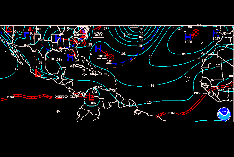
Latest TAFB graphic at 72 hours:. Ridge (jagged line) appears to be breaking down over Texas and WGOM:

Image
0 likes   

User avatar
thetruesms
Professional-Met
Professional-Met
Posts: 844
Age: 41
Joined: Thu Aug 16, 2007 1:14 pm
Location: Tallahasee, FL
Contact:

Re: Re:

#1189 Postby thetruesms » Thu Jun 24, 2010 8:46 pm

wxman57 wrote:Can't talk a lot about that, as I'm participating in conference calls with them. What I can say is that they're paying very close attention to this disturbance and I've told them that the earliest that they might see squalls which could shut down helicopter evacuation operations is on Tuesday. They won't stay on location if there is a significant threat of a TS/H heading their way. And it'll be a VERY big deal if they have to abandon the capturing of oil and the relief wells. Let's hope it heads to Mexico and/or it doesn't develop.

Air Force Met wrote:I can't really talk about it either...since I am in the loop on the DHS/NORTHCOM side of the house...but what :uarrow: said...
How many of us around here are involved with spill response? :lol: That's at least three, though I'm more of a backstop than consistently involved

KWT wrote:True but this time I think we are at the point in the game where I think they will want to try and find a LLC, esp if the convection remains...
Yeah, I'm fully expecting that the schedule for tomorrow will go through now that there's something to go looking for
0 likes   

User avatar
cycloneye
Admin
Admin
Posts: 145455
Age: 68
Joined: Thu Oct 10, 2002 10:54 am
Location: San Juan, Puerto Rico

Re: ATL: INVEST 93L - DISCUSSION

#1190 Postby cycloneye » Thu Jun 24, 2010 8:48 pm

Latest 850MB vorticity data has expanded. AFM,what does this tells you, relocation may be more NE?

Image
0 likes   
Visit the Caribbean-Central America Weather Thread where you can find at first post web cams,radars
and observations from Caribbean basin members Click Here

User avatar
gatorcane
S2K Supporter
S2K Supporter
Posts: 23691
Age: 47
Joined: Sun Mar 13, 2005 3:54 pm
Location: Boca Raton, FL

#1191 Postby gatorcane » Thu Jun 24, 2010 8:57 pm

What a nice upper anticyclone sitting over the Western Caribbean. The reason why you see the convection blowing off to the South right now is because it is still under the influence of some northerly shear on the east side of this upper high. But by this time tomorrow, should be right underneath the upper high where ideal conditions will be present:

Image
0 likes   

User avatar
canetracker
S2K Supporter
S2K Supporter
Posts: 751
Age: 62
Joined: Wed Jul 27, 2005 8:49 pm
Location: Suburbia New Orleans...Harahan, LA

Re:

#1192 Postby canetracker » Thu Jun 24, 2010 9:43 pm

Andrew92 wrote:The following post is NOT official forecast and should not be used as such. It is just the opinion of the poster and may or may not be backed by sound meteorological data. It is NOT endorsed by any professional institution or storm2k.org. For official information, please refer to the NHC and NWS products.

I've been following this quietly as well, but this doesn't remind me of Dolly too much. For some reason, I'm actually reminded of Tropical Storm Bill from 2003 and Hurricane Cindy from 2005. The time of the year is similar, and I know a popular early forecast for Cindy took it into Texas as a minimal hurricane. Yet, both of them landfalled in the same general area, in eastern Louisiana, and even took similar paths getting there and beyond.

I dunno, it could easily end up in Mexico or Texas, but I get a vibe that this may be another Bill or Cindy. Time will tell though!

-Andrew92

Me too and totally agree. I hope wherever it hits that it will do the least amount of oil spill damage to the coastlines.
0 likes   

User avatar
Kludge
S2K Supporter
S2K Supporter
Posts: 215
Joined: Thu Aug 26, 2004 9:03 pm
Location: Montgomery, Texas

Re: ATL: INVEST 93L - DISCUSSION

#1193 Postby Kludge » Thu Jun 24, 2010 10:01 pm

My non-professional observation would be:

In order to build into anything beyond the peak status of a minimal depression, this blob better hurry up and intensify quickly. Otherwise, the Yucatan will Yuca-tear it apart.

Without a quickening of forward speed, or an abrupt northward turn, or a stall in the campeche bathtub, the chances of building into a substantial storm before a final landfall seem unlikely.

If it were to slide across the Yucatan and somehow survive, then stall as a result of the "front"... over the jacuzzi gulf waters... then all bets are off. At that point, Alex would be able to take its time and do a thorough assessment, and then decide "whose ass to kick". :)
0 likes   

Time_Zone
Category 1
Category 1
Posts: 251
Joined: Sat May 08, 2010 4:15 am

Re: ATL: INVEST 93L - DISCUSSION

#1194 Postby Time_Zone » Thu Jun 24, 2010 10:18 pm

Kludge wrote:My non-professional observation would be:

In order to build into anything beyond the peak status of a minimal depression, this blob better hurry up and intensify quickly. Otherwise, the Yucatan will Yuca-tear it apart.

Without a quickening of forward speed, or an abrupt northward turn, or a stall in the campeche bathtub, the chances of building into a substantial storm before a final landfall seem unlikely.

If it were to slide across the Yucatan and somehow survive, then stall as a result of the "front"... over the jacuzzi gulf waters... then all bets are off. At that point, Alex would be able to take its time and do a thorough assessment, and then decide "whose ass to kick". :)


I wouldn't say it's likely to die if it clips the Yucatan.
0 likes   

User avatar
HURAKAN
Professional-Met
Professional-Met
Posts: 46086
Age: 38
Joined: Thu May 20, 2004 4:34 pm
Location: Key West, FL
Contact:

#1195 Postby HURAKAN » Thu Jun 24, 2010 10:25 pm

Image

00z
0 likes   

User avatar
Ivanhater
Storm2k Moderator
Storm2k Moderator
Posts: 11162
Age: 38
Joined: Fri Jul 01, 2005 8:25 am
Location: Pensacola

Re: ATL: INVEST 93L - DISCUSSION

#1196 Postby Ivanhater » Thu Jun 24, 2010 10:27 pm

ASCAT

Looks like we have a closed low

Image
0 likes   
Michael

User avatar
Macrocane
Category 5
Category 5
Posts: 4218
Age: 36
Joined: Sun May 24, 2009 5:35 pm
Location: El Salvador

Re: ATL: INVEST 93L - DISCUSSION

#1197 Postby Macrocane » Thu Jun 24, 2010 10:27 pm

:uarrow: I agree it will survive the Yucatan Peninsula, it will probably weaken but will survive unless it spends a lot of time inland. Some examples of systems that have survived Yucatan:

2005 Stan
2005 Wilma
2007 Dean
2008 Dolly
0 likes   

Sanibel
Category 5
Category 5
Posts: 10375
Joined: Mon Aug 30, 2004 11:06 pm
Location: Offshore SW Florida

Re: ATL: INVEST 93L - DISCUSSION

#1198 Postby Sanibel » Thu Jun 24, 2010 10:27 pm

Could be a center split with one nearer to the convection.


I think crash and burn on Honduras on this course...
0 likes   

User avatar
cycloneye
Admin
Admin
Posts: 145455
Age: 68
Joined: Thu Oct 10, 2002 10:54 am
Location: San Juan, Puerto Rico

Re: ATL: INVEST 93L - DISCUSSION

#1199 Postby cycloneye » Thu Jun 24, 2010 10:29 pm

Ivanhater wrote:ASCAT

Looks like we have a closed low

Image


Still kind of broad.
0 likes   
Visit the Caribbean-Central America Weather Thread where you can find at first post web cams,radars
and observations from Caribbean basin members Click Here

User avatar
CourierPR
Category 5
Category 5
Posts: 1335
Age: 71
Joined: Tue Aug 31, 2004 7:53 pm
Location: Pompano Beach, Florida

Re:

#1200 Postby CourierPR » Thu Jun 24, 2010 10:34 pm

gatorcane wrote:What a nice upper anticyclone sitting over the Western Caribbean. The reason why you see the convection blowing off to the South right now is because it is still under the influence of some northerly shear on the east side of this upper high. But by this time tomorrow, should be right underneath the upper high where ideal conditions will be present:

Image

What a difference a day makes. Yesterday, Gatorcane, you were telling us that this would not develop and that the models were lining up in agreement. Welcome aboard the bandwagon.
0 likes   


Return to “2010”

Who is online

Users browsing this forum: No registered users and 2 guests