EPAC : TROPICAL DEPRESSION CELIA - DISCUSSION
Moderator: S2k Moderators


-
Ad Novoxium
- Category 1

- Posts: 348
- Age: 35
- Joined: Sat May 03, 2008 2:12 am
Re: EPAC : HURRICANE CELIA - DISCUSSION
Just wondering, but how do Celia's annular traits match up with those of Epsilon 05 (specifically in the SST field)?
0 likes

Re: EPAC : HURRICANE CELIA - DISCUSSION
Celia has a very nice outflow, it has been a very interesting system. I think that it could be going annular it just needs to clear the big eye that the microwave picture showed and as Chacor said it needs to be in cooler waters.
0 likes
-
Dick Pache
- Tropical Storm

- Posts: 155
- Age: 85
- Joined: Wed Aug 24, 2005 7:00 pm
- Location: TGU Honduras 14.047N, 87.218W
Re: EPAC : HURRICANE CELIA - DISCUSSION
http://rammb.cira.colostate.edu/resourc ... _Knaff.pdf
ABSTRACT
This study introduces and examines a symmetric category of tropical cyclone, which the authors call annular
hurricanes. The structural characteristics and formation of this type of hurricane are examined and documented
using satellite and aircraft reconnaissance data. The formation is shown to be systematic, resulting from what
appears to be asymmetric mixing of eye and eyewall components of the storms involving either one or two
possible mesovortices. Flight-level thermodynamic data support this contention, displaying uniform values of
equivalent potential temperature in the eye, while the flight-level wind observations within annular hurricanes
show evidence that mixing inside the radius of maximum wind likely continues. Intensity tendencies of annular
hurricanes indicate that these storms maintain their intensities longer than the average hurricane, resulting in
larger-than-average intensity forecast errors and thus a significant intensity forecasting challenge. In addition,
these storms are found to exist in a specific set of environmental conditions, which are only found 3% and 0.8%
of the time in the east Pacific and Atlantic tropical cyclone basins during 1989–99, respectively. With forecasting
issues in mind, two methods of objectively identifying these storms are also developed and discussed
0 likes
Re: EPAC : HURRICANE CELIA - DISCUSSION
Ad Novoxium wrote:Just wondering, but how do Celia's annular traits match up with those of Epsilon 05 (specifically in the SST field)?
SSTs for Epsilon were (relatively) ice cold; 21.7° at the time of max intensity, some 7° C cooler than the waters Celia is over.
0 likes
Re: EPAC : HURRICANE CELIA - DISCUSSION
It's failing to meet another one of the annular hurricane screening criteria; not obvious to me which one (in addition to SSTs) it is.
Code: Select all
                    *   EAST PACIFIC SHIPS INTENSITY FORECAST   *
                    *      GOES DATA AVAILABLE                  *
                    *      OHC  DATA AVAILABLE                  *
                    *       CELIA  EP042010  06/24/10  18 UTC   *

TIME (HR)          0     6    12    18    24    36    48    60    72    84    96   108   120
V (KT) NO LAND   115   118   116   114   109    96    74    63    49    42    32    25    18
V (KT) LAND      115   118   116   114   109    96    74    63    49    42    32    25    18
V (KT) LGE mod   115   116   112   106   100    86    73    62    53    45    39    35    31

SHEAR (KT)         4     6     3     1    11     4     2     3     3     4     2     8     5
SHEAR ADJ (KT)     4     5     5     4     0     0     3     8     8     9     6     1     1
SHEAR DIR        267   287   204   119   127   121   206   158   360   115   135    95   114
SST (C)         28.8  28.5  28.2  27.7  27.0  25.6  24.9  24.8  24.8  24.7  24.4  24.3  24.5
POT. INT. (KT)   153   150   147   141   134   119   111   109   108   107   103   102   105
200 MB T (C)   -51.5 -51.0 -51.5 -51.4 -51.1 -51.5 -51.8 -51.1 -51.7 -51.5 -51.6 -51.6 -51.8
TH_E DEV (C)       5     4     4     3     3     2     1     1     1     2     2     2     2
700-500 MB RH     66    64    64    62    63    63    59    49    48    49    45    42    36
GFS VTEX (KT)     23    24    23    23    24    25    20    21    18    18    16    15    13
850 MB ENV VOR    34    30    27    13    13    18     9    15     8     7    12    20    22
200 MB DIV         7    17   -14   -34   -11   -26    -8    32   -42     0   -23    -5   -14
LAND (KM)       1227  1246  1278  1301  1334  1390  1431  1498  1563  1615  1629  1668  1735
LAT (DEG N)     12.6  12.9  13.2  13.6  14.0  14.8  15.5  15.9  16.1  16.3  16.6  16.6  16.3
LONG(DEG W)    114.2 115.4 116.5 117.5 118.5 120.3 121.8 123.1 124.1 124.9 125.3 125.8 126.4
STM SPEED (KT)    11    12    11    11    10     9     7     5     4     3     2     2     3
HEAT CONTENT      52    52    51    38    20     0     0     0     0     0     0     0     0

  FORECAST TRACK FROM OFCI      INITIAL HEADING/SPEED (DEG/KT):280/ 10      CX,CY:  -9/  2
  T-12 MAX WIND:  95            PRESSURE OF STEERING LEVEL (MB):  535  (MEAN=581)
  GOES IR BRIGHTNESS TEMP. STD DEV.  50-200 KM RAD:  12.7 (MEAN=14.5)
  % GOES IR PIXELS WITH T < -20 C    50-200 KM RAD:  88.0 (MEAN=65.0)

                        INDIVIDUAL CONTRIBUTIONS TO INTENSITY CHANGE
                         6   12   18   24   36   48   60   72   84   96  108  120
                        ----------------------------------------------------------
  SAMPLE MEAN CHANGE     0.   0.   0.   1.   1.   1.   0.   0.  -1.  -1.  -2.  -2.
  SST POTENTIAL         -1.  -2.  -4.  -7. -17. -29. -40. -49. -57. -63. -69. -73.
  VERTICAL SHEAR MAG     0.   0.   1.   0.   2.   5.   7.  10.  11.  12.  13.  13.
  VERTICAL SHEAR ADJ     0.  -1.  -1.  -1.  -1.  -1.  -2.  -2.  -2.  -3.  -4.  -5.
  VERTICAL SHEAR DIR    -1.  -2.  -2.  -2.  -2.  -4.  -5.  -5.  -5.  -5.  -4.  -3.
  PERSISTENCE            5.   8.   8.   8.   5.   2.   0.  -1.  -1.  -1.  -2.  -2.
  200/250 MB TEMP.       0.  -1.  -1.  -1.  -2.  -3.  -4.  -4.  -4.  -4.  -5.  -4.
  THETA_E EXCESS         0.  -1.  -2.  -3.  -4.  -6.  -8. -10. -11. -13. -14. -15.
  700-500 MB RH          0.   0.   0.   0.   1.   1.   1.   1.   1.   0.   0.   0.
  GFS VORTEX TENDENCY    0.   0.   0.   1.   2.  -4.  -3.  -6.  -7.  -9. -10. -11.
  850 MB ENV VORTICITY   0.   0.   0.   0.   0.   0.   0.   0.  -1.  -1.  -1.  -1.
  200 MB DIVERGENCE      0.   0.  -1.  -1.  -2.  -2.  -1.  -1.  -1.   0.   0.   0.
  ZONAL STORM MOTION     0.   0.   0.   1.   1.   1.   1.   1.   1.   1.   1.   1.
  STEERING LEVEL PRES    0.   0.   0.   0.   0.   0.  -1.  -1.  -1.  -1.  -1.  -1.
  DAYS FROM CLIM. PEAK   0.   0.   0.   0.   0.   0.   0.  -1.  -1.  -1.  -1.  -1.
  GOES PREDICTORS       -1.  -2.  -3.  -3.  -3.  -1.   1.   2.   4.   5.   6.   5.
  OCEAN HEAT CONTENT     0.   1.   1.   1.   1.   0.   0.   0.   0.   1.   1.   2.
                        ----------------------------------------------------------
  TOTAL CHANGE           3.   1.  -1.  -6. -19. -41. -52. -66. -73. -83. -90. -97.

   ** 2010 E. Pacific RI INDEX EP042010      CELIA 06/24/10  18 UTC **
           ( 30 KT OR MORE MAX WIND INCREASE IN NEXT 24 HR)

 12 HR PERSISTENCE (KT):  20.0 Range:-20.0 to  35.0 Scaled/Wgted Val:  0.7/  1.5
 850-200 MB SHEAR (KT) :   5.1 Range: 15.2 to   1.6 Scaled/Wgted Val:  0.7/  0.9
 D200 (10**7s-1)       :  -7.0 Range:-10.0 to 129.0 Scaled/Wgted Val:  0.0/  0.0
 POT = MPI-VMAX (KT)   :  30.0 Range: 44.8 to 134.3 Scaled/Wgted Val:  0.0/  0.0
 850-700 MB REL HUM (%):  74.8 Range: 64.0 to  88.0 Scaled/Wgted Val:  0.4/  0.1
 % area w/pixels <-30 C:  84.0 Range: 26.0 to 100.0 Scaled/Wgted Val:  0.8/  0.3
 STD DEV OF IR BR TEMP :  12.7 Range: 35.4 to   2.7 Scaled/Wgted Val:  0.7/  1.1
 Heat content (KJ/cm2) :  42.6 Range:  0.0 to  67.0 Scaled/Wgted Val:  0.6/  0.6

 Prob of RI for 25 kt RI threshold=     4% is   0.3 times the sample mean(11.8%)
 Prob of RI for 30 kt RI threshold=     2% is   0.3 times the sample mean( 8.1%)
 Prob of RI for 35 kt RI threshold=     2% is   0.3 times the sample mean( 5.7%)
 Prob of RI for 40 kt RI threshold=     1% is   0.3 times the sample mean( 4.1%)

   ##         ANNULAR HURRICANE INDEX (AHI) EP042010      CELIA 06/24/10  18 UTC         ##
   ## STORM NOT ANNULAR, SCREENING STEP FAILED, NPASS=5 NFAIL=2                          ##
   ## AHI=  0   (AHI OF 100 IS BEST FIT TO ANN. STRUC., 1 IS MARGINAL, 0 IS NOT ANNULAR) ##
   ##     ANNULAR INDEX RAN NORMALLY
0 likes

-
HURAKAN

- Professional-Met

- Posts: 46084
- Age: 39
- Joined: Thu May 20, 2004 4:34 pm
- Location: Key West, FL
- Contact:
500
WHXX01 KMIA 241843
CHGE77
TROPICAL CYCLONE GUIDANCE MESSAGE
NWS TPC/NATIONAL HURRICANE CENTER MIAMI FL
1843 UTC THU JUN 24 2010
DISCLAIMER...NUMERICAL MODELS ARE SUBJECT TO LARGE ERRORS.
PLEASE REFER TO NHC OFFICIAL FORECASTS FOR TROPICAL CYCLONE
AND SUBTROPICAL CYCLONE INFORMATION.
EAST PACIFIC OBJECTIVE AIDS FOR
TROPICAL CYCLONE CELIA (EP042010) 20100624 1800 UTC
...00 HRS... ...12 HRS... ...24 HRS. .. ...36 HRS...
100624 1800 100625 0600 100625 1800 100626 0600
LAT LON LAT LON LAT LON LAT LON
BAMS 12.6N 114.2W 13.8N 116.6W 14.8N 119.0W 15.3N 121.3W
BAMD 12.6N 114.2W 13.4N 116.6W 14.3N 118.9W 15.1N 120.9W
BAMM 12.6N 114.2W 13.4N 116.9W 14.1N 119.4W 14.6N 121.4W
LBAR 12.6N 114.2W 13.4N 116.5W 14.4N 119.2W 15.7N 121.6W
SHIP 115KTS 116KTS 109KTS 96KTS
DSHP 115KTS 116KTS 109KTS 96KTS
...48 HRS... ...72 HRS... ...96 HRS. .. ..120 HRS...
100626 1800 100627 1800 100628 1800 100629 1800
LAT LON LAT LON LAT LON LAT LON
BAMS 15.3N 123.2W 14.8N 125.9W 14.5N 126.0W 14.4N 125.3W
BAMD 15.7N 122.6W 15.9N 124.4W 15.8N 124.4W 15.9N 124.8W
BAMM 15.0N 122.9W 15.2N 124.3W 15.8N 123.5W 16.8N 123.6W
LBAR 16.8N 123.8W 17.7N 126.7W 18.0N 127.7W 19.0N 129.2W
SHIP 74KTS 49KTS 32KTS 18KTS
DSHP 74KTS 49KTS 32KTS 18KTS
...INITIAL CONDITIONS...
LATCUR = 12.6N LONCUR = 114.2W DIRCUR = 280DEG SPDCUR = 10KT
LATM12 = 12.3N LONM12 = 112.2W DIRM12 = 273DEG SPDM12 = 11KT
LATM24 = 12.1N LONM24 = 109.8W
WNDCUR = 115KT RMAXWD = 10NM WNDM12 = 95KT
CENPRS = 948MB OUTPRS = 1008MB OUTRAD = 275NM SDEPTH = D
RD34NE = 100NM RD34SE = 100NM RD34SW = 90NM RD34NW = 100NM
$$
NNNN
0 likes


-
cycloneye

- Admin

- Posts: 149727
- Age: 69
- Joined: Thu Oct 10, 2002 10:54 am
- Location: San Juan, Puerto Rico
Re: EPAC : HURRICANE CELIA - DISCUSSION
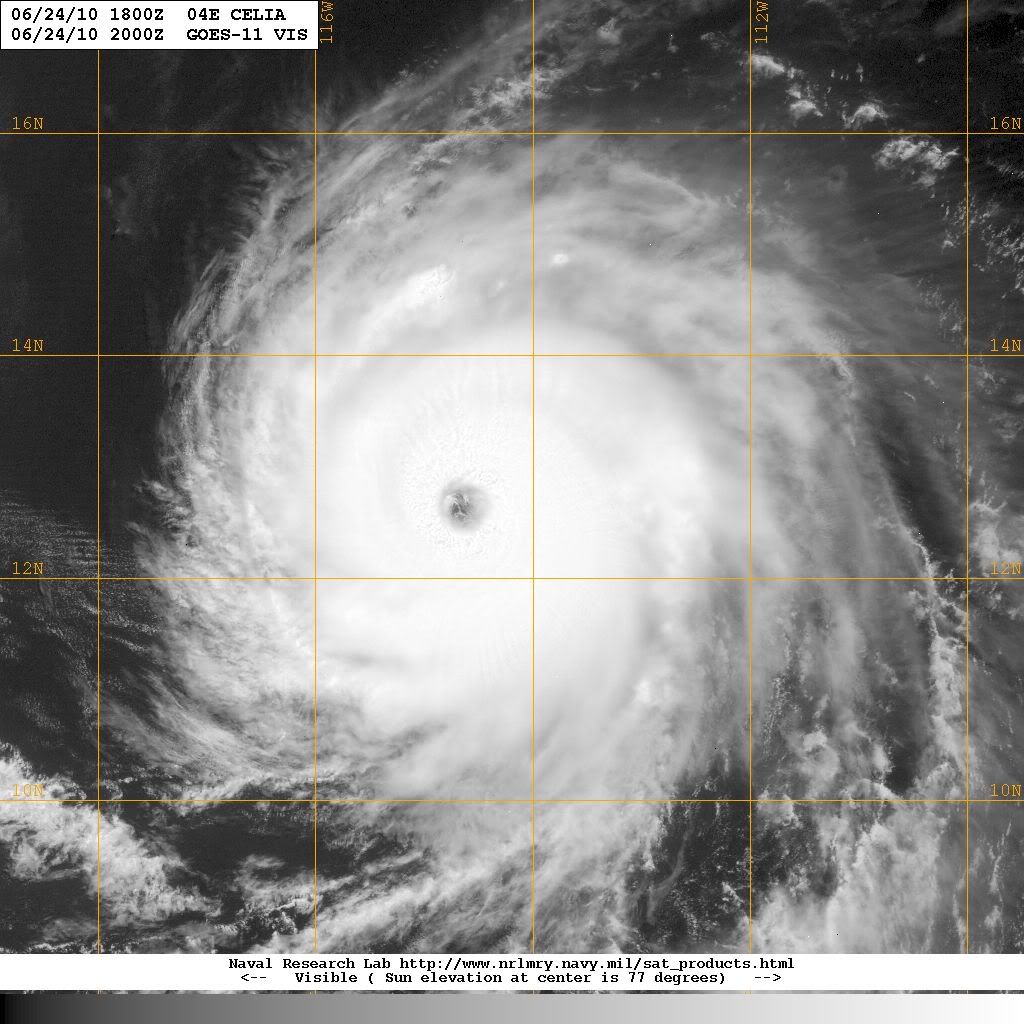
24/1800 UTC 12.5N 114.2W T6.0/6.0 CELIA -- East Pacific
0 likes
Visit the Caribbean-Central America Weather Thread where you can find at first post web cams,radars
and observations from Caribbean basin members Click Here
and observations from Caribbean basin members Click Here
-
Hurricane Andrew

- S2K Supporter

- Posts: 1891
- Age: 27
- Joined: Sun May 23, 2010 2:53 pm
- Location: KS
I knew it! I knew it would be cat 4!
Personal Forecast Disclaimer:
The posts in this forum are NOT official forecast and should not be used as such. They are just the opinion of the poster and may or may not be backed by sound meteorological data. They are NOT endorsed by any professional institution or storm2k.org. For official information, please refer to the NHC and NWS products.
Hours-Strength-Winds
0-4-135MPH
6-4-140MPH
12-4-135MPH
24-3-125MPH
48-3-115MPH
72-2-105MPH
96-1-75MPH
120-TS-50MPH
The storm is in warm SSTs and little shear but in 60 Hours+ those con ditions will worsen.
0 likes
The Enthusiast
NREMT-AEMT, WX nerd
Irene '11, Sandy '12, Irma '17 (SAR)
"Hard to think we were born to live this way..." -Wage War

Starting to lose those Annular features again, but in turn it has strengthened quite a lot as well!
0 likes
Personal Forecast Disclaimer:
The posts in this forum are NOT official forecast and should not be used as such. They are just the opinion of the poster and may or may not be backed by sound meteorological data. They are NOT endorsed by any professional institution or storm2k.org. For official information, please refer to the NHC and NWS products
The posts in this forum are NOT official forecast and should not be used as such. They are just the opinion of the poster and may or may not be backed by sound meteorological data. They are NOT endorsed by any professional institution or storm2k.org. For official information, please refer to the NHC and NWS products
-
srainhoutx

- S2K Supporter
- Posts: 6919
- Age: 68
- Joined: Sun Jan 14, 2007 11:34 am
- Location: Haywood County, NC
- Contact:
Re: EPAC : HURRICANE CELIA - DISCUSSION
0 likes
Carla/Alicia/Jerry(In The Eye)/Michelle/Charley/Ivan/Dennis/Katrina/Rita/Wilma/Ike/Harvey
Member: National Weather Association
Wx Infinity Forums
http://wxinfinity.com/index.php
Facebook.com/WeatherInfinity
Twitter @WeatherInfinity
Member: National Weather Association
Wx Infinity Forums
http://wxinfinity.com/index.php
Facebook.com/WeatherInfinity
Twitter @WeatherInfinity
-
cycloneye
- Admin
- Posts: 149727
- Age: 69
- Joined: Thu Oct 10, 2002 10:54 am
- Location: San Juan, Puerto Rico
Re: EPAC : HURRICANE CELIA - DISCUSSION
WTPZ44 KNHC 242036
TCDEP4
HURRICANE CELIA DISCUSSION NUMBER 23
NWS TPC/NATIONAL HURRICANE CENTER MIAMI FL EP042010
200 PM PDT THU JUN 24 2010
CELIA HAS CONTINUED TO STRENGTHEN TODAY...WITH THE CONVECTIVE
PATTERN NOW SYMMETRIC AND THE EYE WARMER AND MORE CIRCULAR THAN IT
WAS EARLIER. SATELLITE INTENSITY ESTIMATES FROM BOTH TAFB AND SAB
ARE 6.0/115 KT AND THE UW-CIMSS ADT ESTIMATES ARE ALSO NEAR 6.0.
BASED ON THESE CLASSIFICATIONS...THE INITIAL INTENSITY IS INCREASED
TO 115 KT...A CATEGORY FOUR HURRICANE.
THE INTENSITY MODELS...WHICH HAVE NOT PREDICTED THE INTENSIFICATION
OF CELIA WELL...CONTINUE TO SHOW VIRTUALLY NO ADDITIONAL
STRENGTHENING. HOWEVER...SINCE THE HURRICANE IS IN A LOW VERTICAL
WIND SHEAR ENVIRONMENT AND OVER WARM WATER...THE OFFICIAL FORECAST
ALLOWS FOR SOME ADDITIONAL STRENGTHENING OVER THE NEXT 12 HOURS.
BEYOND THAT TIME...CELIA WILL BE MOVING OVER STEADILY COOLER WATERS
AND INTO A MORE STABLE ATMOSPHERIC ENVIRONMENT. THIS LESS FAVORABLE
THERMODYNAMIC ENVIRONMENT SHOULD CAUSE GRADUAL WEAKENING. THE NEW
NHC INTENSITY FORECAST IS ABOVE ALL OF THE GUIDANCE IN THE SHORT
TERM AND THEN LIES CLOSEST TO THE INTENSITY MODEL CONSENSUS BEYOND
36 HOURS.
THE INITIAL MOTION ESTIMATE IS 280/10...AND THE EYE OF CELIA LIES
ALONG THE PREVIOUS FORECAST TRACK. CELIA IS EXPECTED TO TRACK
WEST-NORTHWESTWARD OVER THE NEXT FEW DAYS AS A LARGE-SCALE MID- TO
UPPER-LEVEL TROUGH OFFSHORE OF THE UNITED STATES WEST COAST ERODES
THE MID-LEVEL RIDGE TO THE NORTH OF THE HURRICANE. BEYOND A FEW
DAYS...CELIA IS FORECAST TO TURN WESTWARD AND SLOW IN FORWARD SPEED
AS THE TROUGH LIFTS OUT AND STEERING CURRENTS BECOME WEAK. THE NEW
NHC OFFICIAL FORECAST IS BASICALLY AN UPDATE OF THE PREVIOUS ONE
BUT SHOWS A SLOWER MOTION AT THE END OF THE FORECAST PERIOD.
THE 34-KT AND 50-KT WIND RADII HAVE BEEN ADJUSTED INWARD BASED ON AN
ASCAT PASS AT 1658 UTC.
FORECAST POSITIONS AND MAX WINDS
INITIAL 24/2100Z 12.8N 114.7W 115 KT
12HR VT 25/0600Z 13.4N 116.4W 120 KT
24HR VT 25/1800Z 14.1N 118.4W 110 KT
36HR VT 26/0600Z 15.0N 120.2W 95 KT
48HR VT 26/1800Z 15.6N 121.7W 80 KT
72HR VT 27/1800Z 16.5N 124.0W 55 KT
96HR VT 28/1800Z 16.5N 125.5W 40 KT
120HR VT 29/1800Z 16.5N 126.5W 30 KT
$$
FORECASTER CANGIALOSI
0 likes
Visit the Caribbean-Central America Weather Thread where you can find at first post web cams,radars
and observations from Caribbean basin members Click Here
and observations from Caribbean basin members Click Here


Who is online
Users browsing this forum: No registered users and 33 guests