ATL : INVEST 92L - DISCUSSION

Moderator: S2k Moderators

Message
Author
lonelymike
S2K Supporter
S2K Supporter
Posts: 634
Joined: Sat Jul 26, 2008 10:12 am
Location: walton county fla

Re: ATL : INVEST 92L - Discussion

#521 Postby lonelymike » Mon Jun 14, 2010 9:42 pm

wxman57 wrote:
Ivanhater wrote:
lonelymike wrote:Don't worry the fat lady is warming up, Bones is on call and wxman57 will be along tomorrow to shatter another hurricane fantasy of many a young and promising youth :cheesy:

Ivanhater: The work goes on and the dream never dies 8-)


Regardless if 92L develops or not, it is a very bad sign of things to come this season. We should not even be having a possibility of something developing this time of year in this location anyway.

I have a feeling Bones will not be showing up often this season :wink:

Oh, the wave behind this one looks good as well, and it's June ...


Bones tells me he'll be taking a vacation from August through September.


Well hopefully Bones cousins Dry Air and Mr. Steering Flow will hang around for August and September. :D
0 likes   


GO SEMINOLES

User avatar
MGC
S2K Supporter
S2K Supporter
Posts: 5899
Joined: Sun Mar 23, 2003 9:05 pm
Location: Pass Christian MS, or what is left.

Re: ATL : INVEST 92L - Discussion

#522 Postby MGC » Mon Jun 14, 2010 9:43 pm

Nice burst of convection near the apparent circulation center this evening. The convection might be a transitory feature though.....I doubt the convection persists.
Does look like 92L will struggle with some shear the next few days. Chances of development have decreased since yesterday....but you never know what nature will do.......MGC
0 likes   

User avatar
wxman57
Moderator-Pro Met
Moderator-Pro Met
Posts: 22979
Age: 67
Joined: Sat Jun 21, 2003 8:06 pm
Location: Houston, TX (southwest)

Re: ATL : INVEST 92L - Discussion

#523 Postby wxman57 » Mon Jun 14, 2010 9:50 pm

Convection looks quite weak, limited, and diminishing this evening. Not impressive at all. I can sleep in. Night all.
0 likes   

User avatar
cycloneye
Admin
Admin
Posts: 145322
Age: 68
Joined: Thu Oct 10, 2002 10:54 am
Location: San Juan, Puerto Rico

Re: ATL : INVEST 92L - Discussion

#524 Postby cycloneye » Mon Jun 14, 2010 9:51 pm

57,what do you think about this? :lol:

Image
0 likes   
Visit the Caribbean-Central America Weather Thread where you can find at first post web cams,radars
and observations from Caribbean basin members Click Here

User avatar
NDG
S2K Supporter
S2K Supporter
Posts: 15446
Joined: Sun Jul 09, 2006 10:14 pm
Location: Orlando, FL

Re:

#525 Postby NDG » Mon Jun 14, 2010 9:53 pm

gatorcane wrote:
The posts in this forum are NOT official forecast and should not be used as such. They are just the opinion of the poster and may or may not be backed by sound meteorological data. They are NOT endorsed by any professional institution or storm2k.org. For official information, please refer to the NHC and NWS products.


Looked over the data again (including posts in this thread from throughout the day). I get the feeling that many are trying to find some glimmer of "hope" for 92L. The reality is that the chances of 92L developing now are quite low and I really expect NHC to give it a code yellow by this time tomorrow, if not sooner. Model support is quite lousy still. In fact I have seen some claim the GFS is not getting this right. It so far has performed excellent with 92L. It keeps it as a wave and does not develop it at all. Of course, down the road perhaps 5 days from now it may find itself it a more favorable environment but doesn't nearly every wave headed towards the Western Caribbean this time of year have some kind of potential? We have plenty of time to watch this so I have absolutely no concern about 92L at this time.

What I don't get is that 92E in the EPAC looks like it could very-well become the next named system down the road but there is relatively no interest in the EPAC system compared to 92L. Convection is quite nice, model support is there. If you want to see an invest with real potential, look at this one.


Probably because 92E is nothing but a naked swirl right now, being knocked out be easterly shear.
0 likes   

User avatar
LSU2001
S2K Supporter
S2K Supporter
Posts: 1711
Age: 57
Joined: Sat Sep 11, 2004 11:01 pm
Location: Cut Off, Louisiana

Re: ATL : INVEST 92L - Discussion

#526 Postby LSU2001 » Mon Jun 14, 2010 10:04 pm

I would think that 92L is toast if it does not get it's act together real fast. But as other posters have said never say never in the tropics :lol:

Also in 2005 I seem to remember an exTD #10 that caused a bit of trouble after reforming.
Tim
0 likes   
Personal Forecast Disclaimer:
The posts in this forum are NOT official forecast and should not be used as such. They are NOT endorsed by any professional institution or storm2k.org. For official information, please refer to the NHC and NWS products.

User avatar
ConvergenceZone
Category 5
Category 5
Posts: 5194
Joined: Fri Jul 29, 2005 1:40 am
Location: Northern California

#527 Postby ConvergenceZone » Mon Jun 14, 2010 10:07 pm

I think June is acting exactly like June suppose to be acting. Tropical waves encountering shear...So far, this is a typical June as to be expected.... Wait until August though :)....
0 likes   

User avatar
cycloneye
Admin
Admin
Posts: 145322
Age: 68
Joined: Thu Oct 10, 2002 10:54 am
Location: San Juan, Puerto Rico

Re: ATL : INVEST 92L - Discussion

#528 Postby cycloneye » Mon Jun 14, 2010 10:27 pm

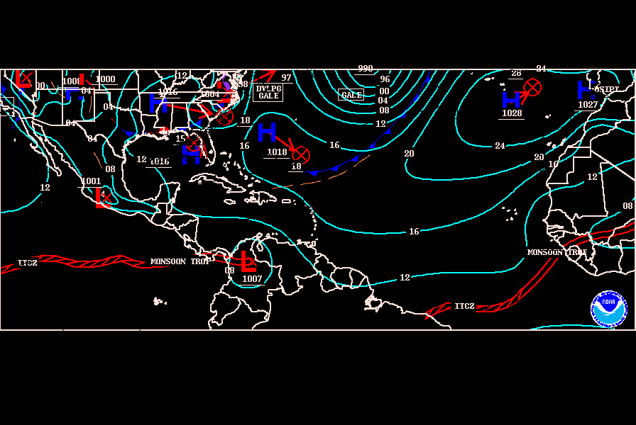
Here is the 00z surface analysis by TAFB.Has the low pressure moving west.

Image
0 likes   
Visit the Caribbean-Central America Weather Thread where you can find at first post web cams,radars
and observations from Caribbean basin members Click Here

User avatar
canetracker
S2K Supporter
S2K Supporter
Posts: 751
Age: 62
Joined: Wed Jul 27, 2005 8:49 pm
Location: Suburbia New Orleans...Harahan, LA

Re: Re:

#529 Postby canetracker » Mon Jun 14, 2010 10:32 pm

NDG wrote:
gatorcane wrote:
The posts in this forum are NOT official forecast and should not be used as such. They are just the opinion of the poster and may or may not be backed by sound meteorological data. They are NOT endorsed by any professional institution or storm2k.org. For official information, please refer to the NHC and NWS products.


Looked over the data again (including posts in this thread from throughout the day). I get the feeling that many are trying to find some glimmer of "hope" for 92L. The reality is that the chances of 92L developing now are quite low and I really expect NHC to give it a code yellow by this time tomorrow, if not sooner. Model support is quite lousy still. In fact I have seen some claim the GFS is not getting this right. It so far has performed excellent with 92L. It keeps it as a wave and does not develop it at all. Of course, down the road perhaps 5 days from now it may find itself it a more favorable environment but doesn't nearly every wave headed towards the Western Caribbean this time of year have some kind of potential? We have plenty of time to watch this so I have absolutely no concern about 92L at this time.

What I don't get is that 92E in the EPAC looks like it could very-well become the next named system down the road but there is relatively no interest in the EPAC system compared to 92L. Convection is quite nice, model support is there. If you want to see an invest with real potential, look at this one.

Probably because 92E is nothing but a naked swirl right now, being knocked out be easterly shear.


Good call NDG...shear is controlling both the EPAC and WPAC right now.
0 likes   

User avatar
ConvergenceZone
Category 5
Category 5
Posts: 5194
Joined: Fri Jul 29, 2005 1:40 am
Location: Northern California

#530 Postby ConvergenceZone » Mon Jun 14, 2010 10:58 pm

I"m actually not suprised that 92L and the wave that emerged off of Africa are both falling apart. We knew something wasn't right being that it's June. It just wouldn't have been right for have a cape verde storm form this early in the season.... Shear is dominating now, but this is very normal for June. So at least it looks like we are going to have a normal June anyway......
0 likes   

tolakram
Admin
Admin
Posts: 20009
Age: 62
Joined: Sun Aug 27, 2006 8:23 pm
Location: Florence, KY (name is Mark)

Re: ATL : INVEST 92L - Discussion

#531 Postby tolakram » Mon Jun 14, 2010 11:05 pm

To add to possible reasons for decreased convection, the oceanic heat content is lower than it was last night.

Image
0 likes   
M a r k
- - - - -
Join us in chat: Storm2K Chatroom Invite. Android and IOS apps also available.

The posts in this forum are NOT official forecasts and should not be used as such. Posts are NOT endorsed by any professional institution or STORM2K.org. For official information and forecasts, please refer to NHC and NWS products.

User avatar
HURAKAN
Professional-Met
Professional-Met
Posts: 46086
Age: 38
Joined: Thu May 20, 2004 4:34 pm
Location: Key West, FL
Contact:

#532 Postby HURAKAN » Mon Jun 14, 2010 11:08 pm

Image

Latest
0 likes   

User avatar
Ivanhater
Storm2k Moderator
Storm2k Moderator
Posts: 11161
Age: 38
Joined: Fri Jul 01, 2005 8:25 am
Location: Pensacola

Re: ATL : INVEST 92L - Discussion

#533 Postby Ivanhater » Tue Jun 15, 2010 12:20 am

BACK UP TO 50 PERCENT

000
ABNT20 KNHC 150513
TWOAT
TROPICAL WEATHER OUTLOOK
NWS TPC/NATIONAL HURRICANE CENTER MIAMI FL
200 AM EDT TUE JUN 15 2010

FOR THE NORTH ATLANTIC...CARIBBEAN SEA AND THE GULF OF MEXICO...

A LOW PRESSURE SYSTEM LOCATED ABOUT 1150 MILES EAST OF THE LESSER
ANTILLES HAS BECOME A LITTLE BETTER ORGANIZED DURING THE PAST
SEVERAL HOURS. ENVIRONMENTAL CONDITIONS ARE EXPECTED TO REMAIN
MARGINALLY FAVORABLE FOR THIS SYSTEM TO BECOME A TROPICAL
DEPRESSION TODAY BEFORE UPPER-LEVEL WINDS BECOME LESS FAVORABLE ON
WEDNESDAY.
THERE IS A MEDIUM CHANCE...50 PERCENT...OF THIS SYSTEM
BECOMING A TROPICAL CYCLONE DURING THE NEXT 48 HOURS AS IT MOVES
WEST-NORTHWESTWARD TO NORTHWESTWARD AT ABOUT 15 MPH.

ELSEWHERE...TROPICAL CYCLONE FORMATION IS NOT EXPECTED DURING THE
NEXT 48 HOURS.

$$
FORECASTER STEWART/BLAKE
0 likes   
Michael

User avatar
Ivanhater
Storm2k Moderator
Storm2k Moderator
Posts: 11161
Age: 38
Joined: Fri Jul 01, 2005 8:25 am
Location: Pensacola

Re: ATL : INVEST 92L - Discussion

#534 Postby Ivanhater » Tue Jun 15, 2010 12:21 am

New TFCA Alert issued


ALERT ATCF MIL 92X XXX 100614180000
2010061418
10.7 318.3
13.0 313.9
100
10.4 319.1
150600
1006150530
1
WTNT01 KNGU 150600
SUBJ/TROPICAL CYCLONE FORMATION ALERT 150530Z JUN 10//
REF/A/MSG/NAVMARFCSTCEN/140530ZJUN10//
AMPN/REF IS TROPICAL CYCLONE FORMATION ALERT (WTNT01 KNGU 140600)//
RMKS/1. FORMATION OF A SIGNIFICANT TROPICAL CYCLONE IS POSSIBLE WITHIN
100 NM EITHER SIDE OF A LINE FROM 10.7N 41.7W TO 13.0N 46.1W
WITHIN THE NEXT 12 TO 24 HOURS. AVAILABLE DATA DOES NOT JUSTIFY
ISSUANCE OF NUMBERED TROPICAL CYCLONE WARNINGS AT THIS TIME.
WINDS IN THE AREA ARE ESTIMATED TO BE 15 TO 25 KNOTS. METSAT IM-
AGERY AT 150000Z INDICATES THAT A CIRCULATION CENTER IS LOCATED
NEAR 10.4N 41.2W. THE SYSTEM IS MOVING WEST-NORTHWESTWARD AT 12
KNOTS.
2. REMARKS: A LOW PRESSURE CENTER LOCATED NEAR 10.4N 41.2W IS CURRENTLY
MOVING WEST-NORTHWEST AT APPROXIMATELY 12 KNOTS. AT 15/0000Z INFARED
SATELLITE IMAGERY INDICATED AN AREA OF CONVECTION HAS BECOME BETTER
ORGANIZED WITHIN THE PAST 6 HOURS. THIS SYSTEM IS CURRENTLY EXPERIENCING
LOW WIND SHEER, UPPER LEVEL ANTICYCLONE OUTFLOW, AND WARM SEA SURFACE
TEMPERATURES OF 82 TO 85 DEGREES FAHRENHEIT PRODUCING FAVORABLE CONDITIONS
FOR DEVELOPMENT. THIS AREA OF LOW PRESSURE HOWEVER, IS EXPECTED TO TRACK INTO
INCREASED WIND SHEAR WITHIN THE NEXT 24 TO 48 HOURS INHIBITING THE
INTENSIFICATION OF THE SYSTEM.
3. THIS ALERT WILL BE REISSUED, UPGRADED TO WARNING OR CANCELLED
BY 160600Z.//
9210061118 60N 275W 20
9210061200 61N 284W 20
9210061206 61N 293W 20
9210061212 62N 301W 20
9210061218 63N 310W 25
9210061300 64N 321W 20
9210061306 67N 335W 25
9210061312 71N 349W 25
9210061318 77N 363W 25
9210061400 84N 376W 25
9210061406 90N 388W 25
9210061412 97N 399W 25
9210061418 104N 409W 25
0 likes   
Michael

Brent
S2K Supporter
S2K Supporter
Posts: 38090
Age: 36
Joined: Sun May 16, 2004 10:30 pm
Location: Tulsa Oklahoma
Contact:

Re: ATL : INVEST 92L - Discussion

#535 Postby Brent » Tue Jun 15, 2010 12:26 am

Ivanhater wrote:BACK UP TO 50 PERCENT

000
ABNT20 KNHC 150513
TWOAT
TROPICAL WEATHER OUTLOOK
NWS TPC/NATIONAL HURRICANE CENTER MIAMI FL
200 AM EDT TUE JUN 15 2010

FOR THE NORTH ATLANTIC...CARIBBEAN SEA AND THE GULF OF MEXICO...

A LOW PRESSURE SYSTEM LOCATED ABOUT 1150 MILES EAST OF THE LESSER
ANTILLES HAS BECOME A LITTLE BETTER ORGANIZED DURING THE PAST
SEVERAL HOURS. ENVIRONMENTAL CONDITIONS ARE EXPECTED TO REMAIN
MARGINALLY FAVORABLE FOR THIS SYSTEM TO BECOME A TROPICAL
DEPRESSION TODAY BEFORE UPPER-LEVEL WINDS BECOME LESS FAVORABLE ON
WEDNESDAY.
THERE IS A MEDIUM CHANCE...50 PERCENT...OF THIS SYSTEM
BECOMING A TROPICAL CYCLONE DURING THE NEXT 48 HOURS AS IT MOVES
WEST-NORTHWESTWARD TO NORTHWESTWARD AT ABOUT 15 MPH.

ELSEWHERE...TROPICAL CYCLONE FORMATION IS NOT EXPECTED DURING THE
NEXT 48 HOURS.

$$
FORECASTER STEWART/BLAKE


That was an interesting update. First time they have actually said a TD could form.
0 likes   
#neversummer

User avatar
Ivanhater
Storm2k Moderator
Storm2k Moderator
Posts: 11161
Age: 38
Joined: Fri Jul 01, 2005 8:25 am
Location: Pensacola

Re: ATL : INVEST 92L - Discussion

#536 Postby Ivanhater » Tue Jun 15, 2010 12:27 am

leads me to believe they want to classify it when visible comes out, IF it can hold overnight. We will see though
0 likes   
Michael

I-wall
Tropical Storm
Tropical Storm
Posts: 210
Joined: Wed Sep 10, 2008 5:24 pm

Re: ATL : INVEST 92L - Discussion

#537 Postby I-wall » Tue Jun 15, 2010 12:31 am

This thing is looking pretty good right now. The convection is wrapping around the western half and there appears to be a nice band in the western half. Looks like it has a nice, tight circulation now.

Image
0 likes   

User avatar
Ivanhater
Storm2k Moderator
Storm2k Moderator
Posts: 11161
Age: 38
Joined: Fri Jul 01, 2005 8:25 am
Location: Pensacola

Re: ATL : INVEST 92L - Discussion

#538 Postby Ivanhater » Tue Jun 15, 2010 12:41 am

Well, this may be named or not, but this is likely a TD now and has been (imo). NHC tends not to name these without making sure it wont poof soon after. Having this system this far out is incredible in my book.
0 likes   
Michael

I-wall
Tropical Storm
Tropical Storm
Posts: 210
Joined: Wed Sep 10, 2008 5:24 pm

Re: ATL : INVEST 92L - Discussion

#539 Postby I-wall » Tue Jun 15, 2010 12:47 am

Ivanhater wrote:Well, this may be named or not, but this is likely a TD now and has been (imo). NHC tends not to name these without making sure it wont poof soon after. Having this system this far out is incredible in my book.

My thoughts exactly.
0 likes   

User avatar
Cyclenall
Category 5
Category 5
Posts: 6666
Joined: Thu Jun 08, 2006 10:01 pm
Location: Ontario, Canada

Re:

#540 Postby Cyclenall » Tue Jun 15, 2010 12:53 am

Why did I get the feeling before entering in here there was going to be a lot of "It's done for" posts on 92L because of the events of yesterday? :roll: Posts before 12 am EDT were all pessimistic about 92L's chances but then the flip switched :wink: .

It's actually been improving for hours now because the convection is covering more of the system which appears to be much tighter than two days ago.

ConvergenceZone wrote:I"m actually not suprised that 92L and the wave that emerged off of Africa are both falling apart. We knew something wasn't right being that it's June. It just wouldn't have been right for have a cape verde storm form this early in the season.... Shear is dominating now, but this is very normal for June. So at least it looks like we are going to have a normal June anyway......

There is nothing typical about this June at all, just take a look at the water vapor maps for the eastern part of the Atlantic basin...have you ever seen anything like that in the middle of June? It might turn out to be typical in terms of number of named storms for June but the conditions are opposite to that.
0 likes   


Return to “2010”

Who is online

Users browsing this forum: No registered users and 7 guests