
ATL : INVEST 92L - DISCUSSION
Moderator: S2k Moderators
-
gatorcane

- S2K Supporter

- Posts: 23708
- Age: 48
- Joined: Sun Mar 13, 2005 3:54 pm
- Location: Boca Raton, FL
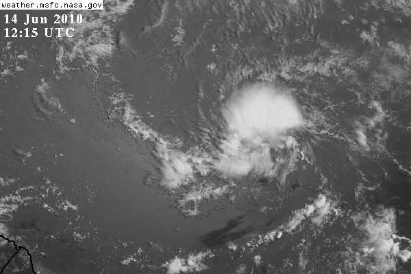
Another thing to pay attention to is dry air that is also awaiting the arrival of 92L. It's also sitting out around 50W as you can see in the image below (see orange colors). ECMWF and GFS really don't like this system at all any longer calling for no development now. Some nice convection has fired up overnight but I am expecting 92L to gradually begin a trend of less organization going forward probably starting in around 48 hours from now. It's got a chance until then and basically little to no chance to sustain anything after that. Still may not even become a named system, which has been my thinking since the beginning.
Last edited by gatorcane on Mon Jun 14, 2010 6:49 am, edited 1 time in total.
0 likes
-
cycloneye

- Admin

- Posts: 149730
- Age: 69
- Joined: Thu Oct 10, 2002 10:54 am
- Location: San Juan, Puerto Rico
Re: ATL : INVEST 92L - Discussion
TWOAT
TROPICAL WEATHER OUTLOOK
NWS TPC/NATIONAL HURRICANE CENTER MIAMI FL
800 AM EDT MON JUN 14 2010
FOR THE NORTH ATLANTIC...CARIBBEAN SEA AND THE GULF OF MEXICO...
AN AREA OF LOW PRESSURE LOCATED ABOUT 1425 MILES EAST-SOUTHEAST
OF THE WINDWARD ISLANDS CONTINUES TO SHOW SIGNS OF ORGANIZATION.
ENVIRONMENTAL CONDITIONS ARE EXPECTED TO REMAIN CONDUCIVE FOR
DEVELOPMENT DURING THE NEXT DAY OR SO AS THE SYSTEM MOVES
WEST-NORTHWESTWARD TO NORTHWESTWARD AT ABOUT 15 MPH. THERE
REMAINS A HIGH CHANCE...60 PERCENT...OF THIS SYSTEM BECOMING A
TROPICAL CYCLONE DURING THE NEXT 48 HOURS.
ELSEWHERE...TROPICAL CYCLONE FORMATION IS NOT EXPECTED DURING THE
NEXT 48 HOURS.
$$
FORECASTER BROWN/KIMBERLAIN
0 likes
Visit the Caribbean-Central America Weather Thread where you can find at first post web cams,radars
and observations from Caribbean basin members Click Here
and observations from Caribbean basin members Click Here


-
gatorcane
- S2K Supporter
- Posts: 23708
- Age: 48
- Joined: Sun Mar 13, 2005 3:54 pm
- Location: Boca Raton, FL
Re:
bob rulz wrote:Yeah there was definitely a significant size reduction! It shed a lot of the moisture envelope surrounding it.
I'm surprised that the NHC didn't increase the development chances but I don't blame them for being hesitant, given the time and location.
Not surprising at all really. Note the discussion is mentioning a timeframe for development (1-2 days). That's when the upper-level conditions are favorable. Here is in this loop you can see can really see the southeasten-edge of the TUTT (shear). Look at the high clouds on this IR loop streaming from the Leewards to off to the ENE just NW of 92L, fairly quickly. 92L is headed for that and dry air and just can't see it surviving that. It's like a wall of defense that may very well protect the Leewards and points west from anything significant out of 92L.
http://www.ssd.noaa.gov/goes/east/catl/loop-avn.html
0 likes
-
Blown Away

- S2K Supporter
- Posts: 10253
- Joined: Wed May 26, 2004 6:17 am
Re: ATL : INVEST 92L - Discussion
The overall moisture envelope has decreased as 92L is consolidating. I find it interesting a few models including now the GFDL maintain 92L as a TS through the dry air & shear area just ahead. Conditions beyond 60W are decent and if 92L can build a tighter inner core the chances of surviving the hostile conditions will be higher. IMO, 92L still 2 days from the hostile conditions and if the shear drops a little 92L will have no problem maintaining. Currently, 92L has begun to build some deeper thunderstorms (reds) and if this continues we may see a TD today.
0 likes
Hurricane Eye Experience: David 79, Irene 99, Frances 04, Jeanne 04, Wilma 05… Hurricane Brush Experience: Andrew 92, Erin 95, Floyd 99, Matthew 16, Irma 17, Ian 22, Nicole 22…
-
hurricanefloyd5

- Category 5

- Posts: 1659
- Age: 45
- Joined: Sun May 02, 2004 10:53 am
- Location: Spartanburg
- Contact:
-
cycloneye
- Admin
- Posts: 149730
- Age: 69
- Joined: Thu Oct 10, 2002 10:54 am
- Location: San Juan, Puerto Rico
Re: ATL : INVEST 92L - Discussion
12 UTC Best Track
Almost at 10N.
AL, 92, 2010061412, , BEST, 0, 97N, 399W, 25, 1011, DB
ftp://ftp.tpc.ncep.noaa.gov/atcf/tcweb/
Almost at 10N.
AL, 92, 2010061412, , BEST, 0, 97N, 399W, 25, 1011, DB
ftp://ftp.tpc.ncep.noaa.gov/atcf/tcweb/
0 likes
Visit the Caribbean-Central America Weather Thread where you can find at first post web cams,radars
and observations from Caribbean basin members Click Here
and observations from Caribbean basin members Click Here
-
Blown Away
- S2K Supporter
- Posts: 10253
- Joined: Wed May 26, 2004 6:17 am
Re: ATL : INVEST 92L - Discussion
Good cyclonic rotation with persistent deep thunderstorms around the circulation center, 92L has got to be nearing TD status.
0 likes
Hurricane Eye Experience: David 79, Irene 99, Frances 04, Jeanne 04, Wilma 05… Hurricane Brush Experience: Andrew 92, Erin 95, Floyd 99, Matthew 16, Irma 17, Ian 22, Nicole 22…

Re: ATL : INVEST 92L - Discussion
yeah it's developing a CDO structure now. It won't be long before we have TD 1 - it may already be there now.
http://www.ssd.noaa.gov/goes/east/catl/flash-avn.html
http://www.ssd.noaa.gov/goes/east/catl/flash-avn.html
0 likes
-
cycloneye
- Admin
- Posts: 149730
- Age: 69
- Joined: Thu Oct 10, 2002 10:54 am
- Location: San Juan, Puerto Rico
Re: ATL : INVEST 92L - Discussion
So far this has not come yet BEGIN
NHC_ATCF
invest_RENUMBER so no TD at 11 AM,unless they quickly upgrade.I think they will wait to see if convection persists more before 5 PM.
NHC_ATCF
invest_RENUMBER so no TD at 11 AM,unless they quickly upgrade.I think they will wait to see if convection persists more before 5 PM.
0 likes
Visit the Caribbean-Central America Weather Thread where you can find at first post web cams,radars
and observations from Caribbean basin members Click Here
and observations from Caribbean basin members Click Here

-
Blown Away
- S2K Supporter
- Posts: 10253
- Joined: Wed May 26, 2004 6:17 am
Re: ATL : INVEST 92L - Discussion
cycloneye wrote:So far this has not come yet BEGIN
NHC_ATCF
invest_RENUMBER so no TD at 11 AM,unless they quickly upgrade.I think they will wait to see if convection persists more before 5 PM.
The media is just waiting for this to happen and if it does the 5 day cone will point towards the islands and in the general direction of the GOM spill and that will create a huge news story regardless of the storms intensity predictions. I agree they will wait for persistence before pulling that trigger!
0 likes
Hurricane Eye Experience: David 79, Irene 99, Frances 04, Jeanne 04, Wilma 05… Hurricane Brush Experience: Andrew 92, Erin 95, Floyd 99, Matthew 16, Irma 17, Ian 22, Nicole 22…
-
JonathanBelles
- Professional-Met

- Posts: 11430
- Age: 35
- Joined: Sat Dec 24, 2005 9:00 pm
- Location: School: Florida State University (Tallahassee, FL) Home: St. Petersburg, Florida
- Contact:
-
senorpepr

- Military Met/Moderator

- Posts: 12542
- Age: 43
- Joined: Fri Aug 22, 2003 9:22 pm
- Location: Mackenbach, Germany
- Contact:
Re:
fact789 wrote:Hello from 37,000 feet over northern Mississippi moving at 550mph!! I am doing a quick analysis of 92L, and will have a short forecast available soon. It will be abbreviated due to my altitude and speed in relation with the ground lol.
See how addictive Storm2k is?! Folks are logging in from aircraft!
92L has really consolidated overnight with convection flaring nicely now... I'm gaining a little more confidence in this system...
0 likes
-
Dean4Storms
- S2K Supporter
- Posts: 6358
- Age: 63
- Joined: Sun Aug 31, 2003 1:01 pm
- Location: Miramar Bch. FL


Re: ATL : INVEST 92L - Discussion
Blown Away wrote:cycloneye wrote:So far this has not come yet BEGIN
NHC_ATCF
invest_RENUMBER so no TD at 11 AM,unless they quickly upgrade.I think they will wait to see if convection persists more before 5 PM.
The media is just waiting for this to happen and if it does the 5 day cone will point towards the islands and in the general direction of the GOM spill and that will create a huge news story regardless of the storms intensity predictions. I agree they will wait for persistence before pulling that trigger!
Agreed, remember if a Hurricane does enter the Gulf of Mexico and they have to seek shelter at the DeepWater Horizon site, they have to move the ships AND the cap presently over the riser pipe. It will then be free flowing 100% and who knows what will happen to the relief rig trying to intersect the present well underground if a Rita or Katrina hits it. You've seen the pictures of rigs all bent up after those Hurricanes.
0 likes
-
Stormcenter
- S2K Supporter
- Posts: 6689
- Joined: Wed Sep 03, 2003 11:27 am
- Location: Houston, TX
Who is online
Users browsing this forum: No registered users and 40 guests