ATL : INVEST 92L - DISCUSSION

Moderator: S2k Moderators

Message
Author
User avatar
Hurricane Andrew
S2K Supporter
S2K Supporter
Posts: 1891
Age: 26
Joined: Sun May 23, 2010 2:53 pm
Location: KS

Re:

#281 Postby Hurricane Andrew » Sun Jun 13, 2010 7:10 pm

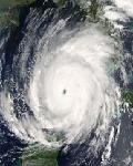
SeminoleWind wrote:what are the realistic chances that this can stay organized and make it to the islands?

Belive it or not, this is my forcast.

Personal Forecast Disclaimer:
The posts in this forum are NOT official forecast and should not be used as such. They are just the opinion of the poster and may or may not be backed by sound meteorological data. They are NOT endorsed by any professional institution or storm2k.org. For official information, please refer to the NHC and NWS products.

Dissipating-20%
island/east Carribean-50%
East coast-20%
OTS-10%
0 likes   

The Enthusiast
NREMT-AEMT, WX nerd

Irene '11, Sandy '12, Irma '17 (SAR)

"Hard to think we were born to live this way..." -Wage War

User avatar
cycloneye
Admin
Admin
Posts: 145303
Age: 68
Joined: Thu Oct 10, 2002 10:54 am
Location: San Juan, Puerto Rico

Re: ATL : INVEST 92L

#282 Postby cycloneye » Sun Jun 13, 2010 7:10 pm

From 8 PM EDT discussion:

BASED ON 1800 UTC SURFACE ANALYSIS AND SATELLITE IMAGERY THROUGH
2315 UTC...

...SPECIAL FEATURES...

A BROAD AREA OF CYCLONIC CIRCULATION IS IN THE CENTRAL TROPICAL
ATLANTIC ABOUT 975 NM WSW OF THE CAPE VERDE ISLANDS...FOCUSED ON
A 1010 MB SURFACE LOW CENTERED NEAR 7N37W. THE SYSTEM IS
EMBEDDED IN A LARGE AREA OF DEEP LAYER MOISTURE EVIDENT IN TOTAL
PRECIPITABLE WATER IMAGERY. SCATTERED MODERATE/STRONG CONVECTION
IS N AND NE OF THE LOW CENTER FROM 8N-10N BETWEEN 34W-38W...AND
FROM 10N-12N BETWEEN 30W-34W. SCATTERED MODERATE/ISOLATED STRONG
CONVECTION IS FROM 2N-8N BETWEEN 35W-39W...AND FROM 8N-12N
BETWEEN 38W-42W. THE SYSTEM CONTINUES TO HAVE GOOD ENVIRONMENTAL
CONDITIONS CONDUCIVE FOR FURTHER DEVELOPMENT. THERE IS CURRENTLY
A HIGH CHANCE...60 PERCENT...OF THIS SYSTEM BECOMING A TROPICAL
CYCLONE DURING THE NEXT 48 HRS.
0 likes   
Visit the Caribbean-Central America Weather Thread where you can find at first post web cams,radars
and observations from Caribbean basin members Click Here

User avatar
Hurricane Andrew
S2K Supporter
S2K Supporter
Posts: 1891
Age: 26
Joined: Sun May 23, 2010 2:53 pm
Location: KS

#283 Postby Hurricane Andrew » Sun Jun 13, 2010 7:10 pm

Note-You 98 guests out there, come and join the fun!
0 likes   

The Enthusiast
NREMT-AEMT, WX nerd

Irene '11, Sandy '12, Irma '17 (SAR)

"Hard to think we were born to live this way..." -Wage War

User avatar
Gustywind
Category 5
Category 5
Posts: 12334
Joined: Mon Sep 03, 2007 7:29 am
Location: Baie-Mahault, GUADELOUPE

#284 Postby Gustywind » Sun Jun 13, 2010 7:11 pm

:uarrow:
Red Code
Image
0 likes   

User avatar
Duddy
Category 1
Category 1
Posts: 363
Joined: Sat Jun 10, 2006 9:07 pm
Location: Wilmington, NC

Re: ATL : INVEST 92L

#285 Postby Duddy » Sun Jun 13, 2010 7:12 pm

Wow look at the wave behind it!
0 likes   

jaxfladude
Category 5
Category 5
Posts: 1249
Joined: Wed Aug 24, 2005 9:36 pm
Location: Jacksonville, Fla

#286 Postby jaxfladude » Sun Jun 13, 2010 7:13 pm

Bad Omen Alert for the Rest of the Season?!
0 likes   

User avatar
Gustywind
Category 5
Category 5
Posts: 12334
Joined: Mon Sep 03, 2007 7:29 am
Location: Baie-Mahault, GUADELOUPE

Re: ATL : INVEST 92L

#287 Postby Gustywind » Sun Jun 13, 2010 7:14 pm

Duddy wrote:Wow look at the wave behind it!

Image
0 likes   

User avatar
Cdeck81
Tropical Low
Tropical Low
Posts: 20
Age: 28
Joined: Sat May 29, 2010 9:40 pm
Location: Beaumont, TX

Re:

#288 Postby Cdeck81 » Sun Jun 13, 2010 7:14 pm

Hurricane Andrew wrote:Note-You 98 guests out there, come and join the fun!

I'm only 13 and I'm having tons of fun! :D
0 likes   
____________________________
I survived Allison, Rita, Humberto, Edouard, and Ike.

User avatar
Hurricane Andrew
S2K Supporter
S2K Supporter
Posts: 1891
Age: 26
Joined: Sun May 23, 2010 2:53 pm
Location: KS

Re: Re:

#289 Postby Hurricane Andrew » Sun Jun 13, 2010 7:15 pm

Cdeck81 wrote:
Hurricane Andrew wrote:Note-You 98 guests out there, come and join the fun!

I'm only 13 and I'm having tons of fun! :D

???

Anyway..i think wave#2 sould be Invest 93, and code yellow. agreed?
0 likes   

The Enthusiast
NREMT-AEMT, WX nerd

Irene '11, Sandy '12, Irma '17 (SAR)

"Hard to think we were born to live this way..." -Wage War

Explorer93
Tropical Low
Tropical Low
Posts: 11
Joined: Sun Jun 13, 2010 12:47 am
Location: Pensacola, FL

Re: ATL : INVEST 92L

#290 Postby Explorer93 » Sun Jun 13, 2010 7:16 pm

I have no knowledge in sheer, but does models show sheer breaking up, and allowing systems to develop any time soon?
0 likes   

User avatar
Cdeck81
Tropical Low
Tropical Low
Posts: 20
Age: 28
Joined: Sat May 29, 2010 9:40 pm
Location: Beaumont, TX

Re: Re:

#291 Postby Cdeck81 » Sun Jun 13, 2010 7:17 pm

Hurricane Andrew wrote:
Cdeck81 wrote:
Hurricane Andrew wrote:Note-You 98 guests out there, come and join the fun!

I'm only 13 and I'm having tons of fun! :D

???

Anyway..i think wave#2 sould be Invest 93, and code yellow. agreed?

I agree, just wait until all of it emerges off the west coast of Africa.
0 likes   
____________________________
I survived Allison, Rita, Humberto, Edouard, and Ike.

User avatar
Hurricane Andrew
S2K Supporter
S2K Supporter
Posts: 1891
Age: 26
Joined: Sun May 23, 2010 2:53 pm
Location: KS

#292 Postby Hurricane Andrew » Sun Jun 13, 2010 7:18 pm

We are up to 102 guests.

Anyway...I think Ale and Bonnie are both on the near horzon.
0 likes   

The Enthusiast
NREMT-AEMT, WX nerd

Irene '11, Sandy '12, Irma '17 (SAR)

"Hard to think we were born to live this way..." -Wage War

User avatar
KWT
Category 5
Category 5
Posts: 31415
Joined: Tue Aug 17, 2004 11:02 am
Location: UK!!!

#293 Postby KWT » Sun Jun 13, 2010 7:18 pm

System is now reminding me a little of Bertha in 2008 before it got upgraded...with a cracking structure to it but a waning convective look...of course it eventually got over that and I'd have thought this system will do so over the next 12-24hrs.
0 likes   
Personal Forecast Disclaimer:
The posts in this forum are NOT official forecast and should not be used as such. They are just the opinion of the poster and may or may not be backed by sound meteorological data. They are NOT endorsed by any professional institution or storm2k.org. For official information, please refer to the NHC and NWS products

User avatar
WmE
Category 2
Category 2
Posts: 696
Age: 36
Joined: Sat Jun 17, 2006 11:23 am
Location: Vienna, Austria

#294 Postby WmE » Sun Jun 13, 2010 7:20 pm

Wow, shouldn't the Cape Verde season start a little later. I'd like to see that second wave emerge from the coast as it could fizzle out. Any info on the SAL this year?
0 likes   

User avatar
Gustywind
Category 5
Category 5
Posts: 12334
Joined: Mon Sep 03, 2007 7:29 am
Location: Baie-Mahault, GUADELOUPE

#295 Postby Gustywind » Sun Jun 13, 2010 7:20 pm

Looks like the train is roughly (already?) in route from Africa to the Atlantic...
Image
0 likes   

User avatar
Gustywind
Category 5
Category 5
Posts: 12334
Joined: Mon Sep 03, 2007 7:29 am
Location: Baie-Mahault, GUADELOUPE

#296 Postby Gustywind » Sun Jun 13, 2010 7:23 pm

First tropical depression of the season may form from 92L
http://www.wunderground.com/blog/JeffMa ... ticle.html

An unusually large and well-developed African tropical wave for so early in the season has developed midway between the coast of Africa and South America. The storm was designated Invest 92L by the National Hurricane Center yesterday, and has a good chance of becoming the first tropical depression of the Atlantic hurricane season. Surface winds measured by the 8:23am EDT pass of the European ASCAT satellite revealed that 92L already has a closed surface circulation, though the circulation is large and elongated. Top winds seen by ASCAT were about 25 mph. METEOSAT visible satellite loops show a large and impressive circulation that is steadily consolidating, with spiral bands building inward towards center, and upper-level outflow beginning to be established to the northwest and north.


Climatology argues against development of 92L, since only one named storm has ever formed between Africa and the Lesser Antilles Islands in the month of June--Tropical Storm Ana of 1979 (Figure 2). However, sea surface temperatures (SSTs) underneath 92L are an extremely high 28 - 30°C, which is warmer than the temperatures reached during the peak of hurricane season last year, in August - September. In fact, with summer not even here, and three more months of heating remaining until we reach peak SSTs in the Atlantic, ocean temperatures across the entire Caribbean and waters between Africa and the Lesser Antilles are about the same as they were during the peak week for water temperatures in 2009 (mid-September.) While 92L will cross over a 1°C cooler patch of water on Monday, the storm will encounter very warm SSTs of 28-29°C again by Tuesday.

The disturbance doesn't have to worry about dry air--Total Precipitable Water (TPW) loops show a very moist plume of air accompanies 92L, and water vapor satellite loops show that the center of 92L is at least 300 - 400 miles from any substantial areas of dry air. The 60-day cycle of enhanced thunderstorm activity called the Madden-Jullian Oscillation is currently favoring upward motion over eastern tropical Atlantic, and this enhanced upward motion helps create stronger updrafts and higher chances of tropical cyclone development.


The forecast for 92L
A major issue for 92L, like it is for most June disturbances, is wind shear. The subtropical jet stream has a branch flowing through the Caribbean and tropical Atlantic north of 10° N that is bringing 20 - 40 knots of wind shear to the region. Our disturbance is currently located at 7°N, well south of this band of high shear, and is only experiencing 5 - 15 knots of shear. This moderate amount of shear should allow for some steady development of 92L over the next few days as it tracks west-northwest at 10 - 15 mph. The National Hurricane Center is giving 92L a medium (30% chance) of developing into a tropical depression by Tuesday morning. Based on visible satellite imagery over the past few hours, I believe this forecast is not aggressive enough, and that 92L has a 50% chance of developing into a tropical depression by Tuesday morning. Another factor holding 92L back is its proximity to the Equator. I would give 92L higher chances of developing if it were not so close to the Equator. The system is organizing at about 7°N latitude, which is so close to the Equator that it cannot leverage the Earth's spin much to help it get spinning. It is quite unusual for a tropical depression to form south of 8°N latitude.

The farther south 92L stays, the better chance it has at survival. With the system's steady west-northwest movement this week, 92L should begin encountering hostile wind shear in excess of 30 knots by Thursday, which should be able to greatly weaken or entirely destroy the storm before it gets to the Lesser Antilles Islands. However, residents of the islands--particularly the northern Lesser Antilles--should follow the progress of 92L closely, and anticipate heavy rains and high winds moving through the islands by Saturday or Sunday next weekend. The GFDL and HWRF models are predicting that 92L will develop into a moderate strength tropical storm that will then be weakened or destroyed by the end of the week, before it reaches the islands. This looks like a reasonable forecast.
0 likes   

Time_Zone
Category 1
Category 1
Posts: 251
Joined: Sat May 08, 2010 4:15 am

Re: Re:

#297 Postby Time_Zone » Sun Jun 13, 2010 7:24 pm

Hurricane Andrew wrote:
Cdeck81 wrote:
Hurricane Andrew wrote:Note-You 98 guests out there, come and join the fun!

I'm only 13 and I'm having tons of fun! :D

???

Anyway..i think wave#2 sould be Invest 93, and code yellow. agreed?


Wait until it emerges off of Africa...I wouldn't be surprised at all to see it poof.
0 likes   

User avatar
ROCK
Category 5
Category 5
Posts: 9484
Age: 54
Joined: Tue Aug 17, 2004 7:30 am
Location: Kemah, Texas

Re: ATL : INVEST 92L

#298 Postby ROCK » Sun Jun 13, 2010 7:24 pm

that wave after 92L should fizzle as its too soon for CV season right.... :wink: I thought that about 92L after it exited also.... :D
0 likes   

User avatar
rd261
Tropical Wave
Tropical Wave
Posts: 4
Age: 37
Joined: Fri Aug 25, 2006 11:52 am

Re: ATL : INVEST 92L

#299 Postby rd261 » Sun Jun 13, 2010 7:24 pm

Hello fellow storm chasers

I have been lurking in this forums since 2004 but never commented. I decided to do so now because I have been obsessed with this storm since it came out of the African continent. Anyways, I have really enjoyed the forums for the past couple of years and hope to continue doing so for many more seasons to come.

By the way wxman57, Im a fan :lol: I have learned lots from your discussions.
0 likes   

User avatar
Cdeck81
Tropical Low
Tropical Low
Posts: 20
Age: 28
Joined: Sat May 29, 2010 9:40 pm
Location: Beaumont, TX

Re: ATL : INVEST 92L

#300 Postby Cdeck81 » Sun Jun 13, 2010 7:26 pm

rd261 wrote:Hello fellow storm chasers

I have been lurking in this forums since 2004 but never commented. I decided to do so now because I have been obsessed with this storm since it came out of the African continent. Anyways, I have really enjoyed the forums for the past couple of years and hope to continue doing so for many more seasons to come.

By the way wxman57, Im a fan :lol: I have learned lots from your discussions.

Welcome to Storm2k! I'm glad we have another person in the convo! ;)
0 likes   
____________________________
I survived Allison, Rita, Humberto, Edouard, and Ike.


Return to “2010”

Who is online

Users browsing this forum: No registered users and 7 guests