

Latest
Moderator: S2k Moderators


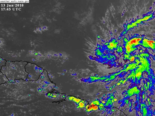
cycloneye wrote:Off topic=Look what is emerging West Africa.Are we looking at what may be Bonnie in the future? I know I am way ahead of myself,but I am posting this image to point out that already we can see why this 2010 season will be as the experts have forecasted.

Hurricane Andrew wrote:cycloneye wrote:Off topic=Look what is emerging West Africa.Are we looking at what may be Bonnie in the future? I know I am way ahead of myself,but I am posting this image to point out that already we can see why this 2010 season will be as the experts have forecasted.
The second wave looks impressive. Bonnie?
(what was the replacment name for charley? I know Ivan was Igor)


minter45 wrote:Hi all I am new to this sight and have very much enjoyed reading your insight. The link below is a intesity forcast I found for invest 92 I thought looked a little high with winds going to 80 knts in 72 hours? This is the ships forecast, any input would be appreciated.
Matt
http://www.wunderground.com/tropical/tr ... ml#a_topad

lester88 wrote:NHC says conditions are conducive for slow development. I guess we'll see who's right on this issue
 here. I had trouble getting my post screens to render, and it's only an invest! We have slow internet in the islands, lots of 'hops'. Please everyone, on "Active" forum, STAY ESSENTIAL.
cycloneye wrote:Off topic=Look what is emerging West Africa.Are we looking at what may be Bonnie in the future? I know I am way ahead of myself,but I am posting this image to point out that already we can see why this 2010 season will be as the experts have forecasted.


wxman57 wrote:Its appearance indicates it's considerably better organized now. Significant banding is evident, and I think we do have a tightening LLC. In fact, it could technically be classified as a TD already. I have seen far less organized systems called a TD in recent years. I do think that the shear over the eastern Caribbean would have a significant impact on its intensity, but if it doesn't destroy it then it could be threatening Cuba, southern Florida then reach the eastern Gulf around the 25th.
Oh, and I think there's a very good chance it'll be TD One tomorrow morning and Alex within 24-36 hrs form now.


Hurricane Andrew wrote:Just wondering, what station do you work for?


Brent wrote:TROPICAL WEATHER OUTLOOK
NWS TPC/NATIONAL HURRICANE CENTER MIAMI FL
800 PM EDT SUN JUN 13 2010
FOR THE NORTH ATLANTIC...CARIBBEAN SEA AND THE GULF OF MEXICO...
A LARGE LOW PRESSURE SYSTEM LOCATED ABOUT 975 MILES WEST-SOUTHWEST
OF THE CAPE VERDE ISLANDS IS PRODUCING WIDESPREAD CLOUDINESS ALONG
WITH SOME SHOWERS AND THUNDERSTORMS. THIS DISTURBANCE CONTINUES TO
BE WELL-ORGANIZED AND ENVIRONMENTAL CONDITIONS ARE EXPECTED TO
REMAIN CONDUCIVE FOR ADDITIONAL DEVELOPMENT OF THIS SYSTEM AS IT
MOVES WEST-NORTHWESTWARD OR NORTHWESTWARD AT 10 TO 15 MPH. THERE IS
A HIGH CHANCE...60 PERCENT...OF THIS SYSTEM BECOMING A TROPICAL
CYCLONE DURING THE NEXT 48 HOURS.
ELSEWHERE...TROPICAL CYCLONE FORMATION IS NOT EXPECTED DURING THE
NEXT 48 HOURS.
$$
FORECASTER STEWART/BLAKE
KWT wrote:Well good to see S2k back just in time for this to be made a Code Red...its cherry time!
Anyway as Wxman57 said if what some of the models are suggesting comes off then we could see this system survive or possibly regenerate down the line, esp if it can get through the shear and make it up past say 20-25N by 120-144hrs time...


Users browsing this forum: No registered users and 39 guests


