ATL : INVEST 92L - DISCUSSION
Moderator: S2k Moderators
-
Blown Away

- S2K Supporter

- Posts: 10253
- Joined: Wed May 26, 2004 6:17 am
Re: ATL : INVEST 92L
Looks like a classic CV storm in the making with a giant moisture envelope. We have seen so many firsts and broken records in the tropics over the past decade that I'm not as confident in climatology anymore, because climatology says no to 92L. 92L looks like it's gaining latitude at a pretty good rate! Amazing to see this in June.
0 likes
Hurricane Eye Experience: David 79, Irene 99, Frances 04, Jeanne 04, Wilma 05… Hurricane Brush Experience: Andrew 92, Erin 95, Floyd 99, Matthew 16, Irma 17, Ian 22, Nicole 22…


Re: ATL : INVEST 92L
Ok, I've been digging for some precedence for a June cane? I could find nothing on the furthest historical plot closest to where this storm system is....with all the waves that have poofed over the years, I believe persistence will tell us if we have Alex or not in time...but this thing looks good....which doesn't bode well for our coastlines this season...especially in the GOM....
0 likes
-
Blown Away
- S2K Supporter
- Posts: 10253
- Joined: Wed May 26, 2004 6:17 am
Re:
CrazyC83 wrote:I think we will get Alex out of this personally, but it will have to stay REALLY low to avoid shear (and bump into South America) - a reminder it is still only mid-June.
I'd say it stays at a really low latitude and hits Guyana, Suriname or French Guiana.
Climatology says low rider into SA, but some models say NE Caribbean as cane. Difficult to accept 92L becomming a cane being mid June but 2010 is being pumped as hurricane season for the record books! If 92L maintains decent model support Alex is about to enter stage right!
0 likes
Hurricane Eye Experience: David 79, Irene 99, Frances 04, Jeanne 04, Wilma 05… Hurricane Brush Experience: Andrew 92, Erin 95, Floyd 99, Matthew 16, Irma 17, Ian 22, Nicole 22…


Re: ATL : INVEST 92L
Yeah, I think this will become Alex by Monday.
0 likes
____________________________
I survived Allison, Rita, Humberto, Edouard, and Ike.
I survived Allison, Rita, Humberto, Edouard, and Ike.
-
Brent
- S2K Supporter
- Posts: 38777
- Age: 37
- Joined: Sun May 16, 2004 10:30 pm
- Location: Tulsa Oklahoma
- Contact:
Re: ATL : INVEST 92L
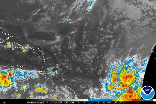
TROPICAL WEATHER OUTLOOK
NWS TPC/NATIONAL HURRICANE CENTER MIAMI FL
200 AM EDT SUN JUN 13 2010
FOR THE NORTH ATLANTIC...CARIBBEAN SEA AND THE GULF OF MEXICO...
A BROAD AREA OF LOW PRESSURE LOCATED ABOUT 800 MILES SOUTHWEST OF
THE CAPE VERDE ISLANDS CONTINUES TO SHOW SIGNS OF ORGANIZATION.
ALTHOUGH CYCLONE FORMATIONS IN THE TROPICAL ATLANTIC OCEAN ARE
QUITE RARE THIS EARLY IN THE SEASON...ENVIRONMENTAL CONDITIONS
APPEAR CONDUCIVE FOR SOME DEVELOPMENT OF THIS SYSTEM OVER THE NEXT
COUPLE OF DAYS. THERE IS A MEDIUM CHANCE...30 PERCENT...OF THIS
SYSTEM BECOMING A TROPICAL CYCLONE DURING THE NEXT 48 HOURS AS THE
LOW MOVES TOWARDS THE WEST-NORTHWEST AT 10 TO 15 MPH.
ELSEWHERE...TROPICAL CYCLONE FORMATION IS NOT EXPECTED DURING THE
NEXT 48 HOURS.
$$
FORECASTER BLAKE
0 likes
#neversummer

Re: ATL : INVEST 92L
We are at Orange. Not a surprise considering the organization trend this evening.

0 likes

Re: ATL : INVEST 92L
Wow, below 8N and East of 35W on June 13th...this is unreal. I really want to be quite skeptical but this thing looks great. This buoy should be interesting...
http://www.ndbc.noaa.gov/station_page.php?station=41026
http://www.ndbc.noaa.gov/station_page.php?station=41026
0 likes
Re: ATL : INVEST 92L
Models seem to want to start pulling this WNW and even NW. Right now looks to be due W. Let's see what happens with the continued strengthening. I think it will start gaining latitude in a few hours.
0 likes
Re: ATL : INVEST 92L
The one thing holding this back is its size. These large waves take their time to get going. If this was not so big it would be TD by now. Looks like it going to through it's second burst of convection.
0 likes

-
Kingarabian

- S2K Supporter
- Posts: 16379
- Joined: Sat Aug 08, 2009 3:06 am
- Location: Honolulu, Hawaii
Re: ATL : INVEST 92L
HURAKAN wrote:
Latest
Looks like a big SPLAT!
Edit: Hurakan, is that who I think it is in your avatar?
0 likes
RIP Kobe Bryant
-
Weatherfreak000
Re: ATL : INVEST 92L
The organization trend is continuing...I stiull don't have visibles as reference but the circulation appears to be getting tighter, the fanning of the convection is nice, and the reformation of convection further south is right here the supposed center.
I'd say we have our first 50-50% developmental chance of the 2010 hurricane season.
I'd say we have our first 50-50% developmental chance of the 2010 hurricane season.
0 likes
-
HURAKAN

- Professional-Met

- Posts: 46084
- Age: 39
- Joined: Thu May 20, 2004 4:34 pm
- Location: Key West, FL
- Contact:
Re: ATL : INVEST 92L
Kingarabian wrote:Looks like a big SPLAT!
Edit: Hurakan, is that who I think it is in your avatar?
LOL, Fergie!!
0 likes
-
Weatherfreak000
Convective pattern is getting incredibly well defined....I am gonna make a personal prediction and say the odds now confidently support 50-50% odds of development.
I was told by a meteorologist around these parts interning once that a storm will create its own environment if its large enough. It appears 92L has battled the odds and climatology all day. I expect to wake up and see a storm that is near depression status with a Code Red TWO. Unfortunately...if that is not the case...time may run out for the system.
Alot of time left though, and if the models are correct this storm may linger for days AND if NOGAPS verifies it has to be noted we are looking at a developed storm passing the Hebert Box with boiling WATER AND lessening shear.
Last edited by Weatherfreak000 on Sun Jun 13, 2010 2:28 am, edited 1 time in total.
0 likes
-
ConvergenceZone
.gif)
- Category 5

- Posts: 5241
- Joined: Fri Jul 29, 2005 1:40 am
- Location: Northern California
Wow, didn't expect to see this before going to bed. In fact, I was going to take a break from this board until about mid July, but something told me to check tonight.... 
It will be interesting to see if this does make it to TS status. Nonetheless, between this wave and the one exiting Africa, this is crazy.........
It will be interesting to see if this does make it to TS status. Nonetheless, between this wave and the one exiting Africa, this is crazy.........
0 likes
-
floridasun78
- Category 5
- Posts: 3755
- Joined: Sun May 17, 2009 10:16 pm
- Location: miami fl
Who is online
Users browsing this forum: No registered users and 49 guests