Yeah, I got some doubts about weakening. Also, at the end of the day, it was *always* gonna be about the rain that will do the destructive work +maybe storm surges on the ports on that eastern coast if it hits at the right angle.
Those very high cloudtops promise true torrents like Morakot.
Edited to remark that the omanis have apparently slashdoted some links...
ARABIAN SEA - DEEP DEPRESSION (03A)
Moderator: S2k Moderators
-
ozonepete
- Professional-Met

- Posts: 4743
- Joined: Mon Sep 07, 2009 3:23 pm
- Location: From Ozone Park, NYC / Now in Brooklyn, NY
Re: ARABIAN SEA -VERY SEVERE CYCLONIC STORM PHET (03A)
Hey guys,
I'm having trouble with photobucket so I can't post images yet, but here's a few points:
GFS definitely had it right up to now - it's been going much more NW than the other models like ECMWF had.
It sure looks like it's weakening now. As a lot of you said, it just has to be ingesting dry air from the west into its middle levels, where it hurts the most.
In the last few frames it looks like it's either stalling or moving southwest. I think that mid-level/upper trough is coming in rapidly now and exerting its influence. Maybe PHET will even loop.
0 likes

-
HURAKAN

- Professional-Met
- Posts: 46084
- Age: 39
- Joined: Thu May 20, 2004 4:34 pm
- Location: Key West, FL
- Contact:
Re: ARABIAN SEA -VERY SEVERE CYCLONIC STORM PHET (03A)
UW - CIMSS
ADVANCED DVORAK TECHNIQUE
ADT-Version 8.1.1
Tropical Cyclone Intensity Algorithm
----- Current Analysis -----
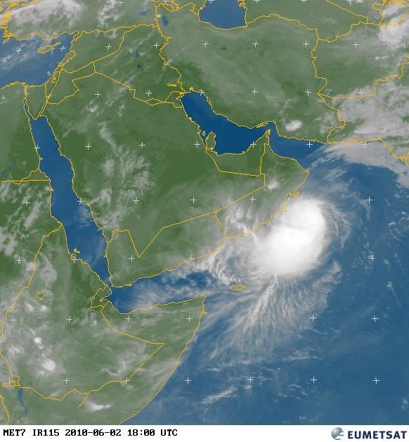
Date : 02 JUN 2010 Time : 180000 UTC
Lat : 18:26:45 N Lon : 59:39:34 E
CI# /Pressure/ Vmax
6.0 / 927.0mb/115.0kt
Final T# Adj T# Raw T#
5.5 5.3 4.8
Latitude bias adjustment to MSLP : +0.0mb
Center Temp : -77.6C Cloud Region Temp : -79.1C
Scene Type : UNIFORM CDO CLOUD REGION
Positioning Method : SPIRAL ANALYSIS
Ocean Basin : INDIAN
Dvorak CI > MSLP Conversion Used : PACIFIC
Tno/CI Rules : Constraint Limits : 0.7T/6hr
Weakening Flag : ON
Rapid Dissipation Flag : FLAG
ADVANCED DVORAK TECHNIQUE
ADT-Version 8.1.1
Tropical Cyclone Intensity Algorithm
----- Current Analysis -----
Date : 02 JUN 2010 Time : 180000 UTC
Lat : 18:26:45 N Lon : 59:39:34 E
CI# /Pressure/ Vmax
6.0 / 927.0mb/115.0kt
Final T# Adj T# Raw T#
5.5 5.3 4.8
Latitude bias adjustment to MSLP : +0.0mb
Center Temp : -77.6C Cloud Region Temp : -79.1C
Scene Type : UNIFORM CDO CLOUD REGION
Positioning Method : SPIRAL ANALYSIS
Ocean Basin : INDIAN
Dvorak CI > MSLP Conversion Used : PACIFIC
Tno/CI Rules : Constraint Limits : 0.7T/6hr
Weakening Flag : ON
Rapid Dissipation Flag : FLAG
0 likes

-
Grifforzer
- Category 1

- Posts: 418
- Joined: Thu Feb 26, 2009 11:27 pm
Their website is overloaded with traffic and is currently unavailable.
FKIN20 VIDP 021630
TC ADVISORY
DTG: 20100602/1200Z
TCAC: NEW DELHI
TC: PHET
NR: 6
PSN: N1800 E06030
MOV: NW 6 KT
C: 970 HPA
MAX WIND: 80KT
FCST PSN+6HR: 02/1800Z N1830 E06000
FCST MAX WIND+6HR: 85 KT
FCST PSN+12HR: 02/0000Z N1900 E05930
FCST MAX WIND+12HR: 90 KT
FCST PSN+18HR: 02/0600Z N1930 E05900
FCST MAX WIND+18HR: 95 KT
FCST PSN+24HR: 03/1200Z N2000 E05900
FCST MAX WIND+24HR: 100 KT
NEXT MSG: 20100602/1800Z
---
This is all we have now from the India Meteorological Department for now until their website works again.
Last edited by Grifforzer on Wed Jun 02, 2010 2:09 pm, edited 1 time in total.
0 likes
-
brunota2003

- S2K Supporter

- Posts: 9476
- Age: 35
- Joined: Sat Jul 30, 2005 9:56 pm
- Location: Stanton, KY...formerly Havelock, NC
- Contact:
-
ozonepete
- Professional-Met
- Posts: 4743
- Joined: Mon Sep 07, 2009 3:23 pm
- Location: From Ozone Park, NYC / Now in Brooklyn, NY
Re:
Grifforzer wrote:Their website is overloaded with traffic and is currently unavailable.
Yes, that's gotta be what it is. They must be getting bombarded with traffic and are still not equipped to handle this. It's a shame.
0 likes


Remember what quite a few Hurricanes do when they come close to the Gulf Coast, something similar will happen this time with Phet.
I think the dry air from Oman was always going to be a big issue for Phet, I think the western side really is being destroyed by that stable dry air coming off land, however the inflow is still superb and the system is dragging in some very unstable air with it developing a big convective tail.
I think the dry air from Oman was always going to be a big issue for Phet, I think the western side really is being destroyed by that stable dry air coming off land, however the inflow is still superb and the system is dragging in some very unstable air with it developing a big convective tail.
0 likes
Personal Forecast Disclaimer:
The posts in this forum are NOT official forecast and should not be used as such. They are just the opinion of the poster and may or may not be backed by sound meteorological data. They are NOT endorsed by any professional institution or storm2k.org. For official information, please refer to the NHC and NWS products
The posts in this forum are NOT official forecast and should not be used as such. They are just the opinion of the poster and may or may not be backed by sound meteorological data. They are NOT endorsed by any professional institution or storm2k.org. For official information, please refer to the NHC and NWS products

Yep, even if this weakens quite rapidly your still going to see a fairly strong system make landfall in an area that isn't used to it really.
0 likes
Personal Forecast Disclaimer:
The posts in this forum are NOT official forecast and should not be used as such. They are just the opinion of the poster and may or may not be backed by sound meteorological data. They are NOT endorsed by any professional institution or storm2k.org. For official information, please refer to the NHC and NWS products
The posts in this forum are NOT official forecast and should not be used as such. They are just the opinion of the poster and may or may not be backed by sound meteorological data. They are NOT endorsed by any professional institution or storm2k.org. For official information, please refer to the NHC and NWS products

-
P.K.

- Professional-Met
- Posts: 5149
- Joined: Thu Sep 23, 2004 5:57 pm
- Location: Watford, England
- Contact:
Re: ARABIAN SEA -VERY SEVERE CYCLONIC STORM PHET (03A)
FKIN20 VIDP 022030
TC ADVISORY
DTG: 20100602/1800Z
TCAC: NEW DELHI
TC: PHET
NR: 7
PSN: N1830 E06000
MOV: NW 6 KT
C: 970 HPA
MAX WIND: 80KT
FCST PSN+6HR: 02/0000Z N1900 E05930
FCST MAX WIND+6HR: 85 KT
FCST PSN+12HR: 02/0600Z N1930 E05900
FCST MAX WIND+12HR: 90 KT
FCST PSN+18HR: 03/1200Z N2000 E05900
FCST MAX WIND+18HR: 95 KT
FCST PSN+24HR: 03/1800Z N2030 E05900
FCST MAX WIND+24HR: 100 KT
NEXT MSG: 20100603/0000Z
0 likes


Who is online
Users browsing this forum: No registered users and 184 guests