Phoenix's Song wrote:cycloneye wrote:18z Best Track
Looks like an upgrade very soon.
EP, 90, 2010052818, , BEST, 0, 128N, 945W, 30, 1005 , LO
Where is the link to the BT?
ftp://ftp.tpc.ncep.noaa.gov/atcf/tcweb/
Moderator: S2k Moderators


Phoenix's Song wrote:cycloneye wrote:18z Best Track
Looks like an upgrade very soon.
EP, 90, 2010052818, , BEST, 0, 128N, 945W, 30, 1005 , LO
Where is the link to the BT?
cycloneye wrote:Phoenix's Song wrote:cycloneye wrote:18z Best Track
Looks like an upgrade very soon.
EP, 90, 2010052818, , BEST, 0, 128N, 945W, 30, 1005 , LO
Where is the link to the BT?
ftp://ftp.tpc.ncep.noaa.gov/atcf/tcweb/


I-wall wrote:Does anyone know when or if we will get any quickscat images or microwave images of this system?
srainhoutx wrote:I-wall wrote:Does anyone know when or if we will get any quickscat images or microwave images of this system?
QuickSCAT failed several months ago.
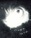

I-wall wrote:srainhoutx wrote:I-wall wrote:Does anyone know when or if we will get any quickscat images or microwave images of this system?
QuickSCAT failed several months ago.
How much does that affect the NHC's ability to determine if a system is organized enough to be classified as a depression? How else can you tell if a system has a closed circulation if the center is covered by clouds?


Users browsing this forum: No registered users and 45 guests