EPAC : EX TROPICAL DEPRESSION AGATHA

Moderator: S2k Moderators

Message
Author
User avatar
KWT
Category 5
Category 5
Posts: 31415
Joined: Tue Aug 17, 2004 11:02 am
Location: UK!!!

Re: EPAC : INVEST 90E

#141 Postby KWT » Fri May 28, 2010 12:14 pm

CourierPR wrote:Regardless of development of this system, I think we will see a piece of energy in the Western Caribbean that will need to be watched.


Without a doubt it will need to be watched but no models are really suggesting anything developing anymore any energy leftover, I suspect thats probably because the models are only making 90E a weak system and thus a weak system will probably be snuffed out by CA, esp if it takes the longer landmass track.
0 likes   
Personal Forecast Disclaimer:
The posts in this forum are NOT official forecast and should not be used as such. They are just the opinion of the poster and may or may not be backed by sound meteorological data. They are NOT endorsed by any professional institution or storm2k.org. For official information, please refer to the NHC and NWS products

User avatar
CourierPR
Category 5
Category 5
Posts: 1335
Age: 71
Joined: Tue Aug 31, 2004 7:53 pm
Location: Pompano Beach, Florida

Re: EPAC : INVEST 90E

#142 Postby CourierPR » Fri May 28, 2010 12:38 pm

The system appears to be getting better organized on the latest satellite loop.
0 likes   

User avatar
cycloneye
Admin
Admin
Posts: 145295
Age: 68
Joined: Thu Oct 10, 2002 10:54 am
Location: San Juan, Puerto Rico

Re: EPAC : INVEST 90E

#143 Postby cycloneye » Fri May 28, 2010 12:41 pm

TD later today or Saturday

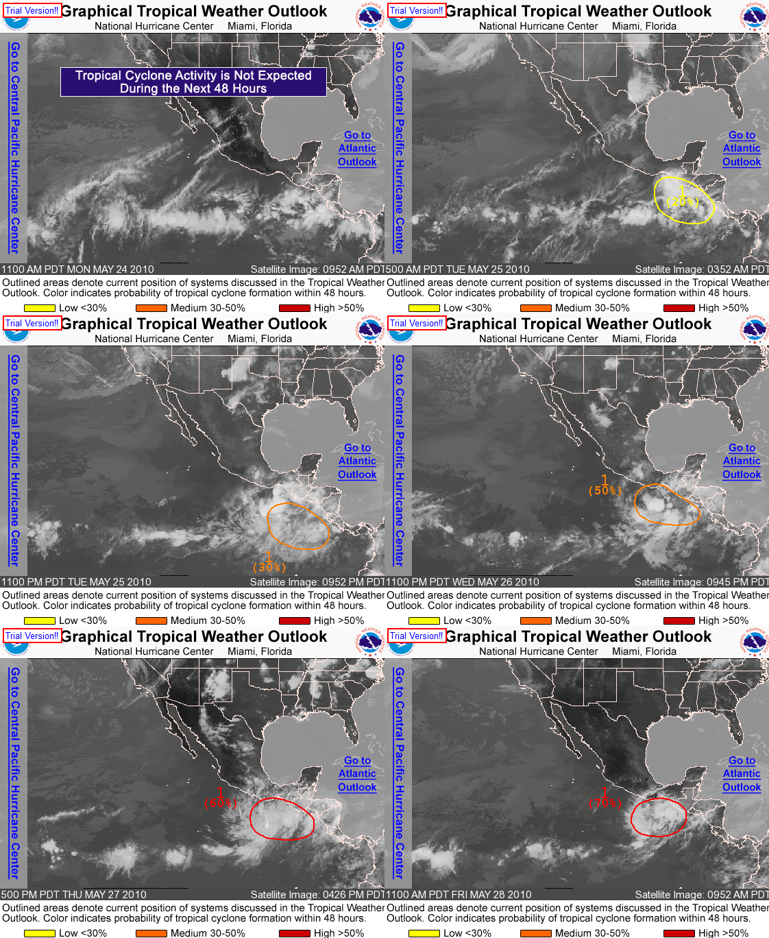
TROPICAL WEATHER OUTLOOK
NWS TPC/NATIONAL HURRICANE CENTER MIAMI FL
1100 AM PDT FRI MAY 28 2010

FOR THE EASTERN NORTH PACIFIC...EAST OF 140 DEGREES WEST LONGITUDE..

SATELLITE IMAGES INDICATE THAT THE BROAD AREA OF LOW PRESSURE
LOCATED A COUPLE HUNDRED MILES SOUTH OF THE GULF OF TEHUANTEPEC IS
GRADUALLY BECOMING BETTER ORGANIZED. ONSHORE WINDS TO THE EAST OF
THE DISTURBANCE CONTINUE TO PRODUCE LOCALLY HEAVY RAINS FROM EL
SALVADOR WESTWARD ALONG THE PACIFIC COAST TO NEAR THE GULF OF
TEHUANTEPEC. THESE RAINS COULD CAUSE LIFE-THREATENING FLASH FLOODS
AND MUD SLIDES IN THESE AREAS OVER THE NEXT COUPLE OF DAYS.
ENVIRONMENTAL CONDITIONS ARE FAVORABLE FOR FURTHER DEVELOPMENT...
AND A TROPICAL DEPRESSION COULD FORM LATER TODAY OR SATURDAY AS IT
DRIFTS NORTHEASTWARD. THERE IS A HIGH CHANCE...70 PERCENT...OF THIS
SYSTEM BECOMING A TROPICAL CYCLONE DURING THE NEXT 48 HOURS.

ELSEWHERE...TROPICAL CYCLONE FORMATION IS NOT EXPECTED DURING THE
NEXT 48 HOURS.

$$
FORECASTER BROWN/STEWART

0 likes   
Visit the Caribbean-Central America Weather Thread where you can find at first post web cams,radars
and observations from Caribbean basin members Click Here

User avatar
KWT
Category 5
Category 5
Posts: 31415
Joined: Tue Aug 17, 2004 11:02 am
Location: UK!!!

#144 Postby KWT » Fri May 28, 2010 12:50 pm

Yeah it does look like its getting there, it may take one more cycle of convective bursting but I think its slowly but surely getting there.
0 likes   
Personal Forecast Disclaimer:
The posts in this forum are NOT official forecast and should not be used as such. They are just the opinion of the poster and may or may not be backed by sound meteorological data. They are NOT endorsed by any professional institution or storm2k.org. For official information, please refer to the NHC and NWS products

clfenwi
Category 5
Category 5
Posts: 3331
Joined: Thu Jun 09, 2005 12:54 pm

Re: EPAC : INVEST 90E

#145 Postby clfenwi » Fri May 28, 2010 12:59 pm

12Z GFDL shows some consistency compared to the 00Z. It brings the low to the Mexico/Guatemala coast on Saturday night as a Tropical Storm (and drops the vortex over Guatemala).

12Z HWRF more or less maintains its idea of a tropical storm forming, then dissapting off-shore.

Nothing significant to report from GFS or NOGAPS.

Excitable types should not look at the 12Z Canadian.
0 likes   

User avatar
CourierPR
Category 5
Category 5
Posts: 1335
Age: 71
Joined: Tue Aug 31, 2004 7:53 pm
Location: Pompano Beach, Florida

Re: EPAC : INVEST 90E

#146 Postby CourierPR » Fri May 28, 2010 1:04 pm

That 12Z Canadian run is interesting, to say the least.
0 likes   

clfenwi
Category 5
Category 5
Posts: 3331
Joined: Thu Jun 09, 2005 12:54 pm

Re: EPAC : INVEST 90E

#147 Postby clfenwi » Fri May 28, 2010 1:09 pm

Now the UKMET not only analyzes a tropical storm, but it analayzes a moderate one at that. Dissipates the storm over El Salvador/Guatemala.

WTNT80 EGRR 281800


MET OFFICE TROPICAL CYCLONE GUIDANCE FOR NORTH-EAST PACIFIC

AND ATLANTIC

GLOBAL MODEL DATA TIME 12UTC 28.05.2010

TROPICAL STORM DEVELOPED IN THE MODEL ANALYSIS AT POSITION :
12.1N 94.8W

VERIFYING TIME POSITION STRENGTH TENDENCY
-------------- -------- -------- --------
12UTC 28.05.2010 12.1N 94.8W MODERATE
00UTC 29.05.2010 12.8N 94.4W MODERATE LITTLE CHANGE
12UTC 29.05.2010 13.2N 93.7W MODERATE INTENSIFYING SLIGHTLY
00UTC 30.05.2010 13.5N 92.6W STRONG INTENSIFYING RAPIDLY
12UTC 30.05.2010 13.5N 90.6W MODERATE WEAKENING SLIGHTLY
00UTC 31.05.2010 14.6N 90.7W WEAK WEAKENING RAPIDLY
12UTC 31.05.2010 BELOW TROPICAL STORM STRENGTH


THIS INFORMATION IS PROVIDED AS GUIDANCE FOR TROPICAL CYCLONE
RSMCS. IT REQUIRES INTERPRETATION BY TROPICAL CYCLONE SPECIALISTS
AND SHOULD NOT BE CONSIDERED AS A FINAL PRODUCT


MET OFFICE, EXETER, UK

TOO 281643
0 likes   

User avatar
cycloneye
Admin
Admin
Posts: 145295
Age: 68
Joined: Thu Oct 10, 2002 10:54 am
Location: San Juan, Puerto Rico

Re: EPAC : INVEST 90E

#148 Postby cycloneye » Fri May 28, 2010 1:19 pm

SSD Dvorak T Number

Going up this afternoon.

http://www.ssd.noaa.gov/PS/TROP/tdpositions.html

28/1745 UTC 13.4N 94.7W T1.5/1.5 90E -- East Pacific
0 likes   
Visit the Caribbean-Central America Weather Thread where you can find at first post web cams,radars
and observations from Caribbean basin members Click Here

User avatar
HURAKAN
Professional-Met
Professional-Met
Posts: 46086
Age: 38
Joined: Thu May 20, 2004 4:34 pm
Location: Key West, FL
Contact:

Re: EPAC : INVEST 90E

#149 Postby HURAKAN » Fri May 28, 2010 1:22 pm

Image

Latest
0 likes   

User avatar
somethingfunny
ChatStaff
ChatStaff
Posts: 3926
Age: 37
Joined: Thu May 31, 2007 10:30 pm
Location: McKinney, Texas

Re: EPAC : INVEST 90E

#150 Postby somethingfunny » Fri May 28, 2010 1:28 pm

Category 5 wrote:For the record, last crossover was Alma/Arthur in 08.


Sort of... according to the Wiki page, Alma dissipated over Central America, and the remnants combined with two other tropical waves to form Arthur. It wasn't simply a case of one storm crossing over and continuing on the other side.

http://en.wikipedia.org/wiki/List_of_At ... hurricanes

I also don't think the models have a particularly firm grasp of land interactions, especially given the topograhy of Central America. Alot of it will depend on where, how fast, and at what angle 90E/"Agatha" (not named yet) crosses, but the deck is stacked against a successful crossover historically.

Even so, we don't need any sort of tropical weathermaker moving into the Gulf of Mexico any time soon, even if it isn't organized weather. I don't think there's any doubt that SOMETHING will be in the GOM by sometime next week. It will probably be of the disorganized blob variety.

The posts in this forum are NOT official forecast and should not be used as such. They are just the opinion of the poster and may or may not be backed by sound meteorological data. They are NOT endorsed by any professional institution or storm2k.org. For official information, please refer to the NHC and NWS products.
0 likes   

User avatar
cycloneye
Admin
Admin
Posts: 145295
Age: 68
Joined: Thu Oct 10, 2002 10:54 am
Location: San Juan, Puerto Rico

Re: EPAC : INVEST 90E

#151 Postby cycloneye » Fri May 28, 2010 2:03 pm

18z Best Track

Looks like an upgrade very soon.

EP, 90, 2010052818, , BEST, 0, 128N, 945W, 30, 1005 , LO
0 likes   
Visit the Caribbean-Central America Weather Thread where you can find at first post web cams,radars
and observations from Caribbean basin members Click Here

CrazyC83
Professional-Met
Professional-Met
Posts: 34002
Joined: Tue Mar 07, 2006 11:57 pm
Location: Deep South, for the first time!

#152 Postby CrazyC83 » Fri May 28, 2010 2:12 pm

Alma did not directly become Arthur though as Alma dissipated and the remnant low reformed.

If this were to become Agatha and enter the Atlantic while still a TD or higher, it remains Agatha.
0 likes   

User avatar
Macrocane
Category 5
Category 5
Posts: 4218
Age: 36
Joined: Sun May 24, 2009 5:35 pm
Location: El Salvador

Re: EPAC : INVEST 90E

#153 Postby Macrocane » Fri May 28, 2010 2:17 pm

The Euro is on board again developing this system before making landfall in Central America:

Euro 24 hours
0 likes   

User avatar
KWT
Category 5
Category 5
Posts: 31415
Joined: Tue Aug 17, 2004 11:02 am
Location: UK!!!

#154 Postby KWT » Fri May 28, 2010 2:49 pm

Structure looks good though the convection is yet again on the wane, but I suspect that will be a short lived thing and the next time it increases again we will probably see the NHC pull the trigger.

Models in good agreement on a weak system developing, possibly weak TS getting towards 40-45kts before landfall.
0 likes   
Personal Forecast Disclaimer:
The posts in this forum are NOT official forecast and should not be used as such. They are just the opinion of the poster and may or may not be backed by sound meteorological data. They are NOT endorsed by any professional institution or storm2k.org. For official information, please refer to the NHC and NWS products

User avatar
HURAKAN
Professional-Met
Professional-Met
Posts: 46086
Age: 38
Joined: Thu May 20, 2004 4:34 pm
Location: Key West, FL
Contact:

#155 Postby HURAKAN » Fri May 28, 2010 3:03 pm

Image

Latest
0 likes   

User avatar
cycloneye
Admin
Admin
Posts: 145295
Age: 68
Joined: Thu Oct 10, 2002 10:54 am
Location: San Juan, Puerto Rico

Re: EPAC : INVEST 90E

#156 Postby cycloneye » Fri May 28, 2010 3:05 pm

IMO,the proximity to land will not let it develop past TD status.
0 likes   
Visit the Caribbean-Central America Weather Thread where you can find at first post web cams,radars
and observations from Caribbean basin members Click Here

User avatar
KWT
Category 5
Category 5
Posts: 31415
Joined: Tue Aug 17, 2004 11:02 am
Location: UK!!!

#157 Postby KWT » Fri May 28, 2010 3:06 pm

Its probably been a tropical depression for a little while now but I think the NHC have been put off by the constant waxing and waning of the convection.
0 likes   
Personal Forecast Disclaimer:
The posts in this forum are NOT official forecast and should not be used as such. They are just the opinion of the poster and may or may not be backed by sound meteorological data. They are NOT endorsed by any professional institution or storm2k.org. For official information, please refer to the NHC and NWS products

User avatar
Iune
Category 1
Category 1
Posts: 291
Joined: Mon Aug 04, 2008 12:23 pm
Location: New York City

Re: EPAC : INVEST 90E

#158 Postby Iune » Fri May 28, 2010 3:18 pm

Image of the progression of TWO's for the storm as of May 28 11 a.m.

Image
0 likes   
Floyd 1999 · Irene 2011 · Sandy 2012

User avatar
lester
S2K Supporter
S2K Supporter
Posts: 1305
Age: 36
Joined: Sat Aug 27, 2005 5:21 pm
Location: Washington, DC
Contact:

Re: EPAC : INVEST 90E

#159 Postby lester » Fri May 28, 2010 3:55 pm

Phoenix's Song wrote:Image of the progression of TWO's for the storm as of May 28 11 a.m.

Image


^^

wow good job! :cheesy:
0 likes   

User avatar
Iune
Category 1
Category 1
Posts: 291
Joined: Mon Aug 04, 2008 12:23 pm
Location: New York City

Re: EPAC : INVEST 90E

#160 Postby Iune » Fri May 28, 2010 4:20 pm

cycloneye wrote:18z Best Track

Looks like an upgrade very soon.

EP, 90, 2010052818, , BEST, 0, 128N, 945W, 30, 1005 , LO


Where is the link to the BT?
0 likes   
Floyd 1999 · Irene 2011 · Sandy 2012


Return to “2010”

Who is online

Users browsing this forum: No registered users and 4 guests