ATL : INVEST 90L

Moderator: S2k Moderators

Message
Author
User avatar
HURAKAN
Professional-Met
Professional-Met
Posts: 46086
Age: 38
Joined: Thu May 20, 2004 4:34 pm
Location: Key West, FL
Contact:

#321 Postby HURAKAN » Wed May 26, 2010 1:46 pm

Image

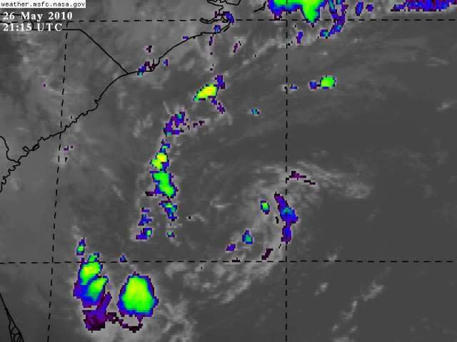
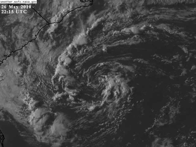
Latest ... not much time, it was a nice practice run!!
0 likes   

User avatar
HURAKAN
Professional-Met
Professional-Met
Posts: 46086
Age: 38
Joined: Thu May 20, 2004 4:34 pm
Location: Key West, FL
Contact:

#322 Postby HURAKAN » Wed May 26, 2010 1:51 pm

Image

Close look at the center
0 likes   

User avatar
KWT
Category 5
Category 5
Posts: 31415
Joined: Tue Aug 17, 2004 11:02 am
Location: UK!!!

#323 Postby KWT » Wed May 26, 2010 2:26 pm

Looks very bare now, pretty much just a naked LLC right now which shows that the systems chances of developing is, as wxman57 said, pretty much approaching zero now. Still as Hurakan also said it was a nice little test run for the real fun and games and overall the models have done fairly well with calling for the lows development.

Still a nice looking circulation for sure!
0 likes   
Personal Forecast Disclaimer:
The posts in this forum are NOT official forecast and should not be used as such. They are just the opinion of the poster and may or may not be backed by sound meteorological data. They are NOT endorsed by any professional institution or storm2k.org. For official information, please refer to the NHC and NWS products

User avatar
HURAKAN
Professional-Met
Professional-Met
Posts: 46086
Age: 38
Joined: Thu May 20, 2004 4:34 pm
Location: Key West, FL
Contact:

#324 Postby HURAKAN » Wed May 26, 2010 2:29 pm

Image

Loop
0 likes   

User avatar
KWT
Category 5
Category 5
Posts: 31415
Joined: Tue Aug 17, 2004 11:02 am
Location: UK!!!

#325 Postby KWT » Wed May 26, 2010 2:49 pm

Looks like the system has started to be ejected back ENE as the upper level trough starts to move eastwards as well.
0 likes   
Personal Forecast Disclaimer:
The posts in this forum are NOT official forecast and should not be used as such. They are just the opinion of the poster and may or may not be backed by sound meteorological data. They are NOT endorsed by any professional institution or storm2k.org. For official information, please refer to the NHC and NWS products

User avatar
HURAKAN
Professional-Met
Professional-Met
Posts: 46086
Age: 38
Joined: Thu May 20, 2004 4:34 pm
Location: Key West, FL
Contact:

#326 Postby HURAKAN » Wed May 26, 2010 3:24 pm

Image

It's funny how one disturbance has what the other needs. If we combine 90L and 90E, we would have a depression or storm by now!!
0 likes   

xironman
S2K Supporter
S2K Supporter
Posts: 2522
Joined: Sun Jun 10, 2007 4:53 pm
Location: NoVA

Re: ATL : INVEST 90L

#327 Postby xironman » Wed May 26, 2010 3:27 pm

Sometimes they look like they are totally dead then there is a burst as they eject to the NE like TD1 last year
Image
Image
0 likes   

User avatar
HURAKAN
Professional-Met
Professional-Met
Posts: 46086
Age: 38
Joined: Thu May 20, 2004 4:34 pm
Location: Key West, FL
Contact:

#328 Postby HURAKAN » Wed May 26, 2010 3:34 pm

xironman, believe it or not, I was looking at the same image a few minutes ago but didn't want to post it because I'm always the one making comparisons!!! lol

But yes, I agree. Maybe we see some baroclinic enhancement and convection can fire near the center as it's being driven to the northeast.
0 likes   

JonathanBelles
Professional-Met
Professional-Met
Posts: 11430
Age: 35
Joined: Sat Dec 24, 2005 9:00 pm
Location: School: Florida State University (Tallahassee, FL) Home: St. Petersburg, Florida
Contact:

#329 Postby JonathanBelles » Wed May 26, 2010 3:51 pm

Right now 90L is purely extratopical and is making its way back out to sea. For this reason, I am not going to do a forecast for it. After 90L makes it past the island of Bermuda, which will likely occur tomorrow night. Just looking at the latest models, and there has been quite a big swing in forecast track. GFS, NOGAPS, and NAM as well as a few others now have yet another surprise in store. These models bring 90L back to the west for the weekend. I've been doing other things today in life that require attention, so I haven't been able to look at the models any more in depth than this. If anyone has, please send me some insights.


The posts in this forum are NOT official forecast and should not be used as such. They are just the opinion of the poster and may or may not be backed by sound meteorological data. They are NOT endorsed by any professional institution or storm2k.org. For official information, please refer to the NHC and NWS products.
0 likes   

User avatar
HURAKAN
Professional-Met
Professional-Met
Posts: 46086
Age: 38
Joined: Thu May 20, 2004 4:34 pm
Location: Key West, FL
Contact:

#330 Postby HURAKAN » Wed May 26, 2010 3:54 pm

Image

Image

Interesting, thanks 789 for pointing that out!
0 likes   

User avatar
KWT
Category 5
Category 5
Posts: 31415
Joined: Tue Aug 17, 2004 11:02 am
Location: UK!!!

#331 Postby KWT » Wed May 26, 2010 4:09 pm

Ah thats very interesting it has to be said, certainly is just extra tropical right now but if it doesn't quite get taken out to sea by the upper trough then a bend back is quite possible.

That being said I'd expect the upper trough to be just enough to shunt the system out to sea, in which case nothingis going to happen, if it gets back west then you can't rule it out but even then I'd be doubtful of anything happening.

Still that would sure be a twist to this system, can't totally rule it out if it doesn't manage to get far enough to the east. Not a bad system to get back into the swing of things really is it!
0 likes   
Personal Forecast Disclaimer:
The posts in this forum are NOT official forecast and should not be used as such. They are just the opinion of the poster and may or may not be backed by sound meteorological data. They are NOT endorsed by any professional institution or storm2k.org. For official information, please refer to the NHC and NWS products

User avatar
HURAKAN
Professional-Met
Professional-Met
Posts: 46086
Age: 38
Joined: Thu May 20, 2004 4:34 pm
Location: Key West, FL
Contact:

#332 Postby HURAKAN » Wed May 26, 2010 4:38 pm

Image

Consensus ... that's a shift
0 likes   

User avatar
HURAKAN
Professional-Met
Professional-Met
Posts: 46086
Age: 38
Joined: Thu May 20, 2004 4:34 pm
Location: Key West, FL
Contact:

#333 Postby HURAKAN » Wed May 26, 2010 5:09 pm

Image

poor 90L
0 likes   

User avatar
HURAKAN
Professional-Met
Professional-Met
Posts: 46086
Age: 38
Joined: Thu May 20, 2004 4:34 pm
Location: Key West, FL
Contact:

#334 Postby HURAKAN » Wed May 26, 2010 5:34 pm

Image

Latest
0 likes   

jaxfladude
Category 5
Category 5
Posts: 1249
Joined: Wed Aug 24, 2005 9:36 pm
Location: Jacksonville, Fla

#335 Postby jaxfladude » Wed May 26, 2010 6:11 pm

We've got a fighter here(maybe) :eek:
0 likes   

User avatar
AJC3
Admin
Admin
Posts: 3999
Age: 61
Joined: Tue Aug 31, 2004 7:04 pm
Location: Ballston Spa, New York
Contact:

Re: ATL : INVEST 90L

#336 Postby AJC3 » Wed May 26, 2010 6:42 pm

90L isn't long for this world. The upper low/trough over the top of it is forecast to shear out over the next few days, leaving a pattern where there is increasing surface to 850 MB easterlies, due to a building low level ridge to the north, and increasing mid to upper level westerlies. not only will the shear pattern become even less conducive, but the thermodynamic pattern will as well. The mid level cold pool associated with the 500 MB low was the thing responsible for keeping temperature lapse rates steep enough the meager toots of convection that fired to do so. With the mid/upper trough shearing out, 500 MB temps will warm, and therefore those 74-76F water temps won't be warm enough to sustain the needed instability.

All-in-all, what you have is poor to marginal-at-best conditions that will only get worse. I foresee DeForest Kelly making an appearance in the not too distant future.
0 likes   

User avatar
gatorcane
S2K Supporter
S2K Supporter
Posts: 23691
Age: 47
Joined: Sun Mar 13, 2005 3:54 pm
Location: Boca Raton, FL

Re: ATL : INVEST 90L

#337 Postby gatorcane » Wed May 26, 2010 8:48 pm

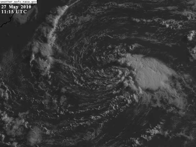
wxman57 wrote:Chances of it getting named are approaching zero now. Bones is approaching the microphone.


I never gave it much of a chance from the get-go. Too many negatives going against it. Bring out BONES is all I have to say.

The EPAC system looks much more impressive, though it is quite close to land. It does seem to have a much better shot than 90L.
0 likes   

User avatar
HURAKAN
Professional-Met
Professional-Met
Posts: 46086
Age: 38
Joined: Thu May 20, 2004 4:34 pm
Location: Key West, FL
Contact:

#338 Postby HURAKAN » Wed May 26, 2010 9:33 pm

AL, 90, 2010052700, , BEST, 0, 310N, 759W, 25, 1007, LO

riding into the sunset
0 likes   

User avatar
HURAKAN
Professional-Met
Professional-Met
Posts: 46086
Age: 38
Joined: Thu May 20, 2004 4:34 pm
Location: Key West, FL
Contact:

#339 Postby HURAKAN » Thu May 27, 2010 6:30 am

Image

Still there!
0 likes   

User avatar
KWT
Category 5
Category 5
Posts: 31415
Joined: Tue Aug 17, 2004 11:02 am
Location: UK!!!

#340 Postby KWT » Thu May 27, 2010 6:40 am

Looking quite elongated though, that being said the convection currently to the east of the center could end up giving it just a little more time. The system really can't afford to get any further east because SST's only further decrease which will limit lapse rates even further.
0 likes   
Personal Forecast Disclaimer:
The posts in this forum are NOT official forecast and should not be used as such. They are just the opinion of the poster and may or may not be backed by sound meteorological data. They are NOT endorsed by any professional institution or storm2k.org. For official information, please refer to the NHC and NWS products


Return to “2010”

Who is online

Users browsing this forum: No registered users and 3 guests