ATL : INVEST 90L

Moderator: S2k Moderators

Message
Author
User avatar
HURAKAN
Professional-Met
Professional-Met
Posts: 46086
Age: 38
Joined: Thu May 20, 2004 4:34 pm
Location: Key West, FL
Contact:

Re: ATL : INVEST 90L=CODE YELLOW

#281 Postby HURAKAN » Tue May 25, 2010 9:52 am

Shear:

Image

Upper Divergence:

Image

Lower Convergence:

Image
0 likes   

User avatar
srainhoutx
S2K Supporter
S2K Supporter
Posts: 6919
Age: 67
Joined: Sun Jan 14, 2007 11:34 am
Location: Haywood County, NC
Contact:

Re: ATL : INVEST 90L

#282 Postby srainhoutx » Tue May 25, 2010 11:05 am

000
ABNT20 KNHC 251558
TWOAT
SPECIAL TROPICAL WEATHER OUTLOOK
NWS TPC/NATIONAL HURRICANE CENTER MIAMI FL
1200 PM EDT TUE MAY 25 2010

FOR THE NORTH ATLANTIC...CARIBBEAN SEA AND THE GULF OF MEXICO...

THE NON-TROPICAL LOW PRESSURE SYSTEM LOCATED ABOUT 450 MILES
SOUTHEAST OF THE NORTH CAROLINA COAST REMAINS DISORGANIZED...AND
THE POTENTIAL FOR THIS SYSTEM TO ACQUIRE SUBTROPICAL
CHARACTERISTICS CONTINUES TO DIMINISH
.
THERE IS A LOW CHANCE...10
PERCENT...OF THIS SYSTEM BECOMING A SUBTROPICAL CYCLONE DURING THE
NEXT 48 HOURS. THE LOW IS DRIFTING GENERALLY NORTH-NORTHWESTWARD
AND A TURN TOWARD THE NORTHEAST IS EXPECTED OVER THE NEXT COUPLE OF
DAYS. THIS SYSTEM CONTINUES TO PRODUCE A LARGE AREA OF
SHOWERS...THUNDERSTORMS...AND GALE FORCE WINDS. FOR ADDITIONAL
INFORMATION...PLEASE SEE HIGH SEAS FORECASTS ISSUED BY THE NATIONAL
WEATHER SERVICE...UNDER AWIPS HEADER NFDHSFAT1 AND WMO HEADER
FZNT01 KWBC...AND STATEMENTS FROM LOCAL NATIONAL WEATHER SERVICE
FORECAST OFFICES. NO ADDITIONAL SPECIAL TROPICAL WEATHER OUTLOOKS
ON THIS SYSTEM ARE ANTICIPATED.

$$
FORECASTER PASCH/ROBERTS
0 likes   
Carla/Alicia/Jerry(In The Eye)/Michelle/Charley/Ivan/Dennis/Katrina/Rita/Wilma/Ike/Harvey

Member: National Weather Association
Wx Infinity Forums
http://wxinfinity.com/index.php

Facebook.com/WeatherInfinity
Twitter @WeatherInfinity

User avatar
KWT
Category 5
Category 5
Posts: 31415
Joined: Tue Aug 17, 2004 11:02 am
Location: UK!!!

#283 Postby KWT » Tue May 25, 2010 11:16 am

Whilst I suppose you still can't rule out a subtropical system with this system convection is still well displaced and is going to have to get closer if we are to get this upgraded to a subtropical storm, conditioons aloft do appear better though convergence is a big issue, given there is a real lack of it right now near the center of the system.
0 likes   
Personal Forecast Disclaimer:
The posts in this forum are NOT official forecast and should not be used as such. They are just the opinion of the poster and may or may not be backed by sound meteorological data. They are NOT endorsed by any professional institution or storm2k.org. For official information, please refer to the NHC and NWS products

User avatar
cycloneye
Admin
Admin
Posts: 145277
Age: 68
Joined: Thu Oct 10, 2002 10:54 am
Location: San Juan, Puerto Rico

Re: ATL : INVEST 90L

#284 Postby cycloneye » Tue May 25, 2010 1:39 pm

18 UTC Best Track

AL, 90, 2010052518, , BEST, 0, 308N, 725W, 40, 1005, LO
0 likes   
Visit the Caribbean-Central America Weather Thread where you can find at first post web cams,radars
and observations from Caribbean basin members Click Here

User avatar
HURAKAN
Professional-Met
Professional-Met
Posts: 46086
Age: 38
Joined: Thu May 20, 2004 4:34 pm
Location: Key West, FL
Contact:

#285 Postby HURAKAN » Tue May 25, 2010 3:56 pm

Image

Moving closer to the Gulf Stream, lets see what it does in the next 24 hours
0 likes   

User avatar
MGC
S2K Supporter
S2K Supporter
Posts: 5899
Joined: Sun Mar 23, 2003 9:05 pm
Location: Pass Christian MS, or what is left.

Re: ATL : INVEST 90L

#286 Postby MGC » Tue May 25, 2010 4:20 pm

I doubt the gulf stream can help 90L....still too much shear and dry air. Hope it stays this way all season.....MGC
0 likes   

User avatar
HURAKAN
Professional-Met
Professional-Met
Posts: 46086
Age: 38
Joined: Thu May 20, 2004 4:34 pm
Location: Key West, FL
Contact:

Re: ATL : INVEST 90L

#287 Postby HURAKAN » Tue May 25, 2010 4:23 pm

MGC wrote:I doubt the gulf stream can help 90L....still too much shear and dry air. Hope it stays this way all season.....MGC


If you look at a loop, shear isn't a problem. The main problem is the dry air and also, the low SST values.
0 likes   

User avatar
KWT
Category 5
Category 5
Posts: 31415
Joined: Tue Aug 17, 2004 11:02 am
Location: UK!!!

#288 Postby KWT » Tue May 25, 2010 4:31 pm

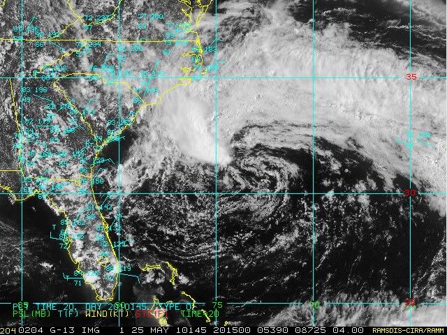
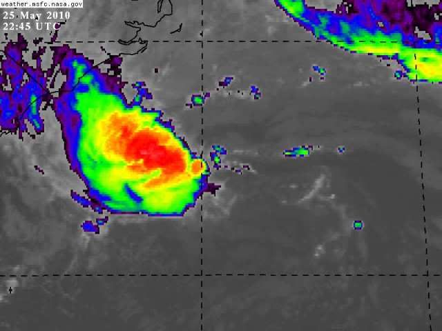
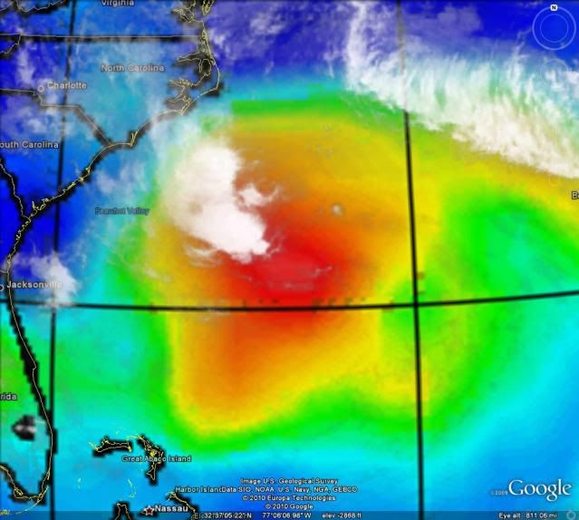
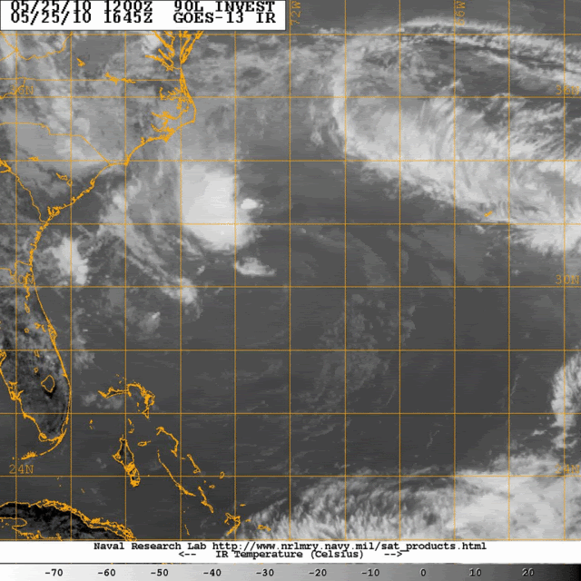
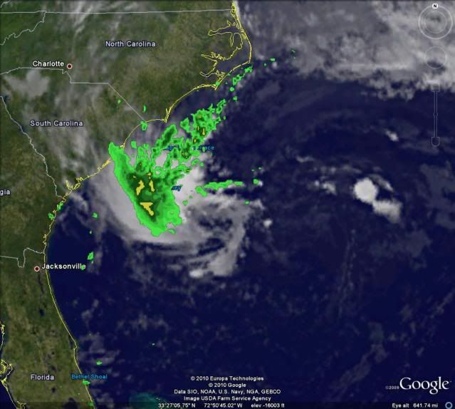
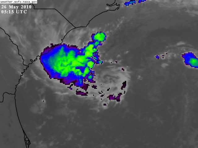
Most important problem is the lack of covergence with the system, there is some weak convergence to the NW which is helping to develop the convection there but its not really enough yet...

That being said if the convection can hold where it is right now then we may see it back upto orange in 12hrs time or so. Still doesn't look that good, though we've seen only marginally better looking systems upgraded before...but in this event I don't think its going to happen.

Looks like the models suggest it has another 48hrs in marginal conditions before the system lifts out ENE/NE.
0 likes   
Personal Forecast Disclaimer:
The posts in this forum are NOT official forecast and should not be used as such. They are just the opinion of the poster and may or may not be backed by sound meteorological data. They are NOT endorsed by any professional institution or storm2k.org. For official information, please refer to the NHC and NWS products

User avatar
Cookie
S2K Supporter
S2K Supporter
Posts: 477
Age: 37
Joined: Sun Dec 14, 2008 11:13 am
Location: Isle Of lewis scotland

#289 Postby Cookie » Tue May 25, 2010 4:47 pm

I don't think people should ever right these things off, until their is zero chance. time and time again watching hurricanes all years around things happen that are unexpected.
0 likes   

User avatar
HURAKAN
Professional-Met
Professional-Met
Posts: 46086
Age: 38
Joined: Thu May 20, 2004 4:34 pm
Location: Key West, FL
Contact:

#290 Postby HURAKAN » Tue May 25, 2010 6:21 pm

Image

Not dead, not just yet!
0 likes   

User avatar
HURAKAN
Professional-Met
Professional-Met
Posts: 46086
Age: 38
Joined: Thu May 20, 2004 4:34 pm
Location: Key West, FL
Contact:

Re: ATL : INVEST 90L

#291 Postby HURAKAN » Tue May 25, 2010 6:50 pm

Image

The most deep it has ever been
0 likes   

User avatar
HURAKAN
Professional-Met
Professional-Met
Posts: 46086
Age: 38
Joined: Thu May 20, 2004 4:34 pm
Location: Key West, FL
Contact:

#292 Postby HURAKAN » Tue May 25, 2010 6:53 pm

Image

Nice pic
0 likes   

JonathanBelles
Professional-Met
Professional-Met
Posts: 11430
Age: 35
Joined: Sat Dec 24, 2005 9:00 pm
Location: School: Florida State University (Tallahassee, FL) Home: St. Petersburg, Florida
Contact:

#293 Postby JonathanBelles » Tue May 25, 2010 6:55 pm

The last hour or so on satellite has been quite interesting. Rain is very near the coast now. The loop current could change things over the next 18+ hours.
0 likes   

User avatar
HURAKAN
Professional-Met
Professional-Met
Posts: 46086
Age: 38
Joined: Thu May 20, 2004 4:34 pm
Location: Key West, FL
Contact:

#294 Postby HURAKAN » Tue May 25, 2010 8:56 pm

Image

Latest
0 likes   

User avatar
HURAKAN
Professional-Met
Professional-Met
Posts: 46086
Age: 38
Joined: Thu May 20, 2004 4:34 pm
Location: Key West, FL
Contact:

#295 Postby HURAKAN » Tue May 25, 2010 9:05 pm

Image

Latest loop
0 likes   

Patrick99
Category 5
Category 5
Posts: 1770
Joined: Mon May 24, 2004 3:43 pm
Location: SW Broward, FL

Re: ATL : INVEST 90L

#296 Postby Patrick99 » Tue May 25, 2010 9:18 pm

That's gotta be some Gulfstream-enhanced convection, right there, I would think.
0 likes   

User avatar
HURAKAN
Professional-Met
Professional-Met
Posts: 46086
Age: 38
Joined: Thu May 20, 2004 4:34 pm
Location: Key West, FL
Contact:

Re: ATL : INVEST 90L

#297 Postby HURAKAN » Tue May 25, 2010 9:18 pm

00z

AL, 90, 2010052600, , BEST, 0, 310N, 734W, 40, 1005, LO
0 likes   

User avatar
HURAKAN
Professional-Met
Professional-Met
Posts: 46086
Age: 38
Joined: Thu May 20, 2004 4:34 pm
Location: Key West, FL
Contact:

#298 Postby HURAKAN » Tue May 25, 2010 9:37 pm

Image

comparison
0 likes   

User avatar
HURAKAN
Professional-Met
Professional-Met
Posts: 46086
Age: 38
Joined: Thu May 20, 2004 4:34 pm
Location: Key West, FL
Contact:

#299 Postby HURAKAN » Tue May 25, 2010 11:30 pm

Image

Satellite + Radar
0 likes   

User avatar
HURAKAN
Professional-Met
Professional-Met
Posts: 46086
Age: 38
Joined: Thu May 20, 2004 4:34 pm
Location: Key West, FL
Contact:

#300 Postby HURAKAN » Wed May 26, 2010 12:31 am

Image

Today could be interesting
0 likes   


Return to “2010”

Who is online

Users browsing this forum: No registered users and 0 guests