

353
WFUS54 KTSA 102218
TORTSA
OKC113-117-102300-
/O.NEW.KTSA.TO.W.0003.100510T2218Z-100510T2300Z/
BULLETIN - EAS ACTIVATION REQUESTED
TORNADO WARNING
NATIONAL WEATHER SERVICE TULSA OK
518 PM CDT MON MAY 10 2010
THE NATIONAL WEATHER SERVICE IN TULSA HAS ISSUED A
* TORNADO WARNING FOR...
NORTHERN OSAGE COUNTY IN NORTHEAST OKLAHOMA
PAWNEE COUNTY IN NORTHEAST OKLAHOMA
* UNTIL 600 PM CDT
* AT 514 PM CDT...A SEVERE THUNDERSTORM WITH A HISOTRY OF PRODUCING A
TORNADO WAS LOCATED 9 MILES WEST OF FAIRFAX...MOVING EAST AT 40
MPH. THIS IS A DANGEROUS STORM...TAKE COVER NOW!
* SOME LOCATIONS IN OR NEAR THE PATH OF THIS STORM INCLUDE...
BURBANK...FAIRFAX...FORAKER...PAWHUSKA...PEARSONIA...SHIDLER AND
WYNONA.
PRECAUTIONARY/PREPAREDNESS ACTIONS...
Next round of severe weather 7th May Onwards?
Moderator: S2k Moderators
Forum rules

The posts in this forum are NOT official forecast and should not be used as such. They are just the opinion of the poster and may or may not be backed by sound meteorological data. They are NOT endorsed by any professional institution or STORM2K.

-
Dave

- Retired Staff

- Posts: 13442
- Age: 75
- Joined: Tue Aug 01, 2006 3:57 pm
- Location: Milan Indiana
- Contact:
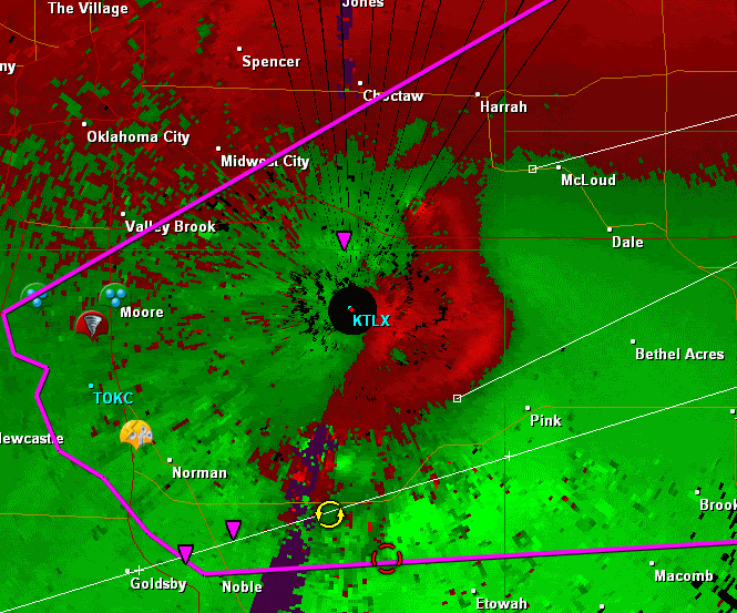
LINCOLN OK-OKLAHOMA OK-POTTAWATOMIE OK-CLEVELAND OK-
536 PM CDT MON MAY 10 2010
...A TORNADO WARNING REMAINS IN EFFECT UNTIL 615 PM CDT FOR NORTHERN
CLEVELAND...NORTHERN POTTAWATOMIE...SOUTHEASTERN OKLAHOMA AND
SOUTHWESTERN LINCOLN COUNTIES...
AT 536 PM CDT...NATIONAL WEATHER SERVICE RADAR DETECTED A SEVERE
THUNDERSTORM CAPABLE OF PRODUCING A TORNADO NEAR HIGHWAY 9 AND
HIGHWAY 77...MOVING NORTHEAST AT 50 MPH.
* LOCATIONS IN THE WARNING INCLUDE MOORE...NORMAN...SHAWNEE AND
SOUTHEASTERN OKLAHOMA CITY.
THIS INCLUDES INTERSTATE 35 BETWEEN MILE MARKERS 109 AND 120.
THIS INCLUDES INTERSTATE 40 BETWEEN MILE MARKERS 160 AND 192.
PRECAUTIONARY/PREPAREDNESS ACTIONS...
IN ADDITION TO A TORNADO THREAT... THIS STORM LIKELY CONTAINS
DAMAGING HAIL TO THE SIZE OF BASEBALLS OR LARGER.
A TORNADO MAY FORM AT ANYTIME. TAKE COVER NOW. ABANDON MOBILE HOMES
AND VEHICLES. IF POSSIBLE... MOVE TO A BASEMENT OR STORM SHELTER.
OTHERWISE... MOVE TO AN INTERIOR ROOM OR HALLWAY ON THE LOWEST FLOOR.
STAY AWAY FROM WINDOWS.
0 likes
-
apocalypt-flyer
- Category 1

- Posts: 468
- Joined: Sat Aug 27, 2005 11:51 am
-
brunota2003

- S2K Supporter

- Posts: 9476
- Age: 35
- Joined: Sat Jul 30, 2005 9:56 pm
- Location: Stanton, KY...formerly Havelock, NC
- Contact:


Wow I go away for two hours and all hell breaks loose from the looks of things!!
Certainly does appear to be quite a severe event at the moment out there, hope all the storm chasers are safe
Certainly does appear to be quite a severe event at the moment out there, hope all the storm chasers are safe
0 likes
Personal Forecast Disclaimer:
The posts in this forum are NOT official forecast and should not be used as such. They are just the opinion of the poster and may or may not be backed by sound meteorological data. They are NOT endorsed by any professional institution or storm2k.org. For official information, please refer to the NHC and NWS products
The posts in this forum are NOT official forecast and should not be used as such. They are just the opinion of the poster and may or may not be backed by sound meteorological data. They are NOT endorsed by any professional institution or storm2k.org. For official information, please refer to the NHC and NWS products
-
Texas Snowman

- Storm2k Moderator

- Posts: 6197
- Joined: Fri Jan 25, 2008 11:29 am
- Location: Denison, Texas
MASSIVE TORNADO on the ground in or very near eastern Norman.
Trailer park reportedly demolished...
Trailer park reportedly demolished...
0 likes
The above post and any post by Texas Snowman is NOT an official forecast and should not be used as such. It is just the opinion of the poster and may or may not be backed by sound meteorological data. It is NOT endorsed by any professional institution including storm2k.org. For official information, please refer to NWS products.
-
apocalypt-flyer
- Category 1
- Posts: 468
- Joined: Sat Aug 27, 2005 11:51 am
Apparently a trailer park nearby Norman BADLY damaged with lots of debris.
Last edited by apocalypt-flyer on Mon May 10, 2010 5:46 pm, edited 1 time in total.
0 likes

-
srainhoutx

- S2K Supporter
- Posts: 6919
- Age: 68
- Joined: Sun Jan 14, 2007 11:34 am
- Location: Haywood County, NC
- Contact:
Re: Next round of severe weather 7th May Onwards?
0 likes
Carla/Alicia/Jerry(In The Eye)/Michelle/Charley/Ivan/Dennis/Katrina/Rita/Wilma/Ike/Harvey
Member: National Weather Association
Wx Infinity Forums
http://wxinfinity.com/index.php
Facebook.com/WeatherInfinity
Twitter @WeatherInfinity
Member: National Weather Association
Wx Infinity Forums
http://wxinfinity.com/index.php
Facebook.com/WeatherInfinity
Twitter @WeatherInfinity
-
brunota2003
- S2K Supporter
- Posts: 9476
- Age: 35
- Joined: Sat Jul 30, 2005 9:56 pm
- Location: Stanton, KY...formerly Havelock, NC
- Contact:
-
Dave
- Retired Staff
- Posts: 13442
- Age: 75
- Joined: Tue Aug 01, 2006 3:57 pm
- Location: Milan Indiana
- Contact:
LINCOLN OK-OKLAHOMA OK-POTTAWATOMIE OK-CLEVELAND OK-
546 PM CDT MON MAY 10 2010
...A TORNADO WARNING REMAINS IN EFFECT UNTIL 615 PM CDT FOR
NORTHEASTERN CLEVELAND...NORTHERN POTTAWATOMIE...SOUTHEASTERN
OKLAHOMA AND SOUTHWESTERN LINCOLN COUNTIES...
AT 546 PM CDT...RADAR AND STORM SPOTTERS OBSERVED A TORNADO NEAR
EAST 108TH AND ALAMEDA HEADING TOWARDS LAKE THUNDERBIRD...MOVING
EAST AT 45 MPH.
* LOCATIONS IN THE WARNING INCLUDE EASTERN NORMAN...SHAWNEE AND
SOUTHEASTERN OKLAHOMA CITY.
THIS INCLUDES INTERSTATE 40 BETWEEN MILE MARKERS 160 AND 192.
PRECAUTIONARY/PREPAREDNESS ACTIONS...
IN ADDITION TO A TORNADO THREAT... THIS STORM LIKELY CONTAINS
DAMAGING HAIL TO THE SIZE OF BASEBALLS OR LARGER.
TAKE COVER NOW. LEAVE MOBILE HOMES AND VEHICLES. IF POSSIBLE...MOVE
TO A BASEMENT OR STORM SHELTER. OTHERWISE MOVE TO AN INTERIOR ROOM OR
HALLWAY ON THE LOWEST FLOOR. STAY AWAY FROM WINDOWS AND OUTSIDE
WALLS.
0 likes

Return to “USA & Caribbean Weather”
Who is online
Users browsing this forum: No registered users and 157 guests