Next round of severe weather 7th May Onwards?
Moderator: S2k Moderators
Forum rules

The posts in this forum are NOT official forecast and should not be used as such. They are just the opinion of the poster and may or may not be backed by sound meteorological data. They are NOT endorsed by any professional institution or STORM2K.
-
brunota2003

- S2K Supporter

- Posts: 9476
- Age: 35
- Joined: Sat Jul 30, 2005 9:56 pm
- Location: Stanton, KY...formerly Havelock, NC
- Contact:


Amazing tornadic supercells in progress across OK and KS. Incredible event unfolding.
0 likes
The following post is NOT an official forecast and should not be used as such. It is just the opinion of the poster and may or may not be backed by sound meteorological data. It is NOT endorsed by any professional institution including storm2k.org For Official Information please refer to the NHC and NWS products.

-
Dave

- Retired Staff

- Posts: 13442
- Age: 75
- Joined: Tue Aug 01, 2006 3:57 pm
- Location: Milan Indiana
- Contact:
CHAUTAUQUA KS-ELK KS-
534 PM CDT MON MAY 10 2010
...A TORNADO WARNING REMAINS IN EFFECT FOR ELK AND NORTHERN
CHAUTAUQUA COUNTIES UNTIL 615 PM CDT...
AT 530 PM CDT...TRAINED WEATHER SPOTTERS REPORTED A TORNADO ON THE
GROUND 4 MILES SOUTH OF GENOLA. THIS TORNADO WAS LOCATED NEAR
GRENOLA...OR 18 MILES NORTHWEST OF SEDAN...MOVING NORTHEAST AT 40
MPH.
LOCATIONS IMPACTED INCLUDE...
GRENOLA...MOLINE...ELK FALLS...HOWARD AND LONGTON.
PRECAUTIONARY/PREPAREDNESS ACTIONS...
TO REPEAT...A TORNADO IS ON THE GROUND. TAKE COVER NOW.
0 likes
-
Dave
- Retired Staff
- Posts: 13442
- Age: 75
- Joined: Tue Aug 01, 2006 3:57 pm
- Location: Milan Indiana
- Contact:
GARVIN OK-
535 PM CDT MON MAY 10 2010
...A TORNADO WARNING REMAINS IN EFFECT UNTIL 545 PM CDT FOR
NORTHWESTERN GARVIN COUNTY...
AT 535 PM CDT...A TORNADO WAS DETECTED BY RADAR 7 MILES SOUTH OF
LINDSAY...MOVING NORTHEAST AT 60 MPH.
* LOCATIONS IN THE WARNING INCLUDE ERIN SPRINGS...LINDSAY AND
MAYSVILLE.
535 PM CDT MON MAY 10 2010
...A TORNADO WARNING REMAINS IN EFFECT UNTIL 545 PM CDT FOR
NORTHWESTERN GARVIN COUNTY...
AT 535 PM CDT...A TORNADO WAS DETECTED BY RADAR 7 MILES SOUTH OF
LINDSAY...MOVING NORTHEAST AT 60 MPH.
* LOCATIONS IN THE WARNING INCLUDE ERIN SPRINGS...LINDSAY AND
MAYSVILLE.
0 likes
-
brunota2003
- S2K Supporter
- Posts: 9476
- Age: 35
- Joined: Sat Jul 30, 2005 9:56 pm
- Location: Stanton, KY...formerly Havelock, NC
- Contact:
Re:
CrazyC83 wrote:Tornado now on the ground over Norman.
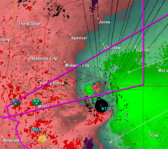
Look at the latest radar return for the SRV!!! There is something VERY large on the ground right near the radar
0 likes
-
Texas Snowman

- Storm2k Moderator

- Posts: 6197
- Joined: Fri Jan 25, 2008 11:29 am
- Location: Denison, Texas
Re: Next round of severe weather 7th May Onwards?
Norman tornado rotation reported over NWS. Debris reported in the air.
Moore tornado rotation just west of Little River State park.
Moore tornado rotation just west of Little River State park.
0 likes
The above post and any post by Texas Snowman is NOT an official forecast and should not be used as such. It is just the opinion of the poster and may or may not be backed by sound meteorological data. It is NOT endorsed by any professional institution including storm2k.org. For official information, please refer to NWS products.
-
apocalypt-flyer
- Category 1

- Posts: 468
- Joined: Sat Aug 27, 2005 11:51 am
-
Texas Snowman
- Storm2k Moderator
- Posts: 6197
- Joined: Fri Jan 25, 2008 11:29 am
- Location: Denison, Texas
SEVERE WEATHER STATEMENT
NATIONAL WEATHER SERVICE TULSA OK
528 PM CDT MON MAY 10 2010
OKC113-102300-
/O.CON.KTSA.TO.W.0003.000000T0000Z-100510T2300Z/
OSAGE OK-
528 PM CDT MON MAY 10 2010
...THE TORNADO WARNING FOR CENTRAL OSAGE COUNTY CONTINUES...
AT 525 PM CDT...NWS METEOROLOGISTS CONTINUED TO TRACK A SEVERE
THUNDERSTORM WITH A HISTORY OF PRODUCING A TORNADO LOCATED NEAR
BURBANK...MOVING EAST AT 40 MPH. THIS VERY DANGEROUS STORM HAS A
HISTORY OF PRODUCING A TORNADO...TAKE COVER NOW!
SOME LOCATIONS IN OR NEAR THE PATH OF THIS STORM INCLUDE...SHIDLER...
PEARSONIA...PAWHUSKA...NELAGONEY AND PERSHING.
PRECAUTIONARY/PREPAREDNESS ACTIONS...
IF YOU ARE NEAR THE PATH OF THIS STORM...TAKE COVER NOW! IF NO
UNDERGROUND SHELTER IS AVAILABLE MOVE TO AN INTERIOR ROOM ON THE
LOWEST FLOOR. MOBILE HOMES AND VEHICLES SHOULD BE ABANDONED FOR MORE
SUBSTANTIAL SHELTER. AVOID WINDOWS!
A TORNADO WARNING REMAINS IN EFFECT UNTIL 600 PM CDT FOR CENTRAL
OSAGE COUNTY.
&&
LAT...LON 3654 9619 3656 9671 3662 9681 3673 9681
3700 9635 3700 9627
TIME...MOT...LOC 2228Z 261DEG 36KT 3665 9671
$$
0 likes
The above post and any post by Texas Snowman is NOT an official forecast and should not be used as such. It is just the opinion of the poster and may or may not be backed by sound meteorological data. It is NOT endorsed by any professional institution including storm2k.org. For official information, please refer to NWS products.
-
Texas Snowman
- Storm2k Moderator
- Posts: 6197
- Joined: Fri Jan 25, 2008 11:29 am
- Location: Denison, Texas
SEVERE WEATHER STATEMENT
NATIONAL WEATHER SERVICE NORMAN OK
535 PM CDT MON MAY 10 2010
OKC049-102245-
/O.CON.KOUN.TO.W.0011.000000T0000Z-100510T2245Z/
GARVIN OK-
535 PM CDT MON MAY 10 2010
...A TORNADO WARNING REMAINS IN EFFECT UNTIL 545 PM CDT FOR
NORTHWESTERN GARVIN COUNTY...
AT 535 PM CDT...A TORNADO WAS DETECTED BY RADAR 7 MILES SOUTH OF
LINDSAY...MOVING NORTHEAST AT 60 MPH.
* LOCATIONS IN THE WARNING INCLUDE ERIN SPRINGS...LINDSAY AND
MAYSVILLE.
LAT...LON 3486 9767 3486 9752 3487 9751 3486 9734
3485 9734 3468 9756 3469 9767
TIME...MOT...LOC 2235Z 234DEG 51KT 3478 9758
$$
BURKE
0 likes
The above post and any post by Texas Snowman is NOT an official forecast and should not be used as such. It is just the opinion of the poster and may or may not be backed by sound meteorological data. It is NOT endorsed by any professional institution including storm2k.org. For official information, please refer to NWS products.

575
WFUS54 KOUN 102226
TOROUN
OKC027-081-109-125-102315-
/O.NEW.KOUN.TO.W.0012.100510T2226Z-100510T2315Z/
BULLETIN - EAS ACTIVATION REQUESTED
TORNADO WARNING
NATIONAL WEATHER SERVICE NORMAN OK
526 PM CDT MON MAY 10 2010
THE NATIONAL WEATHER SERVICE IN NORMAN HAS ISSUED A
* TORNADO WARNING FOR...
NORTHERN CLEVELAND COUNTY IN CENTRAL OKLAHOMA...
SOUTHWESTERN LINCOLN COUNTY IN CENTRAL OKLAHOMA...
SOUTHEASTERN OKLAHOMA COUNTY IN CENTRAL OKLAHOMA...
NORTHERN POTTAWATOMIE COUNTY IN CENTRAL OKLAHOMA...
* UNTIL 615 PM CDT
* AT 527 PM CDT...NATIONAL WEATHER SERVICE RADAR INDICATED A SEVERE
THUNDERSTORM CAPABLE OF PRODUCING A TORNADO OVER WESTERN NORMAN...4
MILES WEST OF DOWNTOWN NORMAN...MOVING NORTHEAST AT 70 MPH.
* LOCATIONS IN THE WARNING INCLUDE AYDELOTTE...BETHEL ACRES...
BROOKSVILLE...DALE...EARLSBORO...HARJO...HARRAH...JOHNSON...LAKE
THUNDERBIRD...MCLOUD...MEEKER...MOORE...NEWALLA...NOBLE...NORMAN...
PINK...SHAWNEE...SOUTHEASTERN OKLAHOMA CITY...STANLEY DRAPER
LAKE...STELLA...TECUMSEH AND TINKER AIR FORCE BASE.
THIS INCLUDES INTERSTATE 35 BETWEEN MILE MARKERS 109 AND 120.
THIS INCLUDES INTERSTATE 40 BETWEEN MILE MARKERS 160 AND 192.
0 likes
-
Texas Snowman
- Storm2k Moderator
- Posts: 6197
- Joined: Fri Jan 25, 2008 11:29 am
- Location: Denison, Texas
TV shooting tornado on the ground in OKC...
0 likes
The above post and any post by Texas Snowman is NOT an official forecast and should not be used as such. It is just the opinion of the poster and may or may not be backed by sound meteorological data. It is NOT endorsed by any professional institution including storm2k.org. For official information, please refer to NWS products.

249
WFUS54 KOUN 102225
TOROUN
OKC049-051-137-102245-
/O.NEW.KOUN.TO.W.0011.100510T2225Z-100510T2245Z/
BULLETIN - EAS ACTIVATION REQUESTED
TORNADO WARNING
NATIONAL WEATHER SERVICE NORMAN OK
525 PM CDT MON MAY 10 2010
THE NATIONAL WEATHER SERVICE IN NORMAN HAS ISSUED A
* TORNADO WARNING FOR...
SOUTHEASTERN GRADY COUNTY IN CENTRAL OKLAHOMA...
NORTHWESTERN GARVIN COUNTY IN SOUTHERN OKLAHOMA...
NORTHEASTERN STEPHENS COUNTY IN SOUTHERN OKLAHOMA...
* UNTIL 545 PM CDT
* AT 525 PM CDT...A TORNADO WAS DETECTED BY RADAR 11 MILES SOUTHWEST
OF LINDSAY...MOVING NORTHEAST AT 65 MPH.
* LOCATIONS IN THE WARNING INCLUDE COX CITY...ERIN SPRINGS...LINDSAY
AND MAYSVILLE.
PRECAUTIONARY/PREPAREDNESS ACTIONS...
0 likes
Return to “USA & Caribbean Weather”
Who is online
Users browsing this forum: Cpv17, WeatherNewbie and 83 guests