GOC: EX-TROPICAL CYCLONE PAUL (22P) - Final Advisory

Moderator: S2k Moderators

Message
Author
User avatar
HURAKAN
Professional-Met
Professional-Met
Posts: 46086
Age: 38
Joined: Thu May 20, 2004 4:34 pm
Location: Key West, FL
Contact:

#21 Postby HURAKAN » Sat Mar 27, 2010 5:19 pm

Image

WTPS31 PGTW 272100
MSGID/GENADMIN/NAVMARFCSTCEN PEARL HARBOR HI/JTWC//
SUBJ/TROPICAL CYCLONE 22P (TWENTYTWO) WARNING NR 001//
RMKS/
1. TROPICAL CYCLONE 22P (TWENTYTWO) WARNING NR 001
01 ACTIVE TROPICAL CYCLONE IN SOUTHPAC
MAX SUSTAINED WINDS BASED ON ONE-MINUTE AVERAGE
WIND RADII VALID OVER OPEN WATER ONLY
---
WARNING POSITION:
271800Z --- NEAR 12.9S 136.6E
MOVEMENT PAST SIX HOURS - 180 DEGREES AT 03 KTS
POSITION ACCURATE TO WITHIN 060 NM
POSITION BASED ON CENTER LOCATED BY SATELLITE
PRESENT WIND DISTRIBUTION:
MAX SUSTAINED WINDS - 035 KT, GUSTS 045 KT
WIND RADII VALID OVER OPEN WATER ONLY
REPEAT POSIT: 12.9S 136.6E
---
FORECASTS:
12 HRS, VALID AT:
280600Z --- 13.5S 136.5E
MAX SUSTAINED WINDS - 040 KT, GUSTS 050 KT
WIND RADII VALID OVER OPEN WATER ONLY
RADIUS OF 034 KT WINDS - 040 NM NORTHEAST QUADRANT
040 NM SOUTHEAST QUADRANT
030 NM SOUTHWEST QUADRANT
030 NM NORTHWEST QUADRANT
VECTOR TO 24 HR POSIT: 200 DEG/ 03 KTS
---
24 HRS, VALID AT:
281800Z --- 14.0S 136.3E
MAX SUSTAINED WINDS - 045 KT, GUSTS 055 KT
WIND RADII VALID OVER OPEN WATER ONLY
RADIUS OF 034 KT WINDS - 040 NM NORTHEAST QUADRANT
045 NM SOUTHEAST QUADRANT
045 NM SOUTHWEST QUADRANT
040 NM NORTHWEST QUADRANT
VECTOR TO 36 HR POSIT: 225 DEG/ 03 KTS
---
36 HRS, VALID AT:
290600Z --- 14.4S 135.9E
MAX SUSTAINED WINDS - 045 KT, GUSTS 055 KT
WIND RADII VALID OVER OPEN WATER ONLY
RADIUS OF 034 KT WINDS - 040 NM NORTHEAST QUADRANT
045 NM SOUTHEAST QUADRANT
045 NM SOUTHWEST QUADRANT
040 NM NORTHWEST QUADRANT
VECTOR TO 48 HR POSIT: 260 DEG/ 03 KTS
---
EXTENDED OUTLOOK:
48 HRS, VALID AT:
291800Z --- 14.5S 135.3E
MAX SUSTAINED WINDS - 040 KT, GUSTS 050 KT
WIND RADII VALID OVER OPEN WATER ONLY
VECTOR TO 72 HR POSIT: 275 DEG/ 02 KTS
---
72 HRS, VALID AT:
301800Z --- 14.4S 134.5E
MAX SUSTAINED WINDS - 035 KT, GUSTS 045 KT
WIND RADII VALID OVER OPEN WATER ONLY
DISSIPATING AS A SIGNIFICANT TROPICAL CYCLONE OVER LAND
---
REMARKS:
272100Z POSITION NEAR 13.1S 136.6E.
TROPICAL CYCLONE (TC) 22P (TWENTYTWO), LOCATED APPROXIMATELY 340 NM
EAST OF DARWIN, AUSTRALIA, HAS TRACKED SOUTHWARD AT 03 KNOTS OVER
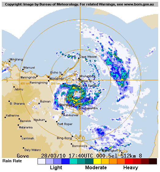
THE PAST SIX HOURS. ANIMATED INFRARED SATELLITE IMAGERY AND RADAR
IMAGERY FROM GOVE, AUSTRALIA SHOW INCREASED CONVECTIVE BANDING
AROUND A LOW LEVEL CIRCULATION CENTER (LLCC). THE LLCC IS LOCATED
JUST OFF THE COAST OF NORTHERN AUSTRALIA IN THE GULF OF CARPENTARIA.
THE INITIAL INTENSITY WAS BASED ON PGTW, KNES, AND ADRM DVORAK
ESTIMATES OF 35 KNOTS. UPPER LEVEL ANALYSIS SHOWS THE SYSTEM IS
LOCATED BENEATH THE SUBTROPICAL RIDGE AXIS WITH GOOD RADIAL OUTFLOW
AND LOW VERTICAL WIND SHEAR. TC 22P IS CURRENTLY LOCATED IN A WEAK
STEERING ENVIRONMENT AND IS SLOWLY TRACKING SOUTHWARD UNDER THE
INFLUENCE OF A NEAR EQUATORIAL RIDGE. TC 22P SHOULD BEGIN TO TURN
SOUTHWEST AND WESTWARD AS A SUBTROPICAL STEERING RIDGE TO THE SOUTH
BUILDS IN. AS TC 22P CONTINUES TRACKING OVER THE WARM WATERS OF THE
GULF OF CARPENTARIA, IT IS EXPECTED TO INTENSIFY UNTIL REACHING LAND
BY TAU 48 AND BEGIN DISSIPATING AS A SIGNIFICANT TROPICAL CYCLONE
AFTER TAU 72. AVAILABLE NUMERICAL MODEL GUIDANCE IS SPREAD DUE TO
THE WEAK STEERING ENVIRONMENT, HOWEVER, THIS FORECAST IS IN
AGREEMENT WITH THE MODELS INCLUDING GFDN, EGRR, AND NOGAPS, WHICH
TURN THE SYSTEM WESTWARD. THE GFS AND WBAR MODELS TRACK TC 22P
SOUTHEASTWARD AND SOUTHWARD, RESPECTIVELY, BECAUSE THEY FORECAST A
WEAKER SUBTROPICAL STEERING RIDGE THAN THE OTHER MODELS. THIS
WARNING SUPERSEDES AND CANCELS REF A, NAVMARFCSTCEN 271700Z MAR 10
TROPICAL CYCLONE FORMATION ALERT (WTPS21 PGTW 271700) MAXIMUM
SIGNIFICANT WAVE HEIGHT AT 271800Z IS 12 FEET. NEXT WARNINGS AT
280900Z AND 282100Z.//
NNNN
0 likes   

User avatar
KWT
Category 5
Category 5
Posts: 31415
Joined: Tue Aug 17, 2004 11:02 am
Location: UK!!!

#22 Postby KWT » Sat Mar 27, 2010 6:35 pm

Looks like its not going to have much room at all to develop and any small changes to the track will bring it inland much faster then forecasted, still been fairly busy in the eastern part of the basin.
0 likes   
Personal Forecast Disclaimer:
The posts in this forum are NOT official forecast and should not be used as such. They are just the opinion of the poster and may or may not be backed by sound meteorological data. They are NOT endorsed by any professional institution or storm2k.org. For official information, please refer to the NHC and NWS products

User avatar
Chacor
Category 5
Category 5
Posts: 10229
Joined: Mon Oct 02, 2006 10:43 pm
Location: Singapore

#23 Postby Chacor » Sat Mar 27, 2010 9:21 pm

This is now Tropical Cyclone PAUL.
0 likes   

User avatar
HURAKAN
Professional-Met
Professional-Met
Posts: 46086
Age: 38
Joined: Thu May 20, 2004 4:34 pm
Location: Key West, FL
Contact:

#24 Postby HURAKAN » Sat Mar 27, 2010 10:30 pm

Image

TROPICAL CYCLONE ADVICE NUMBER 11
Issued by the BUREAU OF METEOROLOGY, DARWIN
at 11:00 am CST Sunday 28 March 2010

A Cyclone WARNING continues for coastal and island communities from Milingimbi
to Port Roper, including Nhulunbuy and Groote Eylandt.

A Cyclone WATCH continues for coastal and island communities from Maningrida to
Milingimbi.

At 9:30 am CST Tropical Cyclone Paul, Category 1 was estimated to be 90
kilometres north of Alyangula and 105 kilometres south southwest of Nhulunbuy,
moving south at 6 kilometres per hour parallel to the coast.

The cyclone is expected to intensify slightly before it moves inland between
CAPE SHIELD and ALYANGULA on Monday.

GALES with gusts to 110 kilometres per hour are currently being experienced
between and NHULUNBUY and PORT ROPER, including GROOTE EYLANDT. GALES may extend
west to MILINGIMBI and MANINGRIDA late Monday if the system takes a more
northerly track.

A STORM TIDE is expected between CAPE SHIELD and PORT ROPER. Tides are likely to
rise significantly above the normal high tide, with DAMAGING WAVES and DANGEROUS
FLOODING today and Monday.

HEAVY RAIN may lead to localised flooding and significant stream rises in the
Arnhem and Roper-McArthur Districts today and Monday.

Details of Tropical Cyclone Paul at 9:30 am CST:
.Centre located near...... 13.1 degrees South 136.5 degrees East
.Location accuracy........ within 30 kilometres
.Recent movement.......... towards the south at 6 kilometres per hour
.Wind gusts near centre... 100 kilometres per hour
.Severity category........ 1
.Central pressure......... 995 hectoPascals

The next advice will be issued by 2:00 pm CST Sunday 28 March.

This advice is available on telephone NT-1300 659 211

DARWIN Tropical Cyclone Warning Centre
0 likes   

User avatar
HURAKAN
Professional-Met
Professional-Met
Posts: 46086
Age: 38
Joined: Thu May 20, 2004 4:34 pm
Location: Key West, FL
Contact:

#25 Postby HURAKAN » Sat Mar 27, 2010 10:32 pm

Image

Image

Latest
0 likes   

User avatar
HURAKAN
Professional-Met
Professional-Met
Posts: 46086
Age: 38
Joined: Thu May 20, 2004 4:34 pm
Location: Key West, FL
Contact:

#26 Postby HURAKAN » Sat Mar 27, 2010 11:55 pm

TROPICAL CYCLONE ADVICE NUMBER 12
Issued by the BUREAU OF METEOROLOGY, DARWIN
at 2:00 pm CST Sunday 28 March 2010

A Cyclone WARNING continues for coastal and island communities from Milingimbi
to Port Roper, including Nhulunbuy and Groote Eylandt.

A Cyclone WATCH continues for coastal and island communities from Maningrida to
Milingimbi.

At 12:30 pm CST Tropical Cyclone Paul, Category 1 was estimated to be 95
kilometres south southwest of Nhulunbuy and 100 kilometres north of Alyangula.
The cyclone is currently nearly stationary near the coast.

The cyclone is expected to intensify slightly before it moves inland between
CAPE SHIELD and ALYANGULA on Monday.

GALES with gusts to 110 kilometres per hour are currently being experienced
between NHULUNBUY and PORT ROPER, including GROOTE EYLANDT. GALES may extend
west to MILINGIMBI and MANINGRIDA late Monday if the system takes a more
northerly track.

A STORM TIDE is expected between CAPE SHIELD and PORT ROPER. Tides are likely to
rise significantly above the normal high tide, with DAMAGING WAVES and DANGEROUS
FLOODING today and Monday.

HEAVY RAIN may lead to localised flooding and significant stream rises in the
Arnhem and Roper-McArthur Districts today and Monday.

Details of Tropical Cyclone Paul at 12:30 pm CST:
.Centre located near...... 13.0 degrees South 136.5 degrees East
.Location accuracy........ within 30 kilometres
.Recent movement.......... nearly stationary
.Wind gusts near centre... 100 kilometres per hour
.Severity category........ 1
.Central pressure......... 994 hectoPascals

The next advice will be issued by 5:00 pm CST Sunday 28 March.

This advice is available on telephone NT-1300 659 211

DARWIN Tropical Cyclone Warning Centre
0 likes   

User avatar
tropicana
Category 5
Category 5
Posts: 8056
Joined: Sat Sep 27, 2003 6:48 pm
Location: Niagara Falls, Ontario, Canada
Contact:

Re: GOC: TROPICAL CYCLONE PAUL (22P)

#27 Postby tropicana » Sun Mar 28, 2010 7:21 am

Hurakan, i'll help you out this morning :)

Australian Government Bureau of Meteorology
Northern Territory
Darwin Regional Forecasting Centre

TOP PRIORITY FOR IMMEDIATE BROADCAST

Media: The Standard Emergency Warning Signal should NOT be used with this
warning.

TROPICAL CYCLONE WARNING

TROPICAL CYCLONE ADVICE NUMBER 14
Issued by the BUREAU OF METEOROLOGY, DARWIN
at 8:00 pm CST Sunday 28 March 2010

A Cyclone WARNING continues for coastal and island communities from Milingimbi
to Port Roper, including Nhulunbuy and Groote Eylandt.

A Cyclone WATCH continues for coastal and island communities from Maningrida to
Milingimbi.

At 6:30 pm CST Tropical Cyclone Paul, Category 1 was estimated to be 95
kilometres south southwest of Nhulunbuy and 100 kilometres north of Alyangula.

The cyclone is currently stationary on the coast near CAPE SHIELD and is
expected to move further inland on Monday.

GALES with gusts to 110 kilometres per hour are currently being experienced
between NHULUNBUY and PORT ROPER, including GROOTE EYLANDT. GALES may extend
north to ELCHO ISLAND and west to MILINGIMBI and MANINGRIDA late Monday if the
system takes a more northerly track.

A STORM TIDE is expected between CAPE SHIELD and PORT ROPER. Tides are likely to
rise significantly above the normal high tide, with DAMAGING WAVES and DANGEROUS
FLOODING today and Monday.

HEAVY RAIN may lead to localised flooding and significant stream rises over the
eastern Top End and northern Roper-McArthur Districts today and Monday.

Details of Tropical Cyclone Paul at 6:30 pm CST:
.Centre located near...... 13.0 degrees South 136.5 degrees East
.Location accuracy........ within 30 kilometres
.Recent movement.......... nearly stationary
.Wind gusts near centre... 110 kilometres per hour
.Severity category........ 1
.Central pressure......... 992 hectoPascals

The next advice will be issued by 11:00 pm CST Sunday 28 March.

This advice is available on telephone NT-1300 659 211

DARWIN Tropical Cyclone Warning Centre
0 likes   

User avatar
KWT
Category 5
Category 5
Posts: 31415
Joined: Tue Aug 17, 2004 11:02 am
Location: UK!!!

#28 Postby KWT » Sun Mar 28, 2010 7:26 am

Looks like this is pretty much inland now, still it did make it to TC and has landfalled, so to speak!
0 likes   
Personal Forecast Disclaimer:
The posts in this forum are NOT official forecast and should not be used as such. They are just the opinion of the poster and may or may not be backed by sound meteorological data. They are NOT endorsed by any professional institution or storm2k.org. For official information, please refer to the NHC and NWS products

User avatar
HURAKAN
Professional-Met
Professional-Met
Posts: 46086
Age: 38
Joined: Thu May 20, 2004 4:34 pm
Location: Key West, FL
Contact:

#29 Postby HURAKAN » Sun Mar 28, 2010 8:08 am

TROPICAL CYCLONE TECHNICAL BULLETIN: AUSTRALIA - NORTHERN REGION
Issued by DARWIN TROPICAL CYCLONE WARNING CENTRE
at: 0755 UTC 28/03/2010
Name: Tropical Cyclone Paul
Identifier: 11U
Data At: 0600 UTC
Latitude: 13.0S
Longitude: 136.6E
Location Accuracy: within 15 nm [30 km]
Movement Towards: northeast [044 deg]
Speed of Movement: 1 knots [3 km/h]
Maximum 10-Minute Wind: 40 knots [75 km/h]
Maximum 3-Second Wind Gust: 55 knots [100 km/h]
Central Pressure: 994 hPa
Radius of 34-knot winds NE quadrant: 90 nm [165 km]
Radius of 34-knot winds SE quadrant: 90 nm [165 km]
Radius of 34-knot winds SW quadrant: 90 nm [165 km]
Radius of 34-knot winds NW quadrant: 60 nm [110 km]
Radius of 48-knot winds NE quadrant:
Radius of 48-knot winds SE quadrant:
Radius of 48-knot winds SW quadrant:
Radius of 48-knot winds NW quadrant:
Radius of 64-knot winds:
Radius of Maximum Winds:
Dvorak Intensity Code: T3.0/3.0/D1.0/24HRS
Pressure of outermost isobar: 1006 hPa
Radius of outermost closed isobar: 150 nm [280 km]
Storm Depth: Deep
FORECAST DATA
Date/Time : Location : Loc. Accuracy: Max Wind : Central Pressure
[UTC] : degrees : nm [km]: knots[km/h]: hPa
+12: 28/1800: 13.1S 136.1E: 045 [085]: 040 [075]: 994
+24: 29/0600: 12.9S 135.6E: 075 [140]: 030 [055]: 1000
+36: 29/1800: 12.7S 135.3E: 110 [200]: 030 [055]: 1000
+48: 30/0600: 12.7S 135.0E: 140 [260]: 030 [055]: 999
+60: 30/1800: 12.9S 135.0E: 190 [345]: 030 [055]: 1000
+72: 31/0600: 13.3S 135.4E: 235 [435]: 030 [055]: 1000
REMARKS:
TC Paul has maintained good structure with persistent deep convection west of
the LLCC and curved bands in the eastern semicircle. The cyclone is nearly
stationary on radar, with a partial eyewall becoming evident during the past 6
hours. Dvorak FT=3.0 based on PAT at 0600 UTC, with DT=MET=2.5.

The broadscale environment remains favourable for further intensification, with
low vertical wind shear and good outflow to the south and north of the system.
However, the cyclone is forecast to drift slowly west over land under the
influence of a building mid-level ridge to the south. The cyclone may weaken
into a deep monsoon low within 24 or 48 hours, if it remains over land, causing
near gale-force winds and heavy rainfall over Arnhem Land. In the longer term,
there is a risk that the system could move back over the southern Arafura Sea or
Gulf of Carpentaria later in the week where it is likely to reintensify.


Copyright Commonwealth of Australia
==
The next bulletin for this system will be issued by: 28/1330 UTC by Darwin TCWC.
0 likes   

User avatar
HURAKAN
Professional-Met
Professional-Met
Posts: 46086
Age: 38
Joined: Thu May 20, 2004 4:34 pm
Location: Key West, FL
Contact:

#30 Postby HURAKAN » Sun Mar 28, 2010 8:09 am

Image

Latest
0 likes   

User avatar
HURAKAN
Professional-Met
Professional-Met
Posts: 46086
Age: 38
Joined: Thu May 20, 2004 4:34 pm
Location: Key West, FL
Contact:

#31 Postby HURAKAN » Sun Mar 28, 2010 8:35 am

Image

WTPS31 PGTW 280900
MSGID/GENADMIN/NAVMARFCSTCEN PEARL HARBOR HI/JTWC//
SUBJ/TROPICAL CYCLONE 22P (PAUL) WARNING NR 002//
RMKS/
1. TROPICAL CYCLONE 22P (PAUL) WARNING NR 002
01 ACTIVE TROPICAL CYCLONE IN SOUTHPAC
MAX SUSTAINED WINDS BASED ON ONE-MINUTE AVERAGE
WIND RADII VALID OVER OPEN WATER ONLY
---
WARNING POSITION:
280600Z --- NEAR 13.2S 136.5E
MOVEMENT PAST SIX HOURS - 180 DEGREES AT 02 KTS
POSITION ACCURATE TO WITHIN 060 NM
POSITION BASED ON CENTER LOCATED BY SATELLITE
PRESENT WIND DISTRIBUTION:
MAX SUSTAINED WINDS - 040 KT, GUSTS 050 KT
WIND RADII VALID OVER OPEN WATER ONLY
RADIUS OF 034 KT WINDS - 030 NM NORTHEAST QUADRANT
040 NM SOUTHEAST QUADRANT
035 NM SOUTHWEST QUADRANT
030 NM NORTHWEST QUADRANT
REPEAT POSIT: 13.2S 136.5E
---
FORECASTS:
12 HRS, VALID AT:
281800Z --- 13.5S 136.3E
MAX SUSTAINED WINDS - 045 KT, GUSTS 055 KT
WIND RADII VALID OVER OPEN WATER ONLY
RADIUS OF 034 KT WINDS - 030 NM NORTHEAST QUADRANT
045 NM SOUTHEAST QUADRANT
035 NM SOUTHWEST QUADRANT
030 NM NORTHWEST QUADRANT
VECTOR TO 24 HR POSIT: 230 DEG/ 02 KTS
---
24 HRS, VALID AT:
290600Z --- 13.8S 135.9E
MAX SUSTAINED WINDS - 040 KT, GUSTS 050 KT
WIND RADII VALID OVER OPEN WATER ONLY
RADIUS OF 034 KT WINDS - 030 NM NORTHEAST QUADRANT
030 NM SOUTHEAST QUADRANT
025 NM SOUTHWEST QUADRANT
025 NM NORTHWEST QUADRANT
VECTOR TO 36 HR POSIT: 250 DEG/ 03 KTS
---
36 HRS, VALID AT:
291800Z --- 14.0S 135.4E
MAX SUSTAINED WINDS - 035 KT, GUSTS 045 KT
WIND RADII VALID OVER OPEN WATER ONLY
DISSIPATING AS A SIGNIFICANT TROPICAL CYCLONE OVER LAND
RADIUS OF 034 KT WINDS - 005 NM NORTHEAST QUADRANT
005 NM SOUTHEAST QUADRANT
005 NM SOUTHWEST QUADRANT
005 NM NORTHWEST QUADRANT
VECTOR TO 48 HR POSIT: 270 DEG/ 02 KTS
---
EXTENDED OUTLOOK:
48 HRS, VALID AT:
300600Z --- 14.0S 134.9E
MAX SUSTAINED WINDS - 030 KT, GUSTS 040 KT
WIND RADII VALID OVER OPEN WATER ONLY
DISSIPATED AS A SIGNIFICANT TROPICAL CYCLONE OVER LAND
---
REMARKS:
280900Z POSITION NEAR 13.3S 136.5E.
TROPICAL CYCLONE (TC) 22P (PAUL), LOCATED APPROXIMATELY 330 NM
EAST OF DARWIN, AUSTRALIA, HAS TRACKED SOUTHWARD AT 02 KNOTS OVER
THE PAST SIX HOURS. ANIMATED MULTISPECTRAL SATELLITE AND RADAR
IMAGERY FROM GOVE, AUSTRALIA SHOW ORGANIZED CONVECTIVE BANDING
AROUND A WELL-DEFINED LOW LEVEL CIRCULATION CENTER (LLCC). THE
CURRENT POSITION IS BASED ON RADAR ANIMATION AND THE CURRENT
INTENSITY IS EXTRAPOLATED FROM A SURFACE OBSERVATION OF 36 KNOTS FROM
NORTHEAST ISLAND, 38 NM TO THE SOUTH OF THE LLCC. UPPER LEVEL
ANALYSIS INDICATES THE SYSTEM IS UNDER THE SUBTROPICAL RIDGE AXIS
WITH GOOD RADIAL OUTFLOW AND LOW VERTICAL WIND SHEAR. TC 22P IS
CURRENTLY IN A WEAK STEERING ENVIRONMENT AND IS SLOWLY TRACKING
SOUTHWARD UNDER THE INFLUENCE OF A NEAR EQUATORIAL RIDGE. TC 22P
SHOULD BEGIN TO TURN SOUTHWESTWARD AS A SUBTROPICAL RIDGE TO THE
SOUTH BUILDS IN AND STEERS THE SYSTEM. PAUL IS EXPECTED TO INTENSIFY
SLIGHTLY AS IT DRIFTS ACROSS THE WARM WATERS OF THE GULF OF
CARPENTARIA BEFORE IT MAKES LANDFALL NEAR BLUE MUD BAY BY TAU 24 AND
EVENTUALLY DISSIPATE AS A SIGNIFICANT TROPICAL CYCLONE OVER LAND BY
TAU 48. THE AVAILABLE NUMERICAL MODEL GUIDANCE IS SPREAD DUE TO THE
WEAK STEERING ENVIRONMENT. THIS FORECAST IS TO THE SOUTH OF CONSENSUS
FAVORING A GRADUALLY WEAKENING SYSTEM. MAXIMUM SIGNIFICANT WAVE
HEIGHT AT 280600Z IS 13 FEET. NEXT WARNINGS AT 282100Z AND 290900Z.//
NNNN
0 likes   

User avatar
HURAKAN
Professional-Met
Professional-Met
Posts: 46086
Age: 38
Joined: Thu May 20, 2004 4:34 pm
Location: Key West, FL
Contact:

#32 Postby HURAKAN » Sun Mar 28, 2010 9:35 am

TROPICAL CYCLONE ADVICE NUMBER 15
Issued by the BUREAU OF METEOROLOGY, DARWIN
at 11:00 pm CST Sunday 28 March 2010

A Cyclone WARNING continues for coastal and island communities from Milingimbi
to Port Roper, including Nhulunbuy and Groote Eylandt.

A Cyclone WATCH continues for coastal and island communities from Maningrida to
Milingimbi.

At 9:30 pm CST Tropical Cyclone Paul, Category 1 was estimated to be 85
kilometres south southwest of Nhulunbuy and 110 kilometres north of Alyangula.

The cyclone is currently stationary on the coast near CAPE SHIELD and is
expected to move further inland during Monday.

GALES with gusts to 110 kilometres per hour are currently being experienced
between NHULUNBUY and PORT ROPER, including GROOTE EYLANDT. GALES may extend
north to ELCHO ISLAND and west to MILINGIMBI and MANINGRIDA late Monday if the
system takes a more northerly track.

A STORM TIDE is expected between CAPE SHIELD and PORT ROPER. Tides are likely to
rise significantly above the normal high tide, with DAMAGING WAVES and DANGEROUS
FLOODING today and Monday.

HEAVY RAIN may lead to localised flooding and significant stream rises over the
eastern Top End and northern Roper-McArthur Districts today and Monday.

Details of Tropical Cyclone Paul at 9:30 pm CST:
.Centre located near...... 12.9 degrees South 136.5 degrees East
.Location accuracy........ within 30 kilometres
.Recent movement.......... nearly stationary
.Wind gusts near centre... 110 kilometres per hour
.Severity category........ 1
.Central pressure......... 991 hectoPascals

The next advice will be issued by 2:00 am CST Monday 29 March.

This advice is available on telephone NT-1300 659 211

DARWIN Tropical Cyclone Warning Centre


Image
0 likes   

User avatar
HURAKAN
Professional-Met
Professional-Met
Posts: 46086
Age: 38
Joined: Thu May 20, 2004 4:34 pm
Location: Key West, FL
Contact:

#33 Postby HURAKAN » Sun Mar 28, 2010 12:08 pm

Image

Latest
0 likes   

User avatar
KWT
Category 5
Category 5
Posts: 31415
Joined: Tue Aug 17, 2004 11:02 am
Location: UK!!!

#34 Postby KWT » Sun Mar 28, 2010 12:51 pm

The structure is actually pretty good looking at that, got some good banding to it so actually maybe stronger then this morning.

Still some disagreements with regards to the track mind you...
0 likes   
Personal Forecast Disclaimer:
The posts in this forum are NOT official forecast and should not be used as such. They are just the opinion of the poster and may or may not be backed by sound meteorological data. They are NOT endorsed by any professional institution or storm2k.org. For official information, please refer to the NHC and NWS products

User avatar
HURAKAN
Professional-Met
Professional-Met
Posts: 46086
Age: 38
Joined: Thu May 20, 2004 4:34 pm
Location: Key West, FL
Contact:

#35 Postby HURAKAN » Sun Mar 28, 2010 1:16 pm

Image

Very nice!
0 likes   

User avatar
HURAKAN
Professional-Met
Professional-Met
Posts: 46086
Age: 38
Joined: Thu May 20, 2004 4:34 pm
Location: Key West, FL
Contact:

#36 Postby HURAKAN » Sun Mar 28, 2010 1:52 pm

Image

Image

Looking great
0 likes   

User avatar
KWT
Category 5
Category 5
Posts: 31415
Joined: Tue Aug 17, 2004 11:02 am
Location: UK!!!

#37 Postby KWT » Sun Mar 28, 2010 2:09 pm

Yeah the eye is just off the coast and whilst shallow, the waters are nice and hot and no doubt this helping to strengthening Paul quite a bit in the last 12-18hrs.

Does look good, in fact I'd bet that its not far from 65kts at the moment, maybe 55kts at the moment, with the eye still half on land and half at sea.
0 likes   
Personal Forecast Disclaimer:
The posts in this forum are NOT official forecast and should not be used as such. They are just the opinion of the poster and may or may not be backed by sound meteorological data. They are NOT endorsed by any professional institution or storm2k.org. For official information, please refer to the NHC and NWS products

User avatar
HURAKAN
Professional-Met
Professional-Met
Posts: 46086
Age: 38
Joined: Thu May 20, 2004 4:34 pm
Location: Key West, FL
Contact:

Re: GOC: TROPICAL CYCLONE PAUL (22P)

#38 Postby HURAKAN » Sun Mar 28, 2010 4:37 pm

TROPICAL CYCLONE ADVICE NUMBER 17
Issued by the BUREAU OF METEOROLOGY, DARWIN
at 5:00 am CST Monday 29 March 2010

A Cyclone WARNING continues for coastal and island communities from Milingimbi
to Port Roper, including Nhulunbuy and Groote Eylandt.

A Cyclone WATCH continues for coastal and island communities from Maningrida to
Milingimbi.

At 3:30 am CST Tropical Cyclone Paul, Category 2 was estimated to be 90
kilometres south of Nhulunbuy and 105 kilometres north northeast of Alyangula.

The cyclone is currently near-stationary on the coast near CAPE SHIELD and is
expected to move further inland later today.

DESTRUCTIVE WINDS with gusts to 130 kilometres per hour may develop between
Nhulunbuy and Numbulwar during today and Tuesday.

GALES with gusts to 110 kilometres per hour are currently being experienced
between NHULUNBUY and PORT ROPER, including GROOTE EYLANDT. GALES may extend
north to ELCHO ISLAND and west to MILINGIMBI later today and further west to
MANINGRIDA during Tuesday if the system takes a more northerly track.

A STORM TIDE is expected between CAPE SHIELD and PORT ROPER. Tides are likely to
rise significantly above the normal high tide, with DAMAGING WAVES and DANGEROUS
FLOODING today.

HEAVY RAIN may lead to localised flooding and significant stream rises over the
eastern Top End and northern Roper-McArthur Districts today and Tuesday.

Details of Tropical Cyclone Paul at 3:30 am CST:
.Centre located near...... 13.0 degrees South 136.7 degrees East
.Location accuracy........ within 30 kilometres
.Recent movement.......... nearly stationary
.Wind gusts near centre... 130 kilometres per hour
.Severity category........ 2
.Central pressure......... 988 hectoPascals

The next advice will be issued by 8:00 am CST Monday 29 March.

This advice is available on telephone NT-1300 659 211

DARWIN Tropical Cyclone Warning Centre


Image
0 likes   

User avatar
HURAKAN
Professional-Met
Professional-Met
Posts: 46086
Age: 38
Joined: Thu May 20, 2004 4:34 pm
Location: Key West, FL
Contact:

#39 Postby HURAKAN » Sun Mar 28, 2010 4:38 pm

TROPICAL CYCLONE TECHNICAL BULLETIN: AUSTRALIA - NORTHERN REGION
Issued by DARWIN TROPICAL CYCLONE WARNING CENTRE
at: 2014 UTC 28/03/2010
Name: Tropical Cyclone Paul
Identifier: 11U
Data At: 1800 UTC
Latitude: 13.0S
Longitude: 136.7E
Location Accuracy: within 15 nm [30 km]
Movement Towards: east [090 deg]
Speed of Movement: 0 knots [1 km/h]
Maximum 10-Minute Wind: 50 knots [95 km/h]
Maximum 3-Second Wind Gust: 70 knots [130 km/h]
Central Pressure: 988 hPa
Radius of 34-knot winds NE quadrant: 45 nm [85 km]
Radius of 34-knot winds SE quadrant: 60 nm [110 km]
Radius of 34-knot winds SW quadrant: 60 nm [110 km]
Radius of 34-knot winds NW quadrant: 40 nm [75 km]
Radius of 48-knot winds NE quadrant: 10 nm [20 km]
Radius of 48-knot winds SE quadrant: 10 nm [20 km]
Radius of 48-knot winds SW quadrant: 10 nm [20 km]
Radius of 48-knot winds NW quadrant: 10 nm [20 km]
Radius of 64-knot winds:
Radius of Maximum Winds:
Dvorak Intensity Code: T3.5/3.5/D0.5/24HRS
Pressure of outermost isobar: 1006 hPa
Radius of outermost closed isobar: 150 nm [280 km]
Storm Depth: Deep
FORECAST DATA
Date/Time : Location : Loc. Accuracy: Max Wind : Central Pressure
[UTC] : degrees : nm [km]: knots[km/h]: hPa
+12: 29/0600: 13.0S 136.5E: 045 [085]: 050 [095]: 987
+24: 29/1800: 12.9S 136.3E: 075 [140]: 040 [075]: 994
+36: 30/0600: 12.8S 136.0E: 110 [200]: 030 [055]: 999
+48: 30/1800: 12.8S 136.2E: 140 [260]: 025 [045]: 1002
+60: 31/0600: 13.1S 136.9E: 190 [350]: 030 [055]: 1001
+72: 31/1800: 13.2S 137.5E: 235 [435]: 040 [075]: 994
REMARKS:
TC Paul has shown signs of intensification during the last 6 hours, with deep
convection consolidating over the LLCC and banding features becoming more
prominent. The cyclone is near stationary on the Arnhem coast, south of
Nhulunbuy. A relatively large,ragged eye is evident on Gove radar. At 1800Z
DT=3.5 with a 0.7 wrap [white band]. MET=3.5, PAT=3.5. Dvorak FT=3.5 based on
DT.

The broadscale environment remains favourable for further intensification, with
low vertical wind shear and good outflow to the south and north of the system.
The cyclone is forecast to remain close to the coast during the next 6-12 hours
and remain at similar intensity. While NWP still shows significant longer-term
divergence, a consensus has the TC move westwards initially, over land, so
slight weakening expected. Subsequently, the influence of a mid-level ridge
should see the low move eastwards again and move over Gulf waters in the 48-60
hour period, where rapid intensification may occur.

The cyclone may weaken into a deep monsoon low within 24 or 48 hours, if it
remains over land, causing near gale-force winds and heavy rainfall over Arnhem
Land. There is a fine balance between a low/mid-level ridge to the south and a
ridge to the northeast of the system. Depending on the evolution of this pattern
there is still also risk that the system could move back over the southern
Arafura Sea later in the week where a re-intensification scenario would also be
expected.

Copyright Commonwealth of Australia
==
The next bulletin for this system will be issued by: 29/0130 UTC by Darwin TCWC.
0 likes   

User avatar
KWT
Category 5
Category 5
Posts: 31415
Joined: Tue Aug 17, 2004 11:02 am
Location: UK!!!

#40 Postby KWT » Sun Mar 28, 2010 6:24 pm

Looks like one of those classic tough calls where even small differences will make a big difference between whether this stays just offshore or inland.
0 likes   
Personal Forecast Disclaimer:
The posts in this forum are NOT official forecast and should not be used as such. They are just the opinion of the poster and may or may not be backed by sound meteorological data. They are NOT endorsed by any professional institution or storm2k.org. For official information, please refer to the NHC and NWS products


Return to “2010”

Who is online

Users browsing this forum: No registered users and 0 guests