HPC thoughts...regardless, it does appear some much colder air will spill into TX. To me the best chance of wintry precip looks to be the TX Panhandle and points E into OK, AR, and MO. Rather potent late season system without a doubt.
MODEL DIAGNOSTIC DISCUSSION
NWS HYDROMETEOROLOGICAL PREDICTION CENTER CAMP SPRINGS MD
1245 PM EDT THU MAR 18 2010
VALID MAR 18/1200 UTC THRU MAR 22/0000 UTC
...SEE NOUS42 KWNO ADMNFD FOR THE STATUS OF THE UPPER AIR
INGEST...
12Z NAM/GFS EVALUATION AND PRELIMINARY PREFERENCES
MODEL INITIALIZATION ERRORS DO NOT APPEAR TO HAVE A SIGNIFICANT
IMPACT ON THE FORECAST.
...UPR LOW CLOSING OFF OVER THE PLAINS BY SAT-SAT NIGHT...
PREFERENCE: 00Z ECMWF/09Z SREF MEAN BLEND
DURING FRI-FRI NIGHT THE NAM IS SLIGHTLY SLOWER THAN THE GFS WITH
FLOW ON THE WRN SIDE OF THE OVERALL AMPLIFYING ROCKIES/PLAINS
TROF. ONCE ENERGY CLOSES OFF OVER THE PLAINS THE NAM CLOSED LOW
IS SOMEWHAT DEEPER/NWD VERSUS THE GFS... LEADING TO A NAM SFC
SYSTEM THAT IS FARTHER N/NE THAN THE GFS. COMPARING OTHER
GUIDANCE THE GFS APPEARS EXTREME WITH THE SRN/SERN EXTENT OF ITS
SYSTEM LATE SAT INTO SUN AND THE NAM MAY BE A LITTLE TOO DEEP
ALOFT. THE 06Z GEFS/00Z ECMWF ENSEMBLE MEANS MAY BE SLIGHTLY TOO
WEAK/FAST WITH THEIR SFC REFLECTIONS BY SUN WITH THE 09Z SREF MEAN
SOMEWHAT CLOSER TO OPERATIONAL MODEL DEPTHS. AT THIS TIME A BLEND
AMONG THE OPERATIONAL 00Z ECMWF AND 09Z SREF MEAN SEEMS TO PROVIDE
THE BEST WAY TO LEAN AWAY FROM EXTREME ASPECTS OF THE GFS AND NAM
SOLNS AND ACCOUNT FOR REMAINING UNCERTAINTY IN DETAILS.
Texas winter wx thread (2009-2010)
Moderator: S2k Moderators
Forum rules
 The posts in this forum are NOT official forecast and should not be used as such. They are just the opinion of the poster and may or may not be backed by sound meteorological data. They are NOT endorsed by any professional institution or STORM2K.

The posts in this forum are NOT official forecast and should not be used as such. They are just the opinion of the poster and may or may not be backed by sound meteorological data. They are NOT endorsed by any professional institution or STORM2K.
-
srainhoutx

- S2K Supporter

- Posts: 6919
- Age: 68
- Joined: Sun Jan 14, 2007 11:34 am
- Location: Haywood County, NC
- Contact:
Re: Texas winter wx thread (2009-2010)
0 likes
Carla/Alicia/Jerry(In The Eye)/Michelle/Charley/Ivan/Dennis/Katrina/Rita/Wilma/Ike/Harvey
Member: National Weather Association
Wx Infinity Forums
http://wxinfinity.com/index.php
Facebook.com/WeatherInfinity
Twitter @WeatherInfinity
Member: National Weather Association
Wx Infinity Forums
http://wxinfinity.com/index.php
Facebook.com/WeatherInfinity
Twitter @WeatherInfinity


Re:
txagwxman wrote:Latest ECMWF 534 thickness Abilene -4C 850 mb...hmmm.
What are your thoughts on this system?
0 likes
The above post and any post by Ntxw is NOT an official forecast and should not be used as such. It is just the opinion of the poster and may or may not be backed by sound meteorological data. It is NOT endorsed by any professional institution including Storm2k. For official information, please refer to NWS products.
Help support Storm2K!
Re: Re:
Ntxw wrote:txagwxman wrote:Latest ECMWF 534 thickness Abilene -4C 850 mb...hmmm.
What are your thoughts on this system?
Snow FTW to Abilene possibly Sat evening.
0 likes
“If you thought that science was certain - well, that is just an error on your part.”
-
srainhoutx
- S2K Supporter
- Posts: 6919
- Age: 68
- Joined: Sun Jan 14, 2007 11:34 am
- Location: Haywood County, NC
- Contact:
Re: Texas winter wx thread (2009-2010)
Update HPC Diagnostic Discussion to include the 12Z ECMWF...
...UPR LOW CLOSING OFF OVER THE PLAINS BY SAT-SAT NIGHT...
PREFERENCE: COMPROMISE BETWEEN THE GFS/12Z ECMWF AND UKMET/00Z
ECMWF
DURING FRI-FRI NIGHT THE NAM IS SLIGHTLY SLOWER THAN THE GFS WITH
FLOW ON THE WRN SIDE OF THE OVERALL AMPLIFYING ROCKIES/PLAINS
TROF. ONCE ENERGY CLOSES OFF OVER THE PLAINS THE NAM CLOSED LOW
IS SOMEWHAT DEEPER/NWD VERSUS THE GFS... LEADING TO A NAM SFC
SYSTEM THAT IS FARTHER N/NE THAN THE GFS. COMPARING OTHER
GUIDANCE AS FLOW AMPLIFIES THRU THE ROCKIES INTO THE PLAINS... THE
12Z UKMET/CMC/ECMWF OFFER STRONG SUPPORT FOR THE GFS WHICH IS
SLIGHTLY SHARPER AND MORE AMPLIFIED THAN THE NAM WITH FLOW OVER
THE SRN HIGH PLAINS/UPR RIO GRANDE VLY BY F48 EARLY SAT... AND
CLOSES OFF THE LOW ALOFT A LITTLE S/SW OF THE NAM BY F60 LATE SAT.
BY LATE SAT INTO SUN THE 12Z ECMWF HAS ADJUSTED SEWD WITH THE UPR
LOW TO ACHIEVE A TRACK VERY SIMILAR TO THE GFS. THE 12Z GEFS MEAN
STILL TRACKS THE UPR LOW A LITTLE FARTHER NWD IN A COMPROMISE WITH
OTHER SOLNS LATE SAT INTO SUN... AND 12Z ECMWF DETAILS WITH
UPSTREAM FLOW IS STILL SOMEWHAT QUESTIONABLE. THUS WOULD
RECOMMEND A COMPROMISE BETWEEN THE GFS/12Z ECMWF AND THE UKMET/00Z
ECMWF RUNS.
Edit to add that Brownsville is now forecasting lows in the Upper 30's for their northern and western rural areas. Stout front!
0 likes
Carla/Alicia/Jerry(In The Eye)/Michelle/Charley/Ivan/Dennis/Katrina/Rita/Wilma/Ike/Harvey
Member: National Weather Association
Wx Infinity Forums
http://wxinfinity.com/index.php
Facebook.com/WeatherInfinity
Twitter @WeatherInfinity
Member: National Weather Association
Wx Infinity Forums
http://wxinfinity.com/index.php
Facebook.com/WeatherInfinity
Twitter @WeatherInfinity
Looks like it won't feel too much like spring when it comes in officially Saturday afternoon for a lot of Texas.

12z GFS sounding DFW for 66Hr. Not as warm as before at the surface.

12z GFS sounding DFW for 66Hr. Not as warm as before at the surface.
0 likes
The above post and any post by Ntxw is NOT an official forecast and should not be used as such. It is just the opinion of the poster and may or may not be backed by sound meteorological data. It is NOT endorsed by any professional institution including Storm2k. For official information, please refer to NWS products.
Help support Storm2K!
Help support Storm2K!
-
srainhoutx
- S2K Supporter
- Posts: 6919
- Age: 68
- Joined: Sun Jan 14, 2007 11:34 am
- Location: Haywood County, NC
- Contact:
Re: Texas winter wx thread (2009-2010)
Good agreement between the GFS and ECMWF at hour 72...
Edit to add Winter Storm Watches hoisted for the TX/OK Panhandles...
URGENT - WINTER WEATHER MESSAGE
NATIONAL WEATHER SERVICE AMARILLO TX
241 PM CDT THU MAR 18 2010
OKZ001>003-TXZ001>010-191000-
/O.NEW.KAMA.WS.A.0003.100319T1800Z-100321T0000Z/
CIMARRON-TEXAS-BEAVER-DALLAM-SHERMAN-HANSFORD-OCHILTREE-LIPSCOMB-
HARTLEY-MOORE-HUTCHINSON-ROBERTS-HEMPHILL-
INCLUDING THE CITIES OF...BOISE CITY...KEYES...GUYMON...BEAVER...
FORGAN...DALHART...STRATFORD...SPEARMAN...GRUVER...PERRYTON...
BOOKER...HIGGINS...FOLLETT...HARTLEY...CHANNING...DUMAS...
BORGER...MIAMI...CANADIAN
241 PM CDT THU MAR 18 2010
...WINTER STORM WATCH IN EFFECT FROM FRIDAY AFTERNOON THROUGH
SATURDAY EVENING...
THE NATIONAL WEATHER SERVICE IN AMARILLO HAS ISSUED A WINTER
STORM WATCH...WHICH IS IN EFFECT FROM FRIDAY AFTERNOON THROUGH
SATURDAY EVENING FOR THE OKLAHOMA AND NORTHERN TEXAS PANHANDLES.
* TIMING: RAIN WILL CHANGE OVER TO SNOW TOMORROW AFTERNOON THROUGH
TOMORROW EVENING. THE SNOW AND BLOWING SNOW WILL CONTINUE FRIDAY
NIGHT THROUGH SATURDAY AFTERNOON.
* MAIN IMPACT: THOUGH SNOW TOTALS WILL ONLY BE 3 TO 5
INCHES...NORTHERLY WINDS OF 20 TO 30 MPH WILL LEAD TO AREAS OF
BLOWING AND DRIFTING SNOW RESULTING IN REDUCED VISIBILITIES AND
HAZARDOUS TRAVEL CONDITIONS.
* OTHER IMPACTS: THE WINDY CONDITIONS...COMBINED WITH TEMPERATURES IN
THE TEENS AND 20S WILL LEAD TO WIND CHILLS IN THE SINGLE DIGITS TO
NEAR ZERO SATURDAY MORNING.
0 likes
Carla/Alicia/Jerry(In The Eye)/Michelle/Charley/Ivan/Dennis/Katrina/Rita/Wilma/Ike/Harvey
Member: National Weather Association
Wx Infinity Forums
http://wxinfinity.com/index.php
Facebook.com/WeatherInfinity
Twitter @WeatherInfinity
Member: National Weather Association
Wx Infinity Forums
http://wxinfinity.com/index.php
Facebook.com/WeatherInfinity
Twitter @WeatherInfinity
-
srainhoutx
- S2K Supporter
- Posts: 6919
- Age: 68
- Joined: Sun Jan 14, 2007 11:34 am
- Location: Haywood County, NC
- Contact:
Re:
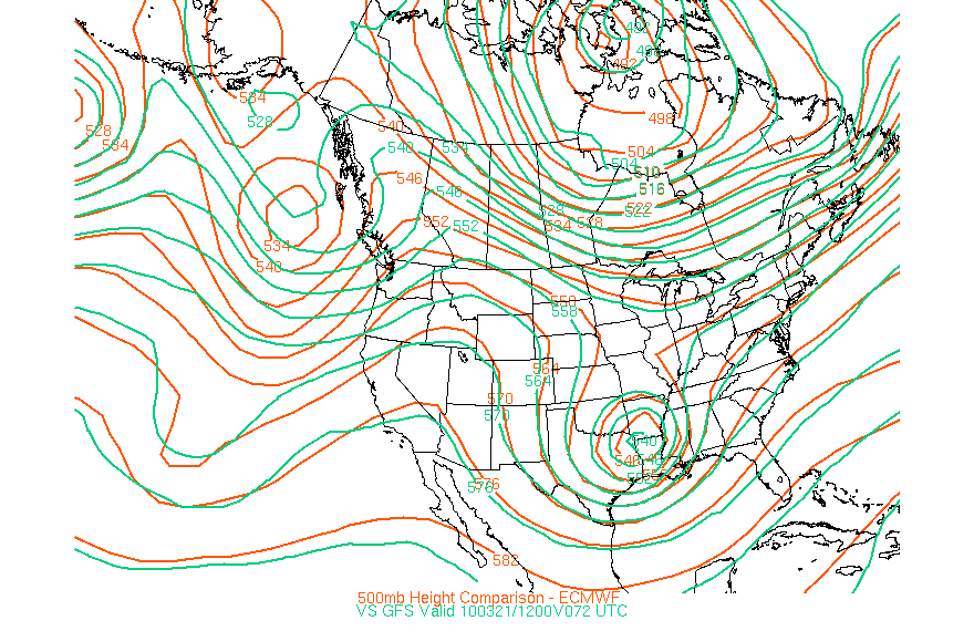
txagwxman wrote:Where is the link for that height comparison?
Here you go txagwxman...
http://www.met.sjsu.edu/weather/ecmwf.html
0 likes
Carla/Alicia/Jerry(In The Eye)/Michelle/Charley/Ivan/Dennis/Katrina/Rita/Wilma/Ike/Harvey
Member: National Weather Association
Wx Infinity Forums
http://wxinfinity.com/index.php
Facebook.com/WeatherInfinity
Twitter @WeatherInfinity
Member: National Weather Association
Wx Infinity Forums
http://wxinfinity.com/index.php
Facebook.com/WeatherInfinity
Twitter @WeatherInfinity
Re: Texas winter wx thread (2009-2010)
Interesting stuff out of FW for this time of year. Given how conservative they are deep in winter lol.
AREA FORECAST DISCUSSION
NATIONAL WEATHER SERVICE FORT WORTH TX
402 PM CDT THU MAR 18 2010
.DISCUSSION...
IT HAS BEEN A VERY NICE DAY ACROSS THE REGION TODAY...BUT MAJOR
CHANGES ARE ON THE WAY AS A POWERFUL UPPER LEVEL SYSTEM WILL
AFFECT NORTH TEXAS THIS WEEKEND. IRONICALLY...SATURDAY WILL BE THE
FIRST DAY OF SPRING...BUT WINTER-LIKE WEATHER WILL REIGN.
THE 12Z UPPER AIR ANALYSIS SHOWED A BETTER DEFINED SHORTWAVE
TROUGH ACROSS THE PACIFIC NW THAN WHAT THE MODELS HAD PREVIOUSLY
FORECAST. WHILE THE PRIMARY POTENTIAL VORTICITY ANOMALY THAT
WILL EVENTUALLY CARVE OUT THE UPPER LOW IS STILL ACROSS BRITISH
COLUMBIA...IT APPEARS THAT THE INITIALIZATION OF THE PAC NW
SHORTWAVE FEATURE HAS CAUSED THE MODELS TO SHIFT THE TRACK OF THE
UPPER LOW FARTHER TO THE SOUTH AND ABOUT 12 HOURS SLOWER AS THE
TWO VORTICITY CENTERS DUMBBELL AROUND EACH OTHER. THE TRACK OF THE
UPPER LOW WILL ULTIMATELY HAVE IMPLICATIONS ON WHETHER WINTRY
PRECIPITATION WILL ACCOMPANY THIS SYSTEM IN NORTH TEXAS.
/TONIGHT THROUGH SUNDAY NIGHT/
THE LIGHT/VARIABLE WINDS TODAY WILL ATTAIN A SOUTHERLY DIRECTION
TONIGHT AND INCREASE FRIDAY IN RESPONSE TO HEIGHT/PRESSURE FALLS
AHEAD OF THE APPROACHING TROUGH. EXPECT GRADUALLY INCREASING
CLOUDS/MOISTURE DURING THE DAY FRIDAY WITH MILD TEMPS. COLD FRONT
WILL ARRIVE INTO THE NW CWA EARLY SATURDAY MORNING...AND RAPIDLY
SWEEP THROUGH THE REMAINDER OF THE CWA BY NOON. 25 TO 35 MPH AND
GUSTY NORTH WINDS BEHIND THE FRONT WILL RESULT IN STRONG COLD
ADVECTION AND TEMPS FALLING INTO THE MID 30S TO LOWER 40S BY
AFTERNOON. CONVECTION IS EXPECTED TO DEVELOP ALONG AND BEHIND THE
FRONT IN RESPONSE TO STRONG FRONTOGENETIC LIFTING. BECAUSE OF THE
FAST MOVING COLD FRONT...CONVECTION SHOULD BE UNDERCUT BY THE
FRONT AND WILL NOT HAVE ACCESS TO SURFACE BASED PARCELS. THIS AND
THE OVERALL WEAK INSTABILITY ENVIRONMENT SHOULD LIMIT ANY SEVERE
WEATHER THREAT. QPF IS EXPECTED TO RUN BETWEEN 0.5 AND 1
INCH...AND THE RAIN SHOULD PRIMARILY BE A MORNING EVENT AND END
FROM WEST TO EAST AS A DRY SLOT MOVES IN.
TEMPERATURES IN THE LOW/MID LEVELS WILL CERTAINLY BE COLD ENOUGH
FOR SNOW OVER THE ENTIRE CWA BY SATURDAY EVENING. WHETHER IT
ACTUALLY DOES SNOW WILL DEPEND ON THE WRAP-AROUND PRECIPITATION
CHANCES AND THUS ESSENTIALLY HOW FAR SOUTH THE UPPER LEVEL LOW
TRACKS. AS MENTIONED...THE MAJORITY OF THE MODELS HAVE SHIFTED
THE TRACK FARTHER SOUTH...WHICH IS PRETTY CLOSE TO THE SOLUTION
THAT THE ECMWF HAS BEEN DEPICTING FOR A COUPLE RUNS NOW. SOME OF
THE MODELS ARE EVEN FARTHER SOUTH...BUT FOR NOW THIS FORECAST WILL
STAY WITH THE CONSENSUS TRACK. HAVE INTRODUCED A MENTION OF SNOW
OVER OVER THE NORTHERN 2 ROWS OF COUNTIES. GIVEN THE MODELS REALLY
HAVE NOT SETTLED ON A TRACK LATITUDE YET...CONFIDENCE IN SNOW IS
LOW AND THUS TOO EARLY TO ENTERTAIN IMPACTS OR ACCUMULATIONS.
REGARDLESS OF SNOW POTENTIAL...MOST OF THE REGION WILL CONTEND
WITH NEAR FREEZING TEMPS SUN MORNING AND AGAIN MONDAY MORNING.
TR.92
/MONDAY THROUGH THURSDAY/
HIGH PRESSURE BEHIND THE FROPA WILL KEEP SKIES CLEAR MONDAY AND
TUESDAY BEFORE WAA PICKS BACK UP BRINGING IN MORE CLOUDS ON
WEDNESDAY. PREFERRED THE ECMWF IN THE LONG TERM DUE TO QUESTIONABLE
SOLUTION BY 12 GFS. GFS DROPS A SURFACE LOW FROM THE TX/OK PANHANDLE
SOUTHWEST TO THE TRANS-PECOS TUESDAY NIGHT WHILE NO OTHER MODEL
HINTS TOWARDS THAT SOLUTION. AS A RESULT...TREATED THE GFS AS AN
OUTLIER AND TRENDED TOWARDS THE ECMWF. 12Z ECMWF PROGS A STRENGTHING
LOW ACROSS OK THURSDAY MORNING AND BRINGS THE ASSOCIATED COLD FRONT
THROUGH NORTH TEXAS ON THURSDAY MORNING. SOME SHOWERS AND ISOLATED
THUNDERSTORMS WILL BE POSSIBLE WEDNEDSAY AFTERNOON THROUGH FROPA ON
THURSDAY MORNING. SHEAR PROFILES LOOK GOOD FOR A FEW SEVERE STORMS
BUT INSTABILITY IS ELEVATED AND THE POSSIBLITY ANY STORMS BECOME
SURFACE BASED APPEARS UNLIKELY AT THIS TIME. 42/MM
0 likes
The above post and any post by Ntxw is NOT an official forecast and should not be used as such. It is just the opinion of the poster and may or may not be backed by sound meteorological data. It is NOT endorsed by any professional institution including Storm2k. For official information, please refer to NWS products.
Help support Storm2K!
Help support Storm2K!
Re: Texas winter wx thread (2009-2010)
HPC snow\ice discussion
Not to compare as storms are all different, but this system has Christmas written all over it based on models.
PROBABILISTIC HEAVY SNOW AND ICING DISCUSSION
NWS HYDROMETEOROLOGICAL PREDICTION CENTER CAMP SPRINGS MD
356 PM EDT THU MAR 18 2010
VALID 00Z FRI MAR 19 2010 - 00Z MON MAR 22 2010
DAY 1...
ROCKIES TO THE CENTRAL PLAINS...
A SHARPENING TROUGH OVER THE INTERIOR WEST WILL ALLOW A STRONG
COLD FRONT TO PLUNGE SWD THRU THE PLAINS AS A POLAR SFC HIGH
BUILDS INTO MT AND THE DAKOTAS ON FRI. A PERIOD OF STRONG POST
FRONTAL LOW LEVEL UPSLOPE FLOW WILL COMBINE WITH THE DIGGING UPPER
ENERGY...RESULTING IN AREAS OF HVY SNOW. 12Z GUIDANCE IS SIMILAR
IN FOCUSING THE HVST SNOW FROM SRN WY TO CNTRL CO....WHERE QPF
TOTALS SUPPORT SOME 8 INCH PLUS SNOW AMTS THRU THE MORE FAVORED
TERRAIN. LIGHTER SNOW SHOULD ALSO SPREAD EWD INTO NE/IA AND NRN
KS AS WEAK ENERGY SHEARS NEWD ON FRI IN THE POST-FRONTAL
ENVIRONMENT.
THE PROBABILITY OF SIGNIFICANT ICING IS LESS THAN 10 PERCENT.
DAYS 2 AND 3...
SRN ROCKIES TO CNTRL/SRN PLAINS...
A LATE WINTER SNOWFALL IS EXPECTED AS ENERGY DIGS INTO THE ACTIVE
SRN JET OVER NM AND TX.
GENERALLY FAVORED A BLEND OF THE ECMWF AND GFS SYNOPTIC PATTERN
AND QPF/PTYPE FIELDS ON D2...AND MOSTLY THE ECMWF ON D3. BOTH
MODELS HAVE TRENDED MORE SUPPRESSED WITH DEVELOPING
SYSTEM...REDUCING THE THREAT FOR WIDESPREAD SNOW OVER NRN KS AND
POINTS NEWD. AXIS OF HVST SNOW IS NOW MOST LIKELY FROM THE SERN
QUARTER OF KS TO NRN/CNTRL OK SAT AND SAT NIGHT....WHERE POTENTIAL
EXISTS FOR LOCALIZED AMTS UP TO 12 INCHES. SNOW SHOULD EXTEND SWD
INTO NORTH TX AS UPPER LOW PASSES OVER THE AREA LATE SAT.
INITIALLY WARM GROUND CONDITIONS ACROSS THE PLAINS WILL RESULT IN
SUBSTANTIAL MELTING AND HELP TO HINDER ACCUMULATIONS. SOME HVY
SNOW IS ALSO EXPECTED FRI NIGHT AND SAT OVER THE SRN ROCKIES AND
HIGH PLAINS...WITH STRONG POST FRONTAL UPSLOPE REACHING INTO THE
MTNS OF SRN CO AND NERN NM. A DEVELOPING COMMA HEAD FEATURE ON
SAT SHOULD BRING A PERIOD OF HEAVIER SNOW EWD ACROSS THE TX/OK
PANHANDLE BEFORE INTENSIFYING OVER THE SRN PLAINS.
THE PROBABILITY OF SIGNIFICANT ICING IS LESS THAN 10 PERCENT.
Not to compare as storms are all different, but this system has Christmas written all over it based on models.
0 likes
The above post and any post by Ntxw is NOT an official forecast and should not be used as such. It is just the opinion of the poster and may or may not be backed by sound meteorological data. It is NOT endorsed by any professional institution including Storm2k. For official information, please refer to NWS products.
Help support Storm2K!
Help support Storm2K!


Blizzard anybody????
Amarillo AFD
.PREV DISCUSSION... /ISSUED 728 PM CDT THU MAR 18 2010/
UPDATE...
AFTER TAKING CLOSER LOOK AT MODELS...IT APPEARS ALL OF THE PANHANDLES
WILL HAVE A VERY GOOD CHANCE FOR SNOW ALONG WITH VERY WINDY
CONDITIONS. NEAR BLIZZARD CONDITIONS EXPECTED ACROSS ALL OF THE
FORECAST AREA FRIDAY AFTERNOON AND FRIDAY NIGHT INTO SATURDAY. WILL
GO AHEAD AN EXTEND THE WINTER STORM WATCH SOUTH TO INCLUDE ALL OF THE
PANHANDLES. LATER SHIFTS MAY POSSIBLY NEED A BLIZZARD WATCH DEPENDING
ON TREND OF 00Z RUNS.
SCHNEIDER/DRILLETTE/JOHNSON
0 likes
Re: Texas winter wx thread (2009-2010)
That's crazy. 
0 likes
The above post and any post by Ntxw is NOT an official forecast and should not be used as such. It is just the opinion of the poster and may or may not be backed by sound meteorological data. It is NOT endorsed by any professional institution including Storm2k. For official information, please refer to NWS products.
Help support Storm2K!
Help support Storm2K!


-
srainhoutx
- S2K Supporter
- Posts: 6919
- Age: 68
- Joined: Sun Jan 14, 2007 11:34 am
- Location: Haywood County, NC
- Contact:
Re: Texas winter wx thread (2009-2010)
Crazy late season winter storm will make for an interesting 24-36 hours...
PROBABILISTIC HEAVY SNOW AND ICING DISCUSSION
NWS HYDROMETEOROLOGICAL PREDICTION CENTER CAMP SPRINGS MD
408 AM EDT FRI MAR 19 2010
VALID 12Z FRI MAR 19 2010 - 12Z MON MAR 22 2010
DAYS 1 TO 2...
...CNTRL/SRN ROCKIES...CENTRAL PLAINS...MID MS VLY...
A SHARPENING TROUGH WILL CONTINUE TO DIG SOUTHEAST THROUGH THE
FOUR CORNERS REGION AND ALLOW A STRONG COLD FRONT TO PLUNGE SOUTH
THRU THE PLAINS AS A POLAR SFC HIGH BUILDS ACROSS THE NORTHERN
PLAINS ON FRI. A PERIOD OF STRONG POST FRONTAL LOW LEVEL UPSLOPE
FLOW WILL COMBINE WITH THE DIGGING UPPER ENERGY/HEIGHT FALLS AS
COLD AIR FILTERS SOUTHWARD...RESULTING IN AREAS OF HVY SNOW. THE
LATEST GUIDANCE IS QUITE CONSISTENT IN DEPICTING HVY
ACCUMULATIONS...INITIALLY OVER NWRN WY AND PARTS OF NERN UT...WITH
THE TETONS AND UINTA RANGES FAVORED...BUT THEN BECOMING MUCH MORE
NOTABLE OVER THE CO HIGH COUNTRY AND DEVELOPING SOUTH DOWN INTO
MUCH OF NRN NM. LESSER...BUT STILL LOCALLY SIGNIFICANT ACCUMS ARE
EXPECTED DOWN THE IMMEDIATE FRONT RANGE AND INTO THE PALMER DIVIDE
AREA AS WELL. LOCALIZED SNOWFALL AMTS IN EXCESS OF 1 FOOT ARE
LIKELY OVER THE HIGH COUNTRY.
MEANWHILE...A HVY LATE WINTER SNOWFALL IS STILL EXPECTED TO EVOLVE
OUT ACROSS THE CNTRL U.S. AS THE AFOREMENTIONED HEIGHT FALLS SLIDE
OUT INTO THE CNTRL/SRN PLAINS ON SAT AND FOSTERS SFC LOW PRESSURE
DEVELOPMENT NEAR THE RED RIVER VLY EARLY SAT AND THEN SLOWLY
ADVANCING NORTHEASTWARD ACROSS CNTRL AR BY SUN MORNING. GENERALLY
FAVORED A BLEND OF THE ECMWF/GFS/UKMET SYNOPTIC PATTERN WITH
QPF/PTYPE FAVORING AN ECMWF/GFS BLEND. THIS REFLECTS A TREND TO BE
A LITTLE SLOWER WITH THE EVOLUTION OF THE STORM SYSTEM VERSUS PREV
FORECAST CYCLES. IN ANY EVENT...RAPIDLY COOLING THERMAL COLUMNS
ASSOC WITH THE HEIGHT FALLS AND LOW LVL COLD AIR ADVECTION
POST-FRONTAL SHOULD ALLOW A STRIPE OF LGT TO MDT SNOW TO INITIALLY
DEVELOP AND STREAK OUT ACROSS THE CNTRL PLAINS ON FRI AND INTO
PORTIONS OF THE MID MS VLY BY EARLY SAT. THIS WILL INCLUDE AN AXIS
FROM N TX/WRN OK NORTHEASTWARD ACROSS CNTRL/WRN KS AND INTO NWRN
MO/SRN IA. HOWEVER...THE HEAVIEST SNOWFALL ACCUMS OVERALL FOR THE
EVENT SHOULD SET UP SAT/SAT NIGHT ALONG A CORRIDOR FROM CNTRL/ERN
OK NORTHEAST INTO SERN KS AND WRN MO AS THE STORM INTENSIFIES
COMING OUT OF THE RED RIVER VLY...AND PROMOTES STG DYNAMIC COOLING
WITHIN THE DEVELOPING COMMA-HEAD. LOCALIZED TOTALS IN EXCESS OF 1
FOOT ARE POSSIBLE...ESP OVER ERN OK WHERE A LOW TO MDT RISK OF 12
INCHES IS ADVERTISED. LESSER AMTS ARE PROGGED FARTHER NORTHEAST
ACROSS NRN IL. THE SNOW SHOULD EXTEND AS FAR SOUTH AS NRN/NERN TX
INVOF THE RED RIVER VLY AS THE UPPER LOW PASSES OVER THE AREA LATE
SAT. INITIALLY WARM GROUND CONDITIONS ACROSS THE PLAINS/MIDWEST
WILL RESULT IN SUBSTANTIAL MELTING AND HELP TO HINDER
ACCUMULATIONS...BUT HVY SNOWFALL RATES AND WATER EQUIVALENTS
SHOULD HELP TO COMPENSATE.
0 likes
Carla/Alicia/Jerry(In The Eye)/Michelle/Charley/Ivan/Dennis/Katrina/Rita/Wilma/Ike/Harvey
Member: National Weather Association
Wx Infinity Forums
http://wxinfinity.com/index.php
Facebook.com/WeatherInfinity
Twitter @WeatherInfinity
Member: National Weather Association
Wx Infinity Forums
http://wxinfinity.com/index.php
Facebook.com/WeatherInfinity
Twitter @WeatherInfinity
Cold front has moved through the panhandle and is on it's way to sweep northwest Texas and southwest Oklahoma. It's wild how the models are spitting out such low thicknesses with this system. 540 just doesn't do it for snow this time of year and what does it do, 534s!
0 likes
The above post and any post by Ntxw is NOT an official forecast and should not be used as such. It is just the opinion of the poster and may or may not be backed by sound meteorological data. It is NOT endorsed by any professional institution including Storm2k. For official information, please refer to NWS products.
Help support Storm2K!
Help support Storm2K!
Re:
gboudx wrote:What's the latest track shown by the models? Same, more south, more north?
It hasn't really changed. The best snow chances if any will be with the wrap around comma head, the closer to the Red River you are the more likely it willl be. How far south that reaches will be determined by strength and track. A lil jog to the south would bring back more moisture, temps look plenty cold enough. As NWS stated less than 100 miles separates nothing to absolute chaos. Personally I do believe I-20 northwards will see at least some flurries, whether it will amount to anything is yet to be seen. GFS puts up to an inch + for the counties lining the Red River.
For East\Southeast Texas' concern, light wrap around precip is shown by the models for a brief period of something possibly there.
For temperatures, a freeze is likely the next couple of nights for the northern half of Texas. Should be down to the mid-30s in central and northern s\e Tx. If the winds let up then a light freeze just north of the immediate Houston area isn't out of the question.
0 likes
The above post and any post by Ntxw is NOT an official forecast and should not be used as such. It is just the opinion of the poster and may or may not be backed by sound meteorological data. It is NOT endorsed by any professional institution including Storm2k. For official information, please refer to NWS products.
Help support Storm2K!
Help support Storm2K!
Who is online
Users browsing this forum: No registered users and 183 guests