SPO: TROPICAL CYCLONE ULUI (13F/20P)

Moderator: S2k Moderators

Message
Author
User avatar
HURAKAN
Professional-Met
Professional-Met
Posts: 46086
Age: 38
Joined: Thu May 20, 2004 4:34 pm
Location: Key West, FL
Contact:

#161 Postby HURAKAN » Wed Mar 17, 2010 5:43 pm

TROPICAL CYCLONE TECHNICAL BULLETIN: AUSTRALIA - EASTERN REGION
Issued by BRISBANE TROPICAL CYCLONE WARNING CENTRE
at: 1844 UTC 17/03/2010
Name: Severe Tropical Cyclone Ului
Identifier: 09U
Data At: 1800 UTC
Latitude: 14.7S
Longitude: 157.8E
Location Accuracy: within 10 nm [20 km]
Movement Towards: south [180 deg]
Speed of Movement: 3 knots [6 km/h]
Maximum 10-Minute Wind: 85 knots [155 km/h]
Maximum 3-Second Wind Gust: 120 knots [220 km/h]
Central Pressure: 952 hPa
Radius of 34-knot winds NE quadrant: 150 nm [280 km]
Radius of 34-knot winds SE quadrant: 150 nm [280 km]
Radius of 34-knot winds SW quadrant: 150 nm [280 km]
Radius of 34-knot winds NW quadrant: 150 nm [280 km]
Radius of 48-knot winds NE quadrant: 60 nm [110 km]
Radius of 48-knot winds SE quadrant: 60 nm [110 km]
Radius of 48-knot winds SW quadrant: 60 nm [110 km]
Radius of 48-knot winds NW quadrant: 60 nm [110 km]
Radius of 64-knot winds: 40 nm [75 km]
Radius of Maximum Winds: 20 nm [35 km]
Dvorak Intensity Code: T5.0/5.0/W0.5/24HRS
Pressure of outermost isobar: 1000 hPa
Radius of outermost closed isobar: 170 nm [315 km]
Storm Depth: Deep
FORECAST DATA
Date/Time : Location : Loc. Accuracy: Max Wind : Central Pressure
[UTC] : degrees : nm [km]: knots[km/h]: hPa
+12: 18/0600: 15.6S 157.8E: 040 [075]: 085 [155]: 953
+24: 18/1800: 16.6S 157.2E: 070 [130]: 090 [165]: 949
+36: 19/0600: 17.7S 155.8E: 100 [190]: 090 [165]: 950
+48: 19/1800: 18.6S 154.0E: 135 [250]: 090 [165]: 947
+60: 20/0600: 19.3S 151.7E: 180 [340]: 090 [165]: 946
+72: 20/1800: 19.9S 149.3E: 230 [425]: 090 [165]: 946
REMARKS:
Cloud tops have remained relatively warm and the system's eye has become larger
and less well defined on IR imagery. Dvorak analysis based on an Eye pattern
DT=5.0 based on MG surround with OW eye and an adjustment for a banding feature.
MET and PT both suggest 5.0. CI reduced to 5.0. The upper level pattern
generally remains favourable with strong poleward outflow associated with an
upper level trough to the south. Possibly the recent weakening trend is due to
ocean upwelling resulting from the slow movement in the past 48 hours.

Steering remains light with forecast slow southerly movement expected in the
next 24 hours. From this time Ului should accelerate and track to the southwest
then to the west southwest towards the Queensland coast on Friday as a mid-level
ridge develops to the south of the system.

Forecast intensity is held at 85 knots [category 3] through Thursday and then
slight reintensification to category 4 is forecast overnight Thursday into
Friday. In general the upper level pattern should remain conducive for Ului to
remain at severe classification through to landfall.

At this stage a severe impact on the Queensland coast is likely later on
Saturday and/or Sunday.

Copyright Commonwealth of Australia
==
The next bulletin for this system will be issued by: 18/0100 UTC by Brisbane
TCWC.


Image
0 likes   

User avatar
HURAKAN
Professional-Met
Professional-Met
Posts: 46086
Age: 38
Joined: Thu May 20, 2004 4:34 pm
Location: Key West, FL
Contact:

#162 Postby HURAKAN » Wed Mar 17, 2010 9:09 pm

Image

Latest
0 likes   

User avatar
HURAKAN
Professional-Met
Professional-Met
Posts: 46086
Age: 38
Joined: Thu May 20, 2004 4:34 pm
Location: Key West, FL
Contact:

#163 Postby HURAKAN » Wed Mar 17, 2010 9:21 pm

TROPICAL CYCLONE TECHNICAL BULLETIN: AUSTRALIA - EASTERN REGION
Issued by BRISBANE TROPICAL CYCLONE WARNING CENTRE
at: 0114 UTC 18/03/2010
Name: Severe Tropical Cyclone Ului
Identifier: 09U
Data At: 0000 UTC
Latitude: 15.0S
Longitude: 157.8E
Location Accuracy: within 10 nm [20 km]
Movement Towards: south southwest [198 deg]
Speed of Movement: 3 knots [6 km/h]
Maximum 10-Minute Wind: 80 knots [150 km/h]
Maximum 3-Second Wind Gust: 110 knots [205 km/h]
Central Pressure: 960 hPa
Radius of 34-knot winds NE quadrant: 150 nm [280 km]
Radius of 34-knot winds SE quadrant: 150 nm [280 km]
Radius of 34-knot winds SW quadrant: 150 nm [280 km]
Radius of 34-knot winds NW quadrant: 150 nm [280 km]
Radius of 48-knot winds NE quadrant: 60 nm [110 km]
Radius of 48-knot winds SE quadrant: 60 nm [110 km]
Radius of 48-knot winds SW quadrant: 60 nm [110 km]
Radius of 48-knot winds NW quadrant: 60 nm [110 km]
Radius of 64-knot winds: 40 nm [75 km]
Radius of Maximum Winds: 25 nm [45 km]
Dvorak Intensity Code: T4.5/5.0/W0.5/12HRS
Pressure of outermost isobar: 1002 hPa
Radius of outermost closed isobar: 180 nm [335 km]
Storm Depth: Deep
FORECAST DATA
Date/Time : Location : Loc. Accuracy: Max Wind : Central Pressure
[UTC] : degrees : nm [km]: knots[km/h]: hPa
+12: 18/1200: 15.8S 157.4E: 040 [075]: 075 [140]: 965
+24: 19/0000: 17.2S 156.2E: 070 [130]: 080 [150]: 962
+36: 19/1200: 18.3S 154.5E: 100 [190]: 080 [150]: 958
+48: 20/0000: 19.2S 152.1E: 135 [250]: 080 [150]: 958
+60: 20/1200: 19.8S 149.7E: 180 [340]: 075 [140]: 962
+72: 21/0000: 20.4S 146.7E: 230 [425]: 060 [110]: 977
REMARKS:
Severe Tropical Cyclone Ului has weakened in the last 24 hours, the eye now
being larger and more ragged with cloud tops remaining relatively warm. Dvorak
analysis based on an Eye pattern DT=4.5 based on DG surround with OW eye. PT
suggest 4.0. FT=4.5 while CI held at 5.0. Intensity of 80 knots consistent with
recent SATCON estimate. The recent weakening trend is most likely due to cooler
sea surface temperatures less than 26C caused by ocean upwelling resulting from
the slow movement in the past 48 hours. Despite this the upper level pattern
generally remains conducinve for development with low wind shear and strong
poleward outflow associated with an upper level trough to the south.

Current steering remains light, although Ului should begin to accelerate and
track more to the southwest in 12 hours then to the west southwest towards the
Queensland coast later on Friday as a mid-level ridge builds to the south of the
system.

Forecast intensity may weaken in the next 6-12 hours but then slight
reintensification could occur as the cyclone accelerates into a region of higher
sea temperatures and a short-wave upper trough to the south assists with upper
outflow. Category 3 intensity is forecast through to landfall, although it is
possible that some weakening is possible just prior to landfall

At this stage a severe impact on the Queensland coast on Sunday morning seems
likely.

Copyright Commonwealth of Australia
==
The next bulletin for this system will be issued by: 18/0700 UTC by Brisbane
TCWC.


Image
0 likes   

User avatar
HURAKAN
Professional-Met
Professional-Met
Posts: 46086
Age: 38
Joined: Thu May 20, 2004 4:34 pm
Location: Key West, FL
Contact:

#164 Postby HURAKAN » Wed Mar 17, 2010 9:22 pm

Image

Image

Latest
0 likes   

User avatar
HURAKAN
Professional-Met
Professional-Met
Posts: 46086
Age: 38
Joined: Thu May 20, 2004 4:34 pm
Location: Key West, FL
Contact:

#165 Postby HURAKAN » Wed Mar 17, 2010 10:34 pm

Image

Continues to degrade
0 likes   

User avatar
HURAKAN
Professional-Met
Professional-Met
Posts: 46086
Age: 38
Joined: Thu May 20, 2004 4:34 pm
Location: Key West, FL
Contact:

#166 Postby HURAKAN » Wed Mar 17, 2010 10:37 pm

Image

WTPS31 PGTW 180300
MSGID/GENADMIN/NAVMARFCSTCEN PEARL HARBOR HI/JTWC//
SUBJ/TROPICAL CYCLONE 20P (ULUI) WARNING NR 014//
RMKS/
1. TROPICAL CYCLONE 20P (ULUI) WARNING NR 014
01 ACTIVE TROPICAL CYCLONE IN SOUTHPAC
MAX SUSTAINED WINDS BASED ON ONE-MINUTE AVERAGE
WIND RADII VALID OVER OPEN WATER ONLY
---
WARNING POSITION:
180000Z --- NEAR 15.0S 157.9E
MOVEMENT PAST SIX HOURS - 200 DEGREES AT 03 KTS
POSITION ACCURATE TO WITHIN 040 NM
POSITION BASED ON CENTER LOCATED BY SATELLITE
PRESENT WIND DISTRIBUTION:
MAX SUSTAINED WINDS - 085 KT, GUSTS 105 KT
WIND RADII VALID OVER OPEN WATER ONLY
RADIUS OF 064 KT WINDS - 050 NM NORTHEAST QUADRANT
050 NM SOUTHEAST QUADRANT
050 NM SOUTHWEST QUADRANT
050 NM NORTHWEST QUADRANT
RADIUS OF 050 KT WINDS - 095 NM NORTHEAST QUADRANT
085 NM SOUTHEAST QUADRANT
085 NM SOUTHWEST QUADRANT
090 NM NORTHWEST QUADRANT
RADIUS OF 034 KT WINDS - 160 NM NORTHEAST QUADRANT
155 NM SOUTHEAST QUADRANT
155 NM SOUTHWEST QUADRANT
145 NM NORTHWEST QUADRANT
REPEAT POSIT: 15.0S 157.9E
---
FORECASTS:
12 HRS, VALID AT:
181200Z --- 16.0S 157.4E
MAX SUSTAINED WINDS - 085 KT, GUSTS 105 KT
WIND RADII VALID OVER OPEN WATER ONLY
RADIUS OF 064 KT WINDS - 050 NM NORTHEAST QUADRANT
050 NM SOUTHEAST QUADRANT
050 NM SOUTHWEST QUADRANT
050 NM NORTHWEST QUADRANT
RADIUS OF 050 KT WINDS - 095 NM NORTHEAST QUADRANT
090 NM SOUTHEAST QUADRANT
085 NM SOUTHWEST QUADRANT
090 NM NORTHWEST QUADRANT
RADIUS OF 034 KT WINDS - 160 NM NORTHEAST QUADRANT
160 NM SOUTHEAST QUADRANT
155 NM SOUTHWEST QUADRANT
155 NM NORTHWEST QUADRANT
VECTOR TO 24 HR POSIT: 225 DEG/ 08 KTS
---
24 HRS, VALID AT:
190000Z --- 17.2S 156.2E
MAX SUSTAINED WINDS - 085 KT, GUSTS 105 KT
WIND RADII VALID OVER OPEN WATER ONLY
RADIUS OF 064 KT WINDS - 050 NM NORTHEAST QUADRANT
050 NM SOUTHEAST QUADRANT
050 NM SOUTHWEST QUADRANT
050 NM NORTHWEST QUADRANT
RADIUS OF 050 KT WINDS - 095 NM NORTHEAST QUADRANT
090 NM SOUTHEAST QUADRANT
090 NM SOUTHWEST QUADRANT
090 NM NORTHWEST QUADRANT
RADIUS OF 034 KT WINDS - 160 NM NORTHEAST QUADRANT
165 NM SOUTHEAST QUADRANT
160 NM SOUTHWEST QUADRANT
155 NM NORTHWEST QUADRANT
VECTOR TO 36 HR POSIT: 240 DEG/ 09 KTS
---
36 HRS, VALID AT:
191200Z --- 18.1S 154.6E
MAX SUSTAINED WINDS - 080 KT, GUSTS 100 KT
WIND RADII VALID OVER OPEN WATER ONLY
RADIUS OF 064 KT WINDS - 045 NM NORTHEAST QUADRANT
045 NM SOUTHEAST QUADRANT
045 NM SOUTHWEST QUADRANT
045 NM NORTHWEST QUADRANT
RADIUS OF 050 KT WINDS - 085 NM NORTHEAST QUADRANT
090 NM SOUTHEAST QUADRANT
090 NM SOUTHWEST QUADRANT
085 NM NORTHWEST QUADRANT
RADIUS OF 034 KT WINDS - 145 NM NORTHEAST QUADRANT
155 NM SOUTHEAST QUADRANT
150 NM SOUTHWEST QUADRANT
145 NM NORTHWEST QUADRANT
VECTOR TO 48 HR POSIT: 250 DEG/ 11 KTS
---
EXTENDED OUTLOOK:
48 HRS, VALID AT:
200000Z --- 18.8S 152.4E
MAX SUSTAINED WINDS - 075 KT, GUSTS 090 KT
WIND RADII VALID OVER OPEN WATER ONLY
RADIUS OF 064 KT WINDS - 040 NM NORTHEAST QUADRANT
040 NM SOUTHEAST QUADRANT
040 NM SOUTHWEST QUADRANT
040 NM NORTHWEST QUADRANT
RADIUS OF 050 KT WINDS - 080 NM NORTHEAST QUADRANT
085 NM SOUTHEAST QUADRANT
085 NM SOUTHWEST QUADRANT
080 NM NORTHWEST QUADRANT
RADIUS OF 034 KT WINDS - 135 NM NORTHEAST QUADRANT
145 NM SOUTHEAST QUADRANT
140 NM SOUTHWEST QUADRANT
135 NM NORTHWEST QUADRANT
VECTOR TO 72 HR POSIT: 260 DEG/ 12 KTS
---
72 HRS, VALID AT:
210000Z --- 19.5S 147.4E
MAX SUSTAINED WINDS - 060 KT, GUSTS 075 KT
WIND RADII VALID OVER OPEN WATER ONLY
RADIUS OF 050 KT WINDS - 070 NM NORTHEAST QUADRANT
075 NM SOUTHEAST QUADRANT
070 NM SOUTHWEST QUADRANT
065 NM NORTHWEST QUADRANT
RADIUS OF 034 KT WINDS - 120 NM NORTHEAST QUADRANT
130 NM SOUTHEAST QUADRANT
120 NM SOUTHWEST QUADRANT
115 NM NORTHWEST QUADRANT
VECTOR TO 96 HR POSIT: 265 DEG/ 09 KTS
---
LONG RANGE OUTLOOK:
NOTE...ERRORS FOR TRACK HAVE AVERAGED NEAR 250 NM
ON DAY 4 AND 350 NM ON DAY 5... AND FOR INTENSITY
NEAR 20 KT EACH DAY.
---
96 HRS, VALID AT:
220000Z --- 19.7S 143.6E
MAX SUSTAINED WINDS - 030 KT, GUSTS 040 KT
WIND RADII VALID OVER OPEN WATER ONLY
DISSIPATED AS A SIGNIFICANT TROPICAL CYCLONE OVER LAND
---
REMARKS:
180300Z POSITION NEAR 15.3S 157.8E.
TROPICAL CYCLONE (TC) 20P (ULUI), LOCATED APPROXIMATELY 705 NM EAST
OF CAIRNS, AUSTRALIA, HAS TRACKED SOUTH-SOUTHWESTWARD AT 03 KNOTS
OVER THE PAST SIX HOURS. THE CURRENT POSITION IS BASED ON RECENT
SATELLITE FIXES FROM PGTW AND ABRF AND THE CURRENT INTENSITY OF 85
KNOTS IS CONSISTENT WITH DVORAK ESTIMATES OF 4.5/5.0 FROM BOTH PGTW
AND ABRF. TC 20P HAS WEAKENED SLIGHTLY OVER THE PAST TWELVE HOURS
UNDER THE INFLUENCE OF INCREASING, THOUGH STILL ONLY MODERATE,
EASTERLY VERTICAL WIND SHEAR AND PASSAGE OVER COOLER WATER UPWELLED
BY THE SLOW-MOVING CYCLONE. AS A SUBTROPICAL RIDGE BUILDS TO THE
SOUTH OVER THE NEXT 12 TO 24 HOURS, TC 20P IS EXPECTED TO TURN
WESTWARD AND ACCELERATE TOWARD THE NORTHEASTERN QUEENSLAND COAST,
MAKING LANDFALL AROUND TAU 72. MOST OF THE NUMERICAL MODEL GUIDANCE
IS IN GOOD AGREEMENT WITH THE CURRENT TRACK FORECAST, WHICH IS CLOSE
TO THE MODEL CONSENSUS. TC 20P SHOULD MAINTAIN INTENSITY OVER THE
NEXT DAY OR SO AS GOOD UPPER LEVEL OUTFLOW COMPETES WITH MODERATE
VERTICAL WIND SHEAR AND PASSAGE OVER COOLER WATER TO INFLUENCE STORM
INTENSITY. THEREAFTER, AN INCREASE IN VERTICAL WIND SHEAR AND A
DECREASE IN POLEWARD OUTFLOW ASSOCIATED WITH THE RIDGE BUILDING TO
THE SOUTH SHOULD RESULT IN SLOW WEAKENING PRIOR TO LANDFALL. MAXIMUM
SIGNIFICANT WAVE HEIGHT AT 180000Z IS 21 FEET. NEXT WARNINGS AT
181500Z AND 190300Z.//
NNNN
0 likes   

User avatar
somethingfunny
ChatStaff
ChatStaff
Posts: 3926
Age: 37
Joined: Thu May 31, 2007 10:30 pm
Location: McKinney, Texas

Re: SPO: TROPICAL CYCLONE ULUI (13F/20P)

#167 Postby somethingfunny » Thu Mar 18, 2010 12:03 am

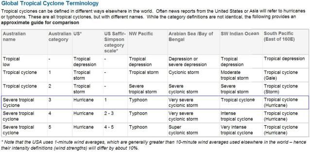
This is a Category Three on the Australian scale, right? What does that translate to on the Saffir-Simpson scale?
0 likes   

User avatar
HURAKAN
Professional-Met
Professional-Met
Posts: 46086
Age: 38
Joined: Thu May 20, 2004 4:34 pm
Location: Key West, FL
Contact:

#168 Postby HURAKAN » Thu Mar 18, 2010 12:51 am

TROPICAL CYCLONE ADVICE NUMBER 1
Issued by the Bureau of Meteorology, Brisbane
Issued at 10:56am EST on Thursday the 18th of March 2010

A Cyclone WATCH has been declared for coastal areas from Cardwell to Yeppoon.


At 10:00 am EST Severe Tropical Cyclone Ului, Category 3 was estimated to be
1140 kilometres northeast of Mackay and
1310 kilometres east of Cairns and
moving south southwest at 6 kilometres per hour.

The cyclone is expected to remain about the same strength.

Severe Tropical Cyclone Ului is expected to begin moving in a southwesterly
direction tonight towards the Queensland coast.

On current predictions the most likely scenario is for the cyclone to cross the
coast Sunday morning between Cardwell and Mackay. However, it is important to
understand that some uncertainty remains in this outlook period.

DAMAGING winds should develop between Cardwell and Yeppoon during Saturday as
the cyclone approaches the coast.

The windy conditions over much of the Queensland east coastal waters will
continue due to the tight pressure gradient generated by a combination of a high
pressure system situated in the Tasman Sea and Severe Tropical Cyclone Ului.
Seas and swell are expected to increase along much of the Queensland east coast
and produce dangerous surf conditions on the exposed coasts.

People between Cardwell and Yeppoon should consider what action they will need
to take if the cyclone threat increases. If you are unsure about the actions to
be taken, information is available from your local government or local State
Emergency Service.

Details of Severe Tropical Cyclone Ului at 10:00 am EST:
.Centre located near...... 15.0 degrees South 157.8 degrees East
.Location accuracy........ within 20 kilometres
.Recent movement.......... towards the south southwest at 6 kilometres per hour
.Wind gusts near centre... 205 kilometres per hour
.Severity category........ 3
.Central pressure......... 960 hectoPascals

Please ensure that neighbours have heard and understood this message,
particularly new arrivals or those who may not fully understand English.

The next advice will be issued by 5:00 pm EST Thursday 18 March.

This warning is also available through TV and Radio Broadcasts; the Bureau's
website at http://www.bom.gov.au or call 1300 659 212. The Bureau and the State
Emergency Service would appreciate this warning being broadcast regularly.


Image
0 likes   

User avatar
HURAKAN
Professional-Met
Professional-Met
Posts: 46086
Age: 38
Joined: Thu May 20, 2004 4:34 pm
Location: Key West, FL
Contact:

Re: SPO: TROPICAL CYCLONE ULUI (13F/20P)

#169 Postby HURAKAN » Thu Mar 18, 2010 12:54 am

somethingfunny wrote:This is a Category Three on the Australian scale, right? What does that translate to on the Saffir-Simpson scale?


Category 1.

http://www.bom.gov.au/weather/cyclone/a ... sity.shtml
0 likes   

User avatar
HURAKAN
Professional-Met
Professional-Met
Posts: 46086
Age: 38
Joined: Thu May 20, 2004 4:34 pm
Location: Key West, FL
Contact:

#170 Postby HURAKAN » Thu Mar 18, 2010 7:57 am

TROPICAL CYCLONE ADVICE NUMBER 3
Issued by the Bureau of Meteorology, Brisbane
Issued at 10:35pm EST on Thursday the 18th of March 2010

A Cyclone WATCH has been declared for coastal areas from Cardwell to Yeppoon.


At 10:00 pm EST Severe Tropical Cyclone Ului, Category 3 was estimated to be
1090 kilometres northeast of Mackay and 1220 kilometres east northeast of
Townsville and is moving south at 7 kilometres per hour.

The cyclone is expected to remain at about the same strength.

Severe Tropical Cyclone Ului is expected to begin moving in a southwesterly
direction during the morning, towards the Queensland coast.

On current predictions the most likely scenario is for the cyclone to cross the
coast Sunday morning between Cardwell and Mackay. However, it is important to
understand that some uncertainty remains in this outlook period.

DAMAGING winds should develop between Cardwell and Yeppoon during Saturday, and
increasing further on Saturday night as the cyclone approaches the coast.

The windy conditions over much of the Queensland east coastal waters will
continue due to the tight pressure gradient generated by a combination of a high
pressure system situated in the Tasman Sea and Severe Tropical Cyclone Ului.
Seas and swell are expected to increase along much of the Queensland east coast
and produce dangerous surf conditions on the exposed coasts.

People between Cardwell and Yeppoon should consider what action they will need
to take if the cyclone threat increases.
- Information is available from your local government
- For cyclone preparedness and safety advice, visit Queensland's Disaster
Management Services
website [www.disaster.qld.gov.au].
- For emergency assistance call the Queensland State Emergency Service [SES] on
132 500 [for assistance with storm damage, rising flood water, fallen trees on
buildings or roof damage]

Details of Severe Tropical Cyclone Ului at 10:00 pm EST:
.Centre located near...... 15.7 degrees South 157.7 degrees East
.Location accuracy........ within 20 kilometres
.Recent movement.......... towards the south at 7 kilometres per hour
.Wind gusts near centre... 185 kilometres per hour
.Severity category........ 3
.Central pressure......... 970 hectoPascals

Please ensure that neighbours have heard and understood this message,
particularly new arrivals or those who may not fully understand English.

The next advice will be issued by 5:00 am EST Friday 19 March.

This warning is also available through TV and Radio Broadcasts; the Bureau's
website at http://www.bom.gov.au or call 1300 659 212. The Bureau and the State
Emergency Service would appreciate this warning being broadcast regularly.


Image
0 likes   

User avatar
HURAKAN
Professional-Met
Professional-Met
Posts: 46086
Age: 38
Joined: Thu May 20, 2004 4:34 pm
Location: Key West, FL
Contact:

#171 Postby HURAKAN » Thu Mar 18, 2010 8:01 am

Image

A ghost of what it used to be
0 likes   

User avatar
alan1961
Category 2
Category 2
Posts: 771
Joined: Mon Mar 20, 2006 11:58 am
Location: Derby, Derbyshire, England
Contact:

Re:

#172 Postby alan1961 » Thu Mar 18, 2010 8:17 am

HURAKAN wrote:Image

A ghost of what it used to be


Yes Hurakan and it makes you think wether it will approach
the Queensland coast with any circulation still intact, seems
to be going downhill pretty quickly, a tighter forecasted pressure
gradient to its south west over the next few days may pep it up a little.
0 likes   

User avatar
HURAKAN
Professional-Met
Professional-Met
Posts: 46086
Age: 38
Joined: Thu May 20, 2004 4:34 pm
Location: Key West, FL
Contact:

#173 Postby HURAKAN » Thu Mar 18, 2010 8:31 am

18/0830 UTC 15.5S 157.7E T4.0/4.0 ULUI -- Southwest Pacific

65 knots
0 likes   

User avatar
HURAKAN
Professional-Met
Professional-Met
Posts: 46086
Age: 38
Joined: Thu May 20, 2004 4:34 pm
Location: Key West, FL
Contact:

#174 Postby HURAKAN » Thu Mar 18, 2010 8:32 am

TROPICAL CYCLONE TECHNICAL BULLETIN: AUSTRALIA - EASTERN REGION
Issued by BRISBANE TROPICAL CYCLONE WARNING CENTRE
at: 1232 UTC 18/03/2010
Name: Severe Tropical Cyclone Ului
Identifier: 09U
Data At: 1200 UTC
Latitude: 15.7S
Longitude: 157.7E
Location Accuracy: within 10 nm [20 km]
Movement Towards: south [188 deg]
Speed of Movement: 4 knots [7 km/h]
Maximum 10-Minute Wind: 75 knots [140 km/h]
Maximum 3-Second Wind Gust: 100 knots [185 km/h]
Central Pressure: 970 hPa
Radius of 34-knot winds NE quadrant: 150 nm [280 km]
Radius of 34-knot winds SE quadrant: 150 nm [280 km]
Radius of 34-knot winds SW quadrant: 150 nm [280 km]
Radius of 34-knot winds NW quadrant: 150 nm [280 km]
Radius of 48-knot winds NE quadrant: 60 nm [110 km]
Radius of 48-knot winds SE quadrant: 60 nm [110 km]
Radius of 48-knot winds SW quadrant: 60 nm [110 km]
Radius of 48-knot winds NW quadrant: 60 nm [110 km]
Radius of 64-knot winds: 40 nm [75 km]
Radius of Maximum Winds: 25 nm [45 km]
Dvorak Intensity Code: T4.0/4.5/W1.0/24HRS
Pressure of outermost isobar: 1004 hPa
Radius of outermost closed isobar: 200 nm [370 km]
Storm Depth: Deep
FORECAST DATA
Date/Time : Location : Loc. Accuracy: Max Wind : Central Pressure
[UTC] : degrees : nm [km]: knots[km/h]: hPa
+12: 19/0000: 17.0S 156.8E: 040 [075]: 075 [140]: 968
+24: 19/1200: 18.2S 155.2E: 070 [130]: 075 [140]: 970
+36: 20/0000: 19.0S 152.8E: 100 [190]: 075 [140]: 964
+48: 20/1200: 19.6S 150.2E: 135 [250]: 075 [140]: 970
+60: 21/0000: 19.9S 147.4E: 180 [340]: 060 [110]: 977
+72: 21/1200: 20.2S 144.9E: 230 [425]: 040 [075]: 990
REMARKS:
Severe Tropical Cyclone Ului has weakened in the last 24 hours, the eye now
being larger and more ragged with cloud tops remaining relatively warm. Dvorak
analysis based on an Eye pattern DT=4.0-4.5 based on OW to DG surround with OW
eye. PT suggest 4.0. FT=4.0 while CI at 4.5. The recent weakening trend is most
likely due to cooler sea surface temperatures less than 26C caused by ocean
upwelling resulting from the slow movement in the past 48 hours. Models indicate
upper conditions will become more favourable by Saturday for increased venting
and deepening.

Following a prolonged period of light steering, a mid-level ridge is beginning
to develop south of the system and Ului should begin to accelerate and track
more to the southwest in the next 24 hours then to the west southwest towards
the Queensland coast later on Friday.

Copyright Commonwealth of Australia
==
The next bulletin for this system will be issued by: 18/1900 UTC by Brisbane
TCWC.
0 likes   

User avatar
HURAKAN
Professional-Met
Professional-Met
Posts: 46086
Age: 38
Joined: Thu May 20, 2004 4:34 pm
Location: Key West, FL
Contact:

#175 Postby HURAKAN » Thu Mar 18, 2010 9:28 am

Image

WTPS31 PGTW 181500
MSGID/GENADMIN/NAVMARFCSTCEN PEARL HARBOR HI/JTWC//
SUBJ/TROPICAL CYCLONE 20P (ULUI) WARNING NR 015//
RMKS/
1. TROPICAL CYCLONE 20P (ULUI) WARNING NR 015
01 ACTIVE TROPICAL CYCLONE IN SOUTHPAC
MAX SUSTAINED WINDS BASED ON ONE-MINUTE AVERAGE
WIND RADII VALID OVER OPEN WATER ONLY
---
WARNING POSITION:
181200Z --- NEAR 15.6S 157.7E
MOVEMENT PAST SIX HOURS - 180 DEGREES AT 02 KTS
POSITION ACCURATE TO WITHIN 060 NM
POSITION BASED ON CENTER LOCATED BY SATELLITE
PRESENT WIND DISTRIBUTION:
MAX SUSTAINED WINDS - 080 KT, GUSTS 100 KT
WIND RADII VALID OVER OPEN WATER ONLY
RADIUS OF 064 KT WINDS - 045 NM NORTHEAST QUADRANT
045 NM SOUTHEAST QUADRANT
045 NM SOUTHWEST QUADRANT
045 NM NORTHWEST QUADRANT
RADIUS OF 050 KT WINDS - 085 NM NORTHEAST QUADRANT
085 NM SOUTHEAST QUADRANT
080 NM SOUTHWEST QUADRANT
080 NM NORTHWEST QUADRANT
RADIUS OF 034 KT WINDS - 155 NM NORTHEAST QUADRANT
155 NM SOUTHEAST QUADRANT
145 NM SOUTHWEST QUADRANT
145 NM NORTHWEST QUADRANT
REPEAT POSIT: 15.6S 157.7E
---
FORECASTS:
12 HRS, VALID AT:
190000Z --- 17.0S 156.5E
MAX SUSTAINED WINDS - 080 KT, GUSTS 100 KT
WIND RADII VALID OVER OPEN WATER ONLY
RADIUS OF 064 KT WINDS - 045 NM NORTHEAST QUADRANT
045 NM SOUTHEAST QUADRANT
045 NM SOUTHWEST QUADRANT
045 NM NORTHWEST QUADRANT
RADIUS OF 050 KT WINDS - 085 NM NORTHEAST QUADRANT
085 NM SOUTHEAST QUADRANT
080 NM SOUTHWEST QUADRANT
080 NM NORTHWEST QUADRANT
RADIUS OF 034 KT WINDS - 155 NM NORTHEAST QUADRANT
155 NM SOUTHEAST QUADRANT
145 NM SOUTHWEST QUADRANT
145 NM NORTHWEST QUADRANT
VECTOR TO 24 HR POSIT: 235 DEG/ 10 KTS
---
24 HRS, VALID AT:
191200Z --- 18.1S 154.8E
MAX SUSTAINED WINDS - 080 KT, GUSTS 100 KT
WIND RADII VALID OVER OPEN WATER ONLY
RADIUS OF 064 KT WINDS - 045 NM NORTHEAST QUADRANT
045 NM SOUTHEAST QUADRANT
045 NM SOUTHWEST QUADRANT
045 NM NORTHWEST QUADRANT
RADIUS OF 050 KT WINDS - 085 NM NORTHEAST QUADRANT
085 NM SOUTHEAST QUADRANT
080 NM SOUTHWEST QUADRANT
080 NM NORTHWEST QUADRANT
RADIUS OF 034 KT WINDS - 155 NM NORTHEAST QUADRANT
155 NM SOUTHEAST QUADRANT
155 NM SOUTHWEST QUADRANT
145 NM NORTHWEST QUADRANT
VECTOR TO 36 HR POSIT: 255 DEG/ 12 KTS
---
36 HRS, VALID AT:
200000Z --- 18.8S 152.4E
MAX SUSTAINED WINDS - 080 KT, GUSTS 100 KT
WIND RADII VALID OVER OPEN WATER ONLY
RADIUS OF 064 KT WINDS - 040 NM NORTHEAST QUADRANT
040 NM SOUTHEAST QUADRANT
040 NM SOUTHWEST QUADRANT
040 NM NORTHWEST QUADRANT
RADIUS OF 050 KT WINDS - 075 NM NORTHEAST QUADRANT
085 NM SOUTHEAST QUADRANT
085 NM SOUTHWEST QUADRANT
075 NM NORTHWEST QUADRANT
RADIUS OF 034 KT WINDS - 140 NM NORTHEAST QUADRANT
150 NM SOUTHEAST QUADRANT
150 NM SOUTHWEST QUADRANT
140 NM NORTHWEST QUADRANT
VECTOR TO 48 HR POSIT: 255 DEG/ 12 KTS
---
EXTENDED OUTLOOK:
48 HRS, VALID AT:
201200Z --- 19.4S 149.9E
MAX SUSTAINED WINDS - 075 KT, GUSTS 090 KT
WIND RADII VALID OVER OPEN WATER ONLY
RADIUS OF 064 KT WINDS - 035 NM NORTHEAST QUADRANT
035 NM SOUTHEAST QUADRANT
035 NM SOUTHWEST QUADRANT
035 NM NORTHWEST QUADRANT
RADIUS OF 050 KT WINDS - 070 NM NORTHEAST QUADRANT
080 NM SOUTHEAST QUADRANT
080 NM SOUTHWEST QUADRANT
070 NM NORTHWEST QUADRANT
RADIUS OF 034 KT WINDS - 135 NM NORTHEAST QUADRANT
145 NM SOUTHEAST QUADRANT
145 NM SOUTHWEST QUADRANT
135 NM NORTHWEST QUADRANT
VECTOR TO 72 HR POSIT: 265 DEG/ 11 KTS
---
72 HRS, VALID AT:
211200Z --- 19.8S 145.1E
MAX SUSTAINED WINDS - 040 KT, GUSTS 050 KT
WIND RADII VALID OVER OPEN WATER ONLY
DISSIPATING AS A SIGNIFICANT TROPICAL CYCLONE OVER LAND
VECTOR TO 96 HR POSIT: 275 DEG/ 11 KTS
---
LONG RANGE OUTLOOK:
NOTE...ERRORS FOR TRACK HAVE AVERAGED NEAR 250 NM
ON DAY 4 AND 350 NM ON DAY 5... AND FOR INTENSITY
NEAR 20 KT EACH DAY.
---
96 HRS, VALID AT:
221200Z --- 19.2S 140.5E
MAX SUSTAINED WINDS - 030 KT, GUSTS 040 KT
WIND RADII VALID OVER OPEN WATER ONLY
DISSIPATED AS A SIGNIFICANT TROPICAL CYCLONE OVER LAND
---
REMARKS:
181500Z POSITION NEAR 15.9S 157.4E.
TROPICAL CYCLONE (TC) 20P (ULUI), LOCATED APPROXIMATELY 670 NM EAST
OF CAIRNS, AUSTRALIA, HAS TRACKED SOUTHWARD AT 02 KNOTS OVER THE
PAST SIX HOURS. ANIMATED INFRARED SATELLITE IMAGERY SHOWS A DECREASE
IN CONVECTION ESPECIALLY IN THE NORTHERN PERIPHERY. INITIAL POSITION
IS BASED ON A SATELLITE IMAGERY FIX FROM PGTW AND INITIAL INTENSITY
IS BASED ON PGTW AND ABRF DVORAK INTENSITY ESTIMATES OF 80 KNOTS.
UPPER LEVEL ANALYSIS INDICATES TC 20P IS LOCATED POLEWARD OF THE
SUBTROPICAL RIDGE (STR) AXIS IN AN AREA OF 20 KNOT VERTICAL WIND
SHEAR (VWS). A MID-LATITUDE TROUGH LOCATED TO THE SOUTHEAST
CONTINUES TO PROVIDE GOOD POLEWARD OUTFLOW. TC 20P IS CURRENTLY
TRACKING SOUTHWARD ON THE WESTERN PERIPHERY OF A NEAR EQUATORIAL
RIDGE. AS A STR BUILDS IN TO THE SOUTH WITHIN THE NEXT 12 HOURS,
ULUI IS EXPECTED TO TURN SOUTHWESTWARD AND BEGIN TO ACCELERATE. TC
20P SHOULD MAKE LANDFALL ON THE NORTHEASTERN QUEENSLAND COAST BY TAU
72 AND THEN WEAKEN SIGNIFICANTLY OVER LAND. VWS SHOULD DECREASE AS
THE STR BUILDS TO THE SOUTH ALLOWING TC 20P TO MAINTAIN CONSTANT
INTENSITIES PRIOR TO LANDFALL. THIS FORECAST IS IN VERY GOOD
AGREEMENT WITH THE PREVIOUS FORECAST AND THE NUMERICAL MODEL
CONSENSUS. MAXIMUM SIGNIFICANT WAVE HEIGHT AT 181200Z IS 26 FEET.
NEXT WARNINGS AT 190300Z AND 191500Z.//
NNNN
0 likes   

User avatar
KWT
Category 5
Category 5
Posts: 31415
Joined: Tue Aug 17, 2004 11:02 am
Location: UK!!!

#176 Postby KWT » Thu Mar 18, 2010 9:48 am

Will be interesting to see what happens to the system once it finally kicks off to the west, either way a landfall of 75-80kts is still quite signifcant, esp if it hits a populated area.
0 likes   
Personal Forecast Disclaimer:
The posts in this forum are NOT official forecast and should not be used as such. They are just the opinion of the poster and may or may not be backed by sound meteorological data. They are NOT endorsed by any professional institution or storm2k.org. For official information, please refer to the NHC and NWS products

Mathew
Tropical Wave
Tropical Wave
Posts: 3
Joined: Thu Mar 18, 2010 10:31 am

#177 Postby Mathew » Thu Mar 18, 2010 10:41 am

I'm sorry Hurakan, but you are mistaken, you may have confused MPH with KMPH, Because STC Ului is a CAT 3 on the Saffir-Simpson scale, or our Australian scale.

CATEGORY 3 (severe tropical cyclone)
Some roof and structural damage. Some caravans destroyed. Power failures likely.
A Category 3 cyclone's strongest winds are VERY DESTRUCTIVE winds with typical gusts over open flat land of 165 - 224 km/h.
These winds correspond to the highest category on the Beaufort scale, Beaufort 12 (Hurricane).
0 likes   

Mathew
Tropical Wave
Tropical Wave
Posts: 3
Joined: Thu Mar 18, 2010 10:31 am

#178 Postby Mathew » Thu Mar 18, 2010 10:47 am

I found this on the Saffir - Simpson scale for you.

Category 3
Sustained winds 50–58 m/s 96–113 kt
Jeanne over the Bahamas
178–209 km/h 111–130 mph
Storm surge 2.7–3.7 m 9–12 ft
Central pressure 945–964 mbar 27.91–28.47 inHg
Tropical cyclones of Category 3 and higher are described as major hurricanes in the Atlantic or Eastern Pacific basins. These storms can cause some structural damage to small residences and utility buildings, particularly those of wood frame or manufactured materials with minor curtainwall failures. Buildings that lack a solid foundation, such as mobile homes, are usually destroyed, and gable-end roofs are peeled off. Manufactured homes usually sustain severe and irreparable damage. Flooding near the coast destroys smaller structures, while larger structures are struck by floating debris. Additionally, terrain may be flooded well inland.[10]
Examples of storms of this intensity include Carol (1954), Alma (1966), Alicia (1983), Fran (1996), Isidore (2002), Jeanne (2004), Lane (2006), and Bertha (2008).
0 likes   

User avatar
HURAKAN
Professional-Met
Professional-Met
Posts: 46086
Age: 38
Joined: Thu May 20, 2004 4:34 pm
Location: Key West, FL
Contact:

#179 Postby HURAKAN » Thu Mar 18, 2010 12:31 pm

The Aussie scale says that a Cat 3 is comparable to a Category 1 in the Saffir-Simpson scale. Did you look into the link I posted?

Image

Link : http://www.bom.gov.au/weather/cyclone/a ... sity.shtml
0 likes   

User avatar
HURAKAN
Professional-Met
Professional-Met
Posts: 46086
Age: 38
Joined: Thu May 20, 2004 4:34 pm
Location: Key West, FL
Contact:

#180 Postby HURAKAN » Thu Mar 18, 2010 12:35 pm

Image

Latest
0 likes   


Return to “2010”

Who is online

Users browsing this forum: No registered users and 0 guests