Issued by BRISBANE TROPICAL CYCLONE WARNING CENTRE
at: 1844 UTC 17/03/2010
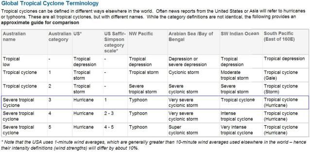
Name: Severe Tropical Cyclone Ului
Identifier: 09U
Data At: 1800 UTC
Latitude: 14.7S
Longitude: 157.8E
Location Accuracy: within 10 nm [20 km]
Movement Towards: south [180 deg]
Speed of Movement: 3 knots [6 km/h]
Maximum 10-Minute Wind: 85 knots [155 km/h]
Maximum 3-Second Wind Gust: 120 knots [220 km/h]
Central Pressure: 952 hPa
Radius of 34-knot winds NE quadrant: 150 nm [280 km]
Radius of 34-knot winds SE quadrant: 150 nm [280 km]
Radius of 34-knot winds SW quadrant: 150 nm [280 km]
Radius of 34-knot winds NW quadrant: 150 nm [280 km]
Radius of 48-knot winds NE quadrant: 60 nm [110 km]
Radius of 48-knot winds SE quadrant: 60 nm [110 km]
Radius of 48-knot winds SW quadrant: 60 nm [110 km]
Radius of 48-knot winds NW quadrant: 60 nm [110 km]
Radius of 64-knot winds: 40 nm [75 km]
Radius of Maximum Winds: 20 nm [35 km]
Dvorak Intensity Code: T5.0/5.0/W0.5/24HRS
Pressure of outermost isobar: 1000 hPa
Radius of outermost closed isobar: 170 nm [315 km]
Storm Depth: Deep
FORECAST DATA
Date/Time : Location : Loc. Accuracy: Max Wind : Central Pressure
[UTC] : degrees : nm [km]: knots[km/h]: hPa
+12: 18/0600: 15.6S 157.8E: 040 [075]: 085 [155]: 953
+24: 18/1800: 16.6S 157.2E: 070 [130]: 090 [165]: 949
+36: 19/0600: 17.7S 155.8E: 100 [190]: 090 [165]: 950
+48: 19/1800: 18.6S 154.0E: 135 [250]: 090 [165]: 947
+60: 20/0600: 19.3S 151.7E: 180 [340]: 090 [165]: 946
+72: 20/1800: 19.9S 149.3E: 230 [425]: 090 [165]: 946
REMARKS:
Cloud tops have remained relatively warm and the system's eye has become larger
and less well defined on IR imagery. Dvorak analysis based on an Eye pattern
DT=5.0 based on MG surround with OW eye and an adjustment for a banding feature.
MET and PT both suggest 5.0. CI reduced to 5.0. The upper level pattern
generally remains favourable with strong poleward outflow associated with an
upper level trough to the south. Possibly the recent weakening trend is due to
ocean upwelling resulting from the slow movement in the past 48 hours.
Steering remains light with forecast slow southerly movement expected in the
next 24 hours. From this time Ului should accelerate and track to the southwest
then to the west southwest towards the Queensland coast on Friday as a mid-level
ridge develops to the south of the system.
Forecast intensity is held at 85 knots [category 3] through Thursday and then
slight reintensification to category 4 is forecast overnight Thursday into
Friday. In general the upper level pattern should remain conducive for Ului to
remain at severe classification through to landfall.
At this stage a severe impact on the Queensland coast is likely later on
Saturday and/or Sunday.
Copyright Commonwealth of Australia
==
The next bulletin for this system will be issued by: 18/0100 UTC by Brisbane
TCWC.


