AREA FORECAST DISCUSSION
NATIONAL WEATHER SERVICE NORMAN OK
656 PM CST SUN JAN 24 2010
.DISCUSSION...
MADE ADJUSTMENTS ON THIS EVENING FORECAST /BRIEF LIGHT RAIN OVER
WESTERN NORTH TEXAS/ AND ALSO ON BIG STORM HEADED OUR WAY FOR
WEDNESDAY- THURSDAY NEXT WEEK. MODEL AGREEMENT IS FAIRLY GOOD WITH
POTENTIAL FOR FAIRLY SUBSTANTIAL WINTER STORM. HOWEVER...THIS FAR
OUT...THERE WILL LIKELY BE SOME CHANGES WITH TIMING AND EXACT
TRACK OF UPPER SYSTEM/ARRIVAL OF COLDER AIR. LEFT MIXES IN THERE
WHERE CONFIDENCE IS NOT SO HIGH...BUT AT THIS TIME...FORECAST DATA
INDICATES THAT THE DOMINANT PRECIP TYPE WILL BE RAIN AND
SNOW...WITH HEAVY ACCUMS LIKELY. STAY TUNED.
Southern Plains winter wx thread (2009-2010)
Moderator: S2k Moderators
Forum rules
 The posts in this forum are NOT official forecast and should not be used as such. They are just the opinion of the poster and may or may not be backed by sound meteorological data. They are NOT endorsed by any professional institution or STORM2K.

The posts in this forum are NOT official forecast and should not be used as such. They are just the opinion of the poster and may or may not be backed by sound meteorological data. They are NOT endorsed by any professional institution or STORM2K.
-
Extremeweatherguy

- Category 5

- Posts: 11095
- Joined: Mon Oct 10, 2005 8:13 pm
- Location: Florida
NWS in Norman just upped their wording big time...
0 likes

-
Extremeweatherguy
- Category 5
- Posts: 11095
- Joined: Mon Oct 10, 2005 8:13 pm
- Location: Florida
-
Extremeweatherguy
- Category 5
- Posts: 11095
- Joined: Mon Oct 10, 2005 8:13 pm
- Location: Florida
Big differences between the 00z NAM and the 00z GFS tonight with regards to the placement of the surface low..
GFS - 84 hrs

NAM - 84 hrs

The NAM places the surface low near the red river, while the GFS places the surface low in central Texas.
By the way, to compare to the December 24th event, here is a look at the placement of that low: http://i43.photobucket.com/albums/e371/ ... 19_3-1.jpg
It seems to have been in between the current NAM and GFS scenarios.
GFS - 84 hrs
NAM - 84 hrs
The NAM places the surface low near the red river, while the GFS places the surface low in central Texas.
By the way, to compare to the December 24th event, here is a look at the placement of that low: http://i43.photobucket.com/albums/e371/ ... 19_3-1.jpg
It seems to have been in between the current NAM and GFS scenarios.
Last edited by Extremeweatherguy on Sun Jan 24, 2010 11:47 pm, edited 1 time in total.
0 likes

Not being picky and choosy but the GFS is closer to the EC. NAM is still in it's long range, interesting though.
0 likes
The above post and any post by Ntxw is NOT an official forecast and should not be used as such. It is just the opinion of the poster and may or may not be backed by sound meteorological data. It is NOT endorsed by any professional institution including Storm2k. For official information, please refer to NWS products.
Help support Storm2K!
-
Extremeweatherguy
- Category 5
- Posts: 11095
- Joined: Mon Oct 10, 2005 8:13 pm
- Location: Florida
AREA FORECAST DISCUSSION
NATIONAL WEATHER SERVICE NORMAN OK
433 AM CST MON JAN 25 2010
.DISCUSSION...
STRONG WINDS WILL BE THE MAIN CONCERN FOR TODAY ACROSS PARTS OF THE
FA. ANOTHER IMPULSE IS EXPECTED TO ROTATE AROUND THE WEST SIDE OF
THE UPPER TROUGH OVER THE CENTRAL PLAINS TODAY. STRONG WINDS OFF THE
DECK WITH H85 WINDS OF 40 TO 50 KTS IN NRN PARTS OF THE FA. FAIRLY
GOOD MIXING EXPECTED AGAIN TODAY AND WILL GO WITH WIND ADVY FOR NRN
PARTS OF THE FA TODAY. EXPECT WINDS TO DROP OFF FAIRLY QUICKLY THIS
EVENING AS AMS DECOUPLES. FOCUS THEN SHIFTS TO POTENTIAL WINTER
STORM EXPECTED TO IMPACT THE AREAS MIDWEEK. SOME LIGHT RAIN
WILL BE POSSIBLE WEDNESDAY WITH DEVELOPING WAA AS UPPER TROUGH MOVES
INTO THE SOUTHWESTERN U.S. WILL TREND FORECAST TOWARD THE SLOWER
ECMWF SOLUTION WHICH HAS SHOWN GOOD RUN TO RUN CONSISTENCY. COLD
FRONT IS EXPECTED TO SURGE SOUTHWARD INTO THE AREA WEDNESDAY NIGHT.
LATER RUNS HAVE SHOWN LOW LEVEL COLD AIR SURGING FARTHER SOUTH AHEAD
OF THE SYSTEM WHICH WHICH COULD LEAD TO A PERIOD FREEZING
PRECIPITATION BEFORE COLD AIR DEEPENS AND PRECIP CHANGES OVER TO
SLEET AND SNOW. FOR NOW WILL BRING WINTRY PRECIP INTO ABOUT THE NW
HALF OF THE WEDNESDAY NIGHT AND THEN SPREAD IT SOUTHEASTWARD ACROSS
THE REMAINDER OF THE FA DURING THE DAY THURSDAY. BY LATE
THURSDAY/THURSDAY NIGHT ALL SNOW EXPECTED AS SYSTEM BEGINS TO EXIT
THE AREA. STILL UNCERTAINTIES WITH THE EVOLUTION OF THE SYSTEM
THIS FAR OUT...BUT IT LOOKS LIKE SIGNIFICANT SNOW/ICE WILL BE
POSSIBLE FOR PARTS OF THE FA WITH THIS STORM.
AREA FORECAST DISCUSSION
NATIONAL WEATHER SERVICE TULSA OK
344 AM CST MON JAN 25 2010
.DISCUSSION...
MOST IMPORTANT PART OF THIS FORECAST IS THE IMPENDING WINTER
STORM FROM WEDNESDAY NIGHT INTO THURSDAY NIGHT.
IN THE MEAN TIME WILL HAVE A FEW RELATIVELY PLEASANT DAYS IF
YOU DO NOT MIND GUSTY WINDS TODAY. TEMPERATURES THE NEXT FEW
DAYS WILL BE BELOW THE GFS GUIDANCE WHILE TEMPERATURES WEDNESDAY
WILL BE ABOVE IT.
RAIN CHANCE BEGIN WEDNESDAY AS DOES INCREASED CLOUD COVER.
THE RAIN WILL PICK UP IN EARNEST WEDNESDAY NIGHT. FROM THE
WEDNESDAY NIGHT INTO THURSDAY NIGHT TIME FRAME PREFER THE
ECMWF AS IT HAS SHOWN GOOD RUN TO RUN TO RUN TO RUN CONSISTENCY.
THIS MEANS COLD AIR WILL BEGIN TO ARRIVE WEDNESDAY NIGHT MAKING
FREEZING RAIN LIKELY IN THE NORTH BEFORE THURSDAY MORNING.
THE COLD AIR WILL CONTINUE TO MOVE IN AND MAY SEE FALLING
TEMPERATURES THURSDAY. IT WILL DEFINITELY GET COLDER ALOFT
AND THE FREEZING RAIN WILL LIKELY MIX WITH OR TURN TO SLEET
IN THE NORTH THURSDAY MORNING AND THEN TURN TO SNOW IN THE
AFTERNOON. IN THE SOUTHEAST RAIN WILL BE THE PRIMARY
PRECIPIATION TYPE UNTIL THURDAY NIGHT WHEN FREEZING RAIN
AND SNOW WILL BE POSSIBLE THERE AS WELL.
ALL IN ALL EXPECT WINTER STORM WARNING CRITERIA TO BE MET
IN ANY OF ONE TO THREE THINGS ACROSS A GOOD PART OF THE AREA.
TULSA COULD BE CLOSE IN ALL OF THE ABOVE GIVEN A GOOD DOSE
OF ICE...SLEET AND SNOW. COULD SEE UP TO 7 INCHES OF SNOW
IN SPOTS AND A QUARTER TO THREE TENTHS OF AN INCH OF ICE.
THE BIGGEST TOTALS WILL BE IN NORTHEAST OKLAHOMA WHERE THE
COLDEST AIR AT THE SURFACE AND ALOFT WILL BE PRESENT.
POINTS SOUTH AND EAST WILL SEE LESS OF AN IMPACT.
AFTER THE SNOW...ICE AND SLEET IT WILL BE TOUGH TO GET RID
OF IT FOR A FEW DAYS AS TEMPERATURES WILL TURN SHARPLY
COLDER. DO NOT THINK IT WILL BE AS COLD AS THE ECMWF
SUGGEST LATE IN THE WEEK BUT DO THINK THE GFS MOS IS TOO
WARM.
0 likes
Re: Southern Plains winter wx thread (2009-2010)
NAM overnight changed it's tune to fall into place closer to the other models. Absolutely nails the Texas\OK panhandles.

0 likes
The above post and any post by Ntxw is NOT an official forecast and should not be used as such. It is just the opinion of the poster and may or may not be backed by sound meteorological data. It is NOT endorsed by any professional institution including Storm2k. For official information, please refer to NWS products.
Help support Storm2K!
Help support Storm2K!
-
Portastorm

- Storm2k Moderator

- Posts: 9955
- Age: 63
- Joined: Fri Jul 11, 2003 9:16 am
- Location: Round Rock, TX
- Contact:
Re: Southern Plains winter wx thread (2009-2010)
From the looks of it right now, EWG, y'all are going to get hammered by this storm! I like your chances. 
0 likes
-
Extremeweatherguy
- Category 5
- Posts: 11095
- Joined: Mon Oct 10, 2005 8:13 pm
- Location: Florida
Re: Southern Plains winter wx thread (2009-2010)
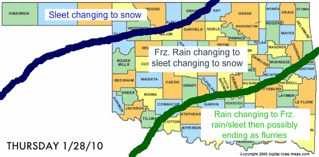
OKC nws forecast area
...WINTER STORM WATCH IN EFFECT FROM THURSDAY MORNING THROUGH
LATE THURSDAY NIGHT...
THE NATIONAL WEATHER SERVICE IN NORMAN HAS ISSUED A WINTER STORM
WATCH...WHICH IS IN EFFECT FROM THURSDAY MORNING THROUGH LATE
THURSDAY NIGHT.
* AFTER TWO WEEKS OF RELATIVELY MILD WEATHER... A WINTER STORM
WILL TAKE AIM ON THE SOUTHERN PLAINS AROUND THURSDAY. COLD AIR
CURRENTLY IN PLACE OVER CANADA WILL MOVE INTO THE AREA WEDNESDAY
BEHIND A STRONG COLD FRONT. AS THE COLD AIR DEEPENS OVER THE
AREA LATE WEDNESDAY INTO THURSDAY...A STORM SYSTEM WILL
APPROACH FROM THE WEST. A VARIETY OF WINTER WEATHER WILL BE THE
RESULT.
* TIMING: THE MOST LIKELY TIME FOR HAZARDOUS WINTER WEATHER WILL
BE FROM EARLY THURSDAY MORNING THROUGH EARLY FRIDAY MORNING.
* MAIN IMPACTS: FREEZING RAIN MAY BEGIN TO ACCUMULATE ON
POWER LINES AND ELEVATED SURFACES DURING THE DAY THURSDAY. THE
MOST LIKELY AREA FOR SIGNIFICANT ICE ACCUMULATIONS APPEARS TO BE
ACROSS SOUTHERN OKLAHOMA AND PARTS OF WESTERN NORTH TEXAS. SLEET AND
SNOW ACCUMULATIONS APPEAR MORE LIKELY ACROSS CENTRAL AND
NORTHERN OKLAHOMA ALTHOUGH SOME FREEZING RAIN WILL BE POSSIBLE.
* OTHER IMPACTS: GUSTY NORTH AND NORTHEAST WINDS AROUND 25 TO 35
MPH WILL ADD ADDITIONAL STRESS TO POWER LINES THAT HAVE ICE
ACCUMULATIONS. SOME BLOWING AN DRIFTING OF SNOW WILL ALSO BE
POSSIBLE.
* PRECAUTIONARY/PREPAREDNESS ACTIONS...
A WINTER STORM WATCH MEANS THERE IS A POTENTIAL FOR SIGNIFICANT
SNOW...SLEET...OR ICE ACCUMULATIONS THAT MAY IMPACT TRAVEL.
CONTINUE TO MONITOR THE LATEST FORECASTS.
0 likes
The above post and any post by Ntxw is NOT an official forecast and should not be used as such. It is just the opinion of the poster and may or may not be backed by sound meteorological data. It is NOT endorsed by any professional institution including Storm2k. For official information, please refer to NWS products.
Help support Storm2K!
Help support Storm2K!
-
Extremeweatherguy
- Category 5
- Posts: 11095
- Joined: Mon Oct 10, 2005 8:13 pm
- Location: Florida
The following post is NOT an official forecast and should not be used as such. It is just the opinion of the poster and may or may not be backed by sound meteorological data. It is NOT endorsed by any professional institution including storm2k.org. For official information, please refer to NWS products.
Here are my initial thoughts on how this will play out across Oklahoma...
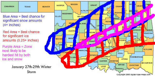
Keep in mind that being 3 days out the zones of highest impact could still shift significantly. It will all really depend on how quickly the 32F line moves southeast, how fast the column cools, and also the exact evolution of the precipitation shield. I will update my graphics accordingly over the next few days as these questionable points work themselves out.
0 likes

-
BlueIce
- S2K Supporter

- Posts: 194
- Age: 37
- Joined: Mon Sep 01, 2008 10:05 pm
- Location: Oklahoma City, Oklahoma
Re: Southern Plains winter wx thread (2009-2010)
msstateguy83 wrote:
Your forecast was pretty close last time MS State, care to throw another out there?
0 likes
-
msstateguy83
I have been looking over everything really well, I believe this is going to be another 'big one'
with a further southern track as the latest nam is showing that should speed up the front by
a good several hrs, I would not be shocked now to see frzing temps all the way south of
the ok/tx line by around 11 pm wed night.. I think we should see a rush of cold air funnel down,
things will start out as a frz rain,sleet mix with the chance of significant ice accums before
we even get started on the snow! could see ice accums somewhere between 0.25 - 0.50"
across the region with some areas slightly above 0.50"
then comes the snow by late in the afternoon on thursday basically iam expecting
a good 6 hours of VERY HEAVY SNOW... across central, west central, southcentral ok
with the heavyest being either side of i-44 by about 50-75 miles... I will not publish it
yet BUT depending on the upper level TEMPS lets just say if they are cold enough we
could be looking WELL, WELL PAST 10-12 INCHES in some isolated areas BUT iam not
even gonna start on that rightnow b/c there is some questions remaining as to how
cold, how quickly the upper levels will cool down so gonna hold the amounts for snow
across most of the area to between 4-8" with isolated amounts as i said either side
of 44 could reach 10"
i will post more later, have a snow total graphic up by tonight or first thing in the morning
The following post is NOT an official forecast and should not be used as such. It is just the opinion of the poster and may or may not be backed by sound meteorological data. It is NOT endorsed by any professional institution including storm2k.org. For official information, please refer to NWS products.
0 likes
-
Extremeweatherguy
- Category 5
- Posts: 11095
- Joined: Mon Oct 10, 2005 8:13 pm
- Location: Florida
The 00z NAM is impressive to say the least. It drops a good 3-4" of liquid equivalent precipitation across central Oklahoma Thursday into Friday, with 1.5-2.0" of that falling in the form of some kind of wintry precipitation type over Oklahoma City. Either way you slice it (freezing rain..sleet..or snow), IF the 00z NAM verifies, this would be a major storm.
0 likes
-
BlueIce
- S2K Supporter
- Posts: 194
- Age: 37
- Joined: Mon Sep 01, 2008 10:05 pm
- Location: Oklahoma City, Oklahoma
Re:
Extremeweatherguy wrote:The 00z NAM is impressive to say the least. It drops a good 3-4" of liquid equivalent precipitation across central Oklahoma Thursday into Friday, with 1.5-2.0" of that falling in the form of some kind of wintry precipitation type over Oklahoma City. Either way you slice it (freezing rain..sleet..or snow), IF the 00z NAM verifies, this would be a major storm.
sounds like you may have not missed your oppurtunity to see record snow in Oklahoma city. Is there an updated snow totals maps from the gfs. I don't have any good links for that.
0 likes
-
Extremeweatherguy
- Category 5
- Posts: 11095
- Joined: Mon Oct 10, 2005 8:13 pm
- Location: Florida
I just looked in-depth at the NAM skew-T predictions for the south side of Oklahoma City during this event, and these are the precipitation types it seems to be showing through the course of the storm...
6am Thurs - RAIN
9am Thurs - RAIN
12pm Thurs - RAIN/FRZ RAIN
3pm Thurs - FRZ RAIN
6pm Thurs - FRZ RAIN/SLEET
9pm Thurs - SLEET
12am Fri - SLEET/SNOW
3am Fri - SNOW
6am Fri - SNOW
This could become quite a dangerous situation if the NAM is correct! An ice storm followed by a possible blizzard could lead to major travel and power problems across the area Thursday afternoon into Friday!
0 likes
-
Extremeweatherguy
- Category 5
- Posts: 11095
- Joined: Mon Oct 10, 2005 8:13 pm
- Location: Florida
Re: Re:
The GFS is just now running, so no map for that quite yet. The NAM should have a new map up by about now, but I am not 100% sure where to get one like msstateguy83 posted earlier (which looked like this: http://wxcaster4.com/nam/CONUS1_MESO-ET ... A_84HR.gif). Hopefully he'll post one again later.BlueIce wrote:Extremeweatherguy wrote:The 00z NAM is impressive to say the least. It drops a good 3-4" of liquid equivalent precipitation across central Oklahoma Thursday into Friday, with 1.5-2.0" of that falling in the form of some kind of wintry precipitation type over Oklahoma City. Either way you slice it (freezing rain..sleet..or snow), IF the 00z NAM verifies, this would be a major storm.
sounds like you may have not missed your oppurtunity to see record snow in Oklahoma city. Is there an updated snow totals maps from the gfs. I don't have any good links for that.
Last edited by Extremeweatherguy on Mon Jan 25, 2010 11:09 pm, edited 2 times in total.
0 likes

-
Extremeweatherguy
- Category 5
- Posts: 11095
- Joined: Mon Oct 10, 2005 8:13 pm
- Location: Florida
Who is online
Users browsing this forum: No registered users and 73 guests