
SE TX/SW LA Winter WX - 2011-2012
Moderator: S2k Moderators
Forum rules
 The posts in this forum are NOT official forecast and should not be used as such. They are just the opinion of the poster and may or may not be backed by sound meteorological data. They are NOT endorsed by any professional institution or STORM2K.

The posts in this forum are NOT official forecast and should not be used as such. They are just the opinion of the poster and may or may not be backed by sound meteorological data. They are NOT endorsed by any professional institution or STORM2K.
-
PTrackerLA

- Category 5

- Posts: 5281
- Age: 42
- Joined: Thu Oct 10, 2002 8:40 pm
- Location: Lafayette, LA
Re: SE TX/SW LA winter wx: Finally, some sun!
18z GFS....now picking up on precipitation for next weekend for coastal areas with yet another Gulf low forming. Given the pattern we've been stuck in I would not be surprised. I'm sick of rain, but it can snow/sleet anytime!
0 likes
-
attallaman
Re: SE TX/SW LA winter wx: Finally, some sun!
Bring it on baby, bring it on, the snow that is. I too am tired of all the rain.PTrackerLA wrote:18z GFS....now picking up on precipitation for next weekend for coastal areas with yet another Gulf low forming. Given the pattern we've been stuck in I would not be surprised. I'm sick of rain, but it can snow/sleet anytime!
0 likes

Re: SE TX/SW LA winter wx: Finally, some sun!
attallaman wrote:Bring it on baby, bring it on, the snow that is. I too am tired of all the rain.PTrackerLA wrote:18z GFS....now picking up on precipitation for next weekend for coastal areas with yet another Gulf low forming. Given the pattern we've been stuck in I would not be surprised. I'm sick of rain, but it can snow/sleet anytime!
It will most probably be rain - that seems to be all that we get. The past two days of sunshine have been quite nice I must say!

0 likes
-
attallaman
Re: SE TX/SW LA winter wx: Finally, some sun!
It was very nice here yesterday, sunny skies, very little wind yet cool all of which was better than the weather I received here last week, much better.LaBreeze wrote:attallaman wrote:Bring it on baby, bring it on, the snow that is. I too am tired of all the rain.PTrackerLA wrote:18z GFS....now picking up on precipitation for next weekend for coastal areas with yet another Gulf low forming. Given the pattern we've been stuck in I would not be surprised. I'm sick of rain, but it can snow/sleet anytime!
It will most probably be rain - that seems to be all that we get. The past two days of sunshine have been quite nice I must say!
0 likes
-
srainhoutx

- S2K Supporter

- Posts: 6919
- Age: 68
- Joined: Sun Jan 14, 2007 11:34 am
- Location: Haywood County, NC
- Contact:
Re: SE TX/SW LA winter wx: Finally, some sun!
Looks like it could get rather bumpy around here on Wednesday. SPC has our area under a Slight Risk at this time...

DAY 3 CONVECTIVE OUTLOOK
NWS STORM PREDICTION CENTER NORMAN OK
0129 AM CST MON DEC 21 2009
VALID 231200Z - 241200Z
...THERE IS A SLGT RISK OF SVR TSTMS OVER EAST TX...ERN OK...LA...AR
AND FAR SRN MO...
...SRN PLAINS/OZARKS/LOWER MS VALLEY...
AN IMPRESSIVE UPPER-LEVEL SYSTEM WILL MOVE QUICKLY EWD ACROSS
ROCKIES WEDNESDAY. AHEAD OF THE SYSTEM...A WELL-DEVELOPED LOW-LEVEL
JET WILL RESULT IN STRONG MOISTURE ADVECTION ACROSS THE ERN PART OF
THE SRN PLAINS AND LOWER MS VALLEY. ELEVATED THUNDERSTORMS APPEAR
LIKELY TO BE ONGOING ALONG THE AXIS OF THE LOW-LEVEL JET WEDNESDAY
MORNING ACROSS LA AND AR. THIS SHOULD ENCOURAGE THE STRONGEST
DESTABILIZATION IN AREAS FARTHER WEST ACROSS EAST TX AND SE OK BY
MIDDAY. ALTHOUGH MODEL FORECASTS DIFFER ON HOW FAR WEST SFC-BASED
DEVELOPMENT WILL OCCUR...HAVE SIDED WITH THE GFS WHICH INITIATES
SFC-BASED THUNDERSTORMS FROM NEAR DALLAS/FORTH WORTH SWD TO THE
HOUSTON AREA WEDNESDAY AFTERNOON. THIS CONVECTION ORGANIZES INTO A
SQUALL-LINE WEDNESDAY NIGHT ALONG THE WRN SIDE OF A 50 TO 60 KT
LOW-LEVEL JET AS THE UPPER-LEVEL LOW MOVES INTO THE SRN PLAINS.
ETA-KF FORECAST SOUNDINGS SHOW WEAK INSTABILITY ACROSS THE WARM
SECTOR BUT A VERY STRONG DEEP LAYER SHEAR ENVIRONMENT SHOULD
OVERCOME THIS LIMITING FACTOR. 0-6 KM SHEAR VALUES IN THE 55 TO 70
KT RANGE SHOULD EASILY BE SUFFICIENT FOR SUPERCELLS WITH TORNADO
POTENTIAL ESPECIALLY WEDNESDAY AFTERNOON AND EVENING ACROSS EAST TX
AND WRN LA. THE WIND DAMAGE THREAT SHOULD INCREASE AS A SQUALL-LINE
ORGANIZES AND MOVES EWD INTO THE OZARKS AND LOWER MS VALLEY. THE
SEVERE THREAT SHOULD STAY TO THE WEST OF THE LOW-LEVEL JET WHICH
SHOULD KEEP ANY SEVERE THREAT MARGINAL EAST OF THE MS RIVER.
..BROYLES.. 12/21/2009
0 likes
Carla/Alicia/Jerry(In The Eye)/Michelle/Charley/Ivan/Dennis/Katrina/Rita/Wilma/Ike/Harvey
Member: National Weather Association
Wx Infinity Forums
http://wxinfinity.com/index.php
Facebook.com/WeatherInfinity
Twitter @WeatherInfinity
Member: National Weather Association
Wx Infinity Forums
http://wxinfinity.com/index.php
Facebook.com/WeatherInfinity
Twitter @WeatherInfinity
-
srainhoutx
- S2K Supporter
- Posts: 6919
- Age: 68
- Joined: Sun Jan 14, 2007 11:34 am
- Location: Haywood County, NC
- Contact:
Re: SE TX/SW LA winter wx: Finally, some sun!
Morning e-mail from Jeff...
Cold and dry air mass over the region will begin to modify today as surface high pressure cell overhead moves eastward. Already have southerly winds returning to the area and expect moisture levels to begin to increase this afternoon. Longwave trough will deepen over the Rockies over the next 48 hours with a strong upper level storm system developing over the 4 corners area and then track E to ENE across TX Wed/Thurs. This system will bring a late week blizzard across much of the Midwest and pour could polar air southward into the southern plains by Thursday.
Approaching upper level trough will activate a southerly low level jet this evening with low clouds quickly filling in after midnight. Will see low temperatures prior to midnight and then a slow warming as clouds thicken and warm air advection increases. Mostly cloudy Tuesday with a few showers possible. Surface dewpoints will likely begin to close in on the lower 60’s by late Tuesday and this will bring a bout of sea fog to the bays and coastal waters where water temperatures are in the upper 50’s.
Impressive storm system and jet stream dynamics come to bear across the region Wed as a strong upper level low moves across NW TX with surface low pressure developing over SC TX and track NE toward the ARKLATX region. SE TX will be warm sectored with mid 60 degree dewpoints pouring northward. Expect dense sea fog to lock in the bays from Tuesday evening-Wed evening as dewpoints exceed coastal water temps. 250mb winds become strongly divergent Wed afternoon with strong speed and directional shear across the area. Factors holding back a big severe outbreak appears to be quality of Gulf moisture return as previous fronts have done a number on the moisture pool over the Gulf. Feel the models may possibly be under-estimating the degree of moisture return and a higher severe threat may be warranted for the Wed PM time period. Will need to keep a close eye on this over the next 24-36 hours as low level helicity values would be supportive of supercells and tornadoes.
Next item of concern is how much cold air drops southward behind this system and how cold does it get by the end of the week. GFS has been trending warmer with this post frontal air mass and the general agreement now is that a Pacific front will cross the area Wed PM taking temperatures for Christmas Eve into the 50’s followed by the lagging polar air arriving late Christmas Even into early Christmas Day. GFS may be too warm with this air mass especially when considering the large snow event that will be ongoing north over the plains as far south as OK…so I still like the colder side of things although maybe not freezing on Christmas morning. GFS along with other guidance has at time been hinting that a short wave may drop down the backside of the trough the 26/27 with the cold air in place. 00Z runs of the GFS is back on the dry side this go around…but it has been flipping nearly 180 degrees with each run. Not sure there will be much moisture to work with although the formation of a NW Gulf surface trough is possible. For now will go with the drier side of guidance with maybe an increase in clouds Saturday. This period also bears close watch as stronger lift and moisture could result in the possibility of winter precipitation, but this is highly uncertain and a very low confidence forecast when compared to the Dec 4 event.
0 likes
Carla/Alicia/Jerry(In The Eye)/Michelle/Charley/Ivan/Dennis/Katrina/Rita/Wilma/Ike/Harvey
Member: National Weather Association
Wx Infinity Forums
http://wxinfinity.com/index.php
Facebook.com/WeatherInfinity
Twitter @WeatherInfinity
Member: National Weather Association
Wx Infinity Forums
http://wxinfinity.com/index.php
Facebook.com/WeatherInfinity
Twitter @WeatherInfinity
-
srainhoutx
- S2K Supporter
- Posts: 6919
- Age: 68
- Joined: Sun Jan 14, 2007 11:34 am
- Location: Haywood County, NC
- Contact:
Re: SE TX/SW LA winter wx: Finally, some sun!
Larry Cosgrove tonight in the Houston Examiner...
While folks bast East got slammed with a heavy snowstorm (the so-called "Blizzard of 2009" only reached that criteria in central/eastern Long Island NY), Houston and environs has settled into a fair, chilly weather groove during the weekend. But in the radically changing forecast landscape that is Texas, yet another shift is expected on Monday.
The cold center of high pressure is shifting eastward in advance of two important disturbances. One along the West Coast is supplying the energy and cold advection, and another impulse in the subtropical jet stream over southern Mexico is loaded with moisture. These two systems will merge into one giant, negative-tilt storm complex that will be associated with a variety of weather types. From E OK and E TX (including Houston) into the Tennessee and lower Ohio Valleys, severe thunderstorms and heavy rainfall will be the primary concerns. Further north and west, everything from a blizzard (W KS into IA and MN) to an ice storm (along a Topeka KS....Des Moines IA....Green Bay WI....Grand Rapids MI arc) could strike the central and eastern thirds of the nation around the Christmas holiday.
For Texas, the chance for strong thunderstorms on Christmas Eve will ultimately lead to a clearing and colder Christmas Day. Those of you hankering for a White Christmas will have to travel about 750 miles north to achieve your goal. But as a sort of "nod from nature" to those living in the Bayou City but having roots in the Midwest and Northeast, I hold out the slim hope that our infamous southern branch windfield could whip up another Saturday Night Special on December 26. The operational GFS, with some support from the American and European ensemble packages, creates a small storm on the trailing cold front over the Gulf of Mexico. If we are lucky, there is a small chance that some of the white stuff could trudge into the Texas Gulf Coast.
And, oh yeah, it will be cold this weekend....
The Forecast
Monday: Mostly sunny with a more cloudiness late day. Milder. Highs 66 Jersey Village to 70 Mims
Monday Night: Mostly cloudy, breezy and milder. Lows 52 Willis to 56 Galveston
Tuesday: Variable cloudiness, breezy, warmer and more humid. A few showers are likely. Highs 72 Liberty to 76 East Columbia
Tuesday Night: Mostly cloudy, breezy, mild and humid with a few showers. Lows 61 New Waverly to 65 Quintana
Wednesday: Mostly cloudy, windy, warm and humid with showers and thunderstorms. Highs 74 Fostoria to 78 Sugar Land
Holiday Weekend Outlook
Thursday, Christmas Eve: Showers early. Then clearing, breezy and colder. Morning High 68, Evening Low 38
Friday, Christmas Day: Mostly to partly sunny and colder. High 54, Low 36
Saturday: Mostly cloudy, colder with flurries possible. High 42, Low 31
Sunday: Sunny and chilly. High 48, Low 28
0 likes
Carla/Alicia/Jerry(In The Eye)/Michelle/Charley/Ivan/Dennis/Katrina/Rita/Wilma/Ike/Harvey
Member: National Weather Association
Wx Infinity Forums
http://wxinfinity.com/index.php
Facebook.com/WeatherInfinity
Twitter @WeatherInfinity
Member: National Weather Association
Wx Infinity Forums
http://wxinfinity.com/index.php
Facebook.com/WeatherInfinity
Twitter @WeatherInfinity
-
CYCLONE MIKE
- Category 5
- Posts: 2183
- Joined: Tue Aug 31, 2004 6:04 pm
- Location: Gonzales, LA
Re: SE TX/SW LA winter wx: Finally, some sun!
Here is SE LA's long range AFD. Can anyone shed some more light onto what they are seeing?
LONG TERM...
ANOTHER STRONG SYSTEM IS LOOKING TO DEVELOP AND MOVE INTO THE
PICTURE AROUND TUE OR WED OF NEXT WEEK. THIS FALLS WELL OUTSIDE OF
OUR FCAST PACK BUT THIS SYSTEM ALSO LOOKS INTERESTING AS THE SFC
LOW MAY MOVE VERY CLOSE TO THE AREA.
BTW no mention of coldest temps of season, hard freezes, or chance of winter precip this weekend as was the topic earlier this week. What has changed?
0 likes
-
srainhoutx
- S2K Supporter
- Posts: 6919
- Age: 68
- Joined: Sun Jan 14, 2007 11:34 am
- Location: Haywood County, NC
- Contact:
Re: SE TX/SW LA winter wx: Finally, some sun!
Noon hour e-mail from Jeff...
Air mass continues to modify this morning under strong southerly winds.
Warm air advection regime in full swing with south winds of 15-25mph and greater across the region brining upper 50 to low 60 degree dewpoints northward. GPS sounder and morning radio soundings indicate the air mass over the Gulf of Mexico is modified continental air with the rich tropical air mass confined to the Caribbean Sea. Upper level trough will deepen and move into the central US Wed with continued flow of warm and increasing moist air northward. Scattered showers this afternoon will build into more numerous showers and thunderstorms tonight and Wednesday as the air mass becomes increasingly unstable. Capping inversion will spread ENE from the higher terrain of NE Mexico Wed with deeper surface based convection limited to areas mainly along and E of I-45. SPC has most of the area within the Day 2 slight risk…but feel the severe threat is fairly marginal at this time.
Upper level storm system really cranks up Wed PM into Thurs with a large winter storm/blizzard developing over the central US. Cold polar air mass will drop southward down the backside of this feature and into Texas late Christmas Eve. Will trend colder than guidance and show lows near freezing Christmas morning and highs only in the 40’s during the day. Models remain unsettled into the weekend with the CMC showing precip. developing within the cold air mass while the GFS and ECMWF are dry. Will go ahead and trend toward the colder solutions…as feel the GFS is too warm anyhow. For now will increase clouds, but not any rain chances Sat-Sun. If the GFS starts to show a deeper S/W and coastal trough and sling the moisture northward precipitation chances may be needed this weekend and some of what falls could be freezing/frozen…but for now will keep it dry.
Stormy and cold pattern looks to continue for the last week of the decade!
0 likes
Carla/Alicia/Jerry(In The Eye)/Michelle/Charley/Ivan/Dennis/Katrina/Rita/Wilma/Ike/Harvey
Member: National Weather Association
Wx Infinity Forums
http://wxinfinity.com/index.php
Facebook.com/WeatherInfinity
Twitter @WeatherInfinity
Member: National Weather Association
Wx Infinity Forums
http://wxinfinity.com/index.php
Facebook.com/WeatherInfinity
Twitter @WeatherInfinity
-
srainhoutx
- S2K Supporter
- Posts: 6919
- Age: 68
- Joined: Sun Jan 14, 2007 11:34 am
- Location: Haywood County, NC
- Contact:
Re: SE TX/SW LA winter wx: Finally, some sun!
Absolutely pouring rain in NW Harris County...
DAY 1 CONVECTIVE OUTLOOK
NWS STORM PREDICTION CENTER NORMAN OK
0155 PM CST TUE DEC 22 2009
VALID 222000Z - 231200Z
...NO SVR TSTM AREAS FORECAST...
...ERN OK/WRN AR INTO CNTRL/ERN TX...
TRENDS IN REGIONAL VWP/PROFILER DATA INDICATE A GRADUAL BACKING AND
INTENSIFICATION OF LLJ ACROSS CNTRL AND ERN PARTS OF TX...LIKELY IN
RESPONSE TO APPROACH OF LEAD VORTICITY MAXIMUM TOWARD THE SRN
ROCKIES. THIS LOW-LEVEL MASS ADJUSTMENT IS SERVING TO ENHANCE THE
NWD/NEWD FLUX OF A MODIFIED CONTINENTAL AIR MASS THROUGH LOWER
ELEVATIONS OF THE SRN PLAINS WITH LOWER/MID 50S DEWPOINTS AS FAR N
AS THE RED RIVER AS OF 19Z.
RADAR/SATELLITE IMAGERY ARE SHOWING A GRADUAL DEEPENING OF CUMULUS
CONVECTION WITHIN MOISTENING AIR MASS W OF HOU WHERE RUC OBJECTIVE
FIELDS SUGGEST THAT ENVIRONMENT HAS BECOME WEAKLY UNSTABLE WITH
SBCAPE OF AROUND 500 J/KG. GIVEN THE PERSISTENT LOW-LEVEL WAA
FORECAST AND STRENGTHENING DEEP LAYER WIND FIELD...THERE IS SOME
QUESTION AS TO WHETHER ANY SEVERE THREAT WILL DEVELOP THROUGH THE
REMAINDER OF THE DIURNAL HEATING CYCLE. LATEST SHORT TERM MODEL
GUIDANCE SUGGESTS THAT CAPPING ASSOCIATED WITH AN EML /REF 12Z DRT
SOUNDING/ WILL SPREAD EWD TODAY IN ASSOCIATION WITH STRENGTHENING
WLY/SWLY FLOW ABOVE THE BOUNDARY LAYER. THIS MAY TEND TO LIMIT THE
VERTICAL GROWTH OF ABOVE-MENTIONED MOIST CONVECTION AND THE
POTENTIAL FOR STRONGER/MORE PERSISTENT UPDRAFTS. AS SUCH...ONLY LOW
SEVERE PROBABILITIES WILL BE MAINTAINED.
OTHERWISE...CURRENT SCENARIO ESTABLISHED IN PRIOR OUTLOOKS FOR
TONIGHT APPEARS ON TRACK WITH ONLY SMALL CHANGES MADE TO THE AREAL
LOCATION OF PROBABILITY AND GENERAL THUNDER LINES.
..MEAD.. 12/22/2009
0 likes
Carla/Alicia/Jerry(In The Eye)/Michelle/Charley/Ivan/Dennis/Katrina/Rita/Wilma/Ike/Harvey
Member: National Weather Association
Wx Infinity Forums
http://wxinfinity.com/index.php
Facebook.com/WeatherInfinity
Twitter @WeatherInfinity
Member: National Weather Association
Wx Infinity Forums
http://wxinfinity.com/index.php
Facebook.com/WeatherInfinity
Twitter @WeatherInfinity
-
attallaman
Re: SE TX/SW LA winter wx: Finally, some sun!
Is it forecasted to be cold here along the MS Gulf Coast for Christmas or just mild with lots of rain? I was looking for the thread labeled "Let it snow, let it snow, let it snow" but couldn't find it so I decided to post my question here.
0 likes
-
Nederlander
- S2K Supporter
- Posts: 1259
- Joined: Sat Jul 19, 2008 4:28 pm
- Location: Conroe, TX
Re: SE TX/SW LA winter wx: Finally, some sun!
It feels like its March outside. Muggy, Humid, 70 deg. 
0 likes
-
CajunMama
- Retired Staff

- Posts: 10791
- Joined: Thu Feb 06, 2003 9:57 pm
- Location: 30.22N, 92.05W Lafayette, LA
Re: SE TX/SW LA winter wx: Finally, some sun!
attallaman wrote:Is it forecasted to be cold here along the MS Gulf Coast for Christmas or just mild with lots of rain? I was looking for the thread labeled "Let it snow, let it snow, let it snow" but couldn't find it so I decided to post my question here.
I believe this is the thread you were looking for. The mods and the op can change the thread title. Just always look for the SE TX/SW LA winter wx part of the title. That never changes.
0 likes
-
attallaman
Re: SE TX/SW LA winter wx: Finally, some sun!
Thanks for letting me know and now does anyone have any opinions on whether or not it might be cold here in Biloxi, Mississippi on Christmas day? It's overcast here today with temperatures in the 60's.CajunMama wrote:attallaman wrote:Is it forecasted to be cold here along the MS Gulf Coast for Christmas or just mild with lots of rain? I was looking for the thread labeled "Let it snow, let it snow, let it snow" but couldn't find it so I decided to post my question here.
I believe this is the thread you were looking for. The mods and the op can change the thread title. Just always look for the SE TX/SW LA winter wx part of the title. That never changes.
OT: Can anyone recommend a free weather service I can download which will have an icon in my system tray, one which will display the temperature or blink to let me know of a severe weather alert? I used Weather Bug for years but my anti-virus and anti-spyware software recently kept picking up viruses and a trojan was detected a few weeks ago in Weather Bug so I finally went ahead and removed Weather Bug from my computer.
0 likes
-
srainhoutx
- S2K Supporter
- Posts: 6919
- Age: 68
- Joined: Sun Jan 14, 2007 11:34 am
- Location: Haywood County, NC
- Contact:
Re: SE TX/SW LA winter wx: Tornado Watch
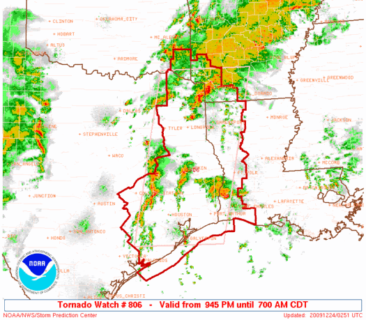
URGENT - IMMEDIATE BROADCAST REQUESTED
TORNADO WATCH NUMBER 806
NWS STORM PREDICTION CENTER NORMAN OK
945 PM CDT WED DEC 23 2009
THE NWS STORM PREDICTION CENTER HAS ISSUED A
TORNADO WATCH FOR PORTIONS OF
SOUTHWEST ARKANSAS
WESTERN LOUISIANA
FAR SOUTHEAST OKLAHOMA
EASTERN AND SOUTHEAST TEXAS
COASTAL WATERS
EFFECTIVE THIS WEDNESDAY NIGHT AND THURSDAY MORNING FROM 945 PM
UNTIL 700 AM CDT.
TORNADOES...HAIL TO 1.5 INCHES IN DIAMETER...THUNDERSTORM WIND
GUSTS TO 70 MPH...AND DANGEROUS LIGHTNING ARE POSSIBLE IN THESE
AREAS.
THE TORNADO WATCH AREA IS APPROXIMATELY ALONG AND 85 STATUTE
MILES EAST AND WEST OF A LINE FROM 35 MILES NORTH OF TEXARKANA
ARKANSAS TO 25 MILES EAST OF ANGLETON TEXAS. FOR A COMPLETE
DEPICTION OF THE WATCH SEE THE ASSOCIATED WATCH OUTLINE UPDATE
(WOUS64 KWNS WOU6).
REMEMBER...A TORNADO WATCH MEANS CONDITIONS ARE FAVORABLE FOR
TORNADOES AND SEVERE THUNDERSTORMS IN AND CLOSE TO THE WATCH
AREA. PERSONS IN THESE AREAS SHOULD BE ON THE LOOKOUT FOR
THREATENING WEATHER CONDITIONS AND LISTEN FOR LATER STATEMENTS
AND POSSIBLE WARNINGS.
OTHER WATCH INFORMATION...THIS TORNADO WATCH REPLACES TORNADO
WATCH NUMBER 805. WATCH NUMBER 805 WILL NOT BE IN EFFECT AFTER
945 PM CDT.
DISCUSSION...UPPER LOW WILL CONTINUE TO PUSH EWD INTO CENTRAL TX
OVERNIGHT WITH ASSOCIATED INCREASE IN SSELY LLJ FORECAST TO OCCUR
OVER ERN TX/WRN LA. BROKEN BANDS OF STORMS WILL LIKELY CONTINUE
DEVELOPING WITHIN BROAD LOW LEVEL CONFLUENCE ACROSS THIS AREA WHERE
VERY STRONG SHEAR WILL REMAIN SUPPORTIVE OF LOW-TOPPED SUPERCELLS
AND POSSIBLE TORNADOES. ACTIVITY MAY CONSOLIDATE INTO A LARGER
SQUALL LINE LATER TONIGHT/EARLY THURSDAY MORNING ALONG AND AHEAD OF
MAIN UPPER SYSTEM...MAINTAINING A RISK OF SEVERE THUNDERSTORMS
THROUGH DAYBREAK OVER PARTS OF WW.
AVIATION...TORNADOES AND A FEW SEVERE THUNDERSTORMS WITH HAIL
SURFACE AND ALOFT TO 1.5 INCHES. EXTREME TURBULENCE AND SURFACE
WIND GUSTS TO 60 KNOTS. A FEW CUMULONIMBI WITH MAXIMUM TOPS TO
400. MEAN STORM MOTION VECTOR 24035.
...EVANS
Hazard Tornadoes EF2+ Tornadoes
Likelihood Moderate Moderate
Severe Wind 65 kt+ Wind
Moderate Moderate
Severe Hail 2"+ Hail
Low Very Low
Note: See the experimental Public Watch (SEL) product with explicit hazard information section below. The expiration time in the watch graphic is amended if the watch is replaced, cancelled or extended.
Note: Click for Watch Status Reports.
SEL6
URGENT - IMMEDIATE BROADCAST REQUESTED
TORNADO WATCH NUMBER 806
NWS STORM PREDICTION CENTER NORMAN OK
945 PM CDT WED DEC 23 2009
THE NWS STORM PREDICTION CENTER HAS ISSUED A
TORNADO WATCH FOR PORTIONS OF
SOUTHWEST ARKANSAS
WESTERN LOUISIANA
FAR SOUTHEAST OKLAHOMA
EASTERN AND SOUTHEAST TEXAS
COASTAL WATERS
EFFECTIVE THIS WEDNESDAY NIGHT AND THURSDAY MORNING FROM 945 PM
UNTIL 700 AM CDT.
SEVERAL TORNADOES
ISOLATED INTENSE TORNADOES POSSIBLE
WIDELY SCATTERED DAMAGING WINDS
ISOLATED WIND GUSTS TO 70 MPH POSSIBLE
WIDELY SCATTERED LARGE HAIL TO 1.5 INCHES IN DIAMETER
THE TORNADO WATCH AREA IS APPROXIMATELY ALONG AND 85 STATUTE
MILES EAST AND WEST OF A LINE FROM 35 MILES NORTH OF TEXARKANA
ARKANSAS TO 25 MILES EAST OF ANGLETON TEXAS. FOR A COMPLETE
DEPICTION OF THE WATCH SEE THE ASSOCIATED WATCH OUTLINE UPDATE
(WOUS64 KWNS WOU6).
REMEMBER...A TORNADO WATCH MEANS CONDITIONS ARE FAVORABLE FOR
TORNADOES AND SEVERE THUNDERSTORMS IN AND CLOSE TO THE WATCH
AREA. PERSONS IN THESE AREAS SHOULD BE ON THE LOOKOUT FOR
THREATENING WEATHER CONDITIONS AND LISTEN FOR LATER STATEMENTS
AND POSSIBLE WARNINGS.
OTHER WATCH INFORMATION...THIS TORNADO WATCH REPLACES TORNADO
WATCH NUMBER 805. WATCH NUMBER 805 WILL NOT BE IN EFFECT AFTER
945 PM CDT.
DISCUSSION...UPPER LOW WILL CONTINUE TO PUSH EWD INTO CENTRAL TX
OVERNIGHT WITH ASSOCIATED INCREASE IN SSELY LLJ FORECAST TO OCCUR
OVER ERN TX/WRN LA. BROKEN BANDS OF STORMS WILL LIKELY CONTINUE
DEVELOPING WITHIN BROAD LOW LEVEL CONFLUENCE ACROSS THIS AREA WHERE
VERY STRONG SHEAR WILL REMAIN SUPPORTIVE OF LOW-TOPPED SUPERCELLS
AND POSSIBLE TORNADOES. ACTIVITY MAY CONSOLIDATE INTO A LARGER
SQUALL LINE LATER TONIGHT/EARLY THURSDAY MORNING ALONG AND AHEAD OF
MAIN UPPER SYSTEM...MAINTAINING A RISK OF SEVERE THUNDERSTORMS
THROUGH DAYBREAK OVER PARTS OF WW.
AVIATION...TORNADOES AND A FEW SEVERE THUNDERSTORMS WITH HAIL
SURFACE AND ALOFT TO 1.5 INCHES. EXTREME TURBULENCE AND SURFACE
WIND GUSTS TO 60 KNOTS. A FEW CUMULONIMBI WITH MAXIMUM TOPS TO
400. MEAN STORM MOTION VECTOR 24035.
...EVANS
Hazard Tornadoes EF2+ Tornadoes
Likelihood Moderate Moderate
Severe Wind 65 kt+ Wind
Moderate Moderate
Severe Hail 2"+ Hail
Low Very Low
SEL6
URGENT - IMMEDIATE BROADCAST REQUESTED
TORNADO WATCH NUMBER 806
NWS STORM PREDICTION CENTER NORMAN OK
945 PM CDT WED DEC 23 2009
THE NWS STORM PREDICTION CENTER HAS ISSUED A
TORNADO WATCH FOR PORTIONS OF
SOUTHWEST ARKANSAS
WESTERN LOUISIANA
FAR SOUTHEAST OKLAHOMA
EASTERN AND SOUTHEAST TEXAS
COASTAL WATERS
EFFECTIVE THIS WEDNESDAY NIGHT AND THURSDAY MORNING FROM 945 PM
UNTIL 700 AM CDT.
TORNADOES...HAIL TO 1.5 INCHES IN DIAMETER...THUNDERSTORM WIND
GUSTS TO 70 MPH...AND DANGEROUS LIGHTNING ARE POSSIBLE IN THESE
AREAS.
THE TORNADO WATCH AREA IS APPROXIMATELY ALONG AND 85 STATUTE
MILES EAST AND WEST OF A LINE FROM 35 MILES NORTH OF TEXARKANA
ARKANSAS TO 25 MILES EAST OF ANGLETON TEXAS. FOR A COMPLETE
DEPICTION OF THE WATCH SEE THE ASSOCIATED WATCH OUTLINE UPDATE
(WOUS64 KWNS WOU6).
REMEMBER...A TORNADO WATCH MEANS CONDITIONS ARE FAVORABLE FOR
TORNADOES AND SEVERE THUNDERSTORMS IN AND CLOSE TO THE WATCH
AREA. PERSONS IN THESE AREAS SHOULD BE ON THE LOOKOUT FOR
THREATENING WEATHER CONDITIONS AND LISTEN FOR LATER STATEMENTS
AND POSSIBLE WARNINGS.
OTHER WATCH INFORMATION...THIS TORNADO WATCH REPLACES TORNADO
WATCH NUMBER 805. WATCH NUMBER 805 WILL NOT BE IN EFFECT AFTER
945 PM CDT.
DISCUSSION...UPPER LOW WILL CONTINUE TO PUSH EWD INTO CENTRAL TX
OVERNIGHT WITH ASSOCIATED INCREASE IN SSELY LLJ FORECAST TO OCCUR
OVER ERN TX/WRN LA. BROKEN BANDS OF STORMS WILL LIKELY CONTINUE
DEVELOPING WITHIN BROAD LOW LEVEL CONFLUENCE ACROSS THIS AREA WHERE
VERY STRONG SHEAR WILL REMAIN SUPPORTIVE OF LOW-TOPPED SUPERCELLS
AND POSSIBLE TORNADOES. ACTIVITY MAY CONSOLIDATE INTO A LARGER
SQUALL LINE LATER TONIGHT/EARLY THURSDAY MORNING ALONG AND AHEAD OF
MAIN UPPER SYSTEM...MAINTAINING A RISK OF SEVERE THUNDERSTORMS
THROUGH DAYBREAK OVER PARTS OF WW.
AVIATION...TORNADOES AND A FEW SEVERE THUNDERSTORMS WITH HAIL
SURFACE AND ALOFT TO 1.5 INCHES. EXTREME TURBULENCE AND SURFACE
WIND GUSTS TO 60 KNOTS. A FEW CUMULONIMBI WITH MAXIMUM TOPS TO
400. MEAN STORM MOTION VECTOR 24035.
...EVANS
Hazard Tornadoes EF2+ Tornadoes
Likelihood Moderate Moderate
Severe Wind 65 kt+ Wind
Moderate Moderate
Severe Hail 2"+ Hail
Low Very Low
Note: Click for Watch Status Reports.
WOUS64 KWNS 240243
WOU6
BULLETIN - IMMEDIATE BROADCAST REQUESTED
TORNADO WATCH OUTLINE UPDATE FOR WT 806
NWS STORM PREDICTION CENTER NORMAN OK
945 PM CDT WED DEC 23 2009
TORNADO WATCH 806 IS IN EFFECT UNTIL 700 AM CDT FOR THE
FOLLOWING LOCATIONS
ARC027-057-061-073-081-091-133-241200-
/O.NEW.KWNS.TO.A.0806.091224T0245Z-091224T1200Z/
AR
. ARKANSAS COUNTIES INCLUDED ARE
COLUMBIA HEMPSTEAD HOWARD
LAFAYETTE LITTLE RIVER MILLER
SEVIER
LAC011-013-015-017-019-023-027-031-069-081-085-115-119-241200-
/O.NEW.KWNS.TO.A.0806.091224T0245Z-091224T1200Z/
LA
. LOUISIANA PARISHES INCLUDED ARE
BEAUREGARD BIENVILLE BOSSIER
CADDO CALCASIEU CAMERON
CLAIBORNE DE SOTO NATCHITOCHES
RED RIVER SABINE VERNON
WEBSTER
OKC089-241200-
/O.NEW.KWNS.TO.A.0806.091224T0245Z-091224T1200Z/
OK
. OKLAHOMA COUNTIES INCLUDED ARE
MCCURTAIN
TXC005-015-037-039-041-051-063-067-071-073-089-157-159-167-183-
185-199-201-203-225-241-245-291-313-315-321-339-343-347-351-361-
365-373-387-401-403-405-407-419-423-449-455-457-459-471-473-477-
481-499-241200-
/O.NEW.KWNS.TO.A.0806.091224T0245Z-091224T1200Z/
TX
. TEXAS COUNTIES INCLUDED ARE
ANGELINA AUSTIN BOWIE
BRAZORIA BRAZOS BURLESON
CAMP CASS CHAMBERS
CHEROKEE COLORADO FORT BEND
FRANKLIN GALVESTON GREGG
GRIMES HARDIN HARRIS
HARRISON HOUSTON JASPER
JEFFERSON LIBERTY MADISON
MARION MATAGORDA MONTGOMERY
MORRIS NACOGDOCHES NEWTON
ORANGE PANOLA POLK
RED RIVER RUSK SABINE
SAN AUGUSTINE SAN JACINTO SHELBY
SMITH TITUS TRINITY
TYLER UPSHUR WALKER
WALLER WASHINGTON WHARTON
WOOD
GMZ335-350-355-430-432-450-241200-
/O.NEW.KWNS.TO.A.0806.091224T0245Z-091224T1200Z/
CW
. ADJACENT COASTAL WATERS INCLUDED ARE
GALVESTON BAY
COASTAL WATERS FROM FREEPORT TO MATAGORDA SHIP CHANNEL TX OUT 20
NM
COASTAL WATERS FROM HIGH ISLAND TO FREEPORT TX OUT 20 NM
SABINE LAKE
CALCASIEU LAKE
COASTAL WATERS FROM CAMERON LA TO HIGH ISLAND TX OUT 20 NM
ATTN...WFO...SHV...LCH...HGX...
Hazard Tornadoes EF2+ Tornadoes
Likelihood Moderate Moderate
Severe Wind 65 kt+ Wind
Moderate Moderate
Severe Hail 2"+ Hail
Low Very Low
Note: The Aviation Watch (SAW) product is an approximation to the watch area. The actual watch is depicted by the shaded areas.
SAW6
WW 806 TORNADO AR LA OK TX CW 240245Z - 241200Z
AXIS..85 STATUTE MILES EAST AND WEST OF LINE..
35N TXK/TEXARKANA AR/ - 25E LBX/ANGLETON TX/
..AVIATION COORDS.. 75NM E/W /27N TXK - 53SSE IAH/
HAIL SURFACE AND ALOFT..1.5 INCHES. WIND GUSTS..60 KNOTS.
MAX TOPS TO 400. MEAN STORM MOTION VECTOR 24035.
REPLACES WW 805..AR LA OK TX
LAT...LON 33959251 29119365 29119645 33959548
THIS IS AN APPROXIMATION TO THE WATCH AREA. FOR A
COMPLETE DEPICTION OF THE WATCH SEE WOUS64 KWNS
FOR WOU6.
Watch 806 Status Report Message has not been issued yet.
0 likes
Carla/Alicia/Jerry(In The Eye)/Michelle/Charley/Ivan/Dennis/Katrina/Rita/Wilma/Ike/Harvey
Member: National Weather Association
Wx Infinity Forums
http://wxinfinity.com/index.php
Facebook.com/WeatherInfinity
Twitter @WeatherInfinity
Member: National Weather Association
Wx Infinity Forums
http://wxinfinity.com/index.php
Facebook.com/WeatherInfinity
Twitter @WeatherInfinity
-
southerngale

- Retired Staff
- Posts: 27418
- Joined: Thu Oct 10, 2002 1:27 am
- Location: Southeast Texas (Beaumont area)
Re: SE TX/SW LA winter wx: Tornado Watch
Winter weather... tornado watch!
Tornado Watch
TORNADO WATCH OUTLINE UPDATE FOR WT 806
NWS STORM PREDICTION CENTER NORMAN OK
945 PM CDT WED DEC 23 2009
TORNADO WATCH 806 IS IN EFFECT UNTIL 700 AM CDT FOR THE
FOLLOWING LOCATIONS
TXC005-015-037-039-041-051-063-067-071-073-089-157-159-167-183-
185-199-201-203-225-241-245-291-313-315-321-339-343-347-351-361-
365-373-387-401-403-405-407-419-423-449-455-457-459-471-473-477-
481-499-241200-
/O.NEW.KWNS.TO.A.0806.091224T0245Z-091224T1200Z/
TX
. TEXAS COUNTIES INCLUDED ARE
ANGELINA AUSTIN BOWIE
BRAZORIA BRAZOS BURLESON
CAMP CASS CHAMBERS
CHEROKEE COLORADO FORT BEND
FRANKLIN GALVESTON GREGG
GRIMES HARDIN HARRIS
HARRISON HOUSTON JASPER
JEFFERSON LIBERTY MADISON
MARION MATAGORDA MONTGOMERY
MORRIS NACOGDOCHES NEWTON
ORANGE PANOLA POLK
RED RIVER RUSK SABINE
SAN AUGUSTINE SAN JACINTO SHELBY
SMITH TITUS TRINITY
TYLER UPSHUR WALKER
WALLER WASHINGTON WHARTON
WOOD
$$
DAY 1 CONVECTIVE OUTLOOK
NWS STORM PREDICTION CENTER NORMAN OK
0645 PM CST WED DEC 23 2009
VALID 240100Z - 241200Z
...THERE IS A SLGT RISK OF SVR TSTMS FROM ERN TX/LA...NWD INTO ERN
OK/WRN AR...
...CNTRL/ERN TX...SERN OK...WRN AR/LA...
INCREASINGLY DEFINED UPPER LOW IS DIGGING ESEWD AT ROUGHLY 20KT
ACROSS NM TOWARD THE TX SOUTH PLAINS. LEADING EDGE OF SHARP MID
LEVEL ASCENT/WARM CONVEYOR IS APPROACHING THE WRN EDGE OF MOIST
BOUNDARY LAYER WHICH SHOULD CONTRIBUTE GREATLY TO AN EXPANSION IN
THUNDERSTORM ACTIVITY OVER THE NEXT FEW HOURS...ESPECIALLY ALONG THE
I-35 CORRIDOR. 00Z SOUNDING FROM FWD IS NOT PARTICULARLY UNSTABLE
WITH ROUGHLY 500 J/KG MUCAPE...HOWEVER LAPSE RATES ARE FAIRLY STEEP.
FARTHER EAST...SOUNDINGS FROM SHV AND LZK SUGGEST LOW LEVEL WARM
ADVECTION IS DRIVING THE MAJORITY OF CONVECTION ON THE COOL SIDE OF
THE WARM FRONT ACROSS THE ARKLATEX. WITHIN THIS ACTIVITY SEVERAL
EMBEDDED SUPERCELLS PERSIST. AS THE UPPER TROUGH APPROACHES IT
APPEARS ADDITIONAL WARM SECTOR CONVECTION...OR NEAR-SFC BASED
THUNDERSTORMS SHOULD EVOLVE. GIVEN THE STRONG VERTICAL SHEAR IT
WOULD SEEM THAT ISOLATED SUPERCELLS CAN BE EXPECTED...THOUGH STRONG
FORCING MAY ULTIMATELY RESULT IN A STRONGLY FORCED LINE OF
CONVECTION AS IT PROGRESSES ACROSS THE SLIGHT RISK. DAMAGING WINDS
MAY BECOME THE PRIMARY SEVERE THREAT AS THE SQUALL LINE MATURES.
0 likes
Please support Storm2k by making a donation today. It is greatly appreciated! Click here: 
 my Cowboys my Rockets my Astros
my Cowboys my Rockets my Astros-
srainhoutx
- S2K Supporter
- Posts: 6919
- Age: 68
- Joined: Sun Jan 14, 2007 11:34 am
- Location: Haywood County, NC
- Contact:
Re: SE TX/SW LA winter wx: Tornado Watch
NATIONAL WEATHER SERVICE HOUSTON/GALVESTON TX
1011 PM CST WED DEC 23 2009
.UPDATE...
NEW TORNADO WATCH IN EFFECT FOR ALL OF SOUTHEAST TEXAS BUT JACKSON
COUNTY.
&&
.DISCUSSION...
LL JET RIPPING THROUGH THE AREA AND VWP INDICATED A STRONGLY
SHEARED ENVIRONMENT IN PLACE. INSTABILITY HAS BEEN LACKING TO SOME
DEGREE AS INVERSION (PER CRP/ACARS SOUNDINGS) INDICATING ONLY A
THIN SLICE OF CAPE TO WORK WITH SO FAR. EVEN SO A FEW STORMS HAVE
BEEN PUTTING DOWN 1 TO 2 INCH PER HOUR RAINFALL RATES. RADAR
ESTIMATES OF 3 INCHES IN GRIMES/WALLER COUNTY.
RECENT STORMS ALSO EXHIBITING SOME ROTATION THOUGH SO FAR IT HAS
BEEN WEAK TO MODERATE. WILL BE KEEPING A CLOSE EYE ON STORMS
TRACKING THROUGH THE AREA. HELICITY VALUES OF 170-250 PREVAILING
OVER THE EASTERN 2/3RDS OF THE AREA.
NEXT WILL BE THE COLD FRONT TO SWEEP IN AFTER MIDNIGHT AND SHOULD
BE EXITING THE AREA 6-8 AM. HODOGRAPH MAY BECOME MORE LINEAR AND
WOULD EXPECT A LINE TO COME IN FROM THE SW AND AND FROM THE NW
MEETING UP OVER THE CENTRAL CWA FILLING IN OVER THE EASTERN HALF
OF THE AREA. SOME WIND DAMAGE POTENTIAL WITH LINEAR MCS/EMBEDDED
BOWING STRUCTURES.
HAVE ISSUED A WIND ADVISORY FOR THE CWA FOR 6A-6P THURSDAY AS
IMPRESSIVE WINDS ALOFT IN 925-850 LAYER SHOULD MIX DOWN DURING THE
DAY AND EXPECT SUSTAINED WINDS OF 20-25 KNOTS WITH GUSTS NEAR 35
KNOTS AT TIMES.
0 likes
Carla/Alicia/Jerry(In The Eye)/Michelle/Charley/Ivan/Dennis/Katrina/Rita/Wilma/Ike/Harvey
Member: National Weather Association
Wx Infinity Forums
http://wxinfinity.com/index.php
Facebook.com/WeatherInfinity
Twitter @WeatherInfinity
Member: National Weather Association
Wx Infinity Forums
http://wxinfinity.com/index.php
Facebook.com/WeatherInfinity
Twitter @WeatherInfinity


-
srainhoutx
- S2K Supporter
- Posts: 6919
- Age: 68
- Joined: Sun Jan 14, 2007 11:34 am
- Location: Haywood County, NC
- Contact:
Re: SE TX/SW LA winter wx: Tornado Watch
Yeah Jasosn, pressure are dropping faily quick at IAH. Going to be a long night. STW are starting out W in San Antonio along the front and squall line forming.
0 likes
Carla/Alicia/Jerry(In The Eye)/Michelle/Charley/Ivan/Dennis/Katrina/Rita/Wilma/Ike/Harvey
Member: National Weather Association
Wx Infinity Forums
http://wxinfinity.com/index.php
Facebook.com/WeatherInfinity
Twitter @WeatherInfinity
Member: National Weather Association
Wx Infinity Forums
http://wxinfinity.com/index.php
Facebook.com/WeatherInfinity
Twitter @WeatherInfinity
-
Yankeegirl

- Category 5
- Posts: 3417
- Age: 50
- Joined: Sun May 23, 2004 11:59 pm
- Location: Cy-Fair, Northwest Houston
- Contact:
Re: SE TX/SW LA winter wx: Tornado Watch
Getting Nailed here near Katy.... Lots of rain and wind!! Not much on the severe side, I havent heard a single crack of thunder... But the wind is strong!!! Makes are all lose things are picked up.... Good gusts with this cell....
0 likes
Who is online
Users browsing this forum: No registered users and 124 guests