
African mammoth bomb....
Moderator: S2k Moderators
Forum rules

The posts in this forum are NOT official forecasts and should not be used as such. They are just the opinion of the poster and may or may not be backed by sound meteorological data. They are NOT endorsed by any professional institution or STORM2K. For official information, please refer to products from the National Hurricane Center and National Weather Service.
African mammoth bomb....
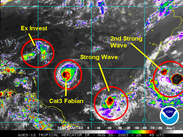
On the image below, you can see it still over Africa. Of course it's way too early to tell but I thought I'd point it out. Looks like a biggun'.
0 likes
-
Stormsfury

- Category 5

- Posts: 10549
- Age: 53
- Joined: Wed Feb 05, 2003 6:27 pm
- Location: Summerville, SC
This is the wave that was a huge convective complex with banding features over Central Africa about 2-3 days ago. This is also the same wave I believe has a real chance of becoming something more than a "wave". The first wave that exited the coast is drawing moisture northward behind the swirl, which I think will be what the second wave will need.
SF
SF
0 likes
-
cycloneye

- Admin

- Posts: 149751
- Age: 69
- Joined: Thu Oct 10, 2002 10:54 am
- Location: San Juan, Puerto Rico
I see this megabomb more north in latitud and if it comes out around 15-17n then it will not travel the atlantic west as it will curve NW and north towards Spain.But also if that is the case it well may clean the SAL and dry air inside africa and help wave in the water now so interesting if this scenario pans out.
0 likes
Visit the Caribbean-Central America Weather Thread where you can find at first post web cams,radars
and observations from Caribbean basin members Click Here
and observations from Caribbean basin members Click Here
-
wxman57

- Moderator-Pro Met

- Posts: 23175
- Age: 68
- Joined: Sat Jun 21, 2003 8:06 pm
- Location: Houston, TX (southwest)
GFS
Have y'all noticed the GFS moving that system to the coast of Africa north of 20N then stalling it? JB was talking about that a few days ago - the storm heading for NW Africa instead of west and off the coast. Might be able to infuse a good bit of moisture into the tropics.
0 likes
-
chadtm80
-
chadtm80
-
ColdFront77
-
vbhoutex

- Storm2k Executive
- Posts: 29150
- Age: 74
- Joined: Wed Oct 09, 2002 11:31 pm
- Location: Cypress, TX
- Contact:
Interestingly, not one of the tropical models(on our site) holds on to either of these systems. The "megabomb" never makes it off the coast or exits it high and goes NW then N. It will be interesting to see how they do when/if there is really something to initialize.
I agree with SF that there is definite possiblilities between these two systems, but you never heard me say that-too much crow already this season
 -unless something develops!!

I agree with SF that there is definite possiblilities between these two systems, but you never heard me say that-too much crow already this season
0 likes
Skywarn, C.E.R.T.
Please click below to donate to STORM2K to help with the expenses of keeping the site going:

Please click below to donate to STORM2K to help with the expenses of keeping the site going:
-
southerngale

- Retired Staff

- Posts: 27418
- Joined: Thu Oct 10, 2002 1:27 am
- Location: Southeast Texas (Beaumont area)
 my Cowboys
-
Derek Ortt
Even if something develops in the far east Atlantic, it is only a European threat as all global models are in agreement in having a very weak or no Azores high over the far east Atlantic in about 3 days. This pattern appears likely to remain for about 24-48 hours. During this time, no chance of anything deep making it past 35W
0 likes
-
Stormsfury
- Category 5
- Posts: 10549
- Age: 53
- Joined: Wed Feb 05, 2003 6:27 pm
- Location: Summerville, SC
Derek Ortt wrote:Even if something develops in the far east Atlantic, it is only a European threat as all global models are in agreement in having a very weak or no Azores high over the far east Atlantic in about 3 days. This pattern appears likely to remain for about 24-48 hours. During this time, no chance of anything deep making it past 35W
Yep. Notice the first wave pulling WNW already ... however, the second wave is pulling on a general W to WSW motion initially ... right into the deeper moisture being pulled northward by the first wave. IMO, the second wave will have a chance to develop, however, it may follow nearly the identical path as wave #1 is currently traversing.
http://orbit-net.nesdis.noaa.gov/goes/a ... loope.html
SF
0 likes
Who is online
Users browsing this forum: hurricanes1234, Kingarabian and 86 guests