SE TX/SW LA Winter WX - 2011-2012

Winter Weather Discussion

Moderator: S2k Moderators

Forum rules

The posts in this forum are NOT official forecast and should not be used as such. They are just the opinion of the poster and may or may not be backed by sound meteorological data. They are NOT endorsed by any professional institution or STORM2K.

Help Support Storm2K
Message
Author
User avatar
wxgirl69
Tropical Storm
Tropical Storm
Posts: 120
Age: 55
Joined: Wed Nov 18, 2009 9:32 pm
Location: Deer Park, Texas

Re: SE TX/SW LA winter wx:Let it Snow! Let it Snow! Let it Snow!

#501 Postby wxgirl69 » Thu Dec 10, 2009 7:08 pm

wgdade wrote:I don't wont to sound too negative because I love snow as much as the next but, the GFS always seems to have a winter storm, where you normally don't see snow, 10 to 14 days out in the winter. If you watch it too much is can get depressing. :cheesy:


I just want it cold and rainy for Christmas.. Snow would just be a bonus.. Not holding my breath..
0 likes   

Brent
S2K Supporter
S2K Supporter
Posts: 38090
Age: 36
Joined: Sun May 16, 2004 10:30 pm
Location: Tulsa Oklahoma
Contact:

Re: SE TX/SW LA winter wx:Let it Snow! Let it Snow! Let it Snow!

#502 Postby Brent » Thu Dec 10, 2009 7:17 pm

wgdade wrote:I don't wont to sound too negative because I love snow as much as the next but, the GFS always seems to have a winter storm, where you normally don't see snow, 10 to 14 days out in the winter. If you watch it too much is can get depressing. :cheesy:


I have to agree. The long-range GFS should be used for entertainment only, not getting hopes up. If had a nickel everytime the GFS showed a snowstorm beyond Day 10 I'd be rich.

That being said, this pattern is about the best pattern I've ever seen for a widespread southern snowstorm.
0 likes   
#neversummer

User avatar
srainhoutx
S2K Supporter
S2K Supporter
Posts: 6919
Age: 67
Joined: Sun Jan 14, 2007 11:34 am
Location: Haywood County, NC
Contact:

Re: SE TX/SW LA winter wx:Let it Snow! Let it Snow! Let it Snow!

#503 Postby srainhoutx » Thu Dec 10, 2009 7:38 pm

Brent wrote:
wgdade wrote:I don't wont to sound too negative because I love snow as much as the next but, the GFS always seems to have a winter storm, where you normally don't see snow, 10 to 14 days out in the winter. If you watch it too much is can get depressing. :cheesy:


I have to agree. The long-range GFS should be used for entertainment only, not getting hopes up. If had a nickel everytime the GFS showed a snowstorm beyond Day 10 I'd be rich.

That being said, this pattern is about the best pattern I've ever seen for a widespread southern snowstorm.


I certainly agree. :wink: But it is nice to see some activity on the board during the Winter Season. :cheesy:
0 likes   
Carla/Alicia/Jerry(In The Eye)/Michelle/Charley/Ivan/Dennis/Katrina/Rita/Wilma/Ike/Harvey

Member: National Weather Association
Wx Infinity Forums
http://wxinfinity.com/index.php

Facebook.com/WeatherInfinity
Twitter @WeatherInfinity

Jagno
Category 3
Category 3
Posts: 825
Joined: Tue Sep 07, 2004 10:40 pm
Location: SW Louisiana

Re: SE TX/SW LA winter wx:Let it Snow! Let it Snow! Let it Snow!

#504 Postby Jagno » Thu Dec 10, 2009 7:51 pm

Hopefully this time if we get any of the white fluffy slush it will at least occur in the daytime hours so that we can really see it. In the meantime, I'm enjoying another rarity.........using my wood burning fireplace more than once or twice each winter. LOL
0 likes   

User avatar
srainhoutx
S2K Supporter
S2K Supporter
Posts: 6919
Age: 67
Joined: Sun Jan 14, 2007 11:34 am
Location: Haywood County, NC
Contact:

Re: SE TX/SW LA winter wx:Let it Snow! Let it Snow! Let it Snow!

#505 Postby srainhoutx » Thu Dec 10, 2009 9:44 pm

Larry Cosgrove had some "interesting thoughts" tonight in the Houston Exmaniner...Oh and my high temp was 48 today...

A frontal structure is forming over the Gulf of Mexico, and with the vigorous subtropical jet stream intersecting the front, wave cyclogenesis should occur on Friday afternoon. This feature will not produce any frozen precipitation, given the warming thermal profiles that in time will see readings back into the 70s (F) on Sunday and Monday. Nor will the rain be heavy (the heaviest downpours should line up from Beaumont TX eastward to near Savannah GA). But the dreary conditions of light rain, drizzle and coastal fog will be an issue into Saturday. Not the kind of way to start your weekend and drive to the malls to spend on Christmas shopping!

As a new batch of Arctic air builds in western Canada, temperatures should start to rise appreciably over the eastern two-thirds of the U.S. on Sunday and Monday. The new surge of cAk values will push rapidly south and east, however, and with deep tropical moisture in place across Texas and Louisiana, you can bet that Houston will be visited by showers and thunderstorms on December 14. Given the strength of this cold intrusion and upper air support, some of that convection could be fairly strong with heavy rains and gusty winds. Temperatures behind the front late Tuesday may near or actually drop below freezing in the Bayou City.

I believe that it is the longer term forecast that holds many challenges. We know from experience that this El Nino episode will support intrusions of Arctic air and cyclogenesis at incredibly low latitudes. And while support from the operational versions of the GGEM, ECMWF, and GFS equations is sketchy, there is no denying the potential for a troublesome stretch of weather between December 19 and 25. The storm which may turn into a massive travel headache for the eastern two-thirds of the nation will affect Houston late in the medium range, tracking across Mexico and through the Gulf of Mexico to just west of Nassau Bahamas by December 19. It is entirely possible that this system will entrain some colder air as it passes to our south, so I would not rule out frozen precipitation in Houston. But the real hazard to Texas and everyone else occurs when, and if, this feature makes the turn up the Eastern Seaboard and meets resistance from very high surface pressures and a cold dome covering Canada and the Great Lakes!

What I am getting from the computer models is that the low will close off and phase with the suppressed Arctic motherlode, leading to a giant cAk vortex over New York State. If so, heavy snow and ice will be a mainstay in the weather forecasts from GA into S QB and ME, as well as Appalachia and the Great Lakes region between December 20 - 22. The negative temperature deviations will, if the various ensemble packages verify, extend as far south as Oaxaca state in Mexico and Cuba!

Stay tuned!
0 likes   
Carla/Alicia/Jerry(In The Eye)/Michelle/Charley/Ivan/Dennis/Katrina/Rita/Wilma/Ike/Harvey

Member: National Weather Association
Wx Infinity Forums
http://wxinfinity.com/index.php

Facebook.com/WeatherInfinity
Twitter @WeatherInfinity

User avatar
LaBreeze
Category 5
Category 5
Posts: 1497
Joined: Thu Sep 04, 2003 1:57 pm
Location: SW Louisiana

Re: SE TX/SW LA winter wx:Let it Snow! Let it Snow! Let it Snow!

#506 Postby LaBreeze » Thu Dec 10, 2009 10:19 pm

srainhoutx wrote:Larry Cosgrove had some "interesting thoughts" tonight in the Houston Exmaniner...Oh and my high temp was 48 today...

A frontal structure is forming over the Gulf of Mexico, and with the vigorous subtropical jet stream intersecting the front, wave cyclogenesis should occur on Friday afternoon. This feature will not produce any frozen precipitation, given the warming thermal profiles that in time will see readings back into the 70s (F) on Sunday and Monday. Nor will the rain be heavy (the heaviest downpours should line up from Beaumont TX eastward to near Savannah GA). But the dreary conditions of light rain, drizzle and coastal fog will be an issue into Saturday. Not the kind of way to start your weekend and drive to the malls to spend on Christmas shopping!

As a new batch of Arctic air builds in western Canada, temperatures should start to rise appreciably over the eastern two-thirds of the U.S. on Sunday and Monday. The new surge of cAk values will push rapidly south and east, however, and with deep tropical moisture in place across Texas and Louisiana, you can bet that Houston will be visited by showers and thunderstorms on December 14. Given the strength of this cold intrusion and upper air support, some of that convection could be fairly strong with heavy rains and gusty winds. Temperatures behind the front late Tuesday may near or actually drop below freezing in the Bayou City.

I believe that it is the longer term forecast that holds many challenges. We know from experience that this El Nino episode will support intrusions of Arctic air and cyclogenesis at incredibly low latitudes. And while support from the operational versions of the GGEM, ECMWF, and GFS equations is sketchy, there is no denying the potential for a troublesome stretch of weather between December 19 and 25. The storm which may turn into a massive travel headache for the eastern two-thirds of the nation will affect Houston late in the medium range, tracking across Mexico and through the Gulf of Mexico to just west of Nassau Bahamas by December 19. It is entirely possible that this system will entrain some colder air as it passes to our south, so I would not rule out frozen precipitation in Houston. But the real hazard to Texas and everyone else occurs when, and if, this feature makes the turn up the Eastern Seaboard and meets resistance from very high surface pressures and a cold dome covering Canada and the Great Lakes!

What I am getting from the computer models is that the low will close off and phase with the suppressed Arctic motherlode, leading to a giant cAk vortex over New York State. If so, heavy snow and ice will be a mainstay in the weather forecasts from GA into S QB and ME, as well as Appalachia and the Great Lakes region between December 20 - 22. The negative temperature deviations will, if the various ensemble packages verify, extend as far south as Oaxaca state in Mexico and Cuba!

Stay tuned!


Wondering what impact that would have on my area (SW Louisiana)?
0 likes   

User avatar
southerngale
Retired Staff
Retired Staff
Posts: 27418
Joined: Thu Oct 10, 2002 1:27 am
Location: Southeast Texas (Beaumont area)

Re: SE TX/SW LA winter wx:Let it Snow! Let it Snow! Let it Snow!

#507 Postby southerngale » Fri Dec 11, 2009 12:42 am

Jagno wrote:Hopefully this time if we get any of the white fluffy slush it will at least occur in the daytime hours so that we can really see it. In the meantime, I'm enjoying another rarity.........using my wood burning fireplace more than once or twice each winter. LOL

We were blessed this time. Last year, it started snowing at night and snowed all night, but quit before dawn. Last week, it started about 1:30 in the afternoon and snowed all afternoon until a little after dark. It was a beautiful sight. We got more snow last year, but we really enjoyed playing in the snow in the daylight this time, or just watching it through the window from inside. (had to come in and warm up with some hot chocolate every once in a while!)

I hope your next event (that comes quickly) is during the day!

Image
0 likes   
Please support Storm2k by making a donation today. It is greatly appreciated! Click here: Image

Image my Cowboys Image my RocketsImage my Astros

User avatar
srainhoutx
S2K Supporter
S2K Supporter
Posts: 6919
Age: 67
Joined: Sun Jan 14, 2007 11:34 am
Location: Haywood County, NC
Contact:

Re: SE TX/SW LA winter wx:Let it Snow! Let it Snow! Let it Snow!

#508 Postby srainhoutx » Fri Dec 11, 2009 7:36 am

HGX thouhts this morning...

AREA FORECAST DISCUSSION
NATIONAL WEATHER SERVICE HOUSTON/GALVESTON TX
325 AM CST FRI DEC 11 2009

DISCUSSION...
ISENTROPIC UPGLIDE WILL TRIGGER LIGHT RAIN LATE THIS MORNING
THROUGH EARLY SATURDAY MORNING AS WARMER AIR ALOFT OVER RIDES
COOLER SURFACE AIR. A DEVELOPING COASTAL TROUGH OF LOW PRESSURE
WILL HELP FOCUS NEAR THE COAST TONIGHT INTO EARLY SATURDAY. THERE
IS ALSO 850 MB CONVERGENCE LOCATED OVER THE NORTHERN ZONES. THIS
WILL SERVE AS A FOCUS FOR RAIN OVER THE NORTH. SOUTHEAST TEXAS
WILL ALSO LIE IN A WEAK RIGHT REAR QUAD THROUGH SATURDAY WHICH
SHOULD HELP MAINTAIN LIFT. THE ISENTROPIC UPGLIDE WILL END
SATURDAY MORNING SO AM EXPECTING RAIN CHANCES TO END FROM WEST TO
EAST DURING THE DAY.
THE FLOW ALOFT REMAINS OUT OF THE SOUTHWEST
SO EXPECT CLOUDS TO STAY IN PLACE THROUGH THE WEEKEND. MODELS
DIVERGE A BIT IN THEIR SOLUTIONS FOR MONDAY. THE GFS AND NAM HAVE
SOUTHERLY WINDS RETURNING WHILE THE ECMWF DEVELOPS A COASTAL
TROUGH. THE ECMWF IS AGGRESSIVE WITH RAIN CHANCES WHILE THE GFS
AND NAM SHOW CONSIDERABLY LIGHTER RAINFALL.
A STRONG COLD FRONT
WILL CROSS THE COAST TUESDAY MORNING ENDING RAIN CHANCES. TEMPS
TODAY WILL STRUGGLE TO REACH THE LOWER 50S WITH RAIN AND THICK
CLOUD COVER IN PLACE. A SLOW WARMING TREND SUNDAY AND MONDAY AHEAD
OF TUESDAYS COLD FRONT. TEMPS WILL TREND COLDER BEHIND THE FRONT
AND REMAIN ON THE COOL SIDE THROUGH THE END OF THE WEEK
.


WITH THE SOUTHERLY WINDS SUNDAY AND MONDAY...DEW POINTS WILL RISE
INTO THE MID 60S. WITH WATER TEMPS NEAR 60...IT LOOKS LIKE SEA FOG
WILL BECOME A BIT OF A PROBLEM. THE NAM IS COOLER AND DRIER THAN
THE GFS SO THERE IS STILL SOME UNCERTAINTY WHETHER FOG WILL
DEVELOP. E-NE WINDS TODAY WILL HELP ELEVATE TIDE LEVELS. TIDES ARE
CURRENTLY RUNNING 1.0 TO 1.3 FEET ABOVE NORMAL. THE WINDS WILL
REMAIN BRISK TODAY SO TIDE LEVELS WILL INCREASE A LITTLE MORE.
STILL SOME CONCERN ABOUT MINOR COASTAL FLOODING AND A MARINE
WEATHER STATEMENT WILL BE ISSUED DETAILING THE THREAT
. 43

&&

0 likes   
Carla/Alicia/Jerry(In The Eye)/Michelle/Charley/Ivan/Dennis/Katrina/Rita/Wilma/Ike/Harvey

Member: National Weather Association
Wx Infinity Forums
http://wxinfinity.com/index.php

Facebook.com/WeatherInfinity
Twitter @WeatherInfinity

User avatar
srainhoutx
S2K Supporter
S2K Supporter
Posts: 6919
Age: 67
Joined: Sun Jan 14, 2007 11:34 am
Location: Haywood County, NC
Contact:

Re: SE TX/SW LA winter wx:Let it Snow! Let it Snow! Let it Snow!

#509 Postby srainhoutx » Fri Dec 11, 2009 12:27 pm

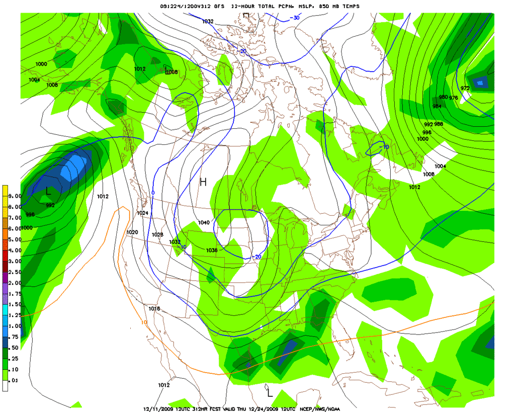
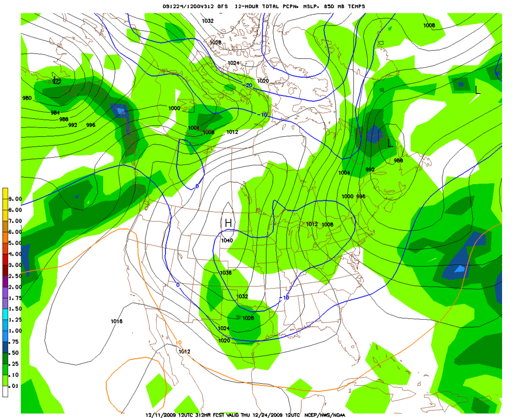
Where is that Bing Crosby music coming from? Is that you SG? Hmmm... :cheesy: :P

Parallel GFS
Image

Regular GFS
Image
0 likes   
Carla/Alicia/Jerry(In The Eye)/Michelle/Charley/Ivan/Dennis/Katrina/Rita/Wilma/Ike/Harvey

Member: National Weather Association
Wx Infinity Forums
http://wxinfinity.com/index.php

Facebook.com/WeatherInfinity
Twitter @WeatherInfinity

User avatar
southerngale
Retired Staff
Retired Staff
Posts: 27418
Joined: Thu Oct 10, 2002 1:27 am
Location: Southeast Texas (Beaumont area)

#510 Postby southerngale » Fri Dec 11, 2009 2:07 pm

You know it, srain! You better be careful though... you keep this up and I'm gonna start expecting some results. I'll have to hold you accountable, ya know. ;)
0 likes   
Please support Storm2k by making a donation today. It is greatly appreciated! Click here: Image

Image my Cowboys Image my RocketsImage my Astros

Burn1
Tropical Storm
Tropical Storm
Posts: 211
Joined: Sat Aug 28, 2004 10:13 pm

Re: SE TX/SW LA winter wx:Let it Snow! Let it Snow! Let it Snow!

#511 Postby Burn1 » Fri Dec 11, 2009 2:37 pm

If its cold in Texas.....It's warm in Florida! Below avg temps forecast for Florida this winter with El Nino......Not officially winter yet, but setting Hi records every day.....We will take the warm and sun 8-)
0 likes   

User avatar
srainhoutx
S2K Supporter
S2K Supporter
Posts: 6919
Age: 67
Joined: Sun Jan 14, 2007 11:34 am
Location: Haywood County, NC
Contact:

Re:

#512 Postby srainhoutx » Fri Dec 11, 2009 5:36 pm

southerngale wrote:You know it, srain! You better be careful though... you keep this up and I'm gonna start expecting some results. I'll have to hold you accountable, ya know. ;)


"Every dog has his day" and just like a clock, it's right twice a day! :P :lol: :wink: :cheesy: Actually, this will probably be the biggest bust ever! At least it is Winter and not Tropical though. :wink:
0 likes   
Carla/Alicia/Jerry(In The Eye)/Michelle/Charley/Ivan/Dennis/Katrina/Rita/Wilma/Ike/Harvey

Member: National Weather Association
Wx Infinity Forums
http://wxinfinity.com/index.php

Facebook.com/WeatherInfinity
Twitter @WeatherInfinity

User avatar
Ntxw
Storm2k Moderator
Storm2k Moderator
Posts: 22785
Joined: Wed Oct 21, 2009 6:34 pm
Location: DFW, Texas

#513 Postby Ntxw » Fri Dec 11, 2009 5:57 pm

With that it's for Christmas :lol: adds fuel to the fire, stakes are quite high
0 likes   
The above post and any post by Ntxw is NOT an official forecast and should not be used as such. It is just the opinion of the poster and may or may not be backed by sound meteorological data. It is NOT endorsed by any professional institution including Storm2k. For official information, please refer to NWS products.

  Help support Storm2K!
Help Support Storm2K

User avatar
wxgirl69
Tropical Storm
Tropical Storm
Posts: 120
Age: 55
Joined: Wed Nov 18, 2009 9:32 pm
Location: Deer Park, Texas

Re: Re:

#514 Postby wxgirl69 » Fri Dec 11, 2009 7:56 pm

srainhoutx wrote:
southerngale wrote:You know it, srain! You better be careful though... you keep this up and I'm gonna start expecting some results. I'll have to hold you accountable, ya know. ;)
"Every dog has his day" and just like a clock, it's right twice a day! :P :lol: :wink: :cheesy: Actually, this will probably be the biggest bust ever! At least it is Winter and not Tropical though. :wink


When you say biggest bust ever.. Are you referring to no cold for Christmas?


*edited by sg to fix the quotes
0 likes   

User avatar
srainhoutx
S2K Supporter
S2K Supporter
Posts: 6919
Age: 67
Joined: Sun Jan 14, 2007 11:34 am
Location: Haywood County, NC
Contact:

Re: SE TX/SW LA winter wx:Let it Snow! Let it Snow! Let it Snow!

#515 Postby srainhoutx » Fri Dec 11, 2009 10:20 pm

Getting lots of thunder with elevated thunderstorms and light rain so far, in NW Harris County tonight...a bit chilly as well. :cold:

http://radar.weather.gov/radar.php?rid= ... 1&loop=yes
0 likes   
Carla/Alicia/Jerry(In The Eye)/Michelle/Charley/Ivan/Dennis/Katrina/Rita/Wilma/Ike/Harvey

Member: National Weather Association
Wx Infinity Forums
http://wxinfinity.com/index.php

Facebook.com/WeatherInfinity
Twitter @WeatherInfinity

User avatar
srainhoutx
S2K Supporter
S2K Supporter
Posts: 6919
Age: 67
Joined: Sun Jan 14, 2007 11:34 am
Location: Haywood County, NC
Contact:

Re: SE TX/SW LA winter wx:Let it Snow! Let it Snow! Let it Snow!

#516 Postby srainhoutx » Sat Dec 12, 2009 1:29 pm

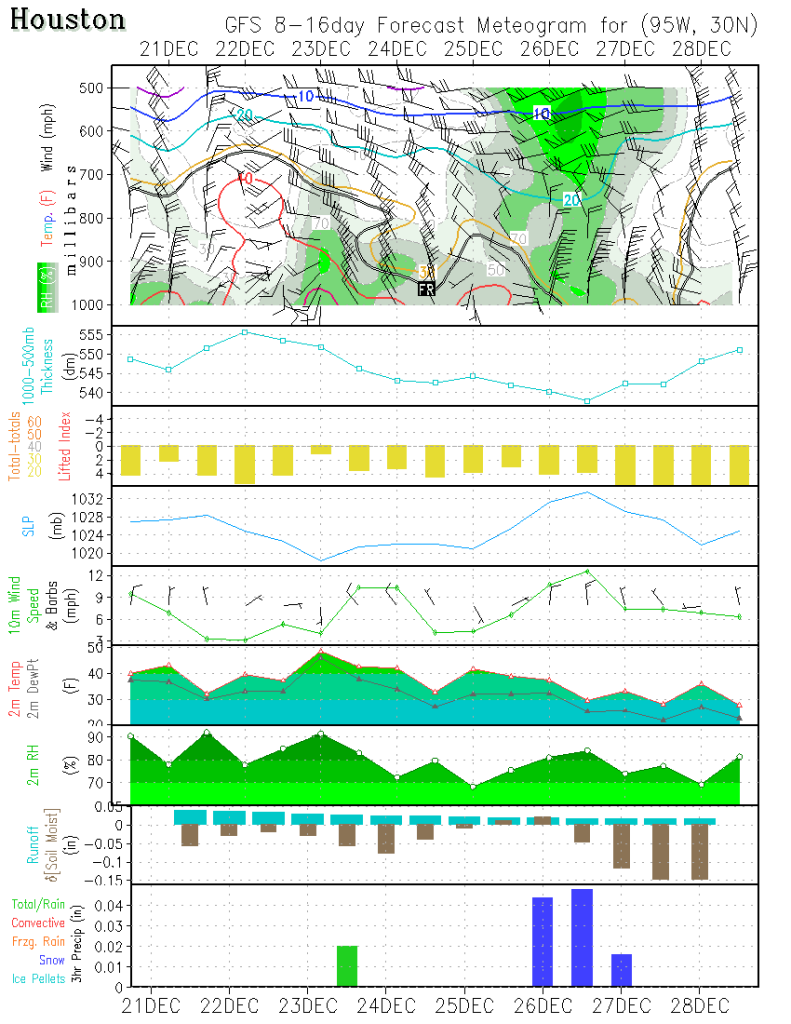
Not too terribly worried about timing, but the GFS continues the trend. The finer details will be worked out in the days ahead. :wink:

Image
0 likes   
Carla/Alicia/Jerry(In The Eye)/Michelle/Charley/Ivan/Dennis/Katrina/Rita/Wilma/Ike/Harvey

Member: National Weather Association
Wx Infinity Forums
http://wxinfinity.com/index.php

Facebook.com/WeatherInfinity
Twitter @WeatherInfinity

User avatar
southerngale
Retired Staff
Retired Staff
Posts: 27418
Joined: Thu Oct 10, 2002 1:27 am
Location: Southeast Texas (Beaumont area)

#517 Postby southerngale » Sat Dec 12, 2009 1:36 pm

A white Christmas... a white day or two after Christmas... I don't think you'd hear many complaints from the deep south on timing.... just let it snow!
0 likes   
Please support Storm2k by making a donation today. It is greatly appreciated! Click here: Image

Image my Cowboys Image my RocketsImage my Astros

User avatar
Sjones
Tropical Storm
Tropical Storm
Posts: 168
Joined: Thu May 17, 2007 2:09 pm
Location: Southeast Texas

Re:

#518 Postby Sjones » Sat Dec 12, 2009 3:12 pm

southerngale wrote:A white Christmas... a white day or two after Christmas... I don't think you'd hear many complaints from the deep south on timing.... just let it snow!


Amen to that!!! I would be hoping for some serious accumulation though...hehehe....any suggestions on that? I don't want to build a handheld snowman!!! :froze:
0 likes   

User avatar
vbhoutex
Storm2k Executive
Storm2k Executive
Posts: 29112
Age: 73
Joined: Wed Oct 09, 2002 11:31 pm
Location: Cypress, TX
Contact:

Re: Re:

#519 Postby vbhoutex » Sat Dec 12, 2009 4:47 pm

Sjones wrote:
southerngale wrote:A white Christmas... a white day or two after Christmas... I don't think you'd hear many complaints from the deep south on timing.... just let it snow!


Amen to that!!! I would be hoping for some serious accumulation though...hehehe....any suggestions on that? I don't want to build a handheld snowman!!! :froze:

I'm not one to raise hopes falsely, especially this far out on the models, but IF THE MODELS VERIFY, AND I EMPHASIZE THE IF and we use a 10:1 ration of precipitable liquid to snow, as suggested in the models we could be looking at several inches of snow over the 1.5-2 days winter precipitation is suggested. Honestly I am not sure I stated this all correctly, but the basics are that IF the models verify that is probably what we would see for amounts/accumulation.
0 likes   
Skywarn, C.E.R.T.
Please click below to donate to STORM2K to help with the expenses of keeping the site going:
Image

User avatar
Sjones
Tropical Storm
Tropical Storm
Posts: 168
Joined: Thu May 17, 2007 2:09 pm
Location: Southeast Texas

Re: SE TX/SW LA winter wx:Let it Snow! Let it Snow! Let it Snow!

#520 Postby Sjones » Sat Dec 12, 2009 5:10 pm

<--- is crossing her fingers, hoping, wishing, and praying!!! :ggreen:
0 likes   


Return to “Winter Weather”

Who is online

Users browsing this forum: No registered users and 10 guests