SE TX/SW LA Winter WX - 2011-2012

Winter Weather Discussion

Moderator: S2k Moderators

Forum rules

The posts in this forum are NOT official forecast and should not be used as such. They are just the opinion of the poster and may or may not be backed by sound meteorological data. They are NOT endorsed by any professional institution or STORM2K.

Help Support Storm2K
Message
Author
User avatar
southerngale
Retired Staff
Retired Staff
Posts: 27418
Joined: Thu Oct 10, 2002 1:27 am
Location: Southeast Texas (Beaumont area)

#481 Postby southerngale » Sun Dec 06, 2009 2:20 am

The icy conditions overnight last night caused more than 100 wrecks in the Beaumont area, leaving one man dead, according to police on Saturday.
http://www.beaumontenterprise.com/news/ ... _dead.html


Why were so many people out driving??? Cars were sliding all over the place!


This was posted late Friday night (early Sat. morn.) on Fox4:

12/5 Weather Creating Dangerous Conditions For Drivers

Image

The freezing weather conditions are creating dangerous driving conditions.

Wrecks are being reported throughout Southeast Texas.

Bridges and overpasses in our viewing area have begun to freeze over, making them extremely dangerous.

The Texas Department of Transportation has begun to sand and gravel the bridges, and some of them will be closed during this process.

Beaumont is experiencing extreme icing conditions on its overpasses.

In the past few hours, more than 75 wrecks have been reported there.

One of the worst area's where vehicles are sliding off of the freeway and crashing onto the service road is Interstate 10 and Walden Road.

One of the major wrecks Beaumont police officers are working involves an 18-wheeler (pictured above). It has overturned in the westbound lanes of Interstate 10, near the downtown exit. That's over the Neches River. Fuel has spilled across the highway.

That wreck has shut down both the east and west bound lanes until hazardous material crews can clean up the fuel spill, and crews can repair the retainer wall. Police say the wait could be long for those stuck in the traffic, because truck is having to be torn apart.

In Port Arthur, ice is already on the MLK Bridge to Pleasure Island. Police have shut down the Rainbow Bridge (pictured left) and the Veterans Memorial Bridge.

These weather conditions will continue to worsen until temperatures rise above freezing.
0 likes   
Please support Storm2k by making a donation today. It is greatly appreciated! Click here: Image

Image my Cowboys Image my RocketsImage my Astros

attallaman

Re: SE TX/SW LA winter wx:Let it Snow! Let it Snow! Let it Snow!

#482 Postby attallaman » Sun Dec 06, 2009 3:45 am

PTPatrick wrote:Off topic but most Azaleas are hardy arent they? Heck I have seen them in Denver, and they certainly dont get covered here. They also never got covered in south mississippi when I lived there, even when we had those freak winter snaps when temps went into the teens. Hibiscus definately not hardy though unless you have a rose of sharon...SO why cover them? Had they thrown out fall blooms or something?


Believe it or not I have some really hardy things that still had blooms despite temps already dropping well into the teens over a month ago and some days with highs in the 20s back in october and november. I think they were phlox and purple salvia...of course salvia would survive a nuke.
I've never covered any of my azaleas and I have several Encore azaleas blooming right now but I don't get that much hard freezing weather here but if it's ever forecasted to drop into the teens here I do cover my sagos. We were forecasted to have a moderate freeze here tonight, it hasn't made it to 32 yet, it's 36 right now. I lost a big sago several years ago when during a 2 day period the low dropped to 15 degrees and the temperature stayed below 32 for 2 days. My washer, dryer and natural gas hot water tank are all located in my utility room which is outside the main part of the house in my carport, no heat out there so you can image if it was 15 degrees out under my carport it wasn't much warmer inside that utility room. I almost had another problem that year when I had no water coming out of my washer for at least one day but fortunately no pipe damage in my wall that year. It has never dropped to 15 again here since that time back in the 70's.
0 likes   

User avatar
Sjones
Tropical Storm
Tropical Storm
Posts: 168
Joined: Thu May 17, 2007 2:09 pm
Location: Southeast Texas

Re: SE TX/SW LA winter wx:Let it Snow! Let it Snow! Let it Snow!

#483 Postby Sjones » Mon Dec 07, 2009 10:01 am

Does Anyone Know If SE TX will have another snow event this winter? Any forsee-able forecasts yet?
0 likes   

User avatar
HarlequinBoy
Category 5
Category 5
Posts: 1400
Age: 34
Joined: Wed Nov 29, 2006 1:57 am
Location: Memphis

Re: SE TX/SW LA winter wx:Let it Snow! Let it Snow! Let it Snow!

#484 Postby HarlequinBoy » Mon Dec 07, 2009 11:47 am

Well, if climatology were any indicator it would be years before extreme southeast Texas saw anything, but as this weekend proved, climatology doesn't always work. :)
0 likes   

User avatar
southerngale
Retired Staff
Retired Staff
Posts: 27418
Joined: Thu Oct 10, 2002 1:27 am
Location: Southeast Texas (Beaumont area)

#485 Postby southerngale » Mon Dec 07, 2009 11:54 am

Mother Nature seems to defy climatology quite a bit lately. I'm interested as well... when does the GFS (Good For Snow) show our next snow event? :ggreen:
0 likes   
Please support Storm2k by making a donation today. It is greatly appreciated! Click here: Image

Image my Cowboys Image my RocketsImage my Astros

User avatar
srainhoutx
S2K Supporter
S2K Supporter
Posts: 6919
Age: 67
Joined: Sun Jan 14, 2007 11:34 am
Location: Haywood County, NC
Contact:

Re: SE TX/SW LA winter wx:Let it Snow! Let it Snow! Let it Snow!

#486 Postby srainhoutx » Mon Dec 07, 2009 12:24 pm

Keep an eye on the December 20th or so time frame. Maybe :cheesy: :wink:
0 likes   
Carla/Alicia/Jerry(In The Eye)/Michelle/Charley/Ivan/Dennis/Katrina/Rita/Wilma/Ike/Harvey

Member: National Weather Association
Wx Infinity Forums
http://wxinfinity.com/index.php

Facebook.com/WeatherInfinity
Twitter @WeatherInfinity

User avatar
southerngale
Retired Staff
Retired Staff
Posts: 27418
Joined: Thu Oct 10, 2002 1:27 am
Location: Southeast Texas (Beaumont area)

#487 Postby southerngale » Mon Dec 07, 2009 12:28 pm

hmmm... just in time for Christmas. I'll take it.
0 likes   
Please support Storm2k by making a donation today. It is greatly appreciated! Click here: Image

Image my Cowboys Image my RocketsImage my Astros

User avatar
vbhoutex
Storm2k Executive
Storm2k Executive
Posts: 29112
Age: 73
Joined: Wed Oct 09, 2002 11:31 pm
Location: Cypress, TX
Contact:

Re: SE TX/SW LA winter wx:Let it Snow! Let it Snow! Let it Snow!

#488 Postby vbhoutex » Mon Dec 07, 2009 12:33 pm

srainhoutx wrote:Keep an eye on the December 20th or so time frame. Maybe :cheesy: :wink:

That is now looking like a strong tease so I guess it could "bear watching". :cheesy: :ggreen: My Mom is supposed to fly in on the 21st so can I as for a little bit earlier possibility?
0 likes   
Skywarn, C.E.R.T.
Please click below to donate to STORM2K to help with the expenses of keeping the site going:
Image

User avatar
srainhoutx
S2K Supporter
S2K Supporter
Posts: 6919
Age: 67
Joined: Sun Jan 14, 2007 11:34 am
Location: Haywood County, NC
Contact:

Re: SE TX/SW LA winter wx:Let it Snow! Let it Snow! Let it Snow!

#489 Postby srainhoutx » Mon Dec 07, 2009 12:41 pm

vbhoutex wrote:
srainhoutx wrote:Keep an eye on the December 20th or so time frame. Maybe :cheesy: :wink:

That is now looking like a strong tease so I guess it could "bear watching". :cheesy: :ggreen: My Mom is supposed to fly in on the 21st so can I as for a little bit earlier possibility?


Well the Long Range 12Z GFS switched back to a "No Cold For You" scenario from the 00Z run. As you know, I think models are going to struggle with the pattern for awhile now. Looks goood for adding snowcover to our N though.
0 likes   
Carla/Alicia/Jerry(In The Eye)/Michelle/Charley/Ivan/Dennis/Katrina/Rita/Wilma/Ike/Harvey

Member: National Weather Association
Wx Infinity Forums
http://wxinfinity.com/index.php

Facebook.com/WeatherInfinity
Twitter @WeatherInfinity

User avatar
srainhoutx
S2K Supporter
S2K Supporter
Posts: 6919
Age: 67
Joined: Sun Jan 14, 2007 11:34 am
Location: Haywood County, NC
Contact:

Re: SE TX/SW LA winter wx:Let it Snow! Let it Snow! Let it Snow!

#490 Postby srainhoutx » Wed Dec 09, 2009 8:19 am

Morning e-mail from Jeff...

Very fast upper level flow will keep changes in the forecast about every 2-3 days.


Arctic boundary entering our central counties this morning and will be moving off the coast after sunrise. Strong cold air advection will onset and even under clearing skies, temperatures will struggle in the 50’s most of the day and even the upper 40’s over our northern counties given upstream air mass over the TX panhandle in the 10’s and 1’s. Clear skies and light winds tonight will result in a freeze are most locations…however last Saturday was our killing freeze and no advisories will be needed. Temperatures may not bottom out as cold as they could get given increasing high level cirrus late tonight.


Next strong short wave in this fast southern branch flow arrives into TX Friday with deepening coastal low formation over the NW Gulf of Mexico with extensive isentropic lift above the cold dome at the surface. Expect clouds to rapidly increase Thursday evening and then lower Thursday night as light rain breaks out as the now dry low level saturate. Expect widespread rains on Friday as the coastal low moves up the coast producing strong lift. Strong long fetch ENE winds will also raise tide levels along the upper Texas coast and do expect some issues at the same locations that have had several issues this fall…starting to sound like a broken record with these coastal low events! This go around temperatures, while cold, will be well above freezing and all the precipitation will fall as liquid…it is hard to believe but snow is still rare in these parts!


This system passes on quickly east by Friday evening with dry weather Saturday before the next fast moving short wave arrives early next week. Polar jet buckles with continued indications of a 1045mb+ high nosing into the northern high plains. Will onset strong isentropic processes late Sunday as yet another NW Gulf coastal low develops…this looks to be the breeding ground for a potentially intense Nor’ easter next week over the east coast and the key to helping drive the building arctic dome over the northern plains southward. Expect wet conditions Monday and Tuesday followed by a strong arctic air intrusion into TX. Will keep the coldest air NE of the state with the heart of the high headed more toward the Great Lakes and not due south…however such cold and dense air masses tend to drop southward faster than models show and tend to be colder. GFS has a high of 67 on Tuesday and 61 next Wednesday…will undercut these numbers by at least 10 degrees especially on Wednesday and that may not be cold enough. All rainfall should be east of the area prior to the onset of the cold air so once again everything should be liquid although an earlier arrival of the cold could result in freezing rain to our north.


Pattern looks cold and stormy leading up to Christmas and numerous short waves transverse the southern branch with multiple shots of cold arctic air in a favorable pattern for delivery. GFS is keying in on the 21-25 for a fairly significant cold air outbreak with lots of sub-tropical moisture and disturbances…could see several winter weather events across TX.
0 likes   
Carla/Alicia/Jerry(In The Eye)/Michelle/Charley/Ivan/Dennis/Katrina/Rita/Wilma/Ike/Harvey

Member: National Weather Association
Wx Infinity Forums
http://wxinfinity.com/index.php

Facebook.com/WeatherInfinity
Twitter @WeatherInfinity

User avatar
PTrackerLA
Category 5
Category 5
Posts: 5277
Age: 41
Joined: Thu Oct 10, 2002 8:40 pm
Location: Lafayette, LA

Re: SE TX/SW LA winter wx:Let it Snow! Let it Snow! Let it Snow!

#491 Postby PTrackerLA » Wed Dec 09, 2009 8:55 am

I like the idea of several winter weather events in these areas :D . Let's just hope Christmas has cold or at least seasonable temps this year, it was in the upper 70's last year!
0 likes   

User avatar
PTrackerLA
Category 5
Category 5
Posts: 5277
Age: 41
Joined: Thu Oct 10, 2002 8:40 pm
Location: Lafayette, LA

Re: SE TX/SW LA winter wx:Let it Snow! Let it Snow! Let it Snow!

#492 Postby PTrackerLA » Wed Dec 09, 2009 11:49 am

Image

10 days out and the 12z GFS shows another event. :ggreen:
0 likes   

User avatar
srainhoutx
S2K Supporter
S2K Supporter
Posts: 6919
Age: 67
Joined: Sun Jan 14, 2007 11:34 am
Location: Haywood County, NC
Contact:

Re: SE TX/SW LA winter wx:Let it Snow! Let it Snow! Let it Snow!

#493 Postby srainhoutx » Thu Dec 10, 2009 7:53 am

HGX has a great link on their main page to some post analysis Satellite Information on the SE TX/ SW LA Historic Snowfall on December 4th from CIMSS...enjoy...

http://cimss.ssec.wisc.edu/goes/blog/archives/4072
0 likes   
Carla/Alicia/Jerry(In The Eye)/Michelle/Charley/Ivan/Dennis/Katrina/Rita/Wilma/Ike/Harvey

Member: National Weather Association
Wx Infinity Forums
http://wxinfinity.com/index.php

Facebook.com/WeatherInfinity
Twitter @WeatherInfinity

User avatar
srainhoutx
S2K Supporter
S2K Supporter
Posts: 6919
Age: 67
Joined: Sun Jan 14, 2007 11:34 am
Location: Haywood County, NC
Contact:

Re: SE TX/SW LA winter wx:Let it Snow! Let it Snow! Let it Snow!

#494 Postby srainhoutx » Thu Dec 10, 2009 8:24 am

Morning e-mail from Jeff...

Highly active El Nino enhanced southern jet will send our next storm system into the region Friday-Saturday.


Short waves lined up over the eastern Pacific in an active southern branch jet stream, while cold air continues to advect southward from the plains. Freeze line is currently from near Cleveland to Tomball to Austin and may sag a tad southward yet this morning. Given increasing high level cirrus today and continued low level cold air advection on NE winds…temperatures will struggle to get out of the 40’s.


Shortwave runs aground the Baja region tonight and helps to induce the infamous NW Gulf surface low pressure on Friday (seems like every few days we get a NW Gulf surface low this Fall). Low and coastal trough looks to form along the low TX coast with strong 300K isentropic lift starting Friday morning and really ramping up Friday evening as 850mb winds turn south and overrun (upglide) the cold dome at the surface. Will see light rain/drizzle early become widespread showers by Friday afternoon with a few thunderstorms possible Friday night/early Saturday. Coastal low will track offshore the upper TX coast and toward the LA coast with any severe weather being out over the open Gulf waters. Will see highs only near 50 on Friday as clouds, rain, and NE winds keep cold air advection in place. Widespread rainfall amounts of .25-.75 will be common with isolated amounts of 1.50 inches possible especially along the coast.


Tides may also be an issue late Friday into Saturday as winds ramp up in the offshore waters as the coastal low approaches. For now it does not look as if any warning levels will be exceeded…but locations on Bolivar could have some standing water at high tide.


System exits east Saturday with skies clearing and near seasonal temperatures for a change after our stretch of below average days…this will be short lived however as strong polar boundary surges southward down the plains on the backside of our next storm due in Monday. This system looks to be similar to Friday’s event however the surface low may be closer to the coast and some of the area may get warm sectored…like last Tuesday. Strong polar front rushes in by Tuesday of next week and will go colder than the GFS as I do not believe it is handling the cold air all that great and the pattern with a 1040mb high over the plains favors this dense air mass to drop quickly southward and likely be colder than guidance suggests. Will continue to watch…but trends point toward an increasingly cold period from the middle to next week through Christmas with our active southern stream continuing.
0 likes   
Carla/Alicia/Jerry(In The Eye)/Michelle/Charley/Ivan/Dennis/Katrina/Rita/Wilma/Ike/Harvey

Member: National Weather Association
Wx Infinity Forums
http://wxinfinity.com/index.php

Facebook.com/WeatherInfinity
Twitter @WeatherInfinity

User avatar
southerngale
Retired Staff
Retired Staff
Posts: 27418
Joined: Thu Oct 10, 2002 1:27 am
Location: Southeast Texas (Beaumont area)

#495 Postby southerngale » Thu Dec 10, 2009 11:40 am

It's 10:40 am and only 38° right now. Brrrr! I had a low of 31°

Image
0 likes   
Please support Storm2k by making a donation today. It is greatly appreciated! Click here: Image

Image my Cowboys Image my RocketsImage my Astros

User avatar
srainhoutx
S2K Supporter
S2K Supporter
Posts: 6919
Age: 67
Joined: Sun Jan 14, 2007 11:34 am
Location: Haywood County, NC
Contact:

Re: SE TX/SW LA winter wx:Let it Snow! Let it Snow! Let it Snow!

#496 Postby srainhoutx » Thu Dec 10, 2009 1:53 pm

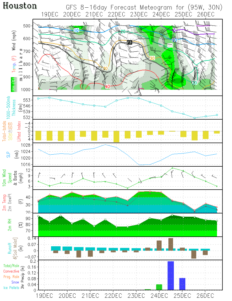
It's cold here too SG. Setting at 46 with NE winds at almost 1PM. :cold: Must be my age, but the cold air just cuts right through me. I almost froze last night trying to grill steaks outside. :cheesy: For grins and to get us in the Holiday Mood, this is the IAH La La Land GFS forecast for Christmas... :froze: :cold: :cheesy:

Image
0 likes   
Carla/Alicia/Jerry(In The Eye)/Michelle/Charley/Ivan/Dennis/Katrina/Rita/Wilma/Ike/Harvey

Member: National Weather Association
Wx Infinity Forums
http://wxinfinity.com/index.php

Facebook.com/WeatherInfinity
Twitter @WeatherInfinity

User avatar
southerngale
Retired Staff
Retired Staff
Posts: 27418
Joined: Thu Oct 10, 2002 1:27 am
Location: Southeast Texas (Beaumont area)

#497 Postby southerngale » Thu Dec 10, 2009 5:40 pm

I'm getting pretty decent with model maps (but a long ways to go), now that I finally started trying to understand them after all these years of just letting someone explain them to me, but can you elaborate on that? :uarrow:

I see the snow. Is that all I really need to take away from it? If so... all I want for Christmas is that!
0 likes   
Please support Storm2k by making a donation today. It is greatly appreciated! Click here: Image

Image my Cowboys Image my RocketsImage my Astros

User avatar
wxgirl69
Tropical Storm
Tropical Storm
Posts: 120
Age: 55
Joined: Wed Nov 18, 2009 9:32 pm
Location: Deer Park, Texas

Re: SE TX/SW LA winter wx:Let it Snow! Let it Snow! Let it Snow!

#498 Postby wxgirl69 » Thu Dec 10, 2009 5:57 pm

:uarrow: I likey the model reading.. We shall see.. I have been reading about cold air around Christmas.. Long way away.. I am keeping my fingers crossed.
0 likes   

User avatar
srainhoutx
S2K Supporter
S2K Supporter
Posts: 6919
Age: 67
Joined: Sun Jan 14, 2007 11:34 am
Location: Haywood County, NC
Contact:

Re: SE TX/SW LA winter wx:Let it Snow! Let it Snow! Let it Snow!

#499 Postby srainhoutx » Thu Dec 10, 2009 6:07 pm

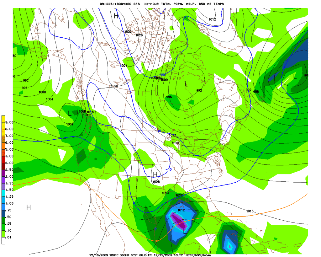
Well all the "fine details" will be worked out in the days ahead, but even the 18Z Parallel GFS likes a "wintry weather storm" idea for Christmas. :double: :eek: :D We shall see... :wink:

Image
0 likes   
Carla/Alicia/Jerry(In The Eye)/Michelle/Charley/Ivan/Dennis/Katrina/Rita/Wilma/Ike/Harvey

Member: National Weather Association
Wx Infinity Forums
http://wxinfinity.com/index.php

Facebook.com/WeatherInfinity
Twitter @WeatherInfinity

wgdade
Professional-Met
Professional-Met
Posts: 23
Joined: Sat Dec 05, 2009 9:32 pm
Location: Tyler, TX
Contact:

Re: SE TX/SW LA winter wx:Let it Snow! Let it Snow! Let it Snow!

#500 Postby wgdade » Thu Dec 10, 2009 6:32 pm

I don't wont to sound too negative because I love snow as much as the next but, the GFS always seems to have a winter storm, where you normally don't see snow, 10 to 14 days out in the winter. If you watch it too much is can get depressing. :cheesy:
0 likes   
W. Grant Dade
Good Morning East Texas/Midday Meteorologist
KLTV 7 Tyler, TX


Return to “Winter Weather”

Who is online

Users browsing this forum: No registered users and 13 guests