

ATL : TROPICAL DEPRESSION IDA
Moderator: S2k Moderators
-
cycloneye

- Admin

- Posts: 149829
- Age: 69
- Joined: Thu Oct 10, 2002 10:54 am
- Location: San Juan, Puerto Rico
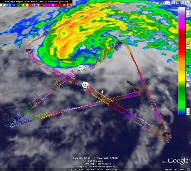
Re: ATL : TROPICAL STORM IDA - Recon
URNT15 KNHC 092048
AF303 0711A IDA HDOB 27 20091109
204030 2706N 08733W 8431 01541 0065 +175 +122 227039 040 029 000 00
204100 2707N 08731W 8428 01543 0065 +176 +118 225041 041 030 000 03
204130 2707N 08729W 8432 01540 0064 +178 +121 220040 041 028 000 00
204200 2708N 08727W 8429 01544 0064 +175 +128 219041 041 028 000 03
204230 2708N 08725W 8430 01545 0067 +174 +135 218043 044 028 000 03
204300 2708N 08723W 8428 01547 0070 +172 +138 217044 045 029 000 03
204330 2709N 08721W 8429 01548 0074 +169 +138 212045 046 027 000 00
204400 2709N 08719W 8430 01548 0071 +171 +137 208042 043 027 000 00
204430 2709N 08717W 8428 01551 0072 +171 +138 209041 042 028 000 00
204500 2710N 08714W 8431 01549 0074 +171 +141 207040 041 029 000 03
204530 2710N 08712W 8428 01552 0074 +170 +143 206040 040 029 000 00
204600 2710N 08710W 8430 01551 0077 +169 +145 205040 040 028 000 00
204630 2711N 08708W 8430 01556 0081 +165 +148 203038 039 026 000 03
204700 2712N 08708W 8431 01554 0082 +166 +150 200036 037 999 999 03
204730 2714N 08709W 8434 01548 0078 +170 +145 199035 036 028 000 03
204800 2715N 08710W 8429 01552 0074 +172 +141 199036 037 029 000 03
204830 2716N 08712W 8432 01549 0073 +173 +140 202037 038 029 000 00
204900 2717N 08713W 8429 01550 0073 +172 +139 204038 038 029 000 00
204930 2719N 08715W 8429 01548 0072 +173 +137 204037 037 031 000 00
205000 2720N 08716W 8427 01550 0071 +175 +134 204039 040 030 000 00
0 likes
Visit the Caribbean-Central America Weather Thread where you can find at first post web cams,radars
and observations from Caribbean basin members Click Here
and observations from Caribbean basin members Click Here
-
cycloneye
- Admin
- Posts: 149829
- Age: 69
- Joined: Thu Oct 10, 2002 10:54 am
- Location: San Juan, Puerto Rico
Re: ATL : TROPICAL STORM IDA
...SUMMARY OF 300 PM CST INFORMATION...
LOCATION...28.4N 88.5W
MAXIMUM SUSTAINED WINDS...70 MPH
PRESENT MOVEMENT...NORTH OR 355 DEGREES AT 18 MPH
MINIMUM CENTRAL PRESSURE...991 MB
LOCATION...28.4N 88.5W
MAXIMUM SUSTAINED WINDS...70 MPH
PRESENT MOVEMENT...NORTH OR 355 DEGREES AT 18 MPH
MINIMUM CENTRAL PRESSURE...991 MB
0 likes
Visit the Caribbean-Central America Weather Thread where you can find at first post web cams,radars
and observations from Caribbean basin members Click Here
and observations from Caribbean basin members Click Here
-
cycloneye
- Admin
- Posts: 149829
- Age: 69
- Joined: Thu Oct 10, 2002 10:54 am
- Location: San Juan, Puerto Rico
Re: ATL : TROPICAL STORM IDA - Advisories
000
WTNT41 KNHC 092056
TCDAT1
TROPICAL STORM IDA DISCUSSION NUMBER 24
NWS TPC/NATIONAL HURRICANE CENTER MIAMI FL AL112009
300 PM CST MON NOV 09 2009
WITH ONE INTERESTING EXCEPTION...THE LATEST REPORTS FROM AN AIR
FORCE RESERVE UNIT RECONNAISSANCE AIRCRAFT INDICATE THAT IDA
REMAINS JUST BELOW HURRICANE STRENGTH. A CONVECTIVE BURST THAT
BEGAN A FEW HOURS AGO HAS TEMPORARILY HALTED THE WEAKENING TREND.
PEAK 850 MB FLIGHT-LEVEL WINDS OF 75 KT AND PEAK SFMR WINDS OF 58
KT SUPPORT MAINTAINING THE ADVISORY INTENSITY AT 60 KT. ON THE MOST
RECENT OUTBOUND PASS...HOWEVER...THE SFMR DID REPORT A VERY SMALL
AREA OF 70-75 KT SURFACE WINDS SOUTHWEST OF THE CENTER JUST
DOWNWIND OF THE CONVECTIVE BURST. GIVEN THAT THE CONCURRENT
FLIGHT-LEVEL WINDS WERE ONLY 45 TO 55 KT...THIS APPEARS TO BE A
LOCAL CONVECTIVE-SCALE PEAK UNREPRESENTATIVE OF THE CIRCULATION.
SSTS BELOW THE CENTER ARE NOW ABOUT 26C...AND GET PROGRESSIVELY
COOLER ALONG THE PROJECTED TRACK. VERTICAL WIND SHEAR WILL ALSO BE
INCREASING OVER THE NEXT 12 HOURS OR SO. THE 12Z GLOBAL MODELS
STILL DO NOT SHOW MUCH IN THE WAY OF BAROCLINIC RE-INTENSIFICATION
PRIOR TO LANDFALL...AND SO A RESUMPTION OF THE EARLIER WEAKENING
TREND IS EXPECTED TO COMMENCE SOON.
IDA IS NOW MOVING NORTHWARD...355/16. THE DYNAMICAL GUIDANCE
INDICATES THAT THE FORWARD MOTION SHOULD SLOW APPRECIABLY OVER THE
NEXT 12 HOURS...BUT IF THE CONVECTION PERSISTS MUCH LONGER IDA WILL
LIKELY MOVE ON SHORE SOONER THAN FORECAST. MY OFFICIAL 12 HOUR
FORECAST POINT IS ALREADY AHEAD OF MOST OF THE GUIDANCE. THE
REMAINDER OF THE FORECAST IS SIMILAR TO THE PREVIOUS ADVISORY
TRACK...AND CALLS FOR IDA TO TURN EASTWARD AFTER LANDFALL AS IT
BECOMES EMBEDDED WITHIN A MID-LATITUDE TROUGH MOVING EASTWARD FROM
THE WESTERN GULF.
STRONG WINDS COVER A LARGE AREA OF THE GULF OF MEXICO AND RAINBANDS
ARE ALREADY MOVING ONSHORE WELL AHEAD OF THE CENTER. GIVEN THE
CURRENT MOTION AND CONVECTIVE VIGOR...IDA SHOULD MAINTAIN TROPICAL
CHARACTERISTICS THROUGH LANDFALL.
FORECAST POSITIONS AND MAX WINDS
INITIAL 09/2100Z 28.4N 88.5W 60 KT
12HR VT 10/0600Z 30.2N 88.1W 50 KT
24HR VT 10/1800Z 31.0N 87.1W 40 KT...INLAND
36HR VT 11/0600Z 31.0N 85.5W 30 KT...EXTRATROPICAL
48HR VT 11/1800Z 30.0N 83.5W 25 KT...EXTRATROPICAL
72HR VT 12/1800Z...DISSIPATED
$$
FORECASTER FRANKLIN
0 likes
Visit the Caribbean-Central America Weather Thread where you can find at first post web cams,radars
and observations from Caribbean basin members Click Here
and observations from Caribbean basin members Click Here
Re: ATL : TROPICAL STORM IDA
I think the growing eye is moving N now even though the convection looks like it is still a touch west.
0 likes
-
cycloneye
- Admin
- Posts: 149829
- Age: 69
- Joined: Thu Oct 10, 2002 10:54 am
- Location: San Juan, Puerto Rico
Re: ATL : TROPICAL STORM IDA
A CONVECTIVE BURST THAT
BEGAN A FEW HOURS AGO HAS TEMPORARILY HALTED THE WEAKENING TREND.
PEAK 850 MB FLIGHT-LEVEL WINDS OF 75 KT AND PEAK SFMR WINDS OF 58
KT SUPPORT MAINTAINING THE ADVISORY INTENSITY AT 60 KT. ON THE MOST
RECENT OUTBOUND PASS...HOWEVER...THE SFMR DID REPORT A VERY SMALL
AREA OF 70-75 KT SURFACE WINDS SOUTHWEST OF THE CENTER JUST
DOWNWIND OF THE CONVECTIVE BURST. GIVEN THAT THE CONCURRENT
FLIGHT-LEVEL WINDS WERE ONLY 45 TO 55 KT...THIS APPEARS TO BE A
LOCAL CONVECTIVE-SCALE PEAK UNREPRESENTATIVE OF THE CIRCULATION.
0 likes
Visit the Caribbean-Central America Weather Thread where you can find at first post web cams,radars
and observations from Caribbean basin members Click Here
and observations from Caribbean basin members Click Here


Re: ATL : TROPICAL STORM IDA
If Ida remains on the current (3pm) forecast track, will this be the first landfalling November tropical storm in Alabama?
0 likes

Re: ATL : TROPICAL STORM IDA
they should bring back the hurricane warnings to be on the safe side. What is it going to hurt? Immediate coast will probably see gusts in the cat 1 range anyway.
0 likes
-
lrak

- S2K Supporter

- Posts: 1770
- Age: 59
- Joined: Thu Jun 21, 2007 2:48 pm
- Location: Corpus Christi, TX
Re: ATL : TROPICAL STORM IDA
Take care northern GOMERS! Ida and company have really churned up the GOM and coastal flood advisories everywhere.
0 likes
AKA karl
Also
Personal Forecast Disclaimer:
My posts on this forum are NOT official forecast and should not be used as such. My posts are my basic observations and are definitely not backed by any "well some" meteorological knowledge. For official information, please refer to the NHC and NWS products.
Also
Personal Forecast Disclaimer:
My posts on this forum are NOT official forecast and should not be used as such. My posts are my basic observations and are definitely not backed by any "well some" meteorological knowledge. For official information, please refer to the NHC and NWS products.
-
cycloneye
- Admin
- Posts: 149829
- Age: 69
- Joined: Thu Oct 10, 2002 10:54 am
- Location: San Juan, Puerto Rico
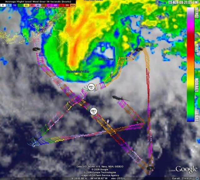
Re: ATL : TROPICAL STORM IDA - Recon
URNT15 KNHC 092058
AF303 0711A IDA HDOB 28 20091109
205030 2721N 08717W 8429 01548 0067 +178 +131 209040 041 030 000 03
205100 2722N 08719W 8430 01545 0063 +181 +127 206039 039 031 000 00
205130 2724N 08720W 8429 01545 0063 +180 +121 204038 039 031 000 00
205200 2725N 08721W 8430 01541 0064 +176 +118 204039 039 029 000 00
205230 2726N 08723W 8429 01543 0065 +172 +119 203040 041 030 000 00
205300 2727N 08724W 8430 01541 0066 +171 +127 208038 040 031 000 00
205330 2729N 08725W 8430 01539 0057 +181 +116 214038 038 033 000 00
205400 2730N 08727W 8430 01536 0058 +179 +116 215038 038 033 000 03
205430 2731N 08728W 8430 01536 0057 +177 +119 213038 038 033 000 03
205500 2732N 08729W 8429 01538 0054 +181 +114 208038 038 032 001 00
205530 2733N 08731W 8428 01536 0058 +171 +125 204037 038 032 000 00
205600 2735N 08732W 8430 01532 0060 +164 +129 205036 037 033 000 03
205630 2736N 08733W 8432 01529 0060 +158 +131 213038 040 033 000 00
205700 2737N 08735W 8429 01530 0057 +158 +132 218041 042 033 000 00
205730 2738N 08736W 8429 01527 0055 +158 +131 217042 042 032 000 00
205800 2739N 08737W 8432 01524 0056 +157 +132 213041 041 030 000 00
205830 2741N 08739W 8429 01523 0052 +157 +133 207040 040 028 000 00
205900 2742N 08740W 8430 01522 0051 +155 +133 207043 045 030 000 00
205930 2743N 08741W 8429 01521 0049 +157 +131 207046 047 031 000 00
210000 2744N 08743W 8431 01517 0043 +163 +132 210049 050 034 000 00
0 likes
Visit the Caribbean-Central America Weather Thread where you can find at first post web cams,radars
and observations from Caribbean basin members Click Here
and observations from Caribbean basin members Click Here

Re: ATL : TROPICAL STORM IDA
ROCK wrote:they should bring back the hurricane warnings to be on the safe side. What is it going to hurt? Immediate coast will probably see gusts in the cat 1 range anyway.
I don't see what there is to gain in upgrading the warnings from TS to Hurricane.
Preparations have to all be done by now and you don't do anything differently when you expect 75-80 MPH winds vs. 65-70.
It really is now down to only being a question of semantics.
Makes no practical difference in my opininion
0 likes
-
Janie2006

- Category 5

- Posts: 1329
- Joined: Mon Sep 18, 2006 3:28 pm
- Location: coastal Ms aka home of the hurricanes
Re: ATL : TROPICAL STORM IDA
I was just watching Cantore's live shot from Pensacola Beach, where the lifeguards were in an apparent frenzy trying to reach someone in trouble. The person in question turned out to be fine, but there's a strong lesson here. Geez, now Cantore is interviewing the guy.
Folks, it's common sense. Just stay out of the water when tropical systems approach the coast. Even Olympic swimmers are not strong enough to fight a rip current. Conditions will continue to deteriorate from here and it just isn't worth it.
Folks, it's common sense. Just stay out of the water when tropical systems approach the coast. Even Olympic swimmers are not strong enough to fight a rip current. Conditions will continue to deteriorate from here and it just isn't worth it.
0 likes

Re:
funster wrote:Looks the NHC and others were right to call for a hurricane even if it is not upgraded here at the end. Those calling for extratropical transition before landfall will have to put on a pair of sad pants, a silly hat, a failure scarf and eat crow as Ida has pwned them and made them look foolish.


(best I could do for sad pants)
Everyone be safe, and hope you don't mind I added some silliness to lighten the stress for those that may be affected. Mods, delete if you think it is inappropriate.
0 likes
-
cycloneye
- Admin
- Posts: 149829
- Age: 69
- Joined: Thu Oct 10, 2002 10:54 am
- Location: San Juan, Puerto Rico
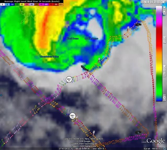
Re: ATL : TROPICAL STORM IDA - Recon
000
URNT15 KNHC 092108
AF303 0711A IDA HDOB 29 20091109
210030 2746N 08744W 8432 01515 0043 +160 +134 212049 050 031 000 00
210100 2747N 08745W 8425 01520 0041 +160 +131 214050 050 033 000 03
210130 2748N 08747W 8434 01509 0038 +162 +130 212048 049 031 000 00
210200 2749N 08748W 8428 01512 0034 +165 +126 209047 048 031 000 00
210230 2750N 08750W 8429 01510 0031 +167 +126 209050 051 030 000 03
210300 2752N 08751W 8429 01506 0027 +169 +125 207051 051 027 000 00
210330 2753N 08752W 8428 01507 0023 +176 +120 210044 047 027 000 03
210400 2754N 08754W 8430 01502 0017 +184 +118 215047 048 028 000 00
210430 2755N 08755W 8428 01504 0011 +190 +118 212049 049 029 000 00
210500 2756N 08756W 8433 01495 0006 +193 +116 210048 049 027 000 00
210530 2758N 08758W 8425 01502 0004 +193 +115 209049 051 028 000 00
210600 2759N 08759W 8431 01493 9997 +202 +104 214045 046 030 000 00
210630 2800N 08800W 8430 01491 9993 +205 +103 213046 048 030 000 00
210700 2801N 08802W 8437 01482 9987 +206 +104 210049 051 030 000 00
210730 2803N 08803W 8426 01490 9984 +208 +108 207047 048 029 002 00
210800 2804N 08804W 8434 01477 9976 +215 +103 205049 052 031 000 00
210830 2805N 08806W 8431 01477 9969 +218 +107 206058 059 030 002 00
210900 2806N 08807W 8427 01476 9963 +220 +106 207058 059 032 002 00
210930 2808N 08809W 8429 01471 9958 +221 +100 213059 061 032 000 00
211000 2809N 08810W 8427 01464 9944 +233 +088 217056 057 032 000 00
$$
0 likes
Visit the Caribbean-Central America Weather Thread where you can find at first post web cams,radars
and observations from Caribbean basin members Click Here
and observations from Caribbean basin members Click Here
-
vbhoutex

- Storm2k Executive
- Posts: 29151
- Age: 74
- Joined: Wed Oct 09, 2002 11:31 pm
- Location: Cypress, TX
- Contact:
Re: ATL : TROPICAL STORM IDA
Janie2006 wrote:I was just watching Cantore's live shot from Pensacola Beach, where the lifeguards were in an apparent frenzy trying to reach someone in trouble. The person in question turned out to be fine, but there's a strong lesson here. Geez, now Cantore is interviewing the guy.
Folks, it's common sense. Just stay out of the water when tropical systems approach the coast. Even Olympic swimmers are not strong enough to fight a rip current. Conditions will continue to deteriorate from here and it just isn't worth it.
It doesn't even have to be approaching the coast. In 1970 as Hurricane Celia passed hundreds of miles South of P'cola Beach me and 3 friends learned our lesson the hard way. 3 broken surf boards(mine survived) and 4 near drownings. I was the closest to our entry point when I finally got ashore 1\4 mile down the beach. The others were at least a mile and until we were able to crawl back to the car we weren't even sure if each other had survived. Had 3 awesome rides in 4 hours and one near death experience. As much as I loved surfing, I never did that again.
Now back to current Ida information.
0 likes
Skywarn, C.E.R.T.
Please click below to donate to STORM2K to help with the expenses of keeping the site going:

Please click below to donate to STORM2K to help with the expenses of keeping the site going:
-
southerngale

- Retired Staff

- Posts: 27418
- Joined: Thu Oct 10, 2002 1:27 am
- Location: Southeast Texas (Beaumont area)
Re: ATL : TROPICAL STORM IDA
lostsole wrote:You guys realize this storm is nothing much at all. No reason to have a hurricane watch or warning, that is absurd, and as far as rainfall we get more than 12 inches at least 3-4 times a year so 4-6 is nothing more than a good summer thunderstorm system. The waves are up, but there is no storm surge. The hype is over, there is nothing to see here.
--Lostsole, over and out.
There's a strong tropical storm approaching the Gulf coast. Don't trivialize it with comments like this. It is something to those who are affected by a strong TS along the Gulf coast in November! If there's nothing to see here, feel free to move along.
0 likes
Please support Storm2k by making a donation today. It is greatly appreciated! Click here:
 my Cowboys my Rockets my Astros
my Cowboys my Rockets my AstrosWho is online
Users browsing this forum: No registered users and 40 guests