

Here's a new report before I head out to lunch:
URNT15 KNHC 041734
AF303 0111A CYCLONE HDOB 15 20091104
172630 2043N 08538W 3444 08670 0442 -242 -247 239015 019 037 007 00
172700 2040N 08536W 3459 08634 0441 -237 +999 240016 018 026 015 01
172730 2038N 08535W 3441 08679 0444 -242 -246 251018 021 016 000 03
172800 2036N 08534W 3441 08679 0444 -242 -254 247012 014 018 000 03
172830 2034N 08533W 3442 08673 0443 -245 -247 250011 012 015 000 01
172900 2031N 08532W 3443 08674 0444 -241 +999 259007 008 010 000 01
172930 2029N 08530W 3441 08679 0444 -240 +999 272007 007 008 000 01
173000 2027N 08529W 3441 08668 0438 -241 -244 230011 015 009 000 00
173030 2025N 08528W 3439 08682 0445 -242 -243 235017 018 012 000 03
173100 2023N 08527W 3445 08671 0446 -244 -253 225021 022 009 000 03
173130 2020N 08525W 3442 08676 0445 -245 -257 229021 022 016 000 00
173200 2018N 08524W 3443 08674 0446 -243 -279 225022 023 018 000 00
173230 2016N 08523W 3443 08676 0447 -240 -295 230021 022 017 000 00
173300 2014N 08522W 3442 08678 0448 -240 -297 234020 021 017 000 00
173330 2012N 08521W 3443 08677 0448 -240 -296 238019 020 018 000 00
173400 2009N 08519W 3443 08678 0450 -242 -297 239019 020 018 000 03
173430 2007N 08518W 3443 08678 0450 -246 -292 238019 020 020 000 03
173500 2005N 08517W 3439 08683 0448 -247 -295 236019 019 019 000 03
173530 2003N 08516W 3441 08686 0447 -246 -300 229021 022 019 000 03
173600 2000N 08515W 3442 08681 0448 -246 -298 229020 021 018 000 03
ATL : TROPICAL DEPRESSION IDA
Moderator: S2k Moderators
-
ozonepete
- Professional-Met

- Posts: 4743
- Joined: Mon Sep 07, 2009 3:23 pm
- Location: From Ozone Park, NYC / Now in Brooklyn, NY
Re: ATL : TROPICAL DEPRESSION ELEVEN
Looks to me that it's still going northwest, but very slowly. I'm really curious what RECON finds for the motion as well as intensity.
0 likes
-
cycloneye

- Admin

- Posts: 149825
- Age: 69
- Joined: Thu Oct 10, 2002 10:54 am
- Location: San Juan, Puerto Rico
Re: ATL : TROPICAL DEPRESSION ELEVEN
Evil Jeremy wrote:I don't see how this is going to miss land. I would be surprised to see it survive the trip into the NW Caribbean.
GFDL doesnt agree.
0 likes
Visit the Caribbean-Central America Weather Thread where you can find at first post web cams,radars
and observations from Caribbean basin members Click Here
and observations from Caribbean basin members Click Here
-
ozonepete
- Professional-Met
- Posts: 4743
- Joined: Mon Sep 07, 2009 3:23 pm
- Location: From Ozone Park, NYC / Now in Brooklyn, NY
Re: ATL : TROPICAL DEPRESSION ELEVEN
Where's Ivanhater? Did you see that the 12Z CMC has it going in over Pensacola next Tuesday?  (Yeah I know that model is often way off, especially on intensity. But I thought you'd get a kick out of it.)
0 likes


Re: ATL : TROPICAL DEPRESSION ELEVEN - Models
Pretty good model consensus taking TD 11 into the south-central GOM in 5 days. You have 12Z GFS, GFDL, and CMC all on board with a similar track. Have to wait on the Euro to see if its 4 out of 4.
0 likes
-
IvanSurvivor
- Tropical Storm

- Posts: 152
- Joined: Wed Aug 20, 2008 12:12 am
- Location: Pensacola Florida (Warrington)
Re: ATL : TROPICAL DEPRESSION ELEVEN - Models
Ivanhater wrote:wow
We take one for the team way to much around here! LOL
0 likes
-
Derek Ortt
-
cycloneye
- Admin
- Posts: 149825
- Age: 69
- Joined: Thu Oct 10, 2002 10:54 am
- Location: San Juan, Puerto Rico
Re: ATL : TROPICAL DEPRESSION ELEVEN - Advisories
CZC MIATCPAT1 ALL
TTAA00 KNHC DDHHMM
BULLETIN
TROPICAL DEPRESSION ELEVEN INTERMEDIATE ADVISORY NUMBER 1A
NWS TPC/NATIONAL HURRICANE CENTER MIAMI FL AL112009
100 PM EST WED NOV 04 2009
...TROPICAL DEPRESSION CLOSE TO TROPICAL STORM STRENGTH...AIR FORCE
PLANE IS EN ROUTE...
A TROPICAL STORM WARNING REMAINS IN EFFECT FOR THE ENTIRE EASTERN
COAST OF NICARAGUA AND FOR THE ISLANDS OF SAN ANDRES AND
PROVIDENCIA. A TROPICAL STORM WARNING MEANS THAT TROPICAL STORM
CONDITIONS ARE EXPECTED SOMEWHERE WITHIN THE WARNING AREA WITHIN 24
HOURS.
FOR STORM INFORMATION SPECIFIC TO YOUR AREA...PLEASE MONITOR
PRODUCTS ISSUED BY YOUR NATIONAL METEOROLOGICAL SERVICE.
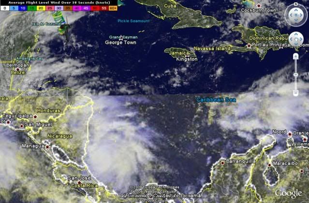
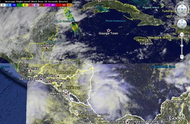
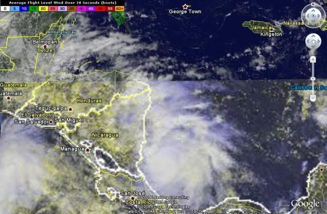
AT 100 PM EST...1800 UTC...THE CENTER OF TROPICAL DEPRESSION ELEVEN
WAS LOCATED NEAR LATITUDE 11.8 NORTH...LONGITUDE 82.3 WEST OR ABOUT
65 MILES...105 KM...SOUTHWEST OF SAN ANDRES ISLAND AND ABOUT
100 MILES...160 KM...EAST OF BLUEFIELDS NICARAGUA.
THE DEPRESSION HAS BEEN MOVING TOWARD THE WEST-NORTHWEST NEAR 7
MPH...11 KM/HR...BUT A SLOWER MOTION IS EXPECTED LATER TODAY WITH A
TURN TOWARD THE NORTHWEST. ON THE FORECAST TRACK THE CENTER OF THE
DEPRESSION WILL BE NEAR THE EAST COAST OF NICARAGUA THIS EVENING.
MAXIMUM SUSTAINED WINDS ARE NEAR 35 MPH...55 KM/HR...WITH HIGHER
GUSTS. THE DEPRESSION IS EXPECTED TO BECOME A TROPICAL STORM LATER
THIS AFTERNOON AND FURTHER STRENGTHENING IS EXPECTED UNTIL LANDFALL.
THE ESTIMATED MINIMUM CENTRAL PRESSURE IS 1006 MB...29.71 INCHES.
THE DEPRESSION IS EXPECTED TO PRODUCE TOTAL RAINFALL ACCUMULATIONS
OF 5 TO 7 INCHES OVER SAN ANDRES ISLAND WITH MAXIMUM AMOUNTS OF 12
INCHES POSSIBLE. RAINFALL ACCUMULATIONS OF 15 TO 20 INCHES ARE
EXPECTED OVER EASTERN NICARAGUA AND EASTERN HONDURAS WITH MAXIMUM
AMOUNTS OF 25 INCHES POSSIBLE. THESE RAINS COULD PRODUCE
LIFE-THREATENING FLASH FLOOD AND MUD SLIDES.
...SUMMARY OF 100 PM EST INFORMATION...
LOCATION...11.8N 82.3W
MAXIMUM SUSTAINED WINDS...35 MPH
PRESENT MOVEMENT...WEST-NORTHWEST OR 300 DEGREES AT 7 MPH
MINIMUM CENTRAL PRESSURE...1006 MB
THE NEXT ADVISORY WILL BE ISSUED BY THE NATIONAL HURRICANE CENTER AT
400 PM EST.
$$
FORECASTER BLAKE/FRANKLIN
TTAA00 KNHC DDHHMM
BULLETIN
TROPICAL DEPRESSION ELEVEN INTERMEDIATE ADVISORY NUMBER 1A
NWS TPC/NATIONAL HURRICANE CENTER MIAMI FL AL112009
100 PM EST WED NOV 04 2009
...TROPICAL DEPRESSION CLOSE TO TROPICAL STORM STRENGTH...AIR FORCE
PLANE IS EN ROUTE...
A TROPICAL STORM WARNING REMAINS IN EFFECT FOR THE ENTIRE EASTERN
COAST OF NICARAGUA AND FOR THE ISLANDS OF SAN ANDRES AND
PROVIDENCIA. A TROPICAL STORM WARNING MEANS THAT TROPICAL STORM
CONDITIONS ARE EXPECTED SOMEWHERE WITHIN THE WARNING AREA WITHIN 24
HOURS.
FOR STORM INFORMATION SPECIFIC TO YOUR AREA...PLEASE MONITOR
PRODUCTS ISSUED BY YOUR NATIONAL METEOROLOGICAL SERVICE.
AT 100 PM EST...1800 UTC...THE CENTER OF TROPICAL DEPRESSION ELEVEN
WAS LOCATED NEAR LATITUDE 11.8 NORTH...LONGITUDE 82.3 WEST OR ABOUT
65 MILES...105 KM...SOUTHWEST OF SAN ANDRES ISLAND AND ABOUT
100 MILES...160 KM...EAST OF BLUEFIELDS NICARAGUA.
THE DEPRESSION HAS BEEN MOVING TOWARD THE WEST-NORTHWEST NEAR 7
MPH...11 KM/HR...BUT A SLOWER MOTION IS EXPECTED LATER TODAY WITH A
TURN TOWARD THE NORTHWEST. ON THE FORECAST TRACK THE CENTER OF THE
DEPRESSION WILL BE NEAR THE EAST COAST OF NICARAGUA THIS EVENING.
MAXIMUM SUSTAINED WINDS ARE NEAR 35 MPH...55 KM/HR...WITH HIGHER
GUSTS. THE DEPRESSION IS EXPECTED TO BECOME A TROPICAL STORM LATER
THIS AFTERNOON AND FURTHER STRENGTHENING IS EXPECTED UNTIL LANDFALL.
THE ESTIMATED MINIMUM CENTRAL PRESSURE IS 1006 MB...29.71 INCHES.
THE DEPRESSION IS EXPECTED TO PRODUCE TOTAL RAINFALL ACCUMULATIONS
OF 5 TO 7 INCHES OVER SAN ANDRES ISLAND WITH MAXIMUM AMOUNTS OF 12
INCHES POSSIBLE. RAINFALL ACCUMULATIONS OF 15 TO 20 INCHES ARE
EXPECTED OVER EASTERN NICARAGUA AND EASTERN HONDURAS WITH MAXIMUM
AMOUNTS OF 25 INCHES POSSIBLE. THESE RAINS COULD PRODUCE
LIFE-THREATENING FLASH FLOOD AND MUD SLIDES.
...SUMMARY OF 100 PM EST INFORMATION...
LOCATION...11.8N 82.3W
MAXIMUM SUSTAINED WINDS...35 MPH
PRESENT MOVEMENT...WEST-NORTHWEST OR 300 DEGREES AT 7 MPH
MINIMUM CENTRAL PRESSURE...1006 MB
THE NEXT ADVISORY WILL BE ISSUED BY THE NATIONAL HURRICANE CENTER AT
400 PM EST.
$$
FORECASTER BLAKE/FRANKLIN
0 likes
Visit the Caribbean-Central America Weather Thread where you can find at first post web cams,radars
and observations from Caribbean basin members Click Here
and observations from Caribbean basin members Click Here
-
Dean4Storms
- S2K Supporter

- Posts: 6358
- Age: 63
- Joined: Sun Aug 31, 2003 1:01 pm
- Location: Miramar Bch. FL
-
cycloneye
- Admin
- Posts: 149825
- Age: 69
- Joined: Thu Oct 10, 2002 10:54 am
- Location: San Juan, Puerto Rico
Re: ATL : TROPICAL DEPRESSION ELEVEN
This is what I am worried about.
THE DEPRESSION IS EXPECTED TO PRODUCE TOTAL RAINFALL ACCUMULATIONS
OF 5 TO 7 INCHES OVER SAN ANDRES ISLAND WITH MAXIMUM AMOUNTS OF 12
INCHES POSSIBLE. RAINFALL ACCUMULATIONS OF 15 TO 20 INCHES ARE
EXPECTED OVER EASTERN NICARAGUA AND EASTERN HONDURAS WITH MAXIMUM
AMOUNTS OF 25 INCHES POSSIBLE. THESE RAINS COULD PRODUCE
LIFE-THREATENING FLASH FLOOD AND MUD SLIDES.
0 likes
Visit the Caribbean-Central America Weather Thread where you can find at first post web cams,radars
and observations from Caribbean basin members Click Here
and observations from Caribbean basin members Click Here
-
Ivanhater

- Storm2k Moderator

- Posts: 11222
- Age: 39
- Joined: Fri Jul 01, 2005 8:25 am
- Location: Pensacola
Re: ATL : TROPICAL DEPRESSION ELEVEN
ozonepete wrote:Where's Ivanhater? Did you see that the 12Z CMC has it going in over Pensacola next Tuesday?
Lol, I poked my head into the models thread. I doubt it will happen, but I can't believe we are talking about the possibility this late in the season, I was about to set up camp in the winter weather thread!
0 likes
Michael
-
cycloneye
- Admin
- Posts: 149825
- Age: 69
- Joined: Thu Oct 10, 2002 10:54 am
- Location: San Juan, Puerto Rico
Re: ATL : TROPICAL DEPRESSION ELEVEN - Models
12z HWRF is almost with the same track as GFDL and CMC.A Tropical Storm in GOM.
http://moe.met.fsu.edu/cgi-bin/hwrftc2. ... =Animation

http://moe.met.fsu.edu/cgi-bin/hwrftc2. ... =Animation
0 likes
Visit the Caribbean-Central America Weather Thread where you can find at first post web cams,radars
and observations from Caribbean basin members Click Here
and observations from Caribbean basin members Click Here
-
HURAKAN

- Professional-Met
- Posts: 46084
- Age: 39
- Joined: Thu May 20, 2004 4:34 pm
- Location: Key West, FL
- Contact:
452
URNT15 KNHC 041754
AF303 0111A CYCLONE HDOB 17 20091104
174630 1913N 08454W 3443 08677 0451 -240 -344 240017 018 038 022 03
174700 1910N 08453W 3441 08682 0452 -243 -349 238018 019 028 004 00
174730 1908N 08453W 3443 08682 0451 -240 -378 233019 019 026 000 03
174800 1906N 08452W 3442 08681 0452 -240 -367 221018 019 039 009 03
174830 1904N 08451W 3443 08666 0437 -237 -352 222015 017 032 028 03
174900 1901N 08449W 3444 08668 0445 -235 -310 243019 020 999 999 03
174930 1900N 08447W 3442 08670 0438 -239 -373 240018 019 999 999 03
175000 1858N 08446W 3442 08681 0441 -237 -376 236018 018 018 002 03
175030 1856N 08444W 3443 08679 0451 -235 -366 228019 020 025 002 00
175100 1854N 08442W 3442 08686 0456 -235 -406 226020 020 024 006 00
175130 1852N 08441W 3442 08688 0458 -235 -387 227018 018 032 008 00
175200 1850N 08439W 3443 08683 0456 -235 -390 231018 018 036 007 00
175230 1848N 08438W 3443 08690 0456 -235 -381 235017 019 027 004 00
175300 1845N 08437W 3441 08686 0457 -235 -391 235017 018 031 002 00
175330 1843N 08435W 3445 08680 0457 -235 -378 233018 019 034 006 00
175400 1841N 08434W 3442 08692 0458 -235 -398 233019 019 038 005 00
175430 1839N 08433W 3444 08688 0456 -233 -382 231018 018 034 009 03
175500 1837N 08432W 3442 08685 0454 -236 -381 233018 019 027 002 03
175530 1834N 08431W 3442 08685 0455 -238 -350 235017 017 020 000 03
175600 1832N 08430W 3441 08689 0455 -236 -358 241017 017 020 000 03
$$
;
0 likes
-
ozonepete
- Professional-Met
- Posts: 4743
- Joined: Mon Sep 07, 2009 3:23 pm
- Location: From Ozone Park, NYC / Now in Brooklyn, NY
Re: ATL : TROPICAL DEPRESSION ELEVEN
Ivanhater wrote:ozonepete wrote:Where's Ivanhater? Did you see that the 12Z CMC has it going in over Pensacola next Tuesday?
Lol, I poked my head into the models thread. I doubt it will happen, but I can't believe we are talking about the possibility this late in the season, I was about to set up camp in the winter weather thread!
Not so fast. LOL
0 likes
-
Comanche

- Category 1

- Posts: 381
- Age: 54
- Joined: Wed Jul 06, 2005 9:33 am
- Location: Clear Lake City Texas
Re: ATL : TROPICAL DEPRESSION ELEVEN
is recon flying yet? what is the schedule, and what time would we possibly know if it is being upgraded? Muchas gracias!
0 likes
-
tolakram
- Admin
- Posts: 20188
- Age: 62
- Joined: Sun Aug 27, 2006 8:23 pm
- Location: Florence, KY (name is Mark)
Re: ATL : TROPICAL DEPRESSION ELEVEN
Look at the recon thread in this forum.
Here's the Mimic TPW. More moisture on the way.
http://cimss.ssec.wisc.edu/tropic/real- ... /main.html
Here's the Mimic TPW. More moisture on the way.
http://cimss.ssec.wisc.edu/tropic/real- ... /main.html
0 likes
M a r k
- - - - -
Join us in chat: Storm2K Chatroom Invite. Android and IOS apps also available.
The posts in this forum are NOT official forecasts and should not be used as such. Posts are NOT endorsed by any professional institution or STORM2K.org. For official information and forecasts, please refer to NHC and NWS products.
Who is online
Users browsing this forum: No registered users and 12 guests