TPPN10 PGTW 292103
A. TYPHOON 23W (MIRINAE)
B. 29/2030Z
C. 15.2N
D. 126.9E
E. FIVE/MTSAT
F. N/A
G. IR/EIR
H. REMARKS: 46A/PBO EMBD CNTR/ANMTN.
I. ADDITIONAL POSITIONS:
29/1719Z 15.2N 127.6E MMHS
BRANDON
WPAC : TROPICAL DEPRESSION MIRINAE (23W)
Moderator: S2k Moderators
-
Aslkahuna

- Professional-Met

- Posts: 4549
- Joined: Thu Feb 06, 2003 5:00 pm
- Location: Tucson, AZ
- Contact:
Re: WPAC : TYPHOON MIRINAE (23W)=Metro Manila under Signal #2
metenthusiast wrote:Some of my wife's relatives are going to travel for Daet, Camarines Norte (Bicol Region) tonight. I tried to dissuade them and still trying to convince them to postpone their travel plans until Sunday. Had no luck yet. Ah well, at least I tried to share what I know about things that might ensue...
How do they plan to travel? I would assume that the airport is closed and ferry service shut down now-if driving they may not get far. Hey, they are only behaving like many Americans when hurricanes threaten.
Steve
0 likes
-
ozonepete
- Professional-Met
- Posts: 4743
- Joined: Mon Sep 07, 2009 3:23 pm
- Location: From Ozone Park, NYC / Now in Brooklyn, NY
Re: WPAC : TYPHOON MIRINAE (23W)=Metro Manila under Signal #2
oaba09 wrote:cycloneye wrote:Our friends in the areas affected can post photos or videos for the rest of the members to see what is going on.
I'm gonna try to get some photos and videos...our house is pretty high I got a pretty good vantage point
Cool. Just be safe above all.
0 likes
-
ozonepete
- Professional-Met
- Posts: 4743
- Joined: Mon Sep 07, 2009 3:23 pm
- Location: From Ozone Park, NYC / Now in Brooklyn, NY
Re: WPAC : TYPHOON MIRINAE (23W)=Metro Manila under Signal #2
metenthusiast wrote:Got to go for now guys. Have to prepare for my dialysis scheduled for 10 AM (PST). I'll try to get photos or videos of what's going on outside if I can. Be back this afternoon... (If there's still no heavy rains and the power hasn't been cut off.)
Thanks for all the useful infos! God bless us all!
Same to you. Good luck, friend.
0 likes
-
oaba09
- S2K Supporter

- Posts: 1496
- Age: 39
- Joined: Thu Oct 01, 2009 10:02 am
- Location: Valenzuela, Philippines
- Contact:
Re: WPAC : TYPHOON MIRINAE (23W)=Metro Manila under Signal #2
ozonepete wrote:oaba09 wrote:cycloneye wrote:Our friends in the areas affected can post photos or videos for the rest of the members to see what is going on.
I'm gonna try to get some photos and videos...our house is pretty high I got a pretty good vantage point
Cool. Just be safe above all.
Thanks! I will
0 likes
-
dexterlabio
- Category 5

- Posts: 3520
- Joined: Sat Oct 24, 2009 11:50 pm
i'll also try to get some pictures and video the time mirinae gets into manila. i'm in quezon city, north of metro manila, so if mirinae passes north, my place is most likely to feel its fury O_O please pray for us guys to withstand the brunt of this typhoon, i'm hoping that we could make it 
0 likes
Personal Forecast Disclaimer:
The posts in this forum are NOT official forecast and should not be used as such. They are just the opinion of the poster and may or may not be backed by sound meteorological data. They are NOT endorsed by any professional institution or storm2k.org. For official information, please refer to the NHC and NWS products.
The posts in this forum are NOT official forecast and should not be used as such. They are just the opinion of the poster and may or may not be backed by sound meteorological data. They are NOT endorsed by any professional institution or storm2k.org. For official information, please refer to the NHC and NWS products.
-
dexterlabio
- Category 5
- Posts: 3520
- Joined: Sat Oct 24, 2009 11:50 pm
Re: WPAC : TYPHOON MIRINAE (23W)=Metro Manila under Signal #2
TPPN10 PGTW 300019
A. TYPHOON 23W (MIRINAE)
B. 29/2330Z
C. 15.3N
D. 125.5E
E. THREE/MTSAT
F. T5.0/5.0/S0.0/24HRS STT: S0.0/06HRS
G. IR/EIR/VIS/MSI
H. REMARKS: 15A/PBO TIGHTLY CURVED BAND/BANDING EYE/ANMTN. SEEMS
CDO PATTERN MAY BE TRANSITIONING TO EYE PATTERN. USED BANDING
EYE TECHNIQUE TO DETERMINE DT WITH AVG WIDTH > 1.25 DEG. NO
ADJUSTMENTS WERE MADE TO CF. MET AND PT ALSO 5.0. DBO DT.
I. ADDITIONAL POSITIONS:
29/2134Z 15.2N 126.6E SSMI
BRANDON
0 likes
Personal Forecast Disclaimer:
The posts in this forum are NOT official forecast and should not be used as such. They are just the opinion of the poster and may or may not be backed by sound meteorological data. They are NOT endorsed by any professional institution or storm2k.org. For official information, please refer to the NHC and NWS products.
The posts in this forum are NOT official forecast and should not be used as such. They are just the opinion of the poster and may or may not be backed by sound meteorological data. They are NOT endorsed by any professional institution or storm2k.org. For official information, please refer to the NHC and NWS products.
-
ozonepete
- Professional-Met
- Posts: 4743
- Joined: Mon Sep 07, 2009 3:23 pm
- Location: From Ozone Park, NYC / Now in Brooklyn, NY
Re:
dexterlabio wrote:i'll also try to get some pictures and video the time mirinae gets into manila. i'm in quezon city, north of metro manila, so if mirinae passes north, my place is most likely to feel its fury O_O please pray for us guys to withstand the brunt of this typhoon, i'm hoping that we could make it
Remember, the center is not a point. The strongest winds extend outward from 30 miles south of the center to 30 miles north of the center. So if the center comes within 30 miles of you, you'll get very strong winds.
Because it's moving from east to west, the very center and north side have the highest winds. It looks like you will be in or just north of the center, unfortunately. Don't go out during this!
0 likes
-
oaba09
- S2K Supporter
- Posts: 1496
- Age: 39
- Joined: Thu Oct 01, 2009 10:02 am
- Location: Valenzuela, Philippines
- Contact:
Re: WPAC : TYPHOON MIRINAE (23W)=Metro Manila under Signal #2

<Analyses at 30/00 UTC>
Scale -
Intensity Strong
Center position N15°20'(15.3°)
E125°40'(125.7°)
Direction and speed of movement W 35km/h(19kt)
Central pressure 960hPa
Maximum wind speed near the center 40m/s(75kt)
Maximum wind gust speed 55m/s(105kt)
Area of 50kt winds or more Wide 110km(60NM)
Area of 30kt winds or more N370km(200NM)
S220km(120NM)
<Forecast for 31/00 UTC>
Intensity -
Center position of probability circle N14°40'(14.7°)
E121°00'(121.0°)
Direction and speed of movement W 20km/h(11kt)
Central pressure 980hPa
Maximum wind speed near the center 30m/s(55kt)
Maximum wind gust speed 40m/s(80kt)
Radius of probability circle 140km(75NM)
Storm warning area Wide 190km(100NM)
<Forecast for 01/00 UTC>
Intensity -
Center position of probability circle N14°25'(14.4°)
E116°05'(116.1°)
Direction and speed of movement W 20km/h(12kt)
Central pressure 980hPa
Maximum wind speed near the center 30m/s(55kt)
Maximum wind gust speed 40m/s(80kt)
Radius of probability circle 260km(140NM)
Storm warning area Wide 310km(170NM)
<Forecast for 02/00 UTC>
Intensity -
Center position of probability circle N13°25'(13.4°)
E110°35'(110.6°)
Direction and speed of movement W 25km/h(14kt)
Central pressure 980hPa
Maximum wind speed near the center 30m/s(55kt)
Maximum wind gust speed 40m/s(80kt)
Radius of probability circle 390km(210NM)
Storm warning area Wide 440km(240NM)
Last edited by oaba09 on Thu Oct 29, 2009 7:46 pm, edited 1 time in total.
0 likes
-
cycloneye

- Admin

- Posts: 149842
- Age: 69
- Joined: Thu Oct 10, 2002 10:54 am
- Location: San Juan, Puerto Rico
Re:
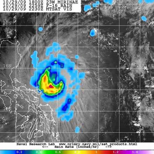
oaba09 wrote:Does anyone have an image showing the center of the typhoon? I can't seem to determine it based on the sat loops...thanks!
Dvorak image where you can see where the center is.Still above the 15N line.

0 likes
Visit the Caribbean-Central America Weather Thread where you can find at first post web cams,radars
and observations from Caribbean basin members Click Here
and observations from Caribbean basin members Click Here


-
beaufort12
- S2K Supporter
- Posts: 70
- Joined: Thu Sep 02, 2004 9:18 am
- Location: Lorton VA
Re: WPAC : TYPHOON MIRINAE (23W)=Metro Manila under Signal #2
Looks like this thing is quickly bearing down on Luzon. I wish the best for the S2k members and the other residents in and around the path of the storm. Prepare as best you can and be careful.
0 likes
-
oaba09
- S2K Supporter
- Posts: 1496
- Age: 39
- Joined: Thu Oct 01, 2009 10:02 am
- Location: Valenzuela, Philippines
- Contact:
Re: Re:
cycloneye wrote:oaba09 wrote:Does anyone have an image showing the center of the typhoon? I can't seem to determine it based on the sat loops...thanks!
Dvorak image where you can see where the center is.Still above the 15N line.
Thanks!
0 likes


-
ozonepete
- Professional-Met
- Posts: 4743
- Joined: Mon Sep 07, 2009 3:23 pm
- Location: From Ozone Park, NYC / Now in Brooklyn, NY
Re: WPAC : TYPHOON MIRINAE (23W)=Metro Manila under Signal #2
Moving very fast - 19KT. Center should be near or over Manila by 18Z on the 30th, around 1 AM Friday night/Saturday morning local time there.
0 likes
Who is online
Users browsing this forum: No registered users and 39 guests