WPAC : TROPICAL DEPRESSION MIRINAE (23W)
Moderator: S2k Moderators
-
ManilaTC

- WesternPacificWeather.com

- Posts: 593
- Age: 47
- Joined: Mon Oct 26, 2009 5:13 am
- Location: Mandaluyong City, Philippines
- Contact:
The Sierra Madre Mountain range is at its lowest at east of the Metro. Mountains there are so low that when you peek out a highrise office building here in Manila, it seems like just hillsides.
0 likes
The above post is NOT official and should not be used as such. It is my opinion and may or may not be backed by sound meteorological data. It is not endorsed by any professional institution or storm2k.org. Please refer to your official national weather agency.
WEB http://goo.gl/JDiKXB | FB https://goo.gl/N5sIle | @ManilaTC
WEB http://goo.gl/JDiKXB | FB https://goo.gl/N5sIle | @ManilaTC


Re: WPAC : TYPHOON MIRINAE (23W) PAGASA=TYPHOON SANTI
The posts in this forum are NOT official forecast and should not be used as such. They are just the opinion of the poster and may or may not be backed by sound meteorological data. They are NOT endorsed by any professional institution or storm2k.org. For official information, please refer to the NHC and NWS products.
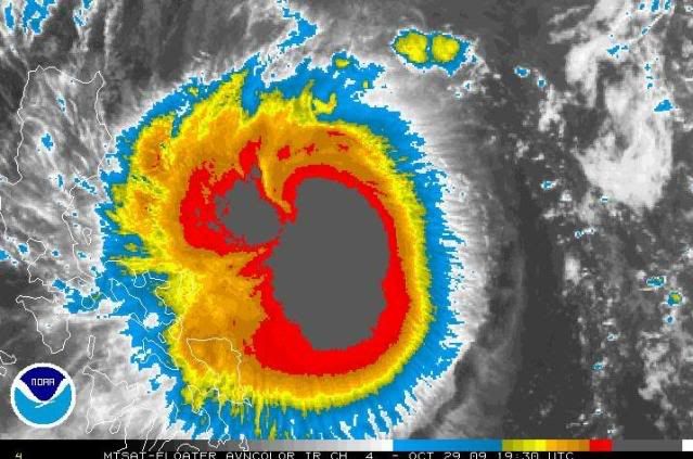
I don't think it is weakening, actually looks well organized and mey be intensifying a bit. The expansion of the size plus the strong convection is worrying. Good luck to all the folks on Philippines stay tuned and don't go outside.
I don't think it is weakening, actually looks well organized and mey be intensifying a bit. The expansion of the size plus the strong convection is worrying. Good luck to all the folks on Philippines stay tuned and don't go outside.
0 likes
-
Derek Ortt
-
ozonepete
- Professional-Met

- Posts: 4743
- Joined: Mon Sep 07, 2009 3:23 pm
- Location: From Ozone Park, NYC / Now in Brooklyn, NY
Re: WPAC : TYPHOON MIRINAE (23W) PAGASA=TYPHOON SANTI
Latest Dvorak ADT from CIMSS:
CI# /Pressure/ Vmax
3.9 / 980.2mb/ 63.0kt
Too low. I'd go 75-80 knots
CI# /Pressure/ Vmax
3.9 / 980.2mb/ 63.0kt
Too low. I'd go 75-80 knots
0 likes
-
ManilaTC
- WesternPacificWeather.com
- Posts: 593
- Age: 47
- Joined: Mon Oct 26, 2009 5:13 am
- Location: Mandaluyong City, Philippines
- Contact:
Re: WPAC : TYPHOON MIRINAE (23W) PAGASA=TYPHOON SANTI
Just got out for a peek... The stars are still out outside the house! But I see the cirrus... and the moon has a faint halo over it.
0 likes
The above post is NOT official and should not be used as such. It is my opinion and may or may not be backed by sound meteorological data. It is not endorsed by any professional institution or storm2k.org. Please refer to your official national weather agency.
WEB http://goo.gl/JDiKXB | FB https://goo.gl/N5sIle | @ManilaTC
WEB http://goo.gl/JDiKXB | FB https://goo.gl/N5sIle | @ManilaTC

Re: WPAC : TYPHOON MIRINAE (23W) PAGASA=TYPHOON SANTI
I am a total amature (new to this site). Okay so it looks like the eyewall is building...it is at Cat 2 (?) and possibly building, and headed directly for Manila. Fortunately moving pretty quick. My wife has family in Cavite, just south and along the edge of Manila Bay. How worried should she be about flash floods there?
0 likes
-
ozonepete
- Professional-Met
- Posts: 4743
- Joined: Mon Sep 07, 2009 3:23 pm
- Location: From Ozone Park, NYC / Now in Brooklyn, NY
Re: WPAC : TYPHOON MIRINAE (23W) PAGASA=TYPHOON SANTI
Looks like this will come in as strong, or almost as strong, as Xangsane from September of 2006. That one passed right over Manila with 90 mph and 4-6 inches of rain in the metro area. Get ready guys!
0 likes
-
ozonepete
- Professional-Met
- Posts: 4743
- Joined: Mon Sep 07, 2009 3:23 pm
- Location: From Ozone Park, NYC / Now in Brooklyn, NY
Re: WPAC : TYPHOON MIRINAE (23W) PAGASA=TYPHOON SANTI
Getting a little disorganized again on the northern semi-circle. Luckily this just can't seem to keep really good symmetry for very long. But boy are the rains gonna be bad.
0 likes
-
Derek Ortt
-
cycloneye

- Admin

- Posts: 149843
- Age: 69
- Joined: Thu Oct 10, 2002 10:54 am
- Location: San Juan, Puerto Rico
Re: WPAC : TYPHOON MIRINAE (23W) PAGASA=TYPHOON SANTI
dataclese wrote:I am a total amature (new to this site). Okay so it looks like the eyewall is building...it is at Cat 2 (?) and possibly building, and headed directly for Manila. Fortunately moving pretty quick. My wife has family in Cavite, just south and along the edge of Manila Bay. How worried should she be about flash floods there?
First,welcome to Storm2k.About Cavite,is better to be safe by evacuating the area than to be dealing with flooding in that area.As you said,its moving in a good clip and that could mitigate the rainfall amounts,but dont underestimate this as it will cause a good deal of damage in various ways.
0 likes
Visit the Caribbean-Central America Weather Thread where you can find at first post web cams,radars
and observations from Caribbean basin members Click Here
and observations from Caribbean basin members Click Here
-
ozonepete
- Professional-Met
- Posts: 4743
- Joined: Mon Sep 07, 2009 3:23 pm
- Location: From Ozone Park, NYC / Now in Brooklyn, NY
Re:
Derek Ortt wrote:if you match up the microwave eye with the IR, it is fairly well organized. The eye is where the curved bands come together
Oh, I totally agree with that. I was talking about the fact that the CDO is split into two main areas, a large one to the east and a smaller one to the northwest. That uneveness or lack of nice round symmetry of the tallest convection prevents the eye from spinning up all the way to the top and clearing out. Kind of like an ice-skater trying to do a spin with only one arm pulled in and the other sticking out.
0 likes
-
cycloneye
- Admin
- Posts: 149843
- Age: 69
- Joined: Thu Oct 10, 2002 10:54 am
- Location: San Juan, Puerto Rico
Re: WPAC : TYPHOON MIRINAE (23W) PAGASA=TYPHOON SANTI
18:00Z JTWC Warning=90kts
Track passes center just 30 miles north of Manila.

WTPN32 PGTW 292100
MSGID/GENADMIN/NAVMARFCSTCEN PEARL HARBOR HI/JTWC//
SUBJ/TROPICAL CYCLONE WARNING//
RMKS/
1. TYPHOON 23W (MIRINAE) WARNING NR 016
01 ACTIVE TROPICAL CYCLONE IN NORTHWESTPAC
MAX SUSTAINED WINDS BASED ON ONE-MINUTE AVERAGE
WIND RADII VALID OVER OPEN WATER ONLY
---
WARNING POSITION:
291800Z --- NEAR 15.2N 127.9E
MOVEMENT PAST SIX HOURS - 255 DEGREES AT 14 KTS
POSITION ACCURATE TO WITHIN 060 NM
POSITION BASED ON CENTER LOCATED BY SATELLITE
PRESENT WIND DISTRIBUTION:
MAX SUSTAINED WINDS - 090 KT, GUSTS 110 KT
WIND RADII VALID OVER OPEN WATER ONLY
RADIUS OF 064 KT WINDS - 040 NM NORTHEAST QUADRANT
030 NM SOUTHEAST QUADRANT
030 NM SOUTHWEST QUADRANT
040 NM NORTHWEST QUADRANT
RADIUS OF 050 KT WINDS - 060 NM NORTHEAST QUADRANT
050 NM SOUTHEAST QUADRANT
050 NM SOUTHWEST QUADRANT
055 NM NORTHWEST QUADRANT
RADIUS OF 034 KT WINDS - 140 NM NORTHEAST QUADRANT
100 NM SOUTHEAST QUADRANT
100 NM SOUTHWEST QUADRANT
140 NM NORTHWEST QUADRANT
REPEAT POSIT: 15.2N 127.9E
---
FORECASTS:
12 HRS, VALID AT:
300600Z --- 15.0N 125.0E
MAX SUSTAINED WINDS - 090 KT, GUSTS 110 KT
WIND RADII VALID OVER OPEN WATER ONLY
RADIUS OF 064 KT WINDS - 035 NM NORTHEAST QUADRANT
030 NM SOUTHEAST QUADRANT
030 NM SOUTHWEST QUADRANT
035 NM NORTHWEST QUADRANT
RADIUS OF 050 KT WINDS - 060 NM NORTHEAST QUADRANT
050 NM SOUTHEAST QUADRANT
055 NM SOUTHWEST QUADRANT
055 NM NORTHWEST QUADRANT
RADIUS OF 034 KT WINDS - 135 NM NORTHEAST QUADRANT
105 NM SOUTHEAST QUADRANT
105 NM SOUTHWEST QUADRANT
135 NM NORTHWEST QUADRANT
VECTOR TO 24 HR POSIT: 270 DEG/ 13 KTS
---
24 HRS, VALID AT:
301800Z --- 15.0N 122.3E
MAX SUSTAINED WINDS - 085 KT, GUSTS 105 KT
WIND RADII VALID OVER OPEN WATER ONLY
RADIUS OF 064 KT WINDS - 035 NM NORTHEAST QUADRANT
030 NM SOUTHEAST QUADRANT
030 NM SOUTHWEST QUADRANT
035 NM NORTHWEST QUADRANT
RADIUS OF 050 KT WINDS - 055 NM NORTHEAST QUADRANT
050 NM SOUTHEAST QUADRANT
050 NM SOUTHWEST QUADRANT
055 NM NORTHWEST QUADRANT
RADIUS OF 034 KT WINDS - 130 NM NORTHEAST QUADRANT
105 NM SOUTHEAST QUADRANT
105 NM SOUTHWEST QUADRANT
130 NM NORTHWEST QUADRANT
VECTOR TO 36 HR POSIT: 275 DEG/ 12 KTS
---
36 HRS, VALID AT:
310600Z --- 15.2N 119.9E
MAX SUSTAINED WINDS - 070 KT, GUSTS 085 KT
WIND RADII VALID OVER OPEN WATER ONLY
RADIUS OF 064 KT WINDS - 025 NM NORTHEAST QUADRANT
020 NM SOUTHEAST QUADRANT
020 NM SOUTHWEST QUADRANT
025 NM NORTHWEST QUADRANT
RADIUS OF 050 KT WINDS - 045 NM NORTHEAST QUADRANT
040 NM SOUTHEAST QUADRANT
040 NM SOUTHWEST QUADRANT
045 NM NORTHWEST QUADRANT
RADIUS OF 034 KT WINDS - 115 NM NORTHEAST QUADRANT
095 NM SOUTHEAST QUADRANT
100 NM SOUTHWEST QUADRANT
115 NM NORTHWEST QUADRANT
VECTOR TO 48 HR POSIT: 270 DEG/ 13 KTS
---
EXTENDED OUTLOOK:
48 HRS, VALID AT:
311800Z --- 15.1N 117.2E
MAX SUSTAINED WINDS - 065 KT, GUSTS 080 KT
WIND RADII VALID OVER OPEN WATER ONLY
RADIUS OF 050 KT WINDS - 040 NM NORTHEAST QUADRANT
035 NM SOUTHEAST QUADRANT
035 NM SOUTHWEST QUADRANT
040 NM NORTHWEST QUADRANT
RADIUS OF 034 KT WINDS - 105 NM NORTHEAST QUADRANT
090 NM SOUTHEAST QUADRANT
095 NM SOUTHWEST QUADRANT
110 NM NORTHWEST QUADRANT
VECTOR TO 72 HR POSIT: 265 DEG/ 13 KTS
---
72 HRS, VALID AT:
011800Z --- 14.7N 111.9E
MAX SUSTAINED WINDS - 060 KT, GUSTS 075 KT
WIND RADII VALID OVER OPEN WATER ONLY
RADIUS OF 050 KT WINDS - 030 NM NORTHEAST QUADRANT
030 NM SOUTHEAST QUADRANT
030 NM SOUTHWEST QUADRANT
035 NM NORTHWEST QUADRANT
RADIUS OF 034 KT WINDS - 090 NM NORTHEAST QUADRANT
080 NM SOUTHEAST QUADRANT
085 NM SOUTHWEST QUADRANT
095 NM NORTHWEST QUADRANT
VECTOR TO 96 HR POSIT: 265 DEG/ 14 KTS
---
LONG RANGE OUTLOOK:
NOTE...ERRORS FOR TRACK HAVE AVERAGED NEAR 250 NM
ON DAY 4 AND 350 NM ON DAY 5... AND FOR INTENSITY
NEAR 20 KT EACH DAY.
---
96 HRS, VALID AT:
021800Z --- 13.9N 106.1E
MAX SUSTAINED WINDS - 020 KT, GUSTS 030 KT
WIND RADII VALID OVER OPEN WATER ONLY
DISSIPATED AS A SIGNIFICANT TROPICAL CYCLONE OVER LAND
---
REMARKS:
292100Z POSITION NEAR 15.2N 127.2E.
TYPHOON (TY) 23W (MIRINAE), LOCATED APPROXIMATELY 400 NM EAST OF
MANILA, PHILIPPINES, HAS TRACKED WEST-SOUTHWESTWARD AT 14 KNOTS OVER
THE PAST SIX HOURS. ANIMATED INFRARED IMAGERY SHOWS THE SYSTEM HAS
MAINTAINED A CENTRAL DENSE OVERCAST PATTERN WHICH HAS MADE
POSITIONING USING INFRARED AND VISIBLE IMAGERY DIFFICULT. HOWEVER, A
291719Z AMSU IMAGE GIVES GOOD CONFIDENCE TO THE CURRENT POSITION.
THE CURRENT INTENSITY IS BASED ON DVORAK ESTIMATES OF 90 KNOTS FROM
PGTW AND RJTD. MIRINAE WILL CONTINUE TRACKING WESTWARD ALONG THE
SOUTHERN PERIPHERY OF THE SUBTROPICAL RIDGE AND IS EXPECTED TO
WEAKEN AS IT CROSSES LUZON, THOUGH IT WILL NOT SLOW SIGNIFICANTLY IN
FORWARD TRACK SPEED. ONCE IN THE SOUTH CHINA SEA, THE SYSTEM WILL
STEADILY WEAKEN AS IT ENCOUNTERS INCREASINGLY UNFAVORABLE VERTICAL
WIND SHEAR. BY TAU 72, MIRINAE WILL TURN MORE SOUTHWESTWARD AND
WEAKEN TO TROPICAL STORM STRENGTH AS AN EARLY-SEASON COLD SURGE
FURTHER INCREASES THE VERTICAL WIND SHEAR. THE MODEL GUIDANCE IS IN
VERY GOOD AGREEMENT WITH THIS FORECAST SCENARIO. MAXIMUM SIGNIFICANT
WAVE HEIGHT AT 291800Z IS 29 FEET. NEXT WARNINGS AT 300300Z,
300900Z, 301500Z AND 302100Z.//
Track passes center just 30 miles north of Manila.
WTPN32 PGTW 292100
MSGID/GENADMIN/NAVMARFCSTCEN PEARL HARBOR HI/JTWC//
SUBJ/TROPICAL CYCLONE WARNING//
RMKS/
1. TYPHOON 23W (MIRINAE) WARNING NR 016
01 ACTIVE TROPICAL CYCLONE IN NORTHWESTPAC
MAX SUSTAINED WINDS BASED ON ONE-MINUTE AVERAGE
WIND RADII VALID OVER OPEN WATER ONLY
---
WARNING POSITION:
291800Z --- NEAR 15.2N 127.9E
MOVEMENT PAST SIX HOURS - 255 DEGREES AT 14 KTS
POSITION ACCURATE TO WITHIN 060 NM
POSITION BASED ON CENTER LOCATED BY SATELLITE
PRESENT WIND DISTRIBUTION:
MAX SUSTAINED WINDS - 090 KT, GUSTS 110 KT
WIND RADII VALID OVER OPEN WATER ONLY
RADIUS OF 064 KT WINDS - 040 NM NORTHEAST QUADRANT
030 NM SOUTHEAST QUADRANT
030 NM SOUTHWEST QUADRANT
040 NM NORTHWEST QUADRANT
RADIUS OF 050 KT WINDS - 060 NM NORTHEAST QUADRANT
050 NM SOUTHEAST QUADRANT
050 NM SOUTHWEST QUADRANT
055 NM NORTHWEST QUADRANT
RADIUS OF 034 KT WINDS - 140 NM NORTHEAST QUADRANT
100 NM SOUTHEAST QUADRANT
100 NM SOUTHWEST QUADRANT
140 NM NORTHWEST QUADRANT
REPEAT POSIT: 15.2N 127.9E
---
FORECASTS:
12 HRS, VALID AT:
300600Z --- 15.0N 125.0E
MAX SUSTAINED WINDS - 090 KT, GUSTS 110 KT
WIND RADII VALID OVER OPEN WATER ONLY
RADIUS OF 064 KT WINDS - 035 NM NORTHEAST QUADRANT
030 NM SOUTHEAST QUADRANT
030 NM SOUTHWEST QUADRANT
035 NM NORTHWEST QUADRANT
RADIUS OF 050 KT WINDS - 060 NM NORTHEAST QUADRANT
050 NM SOUTHEAST QUADRANT
055 NM SOUTHWEST QUADRANT
055 NM NORTHWEST QUADRANT
RADIUS OF 034 KT WINDS - 135 NM NORTHEAST QUADRANT
105 NM SOUTHEAST QUADRANT
105 NM SOUTHWEST QUADRANT
135 NM NORTHWEST QUADRANT
VECTOR TO 24 HR POSIT: 270 DEG/ 13 KTS
---
24 HRS, VALID AT:
301800Z --- 15.0N 122.3E
MAX SUSTAINED WINDS - 085 KT, GUSTS 105 KT
WIND RADII VALID OVER OPEN WATER ONLY
RADIUS OF 064 KT WINDS - 035 NM NORTHEAST QUADRANT
030 NM SOUTHEAST QUADRANT
030 NM SOUTHWEST QUADRANT
035 NM NORTHWEST QUADRANT
RADIUS OF 050 KT WINDS - 055 NM NORTHEAST QUADRANT
050 NM SOUTHEAST QUADRANT
050 NM SOUTHWEST QUADRANT
055 NM NORTHWEST QUADRANT
RADIUS OF 034 KT WINDS - 130 NM NORTHEAST QUADRANT
105 NM SOUTHEAST QUADRANT
105 NM SOUTHWEST QUADRANT
130 NM NORTHWEST QUADRANT
VECTOR TO 36 HR POSIT: 275 DEG/ 12 KTS
---
36 HRS, VALID AT:
310600Z --- 15.2N 119.9E
MAX SUSTAINED WINDS - 070 KT, GUSTS 085 KT
WIND RADII VALID OVER OPEN WATER ONLY
RADIUS OF 064 KT WINDS - 025 NM NORTHEAST QUADRANT
020 NM SOUTHEAST QUADRANT
020 NM SOUTHWEST QUADRANT
025 NM NORTHWEST QUADRANT
RADIUS OF 050 KT WINDS - 045 NM NORTHEAST QUADRANT
040 NM SOUTHEAST QUADRANT
040 NM SOUTHWEST QUADRANT
045 NM NORTHWEST QUADRANT
RADIUS OF 034 KT WINDS - 115 NM NORTHEAST QUADRANT
095 NM SOUTHEAST QUADRANT
100 NM SOUTHWEST QUADRANT
115 NM NORTHWEST QUADRANT
VECTOR TO 48 HR POSIT: 270 DEG/ 13 KTS
---
EXTENDED OUTLOOK:
48 HRS, VALID AT:
311800Z --- 15.1N 117.2E
MAX SUSTAINED WINDS - 065 KT, GUSTS 080 KT
WIND RADII VALID OVER OPEN WATER ONLY
RADIUS OF 050 KT WINDS - 040 NM NORTHEAST QUADRANT
035 NM SOUTHEAST QUADRANT
035 NM SOUTHWEST QUADRANT
040 NM NORTHWEST QUADRANT
RADIUS OF 034 KT WINDS - 105 NM NORTHEAST QUADRANT
090 NM SOUTHEAST QUADRANT
095 NM SOUTHWEST QUADRANT
110 NM NORTHWEST QUADRANT
VECTOR TO 72 HR POSIT: 265 DEG/ 13 KTS
---
72 HRS, VALID AT:
011800Z --- 14.7N 111.9E
MAX SUSTAINED WINDS - 060 KT, GUSTS 075 KT
WIND RADII VALID OVER OPEN WATER ONLY
RADIUS OF 050 KT WINDS - 030 NM NORTHEAST QUADRANT
030 NM SOUTHEAST QUADRANT
030 NM SOUTHWEST QUADRANT
035 NM NORTHWEST QUADRANT
RADIUS OF 034 KT WINDS - 090 NM NORTHEAST QUADRANT
080 NM SOUTHEAST QUADRANT
085 NM SOUTHWEST QUADRANT
095 NM NORTHWEST QUADRANT
VECTOR TO 96 HR POSIT: 265 DEG/ 14 KTS
---
LONG RANGE OUTLOOK:
NOTE...ERRORS FOR TRACK HAVE AVERAGED NEAR 250 NM
ON DAY 4 AND 350 NM ON DAY 5... AND FOR INTENSITY
NEAR 20 KT EACH DAY.
---
96 HRS, VALID AT:
021800Z --- 13.9N 106.1E
MAX SUSTAINED WINDS - 020 KT, GUSTS 030 KT
WIND RADII VALID OVER OPEN WATER ONLY
DISSIPATED AS A SIGNIFICANT TROPICAL CYCLONE OVER LAND
---
REMARKS:
292100Z POSITION NEAR 15.2N 127.2E.
TYPHOON (TY) 23W (MIRINAE), LOCATED APPROXIMATELY 400 NM EAST OF
MANILA, PHILIPPINES, HAS TRACKED WEST-SOUTHWESTWARD AT 14 KNOTS OVER
THE PAST SIX HOURS. ANIMATED INFRARED IMAGERY SHOWS THE SYSTEM HAS
MAINTAINED A CENTRAL DENSE OVERCAST PATTERN WHICH HAS MADE
POSITIONING USING INFRARED AND VISIBLE IMAGERY DIFFICULT. HOWEVER, A
291719Z AMSU IMAGE GIVES GOOD CONFIDENCE TO THE CURRENT POSITION.
THE CURRENT INTENSITY IS BASED ON DVORAK ESTIMATES OF 90 KNOTS FROM
PGTW AND RJTD. MIRINAE WILL CONTINUE TRACKING WESTWARD ALONG THE
SOUTHERN PERIPHERY OF THE SUBTROPICAL RIDGE AND IS EXPECTED TO
WEAKEN AS IT CROSSES LUZON, THOUGH IT WILL NOT SLOW SIGNIFICANTLY IN
FORWARD TRACK SPEED. ONCE IN THE SOUTH CHINA SEA, THE SYSTEM WILL
STEADILY WEAKEN AS IT ENCOUNTERS INCREASINGLY UNFAVORABLE VERTICAL
WIND SHEAR. BY TAU 72, MIRINAE WILL TURN MORE SOUTHWESTWARD AND
WEAKEN TO TROPICAL STORM STRENGTH AS AN EARLY-SEASON COLD SURGE
FURTHER INCREASES THE VERTICAL WIND SHEAR. THE MODEL GUIDANCE IS IN
VERY GOOD AGREEMENT WITH THIS FORECAST SCENARIO. MAXIMUM SIGNIFICANT
WAVE HEIGHT AT 291800Z IS 29 FEET. NEXT WARNINGS AT 300300Z,
300900Z, 301500Z AND 302100Z.//
0 likes
Visit the Caribbean-Central America Weather Thread where you can find at first post web cams,radars
and observations from Caribbean basin members Click Here
and observations from Caribbean basin members Click Here

Re: WPAC : TYPHOON MIRINAE (23W) PAGASA=TYPHOON SANTI
Hi friends, I just wake up, I go out and look at the sky. The sunrise is beautiful here in Cebu philippines. I look to the east and the sky is red. Farther to the east, I see thick strands of cirrus clouds most likely belong to Mirinae. I just hope the Philippines will be ok and will not be battered so much by this typhoon.
0 likes
-
Derek Ortt
-
cycloneye
- Admin
- Posts: 149843
- Age: 69
- Joined: Thu Oct 10, 2002 10:54 am
- Location: San Juan, Puerto Rico
Re: WPAC : TYPHOON MIRINAE (23W) PAGASA=TYPHOON SANTI
5 AM Warning by Pagasa=Metro Manila under Signal 2
Track is over Metro Manila.

Track is over Metro Manila.
Typhoon "SANTI" continues to move closer to Aurora-Quezon area.
Location of Center:
(as of 4:00 a.m.) 580 km East Northeast of Infanta, Quezon
Coordinates: 15.6°N, 127.2°E
Strength: Maximum sustained winds of 150 kph near the center
and gustiness of up to 185 kph
Movement: West Southwest at 22 kph
Forecast Positions/Outlook: Saturday morning:
50 km East of Infanta, Quezon
Sunday morning:
370 km West of Manila
Monday morning:
840 km West of Manila
Code: Select all
Signal No.3

(100-185 kph winds)  Polillo Islands

Signal No. 2

(60-100 kph winds)  Aurora
Quirino
Nueva Ecija
Bulacan
Tarlac
Zambales
Pampanga
Bataan
Rizal
Cavite
Laguna
Batangas
Lubang Is.
Quezon
Camarines Norte
Camarines Sur
Catanduanes
Metro Manila

Signal No. 1
(30-60 kph winds)  Isabela
Ifugao
Nueva Vizcaya
Benguet
La Union
Pangasinan
Albay
Burias Is.
Sorsogon
Marinduque
Oriental Mindoro
Occidental Mindoro
Calamian Group
0 likes
Visit the Caribbean-Central America Weather Thread where you can find at first post web cams,radars
and observations from Caribbean basin members Click Here
and observations from Caribbean basin members Click Here
-
ozonepete
- Professional-Met
- Posts: 4743
- Joined: Mon Sep 07, 2009 3:23 pm
- Location: From Ozone Park, NYC / Now in Brooklyn, NY
Re:
Derek Ortt wrote:JTs track may be too far north at the longer time periods. This may strike Southern Vietnam and could move into the BOB is conditions are favorable
Yeah. If the ridge is strong to its north and west at that time it could slide southwestward under it. I could see that.
0 likes
-
ozonepete
- Professional-Met
- Posts: 4743
- Joined: Mon Sep 07, 2009 3:23 pm
- Location: From Ozone Park, NYC / Now in Brooklyn, NY
Re: WPAC : TYPHOON MIRINAE (23W) PAGASA=TYPHOON SANTI
cebuboy wrote:Hi friends, I just wake up, I go out and look at the sky. The sunrise is beautiful here in Cebu philippines. I look to the east and the sky is red. Farther to the east, I see thick strands of cirrus clouds most likely belong to Mirinae. I just hope the Philippines will be ok and will not be battered so much by this typhoon.
We have a saying here in the U.S.: "Red sky at night, sailor's delight. Red sky in the morning, sailor take warning."
0 likes
-
cycloneye
- Admin
- Posts: 149843
- Age: 69
- Joined: Thu Oct 10, 2002 10:54 am
- Location: San Juan, Puerto Rico
Re: WPAC : TYPHOON MIRINAE (23W) PAGASA=TYPHOON SANTI
For the friends that are waking up including stormchaser Jim,here are the three tracks of the 18:00Z warnings by JMA,JTWC and Pagasa.
JMA

JTWC
PAGASA
JMA
JTWC
PAGASA
0 likes
Visit the Caribbean-Central America Weather Thread where you can find at first post web cams,radars
and observations from Caribbean basin members Click Here
and observations from Caribbean basin members Click Here
-
ozonepete
- Professional-Met
- Posts: 4743
- Joined: Mon Sep 07, 2009 3:23 pm
- Location: From Ozone Park, NYC / Now in Brooklyn, NY
Re: WPAC : TYPHOON MIRINAE (23W) PAGASA=TYPHOON SANTI
Boy am I glad metenthusiast moved up his appointment. He's just going to make it before the really bad weather comes in, and he would never have been able to make a Saturday appointment. Whew!
0 likes
-
ozonepete
- Professional-Met
- Posts: 4743
- Joined: Mon Sep 07, 2009 3:23 pm
- Location: From Ozone Park, NYC / Now in Brooklyn, NY
Re: WPAC : TYPHOON MIRINAE (23W) PAGASA=TYPHOON SANTI
Thanks, cycloneye. Wow. They are all in remarkable agreement. This is a high confidence track forecast.
0 likes
Who is online
Users browsing this forum: No registered users and 40 guests